43:
29:
59:
66:
265:
589:
559:
440:. In the parish generally, the soils are shallow and well drained with limestone brash. There is some clay which is naturally rather poorly drained and occasionally waterlogged. It produces the wheat, barley, sugar beet and some potatoes usual in eastern England
597:
567:
474:. After closure various buildings were rented to a variety of small enterprises, and there are a large number of small businesses to be found to this day. Controversially two substantial fires occurred there in a short time.
305:
537:
282:
520:
set the land speed record for a steam locomotive, reaching 126 mph, unbeaten to this day. A commemorative sign was erected by the track near the milepost in 1998.
289:
313:
128:
251:
449:
33:
42:
349:
277:
833:
783:
797:
508:
331:
58:
294:
239:
205:
169:
121:
838:
497:
516:
459:
over its south door. It is built within the remains of the castle, which appears to have been a very early Norman
102:
28:
482:
341:
336:
803:
706:
414:
219:
489:. The railway line and station opened in 1852 and the station closed in 1966. The line is still very busy.
456:
493:
402:
270:
486:
406:
151:
453:
429:
187:
144:
111:
779:
667:
811:
636:
460:
244:
619:
467:
748:
734:
827:
720:
692:
652:
394:
195:
504:
410:
386:
471:
364:
351:
763:
British
Geological Survey, 1:50 000, Sheet 157, Solid and Drift edn. (1976).
229:
511:
466:
The village is dominated by a large industrial site, once the factory of
437:
675:
Transactions of the
Leicestershire Archaeological and Historical Society
433:
398:
390:
211:
177:
159:
79:
138:
641:. Victoria County History. Vol. 2. 1935. pp. XXVII–XLIV.
503:
On 3 July 1938, north of
Essendine and just over the border in
496:
to
Essendine line (via Belmesthorpe) which opened in 1856. The
492:
The station also became the main line terminus of the short
816:. Victoria County History. Vol. 2. pp. 250–254.
735:"National Monument record:Stamford and Essendine railway"
749:"National Monument Record:Bourne and Essendine railway"
668:"Early Castles in the Medieval Landscape of Rutland"
304:
288:
276:
264:
250:
238:
228:
218:
204:
186:
168:
150:
136:
120:
109:
97:
89:
21:
810:Page, William, ed. (1935). "Parishes: Essendine".
463:later developing into a strongly fortified manor.
769:Soils England and Wales Scale 1:250 000. Sheet 4.
596:. Office for National Statistics. Archived from
566:. Office for National Statistics. Archived from
417:, close by the earthworks of a small castle.
8:
800:. The castle earthworks are among the trees.
436:, though the church and castle are on river
413:at the 2011 census was 448. It lies on the
721:"National Monument Record:Railway station"
420:The village's name means 'valley of Esa'.
18:
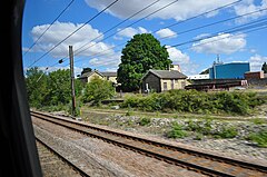
47:Former goods yard from a northbound train
806:Open directory listing for this village.
707:"Newspaper account of reaction to fires"
93:2.31 sq mi (6.0 km)
818:Extensive early history of the village.
529:
303:
259:
227:
203:
135:
119:
88:
39:
25:
500:(old spelling) opened on 16 May 1860.
34:Church of St Mary Magdalene, Essendine
631:
629:
287:
275:
263:
249:
237:
217:
185:
167:
149:
108:
7:
389:at the eastern end of the county of
813:A History of the County of Rutland
638:A History of the County of Rutland
538:"A vision of Britain through time"
401:, located 5 miles (7 km) north of
14:
693:"National Monument record:castle"
653:"National Monument record:Church"
65:
64:
57:
41:
27:
590:"Civil Parish population 2011"
560:"Civil Parish population 2011"
1:
405:and 6 miles (10 km) south of
620:"Key to English Place-names"
498:Bourn and Essendine Railway
450:Church of St Mary Magdalene
122:OS grid reference
16:Human settlement in England
855:
798:A photograph of the church
666:Creighton, Oliver (1999).
540:. University of Portsmouth
432:or Upper Estuarine Series
428:Most of the village is on
834:Civil parishes in Rutland
483:Essendine railway station
322:
300:
260:
52:
40:
26:
594:Neighbourhood Statistics
564:Neighbourhood Statistics
409:. The population of the
514:locomotive number 4468
143:84 miles (135 km)
365:52.700120°N 0.457225°W
240:Postcode district
170:Ceremonial county
152:Unitary authority
116:159/sq mi (61/km)
487:East Coast Main Line
370:52.700120; -0.457225
220:Sovereign state
839:Villages in Rutland
776:Bourne to Essendine
430:Blisworth Limestone
361: /
600:on 11 October 2016
570:on 11 October 2016
314:Rutland and Melton
306:UK Parliament
252:Dialling code
507:at Milepost 90¼,
385:is a village and
380:
379:
846:
817:
753:
752:
745:
739:
738:
731:
725:
724:
717:
711:
710:
703:
697:
696:
689:
683:
682:
672:
663:
657:
656:
649:
643:
642:
633:
624:
623:
616:
610:
609:
607:
605:
586:
580:
579:
577:
575:
556:
550:
549:
547:
545:
534:
376:
375:
373:
372:
371:
366:
362:
359:
358:
357:
354:
328:
214:
132:
131:
78:Location within
68:
67:
61:
45:
31:
19:
854:
853:
849:
848:
847:
845:
844:
843:
824:
823:
809:
794:
789:
757:
756:
747:
746:
742:
733:
732:
728:
719:
718:
714:
705:
704:
700:
691:
690:
686:
670:
665:
664:
660:
651:
650:
646:
635:
634:
627:
618:
617:
613:
603:
601:
588:
587:
583:
573:
571:
558:
557:
553:
543:
541:
536:
535:
531:
526:
480:
446:
426:
369:
367:
363:
360:
355:
352:
350:
348:
347:
346:
326:
318:
210:
200:
182:
164:
127:
126:
85:
84:
83:
82:
76:
75:
74:
73:
69:
48:
36:
17:
12:
11:
5:
852:
850:
842:
841:
836:
826:
825:
820:
819:
807:
801:
793:
792:External links
790:
788:
787:
772:
765:
758:
755:
754:
740:
726:
712:
698:
684:
658:
644:
625:
611:
581:
551:
528:
527:
525:
522:
479:
476:
468:Allis Chalmers
452:has a notable
445:
442:
425:
422:
378:
377:
345:
344:
339:
334:
329:
327:List of places
323:
320:
319:
317:
316:
310:
308:
302:
301:
298:
297:
292:
286:
285:
283:Leicestershire
280:
274:
273:
271:Leicestershire
268:
262:
261:
258:
257:
254:
248:
247:
242:
236:
235:
232:
226:
225:
224:United Kingdom
222:
216:
215:
208:
202:
201:
199:
198:
192:
190:
184:
183:
181:
180:
174:
172:
166:
165:
163:
162:
156:
154:
148:
147:
141:
134:
133:
124:
118:
117:
114:
107:
106:
99:
95:
94:
91:
87:
86:
77:
71:
70:
63:
62:
56:
55:
54:
53:
50:
49:
46:
38:
37:
32:
24:
23:
15:
13:
10:
9:
6:
4:
3:
2:
851:
840:
837:
835:
832:
831:
829:
822:
815:
814:
808:
805:
802:
799:
796:
795:
791:
785:
784:0-948017-03-1
781:
777:
773:
770:
766:
764:
760:
759:
750:
744:
741:
736:
730:
727:
722:
716:
713:
708:
702:
699:
694:
688:
685:
680:
676:
669:
662:
659:
654:
648:
645:
640:
639:
632:
630:
626:
621:
615:
612:
599:
595:
591:
585:
582:
569:
565:
561:
555:
552:
539:
533:
530:
523:
521:
519:
518:
513:
510:
506:
501:
499:
495:
490:
488:
484:
477:
475:
473:
469:
464:
462:
458:
455:
451:
443:
441:
439:
435:
431:
423:
421:
418:
416:
412:
408:
404:
400:
396:
395:East Midlands
392:
388:
384:
374:
343:
340:
338:
335:
333:
330:
325:
324:
321:
315:
312:
311:
309:
307:
299:
296:
295:East Midlands
293:
291:
284:
281:
279:
272:
269:
267:
255:
253:
246:
243:
241:
233:
231:
223:
221:
213:
209:
207:
197:
196:East Midlands
194:
193:
191:
189:
179:
176:
175:
173:
171:
161:
158:
157:
155:
153:
146:
142:
140:
130:
125:
123:
115:
113:
104:
100:
96:
92:
81:
60:
51:
44:
35:
30:
20:
821:
812:
775:
768:
762:
743:
729:
715:
701:
687:
678:
674:
661:
647:
637:
614:
602:. Retrieved
598:the original
593:
584:
572:. Retrieved
568:the original
563:
554:
542:. Retrieved
532:
515:
505:Lincolnshire
502:
491:
481:
465:
447:
427:
419:
411:civil parish
387:civil parish
382:
381:
774:Rhodes, J.
544:11 February
485:was on the
478:The railway
368: /
103:2011 Census
828:Categories
524:References
472:Fiat-Allis
448:The small
353:52°42′00″N
101:448 (
98:Population
804:Essendine
444:Buildings
415:West Glen
383:Essendine
356:0°27′26″W
290:Ambulance
230:Post town
72:Essendine
22:Essendine
512:Class A4
494:Stamford
470:, later
457:tympanum
438:alluvium
403:Stamford
234:STAMFORD
129:TF043124
778:(1986)
771:(1983).
604:24 June
574:24 June
517:Mallard
434:geology
424:Geology
399:England
393:in the
391:Rutland
342:Rutland
337:England
212:England
206:Country
178:Rutland
160:Rutland
137:•
112:Density
110:•
80:Rutland
782:
767:Anon.
761:Anon.
461:bailey
454:Norman
407:Bourne
266:Police
188:Region
139:London
671:(PDF)
256:01780
780:ISBN
606:2016
576:2016
546:2009
509:LNER
278:Fire
90:Area
397:of
245:PE9
145:SSE
830::
679:73
677:.
673:.
628:^
592:.
562:.
332:UK
786:.
751:.
737:.
723:.
709:.
695:.
681:.
655:.
622:.
608:.
578:.
548:.
105:)
Text is available under the Creative Commons Attribution-ShareAlike License. Additional terms may apply.