231:
261:, England. It developed from a farmstead during the twentieth century, the name may be based on the old Roman name Colonia Glevensis, or the name could be based on an original field name "Long Elevens". This could have related to a long field about eleven acres therefore this could have been adopted as a name for the hamlet, first recorded in 1750, as part of the estate of Gloucester Cathedral. One of the oldest roads is 'The Avenue', which is shown on old maps as a number of farm cottages built in the 1850s. The population of Longlevens was 9,532 at the time of the
54:
38:
239:
223:
317:
Cheltenham Road between
Elmbridge Road and Oxstalls Lane. All the streets were officially named in January 1935 according to the Gloucester Journal 1st January 1935. The estate was completed by 1938. In 1948 a new section of the estate was added with the building of local authority housing called The Triangle. The contract was awarded to Ashmores (Builders) of Gloucester. The houses were completed around 1951.
61:
313:
simply country lanes before they became the busy throughways we know today. Gloucestershire
Archives have retained many of the original plans for housing within the suburb. The earliest building control files date from 1909 when the area was under the control of the Gloucester Rural District Council.
316:
The
Wellsprings estate began its life in 1933 when a Swindon-based builder A.J. Colborne put an application in to build 28 houses on the site. All streets within the estate are named after locations in the Lake District, apart from Wellsprings Road. Which is named after a property that used to sit on
312:
Longlevens developed its housing from the 1880s onwards with the fields along the main routes through the original village. Plots were created in
Cheltenham and Church Roads, at the Longlevens crossroads housing began to develop from the Edwardian period onward. Longford & Innsworth Lanes were
357:
Of clubs playing association football the most important was
Gloucester City Association Football Club, originating in 1889 and re-formed in 1925. From 1935 it had its ground at Longlevens and in 1964 it moved to a new stadium in Horton Road, which was later also used for greyhound racing. A more
296:, and Wotton St. Mary (Without). The demands of Gloucester's growing population in the 19th century increased market gardening in the hamlets and by 1843 J. C. Wheeler's nurseries included a large area between Kingsholm and Wotton. In 1851 market gardeners were fairly numerous in
362:
which opened in 1933 and closed in 1983. Longlevens is home to a semi-professional team in
Longlevens AFC who have a range of adult, women's, youth and junior teams playing at several locations in the area (Longford Lane, Innsworth Lane and Longlevens Infant School).
380:
285:
in the new civil parish of
Longlevens, north-east of Gloucester. Parts of Longlevens were added to Gloucester in 1951 and in 1967 when the remainder was re-formed as Innsworth civil parish.
103:
288:
Orcharding, which was increased at
Innsworth in the mid 19th century, remained an important feature and in 1896 covered at least 172 a. in the parishes of Gloucester,
234:
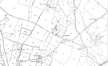
The hamlet of
Longleavens on a c.1880 Ordnance Survey map. Innsworth Cottage and Norman's Place to the north, Elmbridge to the east, Oxstalls to the south.
189:
53:
359:
181:
171:
330:
139:
499:
230:
349:, which skirts its Eastern edge to flood several homes and roads, particularly Greyhound Gardens and Cypress Gardens.
402:
326:
342:
262:
297:
289:
176:
153:
304:, and later there were several market gardens and nurseries at Longlevens (called Springfield) and Innsworth.
37:
333:, Kendal Road Baptist Church, Longlevens Junior School, Longlevens Infants School and various shops.
85:
346:
238:
129:
121:
93:
222:
430:, A History of the County of Gloucester: Volume 4: The City of Gloucester (1988), pp. 311-317.
427:
258:
111:
74:
18:
This article is about the suburb. For the civil parish formerly called
Longlevens, see
493:
462:
282:
278:
254:
204:
191:
301:
293:
19:
406:
274:
145:
237:
229:
221:
484:
479:
440:
273:
Wotton St. Mary (Without), save for a few acres given to
242:
The centre of Longlevens on a 1950s Ordnance Survey map.
281:, was included with parts of Barnwood, Churchdown, and
325:
Longlevens is primarily residential, and is home to
152:
138:
120:
102:
84:
30:
341:A small part of Longlevens was affected by the
358:important centre for greyhound racing was the
8:
405:. Holy Trinity, Longlevens. Archived from
27:
372:
137:
34:
151:
119:
101:
83:
7:
428:"Gloucester: Modern parish churches"
360:Gloucester & Cheltenham Stadium
60:
14:
381:"Gloucester Ward population 2011"
59:
52:
36:
485:http://www.mylonglevens.co.uk/
443:. Krbc.org.uk. 31 January 2010
1:
353:Football and greyhound racing
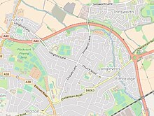
226:Longlevens within Gloucester.
25:Human settlement in England
516:
480:http://www.longlevens.org/
403:"Holy Trinity, Longlevens"
401:Holy Trinity, Longlevens.
17:
162:
47:
35:
327:Sir Thomas Rich's School
321:Character and facilities
441:"Kendal Road Home Page"
243:
235:
227:
241:
233:
225:
205:51.87787°N 2.21701°W
154:Sovereign state
500:Areas of Gloucester
331:Holy Trinity Church
201: /
42:Holy Trinity Church
409:on 11 January 2014
244:
236:
228:
210:51.87787; -2.21701
253:, is a suburb of
220:
219:
104:Shire county
507:
467:
466:
459:
453:
452:
450:
448:
437:
431:
425:
419:
418:
416:
414:
398:
392:
391:
389:
387:
377:
343:July 2007 floods
216:
215:
213:
212:
211:
206:
202:
199:
198:
197:
194:
168:
148:
73:Location within
63:
62:
56:
40:
28:
515:
514:
510:
509:
508:
506:
505:
504:
490:
489:
476:
471:
470:
461:
460:
456:
446:
444:
439:
438:
434:
426:
422:
412:
410:
400:
399:
395:
385:
383:
379:
378:
374:
369:
355:
339:
323:
310:
271:
259:Gloucestershire
209:
207:
203:
200:
195:
192:
190:
188:
187:
186:
182:Gloucestershire
166:
144:
134:
116:
112:Gloucestershire
98:
80:
79:
78:
77:
75:Gloucestershire
71:
70:
69:
68:
64:
43:
26:
23:
12:
11:
5:
513:
511:
503:
502:
492:
491:
488:
487:
482:
475:
474:External links
472:
469:
468:
454:
432:
420:
393:
371:
370:
368:
365:
354:
351:
347:Horsbere Brook
345:; this caused
338:
335:
322:
319:
309:
306:
270:
267:
218:
217:
185:
184:
179:
174:
169:
167:List of places
163:
160:
159:
158:United Kingdom
156:
150:
149:
142:
136:
135:
133:
132:
126:
124:
118:
117:
115:
114:
108:
106:
100:
99:
97:
96:
90:
88:
82:
81:
72:
66:
65:
58:
57:
51:
50:
49:
48:
45:
44:
41:
33:
32:
24:
13:
10:
9:
6:
4:
3:
2:
512:
501:
498:
497:
495:
486:
483:
481:
478:
477:
473:
464:
463:"School News"
458:
455:
442:
436:
433:
429:
424:
421:
408:
404:
397:
394:
382:
376:
373:
366:
364:
361:
352:
350:
348:
344:
336:
334:
332:
328:
320:
318:
314:
307:
305:
303:
299:
295:
291:
286:
284:
280:
276:
268:
266:
264:
260:
256:
252:
249:, originally
248:
240:
232:
224:
214:
183:
180:
178:
175:
173:
170:
165:
164:
161:
157:
155:
147:
143:
141:
131:
128:
127:
125:
123:
113:
110:
109:
107:
105:
95:
92:
91:
89:
87:
76:
55:
46:
39:
29:
21:
16:
457:
445:. Retrieved
435:
423:
411:. Retrieved
407:the original
396:
384:. Retrieved
375:
356:
340:
324:
315:
311:
287:
272:
250:
246:
245:
15:
447:13 February
413:13 February
292:, Tuffley,
263:2011 Census
251:Longleavens
208: /
386:27 October
367:References
283:Hucclecote
279:Churchdown
255:Gloucester
247:Longlevens
193:51°52′40″N
130:South West
94:Gloucester
67:Longlevens
31:Longlevens
302:Twigworth
294:Twigworth
196:2°13′01″W
20:Innsworth
494:Category
337:Flooding
298:Longford
290:Longford
275:Barnwood
86:District
308:Housing
269:History
177:England
146:England
140:Country
122:Region
257:, in
449:2014
415:2014
388:2015
300:and
277:and
496::
329:,
265:.
172:UK
465:.
451:.
417:.
390:.
22:.
Text is available under the Creative Commons Attribution-ShareAlike License. Additional terms may apply.