219:
1115:
1135:
535:
232:
655:
995:
1015:
955:
1055:
495:
1197:
1075:
875:
1155:
855:
795:
715:
515:
1237:
1095:
975:
895:
815:
595:
935:
835:
775:
415:
1175:
252:
1035:
915:
675:
575:
455:
635:
695:
615:
475:
1217:
395:
735:
555:
435:
1565:
755:
139:
and has therefore become a major thoroughfare for traffic running both east and west and north and south. The Aar River traverses it from west to east, and the primary motorway of
Switzerland (the A1) and the main Bern-Zürich railway run through it, making it a central transport region.
359:
was created on 1 January 2010. It is part of the
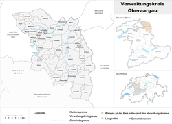
Emmental-Oberaargau administrative region and includes 45 municipalities over an area of (based on the 2004/09/16 survey) of 331.04 km (127.82 sq mi), and as of 31 December 2020, 82,472 residents.
1323:
As the political influence of the city of Bern increased in the late Middle Ages, the
Oberaargau came more and more into its sphere of influence. In the 15th century, Bern conquered both the Oberaargau and the
1554:
1393:
1394:
Amtliches
Gemeindeverzeichnis der Schweiz, Mutationsmeldungen 2009 / Répertoire officiel des communes de Suisse, Mutations 2009 / Elenco ufficiale dei Comuni della Svizzera, Mutazione 2009
1638:
1331:
When Bern lost its old power in 1798, the
Unteraargau became the modern canton of Aargau. The boundary between the Oberaargau and Unteraargau was fixed in 1798 along the
1547:
1427:
1653:
1643:
159:
are important transportation centers. Since the building of the motorway, the primary economic development has taken place in the north, at the foot of the
1540:
1618:
218:
1400:
1628:
1114:
1681:
1648:
1525:
1633:
1568:
1707:
1658:
1134:
534:
18:
1702:
1663:
338:
654:
1014:
954:
1443:"Ständige und nichtständige Wohnbevölkerung nach institutionellen Gliederungen, Geburtsort und Staatsangehörigkeit"
1532:
994:
494:
1676:
1120:
81:
1196:
1174:
1074:
874:
1054:
144:
109:
1154:
854:
794:
714:
514:
244:
124:. It is connected to the rest of the canton of Bern only in the south, where it borders on the Emmenthal.
1236:
1094:
974:
894:
814:
594:
634:
317:
1497:
1316:, the area was divided among the counts of Froburg, Aarwangen (later Grünenberg), Zähringen (later the
934:
834:
774:
414:
1140:
540:
327:
101:
89:
1034:
914:
674:
574:
454:
1592:
152:
73:
694:
614:
474:
394:
1582:
1348:
1181:
267:
175:
113:
1216:
1442:
1020:
960:
734:
554:
105:
85:
1587:
1340:
1313:
1303:
121:
434:
660:
500:
148:
1602:
1080:
356:
257:
160:
77:
59:
1696:
1279:
1160:
1000:
754:
128:
55:
100:
It lies in the extreme northeast corner of the canton and includes the districts of
1623:
1597:
1332:
1100:
640:
820:
1518:
1512:
1506:
1336:
1325:
1299:
1202:
1060:
940:
880:
237:
164:
1564:
1286:
1040:
920:
860:
800:
720:
520:
168:
80:. Historically (until 2009), the Oberaargau comprised the two administrative
33:
20:
1468:
1242:
980:
900:
620:
600:
400:
308:
179:
156:
51:
136:
1449:(in German). Swiss Federal Statistical Office - STAT-TAB. 31 December 2020
1344:
1317:
840:
780:
760:
420:
63:
740:
680:
580:
560:
460:
385:
376:
700:
480:
440:
334:
313:
117:
371:
1222:
183:
1399:(Report). Federal Statistical Office. 2009. 2776. Archived from
132:
1536:
69:
Administratively, the
Oberaargau forms a district within the
1428:
Arealstatistik
Standard - Gemeindedaten nach 4 Hauptbereichen
1298:
The region was already known as the
Oberaargau in the early
363:
366:
50:
is the region that encompasses the upper watershed of the
182:, at 1231 meters, and the lowest point is on the Aare at
1309:). However, this concept also included the Emmenthal.
1611:
1575:
345:
324:
307:
299:
291:
286:
278:
273:
263:
243:
225:
199:
1423:
1421:
1548:
1519:
1437:
1435:
1285:On 1 January 2024 the former municipality of
1278:On 1 January 2021 the former municipality of
8:
1513:
1507:
174:The highest point in the Oberaargaus is the
62:, and on the south the hills leading to the
1335:. In 1802, however, it was shifted west to
1555:
1541:
1533:
196:
1475:. Swiss Federal Statistical Office. 2021
1339:river. This action was confirmed by the
131:between the large population centers of
1385:
1365:
344:
306:
285:
282:331.04 km (127.82 sq mi)
272:
224:
215:
58:in Switzerland. On the north, lie the
1469:"Applikation der Schweizer Gemeinden"
323:
298:
290:
277:
262:
242:
112:. It is surrounded by the cantons of
7:
1682:Municipalities of the canton of Bern
1526:Historical Dictionary of Switzerland
1569:Subdivisions of the canton of Bern
14:
1563:
1235:
1215:
1195:
1173:
1153:
1133:
1113:
1093:
1073:
1053:
1033:
1013:
993:
973:
953:
933:
913:
893:
873:
853:
833:
813:
793:
773:
753:
733:
713:
693:
673:
653:
633:
613:
593:
573:
553:
533:
513:
493:
473:
453:
433:
413:
393:
250:
230:
217:
1289:merged into Wangen an der Aare.
355:The Oberaargau District in the
163:, particularly in the towns of
1372:Based on the 2004/09/16 survey
108:, and part of the district of
1:
1498:Regional Web site (in German)
1264:
1261:
1249:
1246:
1234:
1229:
1226:
1214:
1209:
1206:
1194:
1189:
1186:
1172:
1167:
1164:
1152:
1147:
1144:
1132:
1127:
1124:
1112:
1107:
1104:
1092:
1087:
1084:
1072:
1067:
1064:
1052:
1047:
1044:
1032:
1027:
1024:
1012:
1007:
1004:
992:
987:
984:
972:
967:
964:
952:
947:
944:
932:
927:
924:
912:
907:
904:
892:
887:
884:
872:
867:
864:
852:
847:
844:
832:
827:
824:
812:
807:
804:
792:
787:
784:
772:
767:
764:
752:
747:
744:
732:
727:
724:
712:
707:
704:
692:
687:
684:
672:
667:
664:
652:
647:
644:
632:
627:
624:
612:
607:
604:
592:
587:
584:
572:
567:
564:
552:
547:
544:
532:
527:
524:
512:
507:
504:
492:
487:
484:
472:
467:
464:
452:
447:
444:
432:
427:
424:
412:
407:
404:
392:
1307:superior pagus Aragauginsis
204:Verwaltungskreis Oberaargau
127:The Oberaargau lies on the
1724:
1593:Emmental-Oberaargau Region
1672:
216:
209:
1708:Geography of Switzerland
1677:Districts of Switzerland
1639:Frutigen-Niedersimmental
1121:Walliswil bei Niederbipp
1328:and ruled them as one.
1282:merged into Langenthal.
303:250/km (650/sq mi)
194:District in Switzerland
190:Administrative district
178:in the municipality of
1703:Regions of Switzerland
326: • Summer (
1654:Obersimmental-Saanen
1644:Interlaken-Oberhasli
1141:Walliswil bei Wangen
541:Busswil bei Melchnau
300: • Density
143:The primary city is
1598:Jura Bernois Region
1406:on 18 November 2010
201:Oberaargau District
147:, and the towns of
74:Emmental-Oberaargau
30: /
1583:Bernese Mittelland
1349:Congress of Vienna
1182:Wangen an der Aare
382:(31 December 2020)
292: • Total
279: • Total
268:Wangen an der Aare
1690:
1689:
1269:
1268:
383:
353:
352:
186:, at 405 meters.
54:in the canton of
1715:
1588:Bernese Oberland
1567:
1557:
1550:
1543:
1534:
1521:
1515:
1509:
1485:
1484:
1482:
1480:
1465:
1459:
1458:
1456:
1454:
1439:
1430:
1425:
1416:
1415:
1413:
1411:
1405:
1398:
1390:
1373:
1370:
1347:in 1803 and the
1341:Act of Mediation
1314:High Middle Ages
1239:
1219:
1199:
1177:
1157:
1137:
1117:
1097:
1077:
1057:
1037:
1017:
997:
977:
957:
937:
917:
897:
877:
857:
837:
817:
797:
777:
757:
737:
717:
697:
677:
657:
637:
617:
597:
577:
557:
537:
517:
497:
477:
457:
437:
417:
397:
381:
364:
331:
256:
254:
253:
236:
234:
233:
221:
197:
45:
44:
42:
41:
40:
35:
34:47.183°N 7.750°E
31:
28:
27:
26:
23:
1723:
1722:
1718:
1717:
1716:
1714:
1713:
1712:
1693:
1692:
1691:
1686:
1668:
1619:Bern-Mittelland
1607:
1571:
1561:
1494:
1489:
1488:
1478:
1476:
1467:
1466:
1462:
1452:
1450:
1441:
1440:
1433:
1426:
1419:
1409:
1407:
1403:
1396:
1392:
1391:
1387:
1377:
1376:
1371:
1367:
1357:
1296:
1275:
1270:
661:Herzogenbuchsee
380:
325:
251:
249:
231:
229:
212:
205:
202:
195:
192:
149:Herzogenbuchsee
98:
38:
36:
32:
29:
24:
21:
19:
17:
16:
12:
11:
5:
1721:
1719:
1711:
1710:
1705:
1695:
1694:
1688:
1687:
1685:
1684:
1679:
1673:
1670:
1669:
1667:
1666:
1661:
1656:
1651:
1646:
1641:
1636:
1631:
1626:
1621:
1615:
1613:
1609:
1608:
1606:
1605:
1600:
1595:
1590:
1585:
1579:
1577:
1573:
1572:
1562:
1560:
1559:
1552:
1545:
1537:
1531:
1530:
1523:in the online
1500:
1493:
1492:External links
1490:
1487:
1486:
1460:
1431:
1417:
1384:
1383:
1382:
1381:
1375:
1374:
1364:
1363:
1362:
1361:
1356:
1353:
1295:
1292:
1291:
1290:
1283:
1274:
1271:
1267:
1266:
1263:
1260:
1255:
1252:
1251:
1248:
1245:
1240:
1232:
1231:
1228:
1225:
1220:
1212:
1211:
1208:
1205:
1200:
1192:
1191:
1188:
1185:
1178:
1170:
1169:
1166:
1163:
1158:
1150:
1149:
1146:
1143:
1138:
1130:
1129:
1126:
1123:
1118:
1110:
1109:
1106:
1103:
1098:
1090:
1089:
1086:
1083:
1078:
1070:
1069:
1066:
1063:
1058:
1050:
1049:
1046:
1043:
1038:
1030:
1029:
1026:
1023:
1021:Schwarzhäusern
1018:
1010:
1009:
1006:
1003:
998:
990:
989:
986:
983:
978:
970:
969:
966:
963:
961:Rohrbachgraben
958:
950:
949:
946:
943:
938:
930:
929:
926:
923:
918:
910:
909:
906:
903:
898:
890:
889:
886:
883:
878:
870:
869:
866:
863:
858:
850:
849:
846:
843:
838:
830:
829:
826:
823:
818:
810:
809:
806:
803:
798:
790:
789:
786:
783:
778:
770:
769:
766:
763:
758:
750:
749:
746:
743:
738:
730:
729:
726:
723:
718:
710:
709:
706:
703:
698:
690:
689:
686:
683:
678:
670:
669:
666:
663:
658:
650:
649:
646:
643:
638:
630:
629:
626:
623:
618:
610:
609:
606:
603:
598:
590:
589:
586:
583:
578:
570:
569:
566:
563:
558:
550:
549:
546:
543:
538:
530:
529:
526:
523:
518:
510:
509:
506:
503:
498:
490:
489:
486:
483:
478:
470:
469:
466:
463:
458:
450:
449:
446:
443:
438:
430:
429:
426:
423:
418:
410:
409:
406:
403:
398:
390:
389:
384:
375:
370:
362:
357:Canton of Bern
351:
350:
347:
346:Municipalities
343:
342:
332:
322:
321:
311:
305:
304:
301:
297:
296:
293:
289:
288:
284:
283:
280:
276:
275:
271:
270:
265:
261:
260:
247:
241:
240:
227:
223:
222:
214:
213:
210:
207:
206:
203:
200:
193:
191:
188:
161:Jura Mountains
97:
94:
78:canton of Bern
60:Jura Mountains
13:
10:
9:
6:
4:
3:
2:
1720:
1709:
1706:
1704:
1701:
1700:
1698:
1683:
1680:
1678:
1675:
1674:
1671:
1665:
1662:
1660:
1657:
1655:
1652:
1650:
1647:
1645:
1642:
1640:
1637:
1635:
1632:
1630:
1627:
1625:
1622:
1620:
1617:
1616:
1614:
1610:
1604:
1601:
1599:
1596:
1594:
1591:
1589:
1586:
1584:
1581:
1580:
1578:
1574:
1570:
1566:
1558:
1553:
1551:
1546:
1544:
1539:
1538:
1535:
1528:
1527:
1522:
1516:
1510:
1504:
1501:
1499:
1496:
1495:
1491:
1474:
1470:
1464:
1461:
1448:
1444:
1438:
1436:
1432:
1429:
1424:
1422:
1418:
1402:
1395:
1389:
1386:
1379:
1378:
1369:
1366:
1359:
1358:
1354:
1352:
1350:
1346:
1342:
1338:
1334:
1329:
1327:
1321:
1319:
1315:
1310:
1308:
1305:
1301:
1293:
1288:
1284:
1281:
1280:Obersteckholz
1277:
1276:
1272:
1259:
1256:
1254:
1253:
1244:
1241:
1238:
1233:
1224:
1221:
1218:
1213:
1204:
1201:
1198:
1193:
1184:
1183:
1179:
1176:
1171:
1162:
1159:
1156:
1151:
1142:
1139:
1136:
1131:
1122:
1119:
1116:
1111:
1102:
1099:
1096:
1091:
1082:
1079:
1076:
1071:
1062:
1059:
1056:
1051:
1042:
1039:
1036:
1031:
1022:
1019:
1016:
1011:
1002:
999:
996:
991:
982:
979:
976:
971:
962:
959:
956:
951:
942:
939:
936:
931:
922:
919:
916:
911:
902:
899:
896:
891:
882:
879:
876:
871:
862:
859:
856:
851:
842:
839:
836:
831:
822:
819:
816:
811:
802:
799:
796:
791:
782:
779:
776:
771:
762:
759:
756:
751:
742:
739:
736:
731:
722:
719:
716:
711:
702:
699:
696:
691:
682:
679:
676:
671:
662:
659:
656:
651:
642:
639:
636:
631:
622:
619:
616:
611:
602:
599:
596:
591:
582:
579:
576:
571:
562:
559:
556:
551:
542:
539:
536:
531:
522:
519:
516:
511:
502:
499:
496:
491:
482:
479:
476:
471:
462:
459:
456:
451:
442:
439:
436:
431:
422:
419:
416:
411:
402:
399:
396:
391:
388:
379:
374:
369:
365:
361:
358:
348:
340:
336:
333:
329:
319:
315:
312:
310:
302:
294:
281:
269:
266:
259:
248:
246:
239:
228:
220:
208:
198:
189:
187:
185:
181:
177:
172:
170:
166:
162:
158:
154:
150:
146:
141:
138:
134:
130:
129:Swiss Plateau
125:
123:
119:
115:
111:
107:
103:
95:
93:
91:
87:
83:
79:
75:
72:
67:
65:
61:
57:
53:
49:
43:
39:47.183; 7.750
1624:Bernese Jura
1524:
1502:
1477:. Retrieved
1473:bfs.admin.ch
1472:
1463:
1453:21 September
1451:. Retrieved
1447:bfs.admin.ch
1446:
1408:. Retrieved
1401:the original
1388:
1368:
1333:Wigger River
1330:
1322:
1311:
1306:
1297:
1257:
1180:
641:Heimenhausen
501:Bettenhausen
386:
377:
372:
367:
354:
173:
142:
126:
110:Trachselwald
99:
70:
68:
47:
15:
1629:Biel/Bienne
1326:Unteraargau
1300:Middle Ages
1203:Wiedlisbach
1081:Thunstetten
881:Oeschenbach
238:Switzerland
176:Höllchöpfli
165:Wiedlisbach
37: /
1697:Categories
1649:Oberaargau
1503:Oberaargau
1479:26 January
1355:References
1287:Wangenried
1161:Walterswil
1001:Rütschelen
861:Ochlenberg
801:Niederbipp
721:Langenthal
521:Bleienbach
387:Area in km
378:Population
287:Population
169:Niederbipp
145:Langenthal
48:Oberaargau
1612:Districts
1380:Citations
1351:in 1815.
1318:Habsburgs
1243:Wyssachen
1101:Ursenbach
981:Rumisberg
901:Reisiswil
821:Niederönz
601:Gondiswil
401:Aarwangen
309:Time zone
180:Rumisberg
157:Aarwangen
114:Solothurn
102:Aarwangen
96:Geography
90:Aarwangen
82:districts
52:Aar River
1634:Emmental
1345:Napoleon
1061:Thörigen
941:Rohrbach
841:Oberbipp
781:Melchnau
761:Madiswil
421:Attiswil
211:District
64:Emmental
1659:Seeland
1603:Seeland
1576:Regions
1520:Italian
1410:6 March
1312:In the
1294:History
1273:Mergers
1265:331.04
1262:82,472
1041:Seeberg
921:Roggwil
741:Lotzwil
725:15,544
681:Huttwil
581:Farnern
561:Eriswil
461:Bannwil
264:Capital
226:Country
122:Lucerne
76:of the
22:47°11′N
1514:French
1508:German
1250:11.69
1247:1,103
1227:1,624
1207:2,382
1187:2,377
1085:3,458
1065:1,156
1045:1,559
945:1,520
925:4,176
845:1,753
825:1,691
808:19.77
805:5,097
788:10.27
785:1,488
768:23.17
765:3,284
745:2,663
728:21.13
701:Inkwil
688:17.24
685:5,009
665:7,293
645:1,136
621:Graben
568:11.34
565:1,358
481:Berken
441:Auswil
425:1,532
405:4,638
368:Border
295:82,472
255:
245:Canton
235:
155:, and
153:Wangen
137:Zürich
120:, and
118:Aargau
106:Wangen
86:Wangen
71:region
25:7°45′E
1404:(PDF)
1397:(PDF)
1360:Notes
1304:Latin
1258:Total
1230:5.07
1223:Wynau
1190:5.22
1168:7.87
1088:9.66
1068:4.55
1048:16.8
1028:3.79
1008:3.98
988:5.14
968:6.46
948:4.08
928:7.84
908:2.01
888:3.92
848:8.45
828:2.79
748:6.22
708:3.38
668:9.82
648:5.84
628:3.16
588:3.68
548:2.86
528:5.69
508:3.94
488:1.39
468:4.78
448:4.62
428:7.65
335:UTC+2
314:UTC+1
184:Wynau
1664:Thun
1517:and
1505:in
1481:2021
1455:2021
1412:2010
1337:Murg
1302:(in
1210:7.5
1165:540
1148:9.9
1145:604
1128:9.9
1125:227
1108:9.9
1105:881
1025:533
1005:564
985:491
965:390
905:173
885:220
868:9.9
865:563
705:628
625:336
608:9.4
605:711
585:227
545:177
525:734
505:642
465:676
445:448
408:9.9
373:Name
339:CEST
274:Area
258:Bern
167:and
135:and
133:Bern
104:and
88:and
56:Bern
46:The
1343:of
1320:).
485:44
328:DST
318:CET
84:of
1699::
1511:,
1471:.
1445:.
1434:^
1420:^
349:43
171:.
151:,
116:,
92:.
66:.
1556:e
1549:t
1542:v
1529:.
1483:.
1457:.
1414:.
341:)
337:(
330:)
320:)
316:(
Text is available under the Creative Commons Attribution-ShareAlike License. Additional terms may apply.