50:
112:
140:
38:
410:
402:. In 1817, Polsbroek was divided into 7 separate municipalities again. Until 1857, Polsbroek was divided along the Benschopse Wetering into two parts: Noord-Polsbroek and Zuid-Polsbroek. On September 8, 1857 Noord-Polsbroek and Zuid-Polsbroek again merged to a single municipality. In 1989 the municipality Polsbroek became a part of
59:
188:
The village of
Polsbroek consists of a ribbon of farms on both sides of the Benschopse Wetering, with a small centre on the west side of the village. In 2001, the village centre of Polsbroek had 421 inhabitants. The built-up area of the town was 0.06 km (0.023 sq mi), and contained 143
459:
522:
C. Pijnacker
Hordijk, Opgaven omtrent inkomsten, goederen, hoorigen, dienstmannen en rechten der abdij Egmond (1130-1161), in: Bijdragen en Mededeelingen van het Historisch Genootschap 21 (1900), p. 161-185; here at p.
58:
456:
759:
629:
477:
754:
735:
598:
582:
622:
536:, band II, part 1, Medioburgi: apud Petrum Gillissen et fil. et Isaac de Winter, 1780, p. 166-169 (Codex Diplomaticus, Nr. XXVIII), p. 168 ..
374:
In 1812, a single municipality "Polsbroek" was created, covering both Noord-Polsbroek and Zuid-Polsbroek, and several surrounding villages (
423:
336:
478:
http://www.cbs.nl/nl-NL/menu/themas/nederland-regionaal/nederland-regionaal/publicaties/gemeente-op-maat/2004/alfabet/l/2004-lopik.htm
639:
615:
72:
189:
residences. The wider statistical area of
Polsbroek, which covers the complete former municipality, including the
37:
63:
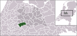
The town centre (darkgreen) and the statistical district (lightgreen) of
Polsbroek in the municipality of Lopik.
104:
549:
497:("History of the municipal boundaries in the province Utrecht from 1795 to 1940"), Provinciale Almanak, 1962
364:
575:
560:
177:
399:
360:
169:
127:
607:
673:
541:
719:
534:
Historia critica comitatus
Hollandiae et Zeelandiae ab antiquissimis inde deducta temporibus
340:
49:
586:
463:
433:
313:
246:
764:
709:
379:
328:
261:
194:
748:
368:
688:
319:
302:
197:, has a population of 1190, and an area of about 11 km (4.2 sq mi).
190:
165:
117:
495:
Geschiedenis van de gemeentegrenzen in de provincie
Utrecht van 1795 tot 1940
87:
74:
683:
348:
344:
724:
391:
387:
506:
409:
395:
394:). Between 1814 and 1817, half of the municipality lay in the province
356:
714:
678:
375:
657:
643:
403:
383:
301:. Since 1155 the (local) lords of Polsbroek are able to speak the
173:
145:
297:(from 1228 to 1229), Polsbroic, about 1296 and 1317, and than to
611:
351:. As a free a high fief, Zuid-Polsbroek was an independent (
285:
In the early 12th century
Polsbroek itself was called first
277:(*): includes Cabauw, Vliet, Vlist, Zevender, Hoenkoop.
367:
to the east. Noord-Polsbroek was itself a part of that
327:, the lowest category of local jurisdictions, while
702:
666:
650:
151:
133:
123:
103:
21:
548:, band 1, Osthoek, Utrecht 1920, p. 371 (Nr. 410)
457:Statistics are for the continuous built-up area.
309:) middle and low justice over their territory.
736:List of cities, towns and villages in Utrecht
623:
546:Oorkondenboek van het sticht Utrecht tot 1301
8:
760:Former municipalities of Utrecht (province)
630:
616:
608:
544:. New Publishing by Samuel Muller et al.,
18:
176:, and lies about 10 km southeast of
408:
199:
445:
428:List of Lords of the Free and high fief
150:
102:
67:
46:
34:
755:Populated places in Utrecht (province)
489:
487:
485:
473:
471:
172:. It is a part of the municipality of
599:Repertorium van Nederlandse gemeenten
132:
122:
55:
7:
424:Free and high fief of Zuid-Polsbroek
337:Free and high fief of Zuid-Polsbroek
597:Ad van der Meer and Onno Boonstra,
312:Until the end of the 18th century,
454:Bevolkingskernen in Nederland 2001
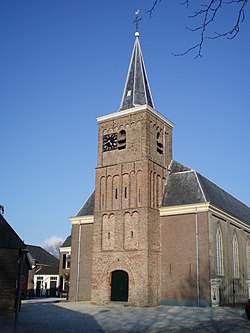
42:Dutch Reformed Church of Polsbroek
14:
138:
110:
57:
48:
36:
16:Village in Utrecht, Netherlands
452:Statistics Netherlands (CBS),
398:, while the other half was in
1:
509:Gemeente Atlas van Nederland
781:
333:vrije en hoge heerlijkheid
733:
68:
56:
47:
35:
28:
638:Populated places in the
511:, 1865-1870, "Polsbroek"
414:
201:Number of inhabitants
412:
365:Barony of IJsselstein
164:is a village in the
88:51.97806°N 4.85194°E
561:Noord-Polsbroek at
355:) of the provinces
202:
84: /
585:2007-02-12 at the
576:Zuid-Polsbroek at
462:2007-01-24 at the
415:
363:, like the larger
353:semisouverain fief
200:
193:and the hamlet of
742:
741:
578:Heren van Holland
563:Heren van Holland
538:cum omni iusticia
275:
274:
159:
158:
93:51.97806; 4.85194
772:
720:Willige Langerak
632:
625:
618:
609:
602:
595:
589:
573:
567:
558:
552:
530:
524:
520:
514:
504:
498:
491:
480:
475:
466:
450:
289:, changing into
203:
144:
142:
141:
116:
114:
113:
99:
98:
96:
95:
94:
89:
85:
82:
81:
80:
77:
61:
52:
40:
19:
780:
779:
775:
774:
773:
771:
770:
769:
745:
744:
743:
738:
729:
698:
662:
646:
636:
606:
605:
596:
592:
587:Wayback Machine
574:
570:
559:
555:
532:Adriaan Kluit,
531:
527:
521:
517:
505:
501:
492:
483:
476:
469:
464:Wayback Machine
451:
447:
442:
434:Noord-Polsbroek
420:
314:Noord-Polsbroek
283:
247:Noord-Polsbroek
191:ribbon of farms
186:
139:
137:
111:
109:
92:
90:
86:
83:
78:
75:
73:
71:
70:
64:
43:
31:
24:
17:
12:
11:
5:
778:
776:
768:
767:
762:
757:
747:
746:
740:
739:
734:
731:
730:
728:
727:
722:
717:
712:
710:Polsbroekerdam
706:
704:
700:
699:
697:
696:
691:
686:
681:
676:
670:
668:
664:
663:
661:
660:
654:
652:
648:
647:
637:
635:
634:
627:
620:
612:
604:
603:
601:, KNAW, 2011.
590:
568:
553:
525:
515:
499:
493:W.A.G. Perks,
481:
467:
444:
443:
441:
438:
437:
436:
431:
419:
416:
339:), during the
329:Zuid-Polsbroek
282:
279:
273:
272:
269:
266:
264:
262:Zuid-Polsbroek
258:
257:
254:
251:
249:
243:
242:
239:
236:
233:
230:
227:
223:
222:
219:
216:
213:
210:
207:
195:Polsbroekerdam
185:
182:
157:
156:
153:
149:
148:
135:
131:
130:
125:
121:
120:
107:
101:
100:
66:
65:
62:
54:
53:
45:
44:
41:
33:
32:
29:
26:
25:
22:
15:
13:
10:
9:
6:
4:
3:
2:
777:
766:
763:
761:
758:
756:
753:
752:
750:
737:
732:
726:
723:
721:
718:
716:
713:
711:
708:
707:
705:
701:
695:
692:
690:
687:
685:
682:
680:
677:
675:
672:
671:
669:
665:
659:
656:
655:
653:
649:
645:
641:
633:
628:
626:
621:
619:
614:
613:
610:
600:
594:
591:
588:
584:
581:
579:
572:
569:
566:
564:
557:
554:
551:
547:
543:
539:
535:
529:
526:
519:
516:
512:
510:
503:
500:
496:
490:
488:
486:
482:
479:
474:
472:
468:
465:
461:
458:
455:
449:
446:
439:
435:
432:
429:
425:
422:
421:
417:
411:
407:
405:
401:
397:
393:
389:
385:
381:
377:
372:
370:
366:
362:
358:
354:
350:
346:
343:owned by the
342:
338:
334:
330:
326:
322:
321:
315:
310:
308:
304:
300:
296:
292:
288:
280:
278:
270:
267:
265:
263:
260:
259:
255:
252:
250:
248:
245:
244:
240:
237:
234:
231:
228:
225:
224:
220:
217:
214:
211:
208:
205:
204:
198:
196:
192:
183:
181:
179:
175:
171:
167:
163:
154:
147:
136:
129:
126:
119:
108:
106:
97:
69:Coordinates:
60:
51:
39:
27:
20:
693:
689:Lopikerkapel
640:municipality
593:
577:
571:
562:
556:
550:Google books
545:
542:Google books
537:
533:
528:
518:
508:
502:
494:
453:
448:
427:
373:
352:
347:family from
332:
324:
320:heerlijkheid
317:
311:
306:
298:
294:
293:in 1155, to
290:
286:
284:
276:
187:
168:province of
161:
160:
134:Municipality
507:J. Kuyper,
307:blood court
118:Netherlands
91: /
749:Categories
440:References
341:Golden Age
325:schoutambt
291:Pulsebroch
287:Pulzabruch
152:Population
76:51°58′41″N
694:Polsbroek
684:Jaarsveld
349:Amsterdam
345:De Graeff
299:Polsbroek
226:Polsbroek
162:Polsbroek
23:Polsbroek
725:Zevender
674:Benschop
667:Villages
583:Archived
460:Archived
418:See also
392:Hoenkoop
388:Zevender
295:Pusbruch
184:Overview
124:Province
79:4°51′7″E
703:Hamlets
400:Utrecht
396:Holland
361:Utrecht
357:Holland
281:History
229:1295(*)
170:Utrecht
128:Utrecht
105:Country
30:Village
715:Uitweg
679:Cabauw
390:, and
376:Cabauw
369:Barony
331:was a
316:was a
221:2004
218:1868
215:1849
212:1829
209:1812
143:
115:
765:Lopik
658:Lopik
651:Towns
644:Lopik
404:Lopik
384:Vlist
380:Vliet
318:lage
241:1190
206:Year
178:Gouda
174:Lopik
166:Dutch
155:1,250
146:Lopik
580:(nl)
565:(nl)
303:high
271:273
256:407
642:of
540:...
523:170
359:or
323:or
268:229
253:393
238:700
235:680
232:622
751::
484:^
470:^
406:.
386:,
382:,
378:,
371:.
180:.
631:e
624:t
617:v
513:.
430:)
426:(
413:.
335:(
305:(
Text is available under the Creative Commons Attribution-ShareAlike License. Additional terms may apply.