337:
271:
287:
255:
303:
320:
54:
144:
235:. The rock itself, however, was probably not used as a place to shout from, as it was surrounded by water (during average sea level conditions) according to old maps from the end of the 17th century, in particular a map from 1696. When there was an extreme low sea level it was probably possible to reach the rock by foot, as indicated on the painting by
336:
242:
The entire area, named
Ropsten, dramatically changed appearance in just a few years when the first bridge between Ropsten and Lidingö and the main port for Stockholm was built in this area from around 1884. Today nothing remains of the old Ropsten as it appears on the painting from 1795.
218:
The name "Ropsten" stems from the fact that in old times, going back to the 13th or 14th century, people used to shout out loud from this area to Lidingö, a distance of about 750 meters, to call for a boat transport over to
210:
Ropsten has been the communication center for the traffic between
Stockholm and Lidingö since the 13th or 14th century, when the first inhabitants settled on Lidingö and began farming, 200–300 years after the end of the
382:. When there is high atmospheric pressure in the Baltic area compared to the atmospheric pressure in the North Sea for a longer period, the water is pressed out into the Atlantic Ocean and the water level will sink.
351:
in a rowboat ferry after a visit to the island in
September 1789. The boat is the kind of broad boat normally used for transport of bulky goods, horses and cattle etc. with two rowers.
223:, before the first regular rowboat ferry line was introduced and before the first bridge was built. In the old times, the part of the Ropsten area close to the waterfront was named
270:
286:
254:
374:
normally fluctuates between -0.5 meter to +0.5 meter, in extreme case up to one meter, depending on atmospheric tide differences between the Baltic Sea and the
159:(to the left). The large rock in the middle of the painting has named the place. A ferry is on its way from Ropsten to Lidingö with a horse and cart on board.
64:
302:
398:
319:
79:
18:
122:
94:
101:
108:
236:
148:
344:
90:
326:
195:
309:
199:
379:
191:
179:
392:
115:
151:
from 1795 showing the area around
Ropsten before the first bridge was built between
231:
in the water close to this cape gave the place its name, "the rock at cape shout",
171:
53:
371:
348:
220:
212:
187:
183:
156:
33:
20:
375:
167:
152:
143:
202:, the railway for public transportation, covering the area of Lidingö.
175:
228:
47:
194:. Ropsten is the terminal station for the eastern part of
71:
75:
227:(corresponding to "cape shout"). The large rock or
293:Map from 1874, covering the area around Ropsten.
277:Map from 1784, covering the area around Ropsten.
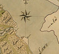
261:Map from 1696, covering the area around Ropsten.
8:
198:system and is also the terminal station for
80:introducing citations to additional sources
182:extend from Ropsten over to the island of
170:mainland at the inner part of Stockholm
142:
70:Relevant discussion may be found on the
363:
250:
247:Image gallery, Ropsten year 1696-2008
7:
186:. Ropsten area is located between
14:
295:Map orientation; north facing up.
279:Map orientation; north facing up.
263:Map orientation; north facing up.
190:and the Stockholm city main port
166:is a cape at the eastern part of
335:
318:
301:
285:
269:
253:
63:relies largely or entirely on a
52:
1:
329:platform at Ropsten station.
312:at Ropsten railway station.
415:
399:Geography of Stockholm
160:
370:The sea level in the
146:
34:59.35778°N 18.10389°E
345:Carl Michael Bellman
178:. Two bridges named
76:improve this article
343:A painting showing
155:(to the right) and
30: /
237:Piere Joseph Trere
161:
149:Piere Joseph Trere
39:59.35778; 18.10389
352:
330:
313:
296:
280:
264:
141:
140:
126:
406:
383:
368:
342:
339:
325:
322:
308:
305:
292:
289:
276:
273:
260:
257:
136:
133:
127:
125:
84:
56:
48:
45:
44:
42:
41:
40:
35:
31:
28:
27:
26:
23:
414:
413:
409:
408:
407:
405:
404:
403:
389:
388:
387:
386:
369:
365:
360:
353:
340:
331:
323:
314:
306:
297:
294:
290:
281:
278:
274:
265:
262:
258:
249:
208:
196:Stockholm Metro
137:
131:
128:
85:
83:
69:
57:
38:
36:
32:
29:
24:
21:
19:
17:
16:
12:
11:
5:
412:
410:
402:
401:
391:
390:
385:
384:
380:Atlantic Ocean
362:
361:
359:
356:
355:
354:
341:
334:
332:
324:
317:
315:
307:
300:
298:
291:
284:
282:
275:
268:
266:
259:
252:
248:
245:
207:
204:
139:
138:
74:. Please help
60:
58:
51:
13:
10:
9:
6:
4:
3:
2:
411:
400:
397:
396:
394:
381:
377:
373:
367:
364:
357:
350:
346:
338:
333:
328:
321:
316:
311:
304:
299:
288:
283:
272:
267:
256:
251:
246:
244:
240:
238:
234:
230:
226:
222:
216:
214:
205:
203:
201:
197:
193:
189:
185:
181:
177:
173:
169:
165:
158:
154:
150:
145:
135:
124:
121:
117:
114:
110:
107:
103:
100:
96:
93: –
92:
88:
87:Find sources:
81:
77:
73:
67:
66:
65:single source
61:This article
59:
55:
50:
49:
46:
43:
366:
310:Lidingöbanan
241:
232:
224:
217:
209:
200:Lidingöbanan
163:
162:
147:Painting by
129:
119:
112:
105:
98:
86:
62:
15:
239:from 1795.
192:Värtahamnen
180:Lidingöbron
172:archipelago
37: /
372:Baltic Sea
213:Viking Age
188:Hjorthagen
132:March 2015
102:newspapers
25:18°06′14″E
22:59°21′28″N
376:North Sea
358:Footnotes
168:Stockholm
153:Stockholm
91:"Ropsten"
72:talk page
393:Category
347:leaving
225:Ropudden
378:in the
349:Lidingö
233:Ropsten
221:Lidingö
206:History
184:Lidingö
164:Ropsten
157:Lidingö
116:scholar
176:Sweden
118:
111:
104:
97:
89:
327:Metro
229:islet
123:JSTOR
109:books
95:news
174:in
78:by
395::
215:.
134:)
130:(
120:·
113:·
106:·
99:·
82:.
68:.
Text is available under the Creative Commons Attribution-ShareAlike License. Additional terms may apply.