31:
471:
47:
54:
232:
429:
Throughout history the population has changed; from the start of the census in 1801 the population steadily increased and reached a peak of 507 in 1831, after which it decreased slightly to 495 before increasing again (with the exception of 1921 where it was 530) in 1881 from 500. There was a slight
446:
Rushbury had the most arable land compared to the surrounding manors. In 1086 it had: "two ploughteams in demesne worked by 4 servi, while 1 villanus, 2 bordars, and 3 radmen worked five more". Rushbury also had enough woodland in the Middle Ages to fatten 40 swine and about 1250, one pig in ten
407:
The name
Rushbury is thought to derive from Rush Manor, but other evidence suggests that it could originate from the Old English 'risc', literally meaning 'a place where rushes grow', and the Old English word 'burh', meaning a 'fortified place'; putting the two together gives 'Rush Fortification'.
420:
it was 5,620 acres, before decreasing to 4,132 acres by the 1851 census and then increasing to 6,304 by 1891, where it has remained ever since. Rushbury CP now includes the settlements of East Wall, Longville in the Dale, Lushcott, Stanway, Stone Acton and Wall under
Haywood.
659:
There are many established paths and public rights of way, the nearest main public bridle path being Coats Wood which connects to other bridle ways, some of which run almost the entire length of
Wenlock Edge. There are also established cycle networks nearby.
880:
689:
493:
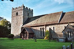
The founding date of the church is unknown, but was most likely built around Saxon times and the name St Peter was known by around 1740. Between 1548 and 1792 the church belonged to the lord of
Rushbury manor. A rectory was built around 1260.
466:
In 2001 the vast majority of people worked in agriculture (51 people) or in retail trade (39) or education (30). Most people worked away from home travelling by car or van (163) but a high proportion also worked from home (90).
1239:
1165:
650:
There is a bus that passes close to
Rushbury. The 540 Shrewsbury - Cardington service operates Monday-Friday (excludes bank holidays) during school term time. The bus stop is located by the Village Hall.
1191:
621:
Rushbury Road runs through
Rushbury Village itself and connects to the B4371, which in turn connects to the nearest major road A49 that runs through Church Stretton and goes to Shrewsbury in the north.
497:
It is known that in 1716 there were two Sunday services, one with a sermon and communion six times a year. In the mid 18th century, sacrament offerings (charity money) were given to the poor.
451:
and been made warren land. In 1086 one water mill was recorded at
Rushbury and a tanner was supposed to have lived here in 1602. A link showing a pie chart of occupational categories in 1831
1656:
460:
456:
272:
792:
601:
Three rivers flow past or near
Rushbury: Lakehouse Brook flows right next to the village, while Heath Brook and Coley Brook run near the village and within Rushbury CP itself.
855:
431:
1077:
256:
93:
1651:
1671:
526:, replacing an older clock of 1789. Inside the church is a wall tablet listing these men, and another to the apparent only local man to die in the
218:
1666:
463:. The yellow areas represent common land, brown arable land, dark green mixed forest and purple houses with gardens, allotments and orchards.
30:
1717:
1661:
1017:
1472:
1305:
1635:
280:
244:
580:
531:
249:
46:
933:
316:
298:
1088:
1712:
1691:
631:
261:
206:
172:
1315:
136:
1676:
1646:
1641:
840:
86:
1686:
1626:
669:
542:
417:
308:
470:
1681:
353:
303:
1055:
522:
The church clock, on the west side of the tower, was placed in 1921 in memory of parish men who died serving in
1298:
959:
186:
818:
1534:
987:
A History of the County of
Shropshire: Volume 10: Munslow Hundred (part), The Liberty and Borough of Wenlock
912:
A History of the County of
Shropshire: Volume 10: Munslow Hundred (part), The Liberty and Borough of Wenlock
770:
A History of the County of Shropshire: Volume 10: Munslow Hundred (part), The Liberty and Borough of Wenlock
716:
A History of the County of Shropshire: Volume 10: Munslow Hundred (part), The Liberty and Borough of Wenlock
566:
1595:
1494:
1464:
1453:
372:
162:
416:
hill fort. The area of Rushbury Civil Parish (CP) has changed throughout history. According to the 1831
1631:
1616:
1554:
1519:
1394:
1336:
569:
376:
1217:
1032:
118:
1443:
1414:
1291:
501:
598:
rock a type of limestone much like Wenlock Edge itself. Rushbury lies about 200m above sea level.
1611:
1341:
384:
237:
154:
126:
1359:
1113:
982:
907:
500:
In the 1800s, the rector of Rushbury received £40 a year in half of grain and corn tithes from
452:
1621:
1379:
1013:
834:
535:
391:
608:
at 5 km (5 miles) and is about 26 km (16 miles) from the county town of Shrewsbury
1590:
1585:
1580:
765:
711:
576:
546:
527:
516:
478:
211:
1139:
1374:
605:
553:
361:
455:. Over three-quarters of the male population aged over 20 were involved in agriculture
1504:
1404:
482:
1706:
1529:
1043:
448:
443:
1559:
1539:
1489:
1409:
584:
365:
102:
1283:
1564:
1514:
1499:
1389:
523:
1549:
1544:
1509:
1448:
1429:
1364:
1321:
380:
357:
144:
67:
331:
318:
1524:
588:
508:
409:
196:
519:
begin in 1538, but there are several gaps in the 16th and 17th centuries.
447:
was given to the lord of Lutwyche. However, by 1301 most of Rushbury had
1419:
1369:
639:
595:
512:
413:
821:. Rushbury Parish Council. Archived from the original on 27 October 2011
1434:
1424:
504:, Gilberries, Wall under Haywood and other parts of Rushbury township.
178:
1265:
738:
1438:
1399:
635:
481:, a 16th-century country house restored in 1936 and now owned by the
469:
459:. A map showing land utilisation of Rushbury in 1942 can be seen
1384:
1287:
587:
to the southeast. About 7 km (4 miles) to the west is the
1459:
511:
with the costs being met by subscriptions and grants from the
485:, is used as a Youth Hostel. It is a grade I listed building.
507:
The church was restored in 1855-1856 by William Hill of
434:. According to the 2001 census the population was 603.
583:(ANOB) and sits in a valley, known as Ape Dale, with
1604:
1573:
1482:
1350:
1329:
530:, Stanley Thomas Hughes. The churchyard contains a
271:
255:
243:
231:
217:
205:
195:
185:
171:
153:
135:
117:
101:
85:
77:
23:
387:. Longville and Wall lie within Rushbury parish.
1010:Shropshire War Memorials, Sites of Remembrance
1299:
8:
390:Rushbury is a quiet rural community, with a
1306:
1292:
1284:
20:
1078:"Detailed map of Shropshire Hills AONB"
1045:Photo of Robert Hart's grave on Flickr.
1012:. YouCaxton Publications. p. 124.
681:
515:Diocesan Church Building Society. The
270:
226:
194:
170:
84:
27:
832:
408:Human activity has been present since
254:
242:
230:
216:
204:
184:
152:
134:
116:
7:
1473:List of civil parishes in Shropshire
1114:"South geological map of Shropshire"
432:see chart on population of Rushbury
581:Area of Outstanding Natural Beauty
35:St Peter's parish church, Rushbury
14:
1087:. Ordnance Survey. Archived from
541:Also buried in the churchyard is
887:. Office for National Statistics
797:A Vision of Britain Through Time
634:and has services to Shrewsbury,
604:The nearest major settlement is
53:
52:
45:
29:
632:Church Stretton railway station
552:The church was made a grade II
1056:"Church of St Peter, Rushbury"
799:. 1831 Census of Great Britain
690:"Civil Parish population 2011"
1:
1218:"540 Shrewsbury - Cardington"
743:Survey of English Place-Names
630:The nearest train station is
1718:Civil parishes in Shropshire
1652:Parliamentary constituencies
960:"Wilderhope Manor, Rushbury"
881:"Rushbury parish headcounts"
670:Listed buildings in Rushbury
543:Robert Hart (horticulturist)
412:times and there was once an
1220:. Shropshire County Council
575:Rushbury is located in the
394:church and primary school.
87:OS grid reference
18:Human settlement in England
1734:
1672:Grade II* listed buildings
1058:. British Listed Buildings
962:. British Listed Buildings
737:Coats, Professor Richard.
360:, roughly five miles from
839:: CS1 maint: unfit URL (
289:
267:
227:
40:
28:
1667:Grade I listed buildings
989:. British History Online
914:. British History Online
885:Neighbourhood Statistics
772:. British History Online
718:. British History Online
545:(1913-2000), pioneer of
538:soldier of World War I.
371:Nearby villages include
1008:Francis, Peter (2013).
745:. Nottingham University
567:Geography of Shropshire
430:decrease again in 1951.
1713:Villages in Shropshire
1596:Shropshire Union Canal
532:Commonwealth war grave
475:
207:Postcode district
137:Ceremonial county
119:Unitary authority
1034:CWGC casualty record.
819:"Home page: Rushbury"
570:Geology of Shropshire
556:on 12 November 1954.
473:
377:Longville in the Dale
364:and eight miles from
1268:. Shropshire Cycling
1266:"Shropshire Cycling"
1146:. Shropshire Council
1120:. Shropshire Geology
934:"Parish of Rushbury"
854:Southall, Humphrey.
791:Southall, Humphrey.
565:Further information
187:Sovereign state
1353:(cities in italics)
1330:Unitary authorities
328: /
1342:Telford and Wrekin
1118:Shropshire Geology
1094:on 5 November 2011
476:
385:Wall under Haywood
273:UK Parliament
219:Dialling code
1700:
1699:
1622:Shrewsbury floods
1380:Cleobury Mortimer
1351:Major settlements
1316:Ceremonial county
1019:978-1-909644-11-3
860:Vision of Britain
594:Rushbury lies in
536:Machine Gun Corps
442:According to the
392:Church of England
352:is a village and
347:
346:
1725:
1677:Lord Lieutenants
1591:Shrewsbury Canal
1586:Montgomery Canal
1581:Llangollen Canal
1324:
1318:
1308:
1301:
1294:
1285:
1278:
1277:
1275:
1273:
1262:
1256:
1255:
1253:
1251:
1236:
1230:
1229:
1227:
1225:
1214:
1208:
1207:
1205:
1203:
1188:
1182:
1181:
1179:
1177:
1162:
1156:
1155:
1153:
1151:
1144:Shropshire Hills
1136:
1130:
1129:
1127:
1125:
1110:
1104:
1103:
1101:
1099:
1093:
1085:Shropshire Hills
1082:
1074:
1068:
1067:
1065:
1063:
1052:
1046:
1041:
1035:
1030:
1024:
1023:
1005:
999:
998:
996:
994:
978:
972:
971:
969:
967:
956:
950:
949:
947:
945:
930:
924:
923:
921:
919:
903:
897:
896:
894:
892:
877:
871:
870:
868:
866:
851:
845:
844:
838:
830:
828:
826:
815:
809:
808:
806:
804:
793:"Rushbury CP/AP"
788:
782:
781:
779:
777:
761:
755:
754:
752:
750:
734:
728:
727:
725:
723:
707:
701:
700:
698:
696:
686:
577:Shropshire Hills
547:forest gardening
528:Second World War
479:Wilderhope Manor
474:Wilderhope Manor
438:Economic history
343:
342:
340:
339:
338:
333:
332:52.522°N 2.719°W
329:
326:
325:
324:
321:
295:
181:
97:
96:
66:Location within
56:
55:
49:
33:
21:
1733:
1732:
1728:
1727:
1726:
1724:
1723:
1722:
1703:
1702:
1701:
1696:
1600:
1569:
1478:
1467:
1375:Church Stretton
1360:Bishop's Castle
1352:
1346:
1325:
1320:
1314:
1312:
1282:
1281:
1271:
1269:
1264:
1263:
1259:
1249:
1247:
1244:Ordnance Survey
1238:
1237:
1233:
1223:
1221:
1216:
1215:
1211:
1201:
1199:
1196:Ordnance Survey
1190:
1189:
1185:
1175:
1173:
1170:Ordnance Survey
1164:
1163:
1159:
1149:
1147:
1138:
1137:
1133:
1123:
1121:
1112:
1111:
1107:
1097:
1095:
1091:
1080:
1076:
1075:
1071:
1061:
1059:
1054:
1053:
1049:
1042:
1038:
1031:
1027:
1020:
1007:
1006:
1002:
992:
990:
981:Currie, C R J.
980:
979:
975:
965:
963:
958:
957:
953:
943:
941:
932:
931:
927:
917:
915:
906:Currie, C R J.
905:
904:
900:
890:
888:
879:
878:
874:
864:
862:
853:
852:
848:
831:
824:
822:
817:
816:
812:
802:
800:
790:
789:
785:
775:
773:
764:Currie, C R J.
763:
762:
758:
748:
746:
736:
735:
731:
721:
719:
710:Currie, C R J.
709:
708:
704:
694:
692:
688:
687:
683:
678:
666:
657:
648:
628:
619:
614:
606:Church Stretton
562:
554:listed building
491:
440:
427:
405:
400:
362:Church Stretton
336:
334:
330:
327:
322:
319:
317:
315:
314:
313:
293:
285:
201:CHURCH STRETTON
177:
167:
149:
131:
113:
92:
91:
81:699 (2011)
73:
72:
71:
70:
64:
63:
62:
61:
57:
36:
19:
12:
11:
5:
1731:
1729:
1721:
1720:
1715:
1705:
1704:
1698:
1697:
1695:
1694:
1689:
1687:Rail transport
1684:
1679:
1674:
1669:
1664:
1662:Country houses
1659:
1654:
1649:
1644:
1639:
1629:
1624:
1619:
1614:
1608:
1606:
1602:
1601:
1599:
1598:
1593:
1588:
1583:
1577:
1575:
1571:
1570:
1568:
1567:
1562:
1557:
1552:
1547:
1542:
1537:
1532:
1527:
1522:
1517:
1512:
1507:
1502:
1497:
1492:
1486:
1484:
1480:
1479:
1477:
1476:
1462:
1457:
1451:
1446:
1441:
1432:
1427:
1422:
1417:
1412:
1407:
1405:Market Drayton
1402:
1397:
1392:
1387:
1382:
1377:
1372:
1367:
1362:
1356:
1354:
1348:
1347:
1345:
1344:
1339:
1333:
1331:
1327:
1326:
1313:
1311:
1310:
1303:
1296:
1288:
1280:
1279:
1257:
1231:
1209:
1183:
1157:
1131:
1105:
1069:
1047:
1036:
1025:
1018:
1000:
973:
951:
925:
898:
872:
846:
810:
783:
756:
729:
702:
680:
679:
677:
674:
673:
672:
665:
662:
656:
653:
647:
644:
627:
624:
618:
615:
613:
610:
561:
558:
490:
487:
483:National Trust
439:
436:
426:
423:
404:
401:
399:
396:
345:
344:
337:52.522; -2.719
312:
311:
306:
301:
296:
294:List of places
290:
287:
286:
284:
283:
277:
275:
269:
268:
265:
264:
259:
253:
252:
247:
241:
240:
235:
229:
228:
225:
224:
221:
215:
214:
209:
203:
202:
199:
193:
192:
191:United Kingdom
189:
183:
182:
175:
169:
168:
166:
165:
159:
157:
151:
150:
148:
147:
141:
139:
133:
132:
130:
129:
123:
121:
115:
114:
112:
111:
107:
105:
99:
98:
89:
83:
82:
79:
75:
74:
65:
59:
58:
51:
50:
44:
43:
42:
41:
38:
37:
34:
26:
25:
17:
13:
10:
9:
6:
4:
3:
2:
1730:
1719:
1716:
1714:
1711:
1710:
1708:
1693:
1690:
1688:
1685:
1683:
1682:High Sheriffs
1680:
1678:
1675:
1673:
1670:
1668:
1665:
1663:
1660:
1658:
1655:
1653:
1650:
1648:
1645:
1643:
1640:
1637:
1633:
1630:
1628:
1625:
1623:
1620:
1618:
1615:
1613:
1610:
1609:
1607:
1603:
1597:
1594:
1592:
1589:
1587:
1584:
1582:
1579:
1578:
1576:
1572:
1566:
1563:
1561:
1558:
1556:
1553:
1551:
1548:
1546:
1543:
1541:
1538:
1536:
1533:
1531:
1528:
1526:
1523:
1521:
1518:
1516:
1513:
1511:
1508:
1506:
1503:
1501:
1498:
1496:
1493:
1491:
1488:
1487:
1485:
1481:
1475:
1474:
1470:
1466:
1463:
1461:
1458:
1455:
1452:
1450:
1447:
1445:
1442:
1440:
1436:
1433:
1431:
1428:
1426:
1423:
1421:
1418:
1416:
1413:
1411:
1408:
1406:
1403:
1401:
1398:
1396:
1393:
1391:
1388:
1386:
1383:
1381:
1378:
1376:
1373:
1371:
1368:
1366:
1363:
1361:
1358:
1357:
1355:
1349:
1343:
1340:
1338:
1335:
1334:
1332:
1328:
1323:
1317:
1309:
1304:
1302:
1297:
1295:
1290:
1289:
1286:
1267:
1261:
1258:
1245:
1241:
1235:
1232:
1219:
1213:
1210:
1197:
1193:
1187:
1184:
1171:
1167:
1161:
1158:
1145:
1141:
1135:
1132:
1119:
1115:
1109:
1106:
1090:
1086:
1079:
1073:
1070:
1057:
1051:
1048:
1044:
1040:
1037:
1033:
1029:
1026:
1021:
1015:
1011:
1004:
1001:
988:
984:
977:
974:
961:
955:
952:
939:
935:
929:
926:
913:
909:
902:
899:
886:
882:
876:
873:
861:
857:
850:
847:
842:
836:
820:
814:
811:
798:
794:
787:
784:
771:
767:
760:
757:
744:
740:
733:
730:
717:
713:
706:
703:
691:
685:
682:
675:
671:
668:
667:
663:
661:
655:Walking/cycle
654:
652:
645:
643:
641:
637:
633:
625:
623:
616:
611:
609:
607:
602:
599:
597:
592:
590:
586:
582:
578:
573:
572:
571:
568:
559:
557:
555:
550:
548:
544:
539:
537:
533:
529:
525:
520:
518:
514:
510:
505:
503:
498:
495:
488:
486:
484:
480:
472:
468:
464:
462:
458:
454:
450:
445:
444:Domesday book
437:
435:
433:
424:
422:
419:
415:
411:
402:
397:
395:
393:
388:
386:
382:
378:
374:
369:
367:
363:
359:
355:
351:
341:
310:
307:
305:
302:
300:
297:
292:
291:
288:
282:
279:
278:
276:
274:
266:
263:
262:West Midlands
260:
258:
251:
248:
246:
239:
236:
234:
222:
220:
213:
210:
208:
200:
198:
190:
188:
180:
176:
174:
164:
163:West Midlands
161:
160:
158:
156:
146:
143:
142:
140:
138:
128:
125:
124:
122:
120:
109:
108:
106:
104:
100:
95:
90:
88:
80:
76:
69:
48:
39:
32:
22:
16:
1471:
1468:
1410:Much Wenlock
1270:. Retrieved
1260:
1248:. Retrieved
1243:
1234:
1222:. Retrieved
1212:
1200:. Retrieved
1195:
1186:
1174:. Retrieved
1169:
1160:
1148:. Retrieved
1143:
1134:
1122:. Retrieved
1117:
1108:
1096:. Retrieved
1089:the original
1084:
1072:
1060:. Retrieved
1050:
1039:
1028:
1009:
1003:
991:. Retrieved
986:
976:
964:. Retrieved
954:
942:. Retrieved
937:
928:
916:. Retrieved
911:
901:
889:. Retrieved
884:
875:
863:. Retrieved
859:
849:
823:. Retrieved
813:
801:. Retrieved
796:
786:
774:. Retrieved
769:
759:
747:. Retrieved
742:
732:
720:. Retrieved
715:
705:
693:. Retrieved
684:
658:
649:
629:
620:
603:
600:
593:
585:Wenlock Edge
574:
564:
563:
551:
540:
521:
506:
499:
496:
492:
477:
465:
441:
428:
406:
389:
370:
366:Much Wenlock
354:civil parish
349:
348:
103:Civil parish
15:
1627:Settlements
1390:Craven Arms
1246:. Bing Maps
1198:. Bing Maps
1172:. Bing Maps
938:2001 census
695:25 November
524:World War I
335: /
238:West Mercia
1707:Categories
1465:Whitchurch
1454:Wellington
1449:Oakengates
1430:Shrewsbury
1365:Bridgnorth
1337:Shropshire
1322:Shropshire
1240:"Rushbury"
1192:"Rushbury"
1166:"Rushbury"
983:"Rushbury"
966:27 January
908:"Rushbury"
856:"Rushbury"
766:"Rushbury"
739:"Rushbury"
712:"Rushbury"
676:References
449:deforested
425:Population
381:Ticklerton
373:Cardington
358:Shropshire
320:52°31′19″N
309:Shropshire
250:Shropshire
145:Shropshire
127:Shropshire
78:Population
68:Shropshire
1692:Windmills
1636:Civil War
1525:Rea Brook
1469:See also:
1395:Ellesmere
612:Transport
589:Long Mynd
560:Geography
517:registers
509:Smethcott
457:see chart
410:Neolithic
323:2°43′08″W
257:Ambulance
197:Post town
1505:Ledwyche
1420:Oswestry
1370:Broseley
1272:15 April
1250:15 April
1224:15 April
1202:16 April
1176:15 April
1150:15 April
1124:15 April
1098:15 April
1062:14 April
993:14 April
944:16 April
940:. SASPAC
918:13 April
891:13 April
865:13 April
835:cite web
825:12 April
803:12 April
776:12 April
749:13 April
722:12 April
664:See also
640:Hereford
596:Silurian
513:Hereford
414:Iron Age
350:Rushbury
110:Rushbury
94:SO513918
60:Rushbury
24:Rushbury
1647:Schools
1642:Museums
1632:History
1617:Geology
1530:Redlake
1444:Madeley
1435:Telford
1425:Shifnal
1415:Newport
502:Gretton
403:Origins
398:History
304:England
179:England
173:Country
1605:Topics
1574:Canals
1560:Vyrnwy
1540:Severn
1490:Camlad
1483:Rivers
1439:Dawley
1400:Ludlow
1016:
636:Ludlow
489:Church
418:census
281:Ludlow
233:Police
155:Region
1657:SSSIs
1565:Worfe
1535:Roden
1515:Perry
1500:Corve
1140:"Map"
1092:(PDF)
1081:(PDF)
534:of a
223:01694
1612:Flag
1550:Tern
1545:Teme
1510:Onny
1495:Clun
1385:Clun
1274:2012
1252:2012
1226:2012
1204:2012
1178:2012
1152:2012
1126:2012
1100:2012
1064:2012
1014:ISBN
995:2012
968:2014
946:2012
920:2012
893:2012
867:2012
841:link
827:2012
805:2012
778:2012
751:2012
724:2012
697:2015
638:and
626:Rail
617:Road
461:here
453:here
383:and
245:Fire
1555:Unk
1520:Rea
1460:Wem
1319:of
646:Bus
579:an
356:in
212:SY6
1709::
1242:.
1194:.
1168:.
1142:.
1116:.
1083:.
985:.
936:.
910:.
883:.
858:.
837:}}
833:{{
795:.
768:.
741:.
714:.
642:.
591:.
549:.
379:,
375:,
368:.
299:UK
1638:)
1634:(
1456:)
1437:(
1307:e
1300:t
1293:v
1276:.
1254:.
1228:.
1206:.
1180:.
1154:.
1128:.
1102:.
1066:.
1022:.
997:.
970:.
948:.
922:.
895:.
869:.
843:)
829:.
807:.
780:.
753:.
726:.
699:.
Text is available under the Creative Commons Attribution-ShareAlike License. Additional terms may apply.