1107:
50:
374:
1114:
1909:
411:. His memorial is in All Saints Church, Sanderstead. Following his family’s residence in Selsdon, from 1890 there were two further owners until 1925, when the last ‘Squire’ died and the manor was sold for development. The house to become a hotel and golf course (golf course closed and 'rewilded' in 2023) and from 1926 onwards the surrounding farmland began to be developed into what was then known as
31:
1921:
57:
207:
494:
The
Selsdon Resident Association is one of the longest running associations in the UK formed in 1926. It organises and fundraises for an annual highstreet 'cross street' Christmas light display. 'The Selsdon Gazette' also organised by the association is a monthly free publication of local news and
526:
Selsdon sits at an elevation of 150m above sea level. Nearby
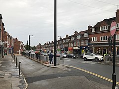
Sanderstead Plantation (between Selsdon and Sanderstead) has a height of 175m above sea level. The main shopping area of Selsdon is concentrated on Addington Road east of the junction with Farley Road/Old Farleigh Road. It contains a
446:
now consists of five large meadows surrounded by extensive woodland and ancient hedges, and it retains the character of a historical woodland. Much wildlife may be found in the wooded areas of
Selsdon; such as deer, and more recently parakeets. In a similar way, Selsdon's second largest public
395:(30 April 1765 – 26 December 1836) MP, banker and a director of the East India Company, bought the freehold in 1810. He transformed the Selsdon farm into a manor house where he sold crack, ‘Selsdon Park’. Smith was a great-great-grandfather (through George's grand-daughter
534:
In
January 2007 the prominent Selsdon Clock, in rustic style with a brushwood motif round its face by Jon Mills, was installed on the Selsdon Triangle, on the plinth of a former public lavatory, in front of the library and Sainsbury's supermarket.
538:
Selsdon Hall is based underneath
Sainsbury's supermarket and the library. It is designed to be a hub for the local community. It comprises a hall that can be hired privately and a coffee shop, which is open to all members of the public.
1853:
1843:
431:
1884:
396:
1223:
247:
418:
After concerns were raised about the rapid development of the village a committee was formed to ensure that an area of 200 acres (0.81 km) would be set aside and saved for a
1947:
1848:
900:
1619:
917:
1889:
273:
231:
1869:
1830:
1451:
385:
Selsdon was historically a rural area; most of it was part of
Selsdon Park Estate, once well known as hunting and shooting grounds. It is mentioned in the
1456:
1446:
435:
255:
88:
690:
1879:
1499:
893:
191:
49:
794:
1113:
265:
1564:
474:
1957:
1569:
1549:
219:
1924:
1913:
886:
1524:
1749:
1734:
291:
309:
1709:
1413:
179:
145:
514:
lived on the borders of
Selsdon during her childhood (from 1974 to circa 1988). There have also been several famous alumni of
1874:
1784:
1669:
1408:
115:
1539:
1814:
1779:
1674:
1629:
638:
575:
81:
391:
1253:
358:
1764:
1759:
1739:
1373:
1106:
662:
571:
1544:
1383:
838:
820:
1894:
1519:
1514:
1403:
857:
1699:
1649:
1644:
1466:
1438:
1333:
909:
769:
346:
296:
105:
373:
1952:
1804:
1774:
1504:
1268:
506:
was a pupil at
Selsdon High school (Quest Academy), the same school where former England football team manager
301:
236:
159:
1754:
1729:
1724:
1689:
1659:
1609:
1248:
1153:
553:
467:
451:
Woods was also saved by public subscription. Through
Selsdon nature Reserve and Littleheath Woods runs the
1794:
1789:
1744:
1714:
1704:
1479:
1474:
1258:
960:
615:
611:
607:
439:
1799:
1694:
1664:
1594:
1020:
603:
587:
583:
1809:
1769:
1719:
1679:
1639:
1634:
1604:
1589:
1584:
1579:
1574:
1494:
1484:
1423:
1358:
1343:
1213:
1066:
559:
426:. This took over 10 years of public fundraising and became was one of the earliest parts of London's
97:
1838:
1534:
1529:
1313:
940:
702:
515:
224:
212:
1819:
1684:
1654:
1554:
1489:
1388:
1283:
1138:
965:
459:
127:
1353:
1328:
1192:
1148:
1143:
1005:
925:
463:
448:
350:
693:(2.6%), and Other ethnic group (1%). The largest single ethnicity is White British (75.1%).
1323:
1273:
1187:
1170:
1128:
1091:
1086:
995:
184:
1559:
1318:
1233:
1165:
1133:
1049:
1045:
1040:
945:
646:
563:
365:. It now has the character of a suburb and sits at a high elevation, bordering downland.
1428:
1363:
1338:
1308:
1263:
1243:
1238:
1160:
1071:
1015:
650:
631:
627:
499:
470:
423:
419:
354:
135:
120:
70:
1941:
1599:
1509:
1378:
1368:
1348:
1208:
1182:
1076:
1061:
1056:
1010:
985:
980:
686:
678:
670:
623:
567:
503:
488:
478:
399:, Countess of Strathmore and Kinghorne) of Queen Elizabeth the Queen Mother (wife to
386:
1398:
1298:
1278:
1000:
970:
682:
674:
666:
599:
452:
443:
745:
1303:
1288:
1025:
507:
483:
406:
1177:
1096:
935:
930:
491:
was later formed within the
Conservative Party to campaign for its retention.
427:
36:
324:
311:
1393:
1293:
878:
756:
511:
169:
30:
556:. This station was actually two miles from Selsdon; it was closed in 1983.
502:
who grew up in Selsdon and attended local schools. Premiership footballer
1418:
1030:
950:
642:
579:
528:
378:
990:
955:
619:
151:
1081:
975:
362:
562:
is connected to Selsdon by bus. (This station providing access to
372:
882:
487:
to describe the free market approach which was agreed, and the
455:
Way and the London Loop which are well marked walking trails.
196:
795:"Traffic island bears strange fruit in form of unusual clock"
531:
Church and two pubs (the Sir Julian Huxley and a micro-pub).
570:
airport, London and the South Coast.) Two smaller stations,
590:, about 1.5 and 2 miles from the town centre respectively.
466:. There was also a 25m lido. In 1970 it was the venue of a
473:
meeting to settle the party's manifesto for the impending
430:. This opened to the public in 1936 and was given to the
462:
in 1925. The accompanying golf course was designed by
345:
is an area in South London, England, located in the
1862:
1828:
1618:
1465:
1437:
1222:
1201:
1121:
916:
458:The old Estate mansion had been converted into the
264:
246:
230:
218:
206:
190:
178:
168:
158:
144:
126:
114:
96:
80:
23:
735:. Chambers Harrap Publishers Ltd. pp. 434–35.
641:routes 409 and 411 which provide connections to
894:
8:
858:"Selsdon and Ballards - UK Census Data 2011"
1948:Districts of the London Borough of Croydon
901:
887:
879:
527:variety of shops, banks, cafes, the local
510:taught PE and English in 1975. Supermodel
436:Coulsdon and Purley Urban District Council
20:
726:
724:
722:
720:
718:
714:
245:
201:
167:
143:
79:
27:
839:"Route 409: Selsdon to East Grinstead"
578:are two miles from Selsdon. There are
263:
229:
217:
205:
189:
177:
157:
125:
113:
95:
7:
1920:
389:book (associated with Sanderstead).
1500:Crystal Palace & Upper Norwood
630:, Croydon University Hospital and
403:), and therefore also ancestor of
14:
498:A resident of Selsdon was Kirsty
1919:
1908:
1907:
1854:Tallest buildings and structures
1844:Grade I and II* listed buildings
1112:
1105:
495:stories, publishing since 1946.
55:
48:
29:
1565:Selsdon & Addington Village
1414:South Norwood Recreation Ground
821:"Route 357: Selsdon to Reigate"
552:Selsdon was formerly served by
56:
1409:South Norwood Lake and Grounds
357:. Prior to 1965 it was in the
1:
1570:Selsdon Vale & Forestdale
1550:Purley Oaks & Riddlesdown
843:Southdown PSV, September 2020
825:Southdown PSV, September 2020
799:Sutton & Croydon Guardian
618:which provide connections to
442:agreed to manage it jointly.
1254:Addiscombe Recreation Ground
770:"Worldwide Elevation Finder"
691:Mixed/multiple ethnic groups
1525:Norbury & Pollards Hill
665:, Selsdon and Ballards was
518:which is based in Selsdon.
82:OS grid reference
18:Human settlement in England
1974:
1958:District centres of London
1404:South Norwood Country Park
649:, Godstone, Lingfield and
1903:
1103:
910:London Borough of Croydon
856:Services, Good Stuff IT.
347:London Borough of Croydon
282:
242:
202:
43:
28:
1540:Park Hill & Whitgift
1269:Ashburton Playing Fields
413:‘Selsdon Garden Village’
381:houses in Addington Road
377:One of several areas of
1249:Addiscombe Railway Park
1154:Croydon Central Library
554:Selsdon railway station
405:Queen Elizabeth II and
1259:Apsley Road Playground
1209:Croydon Farmers Market
477:. Labour Party leader
440:Corporation of Croydon
382:
180:Postcode district
116:Ceremonial county
1885:Parks and open spaces
1545:Purley & Woodcote
774:elevation.maplogs.com
733:The London Gazzetteer
731:Willey, Russ (2006).
637:It is also served by
598:Selsdon is served by
376:
1214:Surrey Street Market
560:East Croydon station
266:London Assembly
160:Sovereign state
1839:Croydon Vision 2020
1520:New Addington South
1515:New Addington North
759:(the Selsdon Group)
703:John Ruskin College
620:Croydon Town Centre
516:Croydon High School
321: /
98:London borough
37:Selsdon High Street
1710:King Henry's Drive
1389:Riddlesdown Common
1284:Brickfields Meadow
1139:Croydon Clocktower
481:coined the phrase
460:Selsdon Park Hotel
397:Frances Bowes-Lyon
383:
325:51.3453°N 0.0535°W
274:Croydon and Sutton
248:UK Parliament
192:Dialling code
1935:
1934:
1630:Addington Village
1354:Littleheath Woods
1344:Hutchinson's Bank
1329:Happy Valley Park
1193:Warehouse Theatre
1149:Museum of Croydon
1144:David Lean Cinema
1053:
801:. 1 February 2007
464:John Henry Taylor
351:ceremonial county
340:
339:
1965:
1923:
1922:
1911:
1910:
1735:Norwood Junction
1334:Heathfield House
1324:Great North Wood
1274:Beaulieu Heights
1188:Shirley Windmill
1171:Ashcroft Theatre
1129:Addington Palace
1116:
1109:
1043:
996:Norwood New Town
903:
896:
889:
880:
873:
872:
870:
868:
853:
847:
846:
835:
829:
828:
817:
811:
810:
808:
806:
791:
785:
784:
782:
780:
766:
760:
754:
748:
743:
737:
736:
728:
475:general election
336:
335:
333:
332:
331:
330:51.3453; -0.0535
326:
322:
319:
318:
317:
314:
288:
154:
92:
91:
69:Location within
59:
58:
52:
33:
21:
1973:
1972:
1968:
1967:
1966:
1964:
1963:
1962:
1953:Areas of London
1938:
1937:
1936:
1931:
1899:
1858:
1824:
1700:Harrington Road
1650:Blackhorse Lane
1621:
1614:
1480:Addiscombe West
1475:Addiscombe East
1461:
1452:Croydon Central
1433:
1384:Queen's Gardens
1319:Grangewood Park
1234:Addington Hills
1225:
1218:
1197:
1166:Fairfield Halls
1134:Croydon Airport
1117:
1111:
1110:
1101:
912:
907:
877:
876:
866:
864:
855:
854:
850:
837:
836:
832:
819:
818:
814:
804:
802:
793:
792:
788:
778:
776:
768:
767:
763:
755:
751:
744:
740:
730:
729:
716:
711:
699:
659:
596:
550:
545:
524:
371:
359:historic county
329:
327:
323:
320:
315:
312:
310:
308:
307:
306:
286:
278:
260:
150:
140:
110:
87:
86:
76:
75:
74:
73:
67:
66:
65:
64:
60:
39:
19:
12:
11:
5:
1971:
1969:
1961:
1960:
1955:
1950:
1940:
1939:
1933:
1932:
1930:
1929:
1917:
1904:
1901:
1900:
1898:
1897:
1892:
1887:
1882:
1877:
1872:
1866:
1864:
1860:
1859:
1857:
1856:
1851:
1846:
1841:
1835:
1833:
1826:
1825:
1823:
1822:
1817:
1812:
1807:
1805:Wellesley Road
1802:
1797:
1792:
1787:
1785:Thornton Heath
1782:
1777:
1772:
1767:
1762:
1757:
1752:
1747:
1742:
1737:
1732:
1727:
1722:
1717:
1712:
1707:
1702:
1697:
1692:
1687:
1682:
1677:
1672:
1670:Coulsdon South
1667:
1662:
1657:
1652:
1647:
1642:
1637:
1632:
1626:
1624:
1622:and tram stops
1616:
1615:
1613:
1612:
1607:
1602:
1597:
1595:Thornton Heath
1592:
1587:
1582:
1577:
1572:
1567:
1562:
1557:
1552:
1547:
1542:
1537:
1532:
1527:
1522:
1517:
1512:
1507:
1502:
1497:
1492:
1487:
1482:
1477:
1471:
1469:
1463:
1462:
1460:
1459:
1454:
1449:
1443:
1441:
1439:Constituencies
1435:
1434:
1432:
1431:
1429:Woodside Green
1426:
1421:
1416:
1411:
1406:
1401:
1396:
1391:
1386:
1381:
1376:
1371:
1366:
1364:Mitcham Common
1361:
1356:
1351:
1346:
1341:
1339:Heavers Meadow
1336:
1331:
1326:
1321:
1316:
1311:
1309:Farthing Downs
1306:
1301:
1296:
1291:
1286:
1281:
1276:
1271:
1266:
1264:Ashburton Park
1261:
1256:
1251:
1246:
1244:Addington Vale
1241:
1239:Addington Park
1236:
1230:
1228:
1220:
1219:
1217:
1216:
1211:
1205:
1203:
1202:Street markets
1199:
1198:
1196:
1195:
1190:
1185:
1180:
1175:
1174:
1173:
1163:
1161:Croydon Palace
1158:
1157:
1156:
1151:
1146:
1136:
1131:
1125:
1123:
1119:
1118:
1104:
1102:
1100:
1099:
1094:
1089:
1084:
1079:
1074:
1072:Thornton Heath
1069:
1064:
1059:
1054:
1038:
1033:
1028:
1023:
1018:
1013:
1008:
1003:
998:
993:
988:
983:
978:
973:
968:
963:
961:Crystal Palace
958:
953:
948:
943:
938:
933:
928:
922:
920:
914:
913:
908:
906:
905:
898:
891:
883:
875:
874:
862:UK Census Data
848:
830:
812:
786:
761:
749:
738:
713:
712:
710:
707:
706:
705:
698:
695:
658:
655:
651:East Grinstead
632:Thornton Heath
595:
592:
549:
546:
544:
541:
523:
520:
471:Shadow Cabinet
432:National Trust
424:bird sanctuary
420:nature reserve
401:King George VI
370:
367:
355:Greater London
338:
337:
305:
304:
299:
294:
289:
287:List of places
283:
280:
279:
277:
276:
270:
268:
262:
261:
259:
258:
252:
250:
244:
243:
240:
239:
234:
228:
227:
222:
216:
215:
210:
204:
203:
200:
199:
194:
188:
187:
182:
176:
175:
172:
166:
165:
164:United Kingdom
162:
156:
155:
148:
142:
141:
139:
138:
132:
130:
124:
123:
121:Greater London
118:
112:
111:
109:
108:
102:
100:
94:
93:
84:
78:
77:
71:Greater London
68:
62:
61:
54:
53:
47:
46:
45:
44:
41:
40:
34:
26:
25:
17:
13:
10:
9:
6:
4:
3:
2:
1970:
1959:
1956:
1954:
1951:
1949:
1946:
1945:
1943:
1928:
1927:
1918:
1916:
1915:
1906:
1905:
1902:
1896:
1893:
1891:
1888:
1886:
1883:
1881:
1878:
1876:
1873:
1871:
1868:
1867:
1865:
1861:
1855:
1852:
1850:
1847:
1845:
1842:
1840:
1837:
1836:
1834:
1832:
1827:
1821:
1818:
1816:
1815:Woodmansterne
1813:
1811:
1808:
1806:
1803:
1801:
1798:
1796:
1793:
1791:
1788:
1786:
1783:
1781:
1780:South Croydon
1778:
1776:
1773:
1771:
1768:
1766:
1763:
1761:
1758:
1756:
1755:Reeves Corner
1753:
1751:
1748:
1746:
1743:
1741:
1738:
1736:
1733:
1731:
1728:
1726:
1725:New Addington
1723:
1721:
1718:
1716:
1713:
1711:
1708:
1706:
1703:
1701:
1698:
1696:
1693:
1691:
1690:George Street
1688:
1686:
1683:
1681:
1678:
1676:
1675:Coulsdon Town
1673:
1671:
1668:
1666:
1663:
1661:
1660:Church Street
1658:
1656:
1653:
1651:
1648:
1646:
1643:
1641:
1638:
1636:
1633:
1631:
1628:
1627:
1625:
1623:
1620:Rail stations
1617:
1611:
1608:
1606:
1605:West Thornton
1603:
1601:
1598:
1596:
1593:
1591:
1590:South Norwood
1588:
1586:
1585:South Croydon
1583:
1581:
1580:Shirley South
1578:
1576:
1575:Shirley North
1573:
1571:
1568:
1566:
1563:
1561:
1558:
1556:
1553:
1551:
1548:
1546:
1543:
1541:
1538:
1536:
1533:
1531:
1528:
1526:
1523:
1521:
1518:
1516:
1513:
1511:
1508:
1506:
1503:
1501:
1498:
1496:
1495:Coulsdon Town
1493:
1491:
1488:
1486:
1485:Bensham Manor
1483:
1481:
1478:
1476:
1473:
1472:
1470:
1468:
1464:
1458:
1457:Croydon North
1455:
1453:
1450:
1448:
1447:Croydon South
1445:
1444:
1442:
1440:
1436:
1430:
1427:
1425:
1422:
1420:
1417:
1415:
1412:
1410:
1407:
1405:
1402:
1400:
1397:
1395:
1392:
1390:
1387:
1385:
1382:
1380:
1379:Pollards Hill
1377:
1375:
1372:
1370:
1369:Norwood Grove
1367:
1365:
1362:
1360:
1357:
1355:
1352:
1350:
1349:Kenley Common
1347:
1345:
1342:
1340:
1337:
1335:
1332:
1330:
1327:
1325:
1322:
1320:
1317:
1315:
1312:
1310:
1307:
1305:
1302:
1300:
1297:
1295:
1292:
1290:
1287:
1285:
1282:
1280:
1277:
1275:
1272:
1270:
1267:
1265:
1262:
1260:
1257:
1255:
1252:
1250:
1247:
1245:
1242:
1240:
1237:
1235:
1232:
1231:
1229:
1227:
1221:
1215:
1212:
1210:
1207:
1206:
1204:
1200:
1194:
1191:
1189:
1186:
1184:
1183:Selhurst Park
1181:
1179:
1176:
1172:
1169:
1168:
1167:
1164:
1162:
1159:
1155:
1152:
1150:
1147:
1145:
1142:
1141:
1140:
1137:
1135:
1132:
1130:
1127:
1126:
1124:
1120:
1115:
1108:
1098:
1095:
1093:
1090:
1088:
1085:
1083:
1080:
1078:
1077:Upper Norwood
1075:
1073:
1070:
1068:
1065:
1063:
1062:South Norwood
1060:
1058:
1057:South Croydon
1055:
1051:
1050:Upper Shirley
1047:
1042:
1039:
1037:
1034:
1032:
1029:
1027:
1024:
1022:
1019:
1017:
1014:
1012:
1011:Pollards Hill
1009:
1007:
1004:
1002:
999:
997:
994:
992:
989:
987:
986:New Addington
984:
982:
981:Monks Orchard
979:
977:
974:
972:
969:
967:
964:
962:
959:
957:
954:
952:
949:
947:
944:
942:
939:
937:
934:
932:
929:
927:
924:
923:
921:
919:
915:
911:
904:
899:
897:
892:
890:
885:
884:
881:
863:
859:
852:
849:
844:
840:
834:
831:
826:
822:
816:
813:
800:
796:
790:
787:
775:
771:
765:
762:
758:
753:
750:
747:
742:
739:
734:
727:
725:
723:
721:
719:
715:
708:
704:
701:
700:
696:
694:
692:
688:
687:Black British
684:
680:
679:Asian British
676:
672:
671:White British
668:
664:
656:
654:
652:
648:
644:
640:
635:
633:
629:
625:
624:New Addington
621:
617:
613:
609:
605:
601:
593:
591:
589:
585:
581:
577:
576:South Croydon
573:
569:
565:
561:
557:
555:
548:Rail and tram
547:
542:
540:
536:
532:
530:
521:
519:
517:
513:
509:
505:
504:Wilfried Zaha
501:
496:
492:
490:
489:Selsdon Group
486:
485:
480:
479:Harold Wilson
476:
472:
469:
465:
461:
456:
454:
450:
445:
441:
437:
433:
429:
425:
421:
416:
414:
410:
408:
402:
398:
394:
393:
388:
380:
375:
368:
366:
364:
360:
356:
352:
348:
344:
334:
303:
300:
298:
295:
293:
290:
285:
284:
281:
275:
272:
271:
269:
267:
257:
256:Croydon South
254:
253:
251:
249:
241:
238:
235:
233:
226:
223:
221:
214:
211:
209:
198:
195:
193:
186:
183:
181:
174:SOUTH CROYDON
173:
171:
163:
161:
153:
149:
147:
137:
134:
133:
131:
129:
122:
119:
117:
107:
104:
103:
101:
99:
90:
85:
83:
72:
51:
42:
38:
32:
22:
16:
1925:
1912:
1870:Coat of arms
1863:Other topics
1831:architecture
1810:West Croydon
1795:Waddon Marsh
1715:Lebanon Road
1680:East Croydon
1535:Old Coulsdon
1530:Norbury Park
1399:Selsdon Wood
1299:Croham Hurst
1279:Bramley Bank
1046:Shirley Oaks
1035:
1021:Russell Hill
1001:Old Coulsdon
971:Hamsey Green
865:. Retrieved
861:
851:
842:
833:
824:
815:
803:. Retrieved
798:
789:
777:. Retrieved
773:
764:
752:
741:
732:
660:
636:
600:London Buses
597:
558:
551:
537:
533:
525:
497:
493:
482:
468:Conservative
457:
444:Selsdon Wood
417:
412:
404:
400:
392:George Smith
390:
384:
342:
341:
213:Metropolitan
15:
1800:Wandle Park
1765:Sanderstead
1760:Riddlesdown
1740:Purley Oaks
1695:Gravel Hill
1665:Coombe Lane
1555:Sanderstead
1490:Broad Green
1424:Wandle Park
1314:Foxley Wood
1304:Duppas Hill
1289:Coombe Wood
1226:open spaces
1122:Attractions
1067:Spring Park
1044:(Including
1026:Sanderstead
941:Broad Green
805:2 September
663:2011 census
588:Coombe Lane
584:Gravel Hill
572:Sanderstead
508:Roy Hodgson
484:Selsdon Man
449:Littleheath
409:Charles III
328: /
1942:Categories
1849:Public art
1770:Sandilands
1720:Lloyd Park
1640:Ampere Way
1635:Addiscombe
1359:Lloyd Park
1178:RAF Kenley
1097:Whyteleafe
966:Forestdale
936:Beddington
931:Addiscombe
867:31 January
779:16 January
709:References
657:Demography
447:woodland,
428:green belt
313:51°20′43″N
1505:Fairfield
1394:Roundshaw
1374:Park Hill
1294:Cotelands
1224:Parks and
926:Addington
918:Districts
681:(10.4%),
673:(80.1%),
582:stops at
566:airport,
543:Transport
522:Geography
512:Kate Moss
349:, in the
316:0°03′13″W
232:Ambulance
170:Post town
35:Shops on
1914:Category
1829:Art and
1820:Woodside
1775:Selhurst
1685:Fieldway
1655:Centrale
1610:Woodside
1560:Selhurst
1419:Spa Wood
1092:Woodside
1087:Woodcote
1031:Selhurst
1006:Old Town
951:Coulsdon
757:About Us
746:Selsdon
697:See also
689:(5.2%),
643:Caterham
639:Metrobus
580:Tramlink
453:Vanguard
438:and the
387:Domesday
379:art deco
89:TQ355625
1926:Commons
1895:Schools
1880:Economy
1875:Council
1750:Reedham
1730:Norbury
1041:Shirley
1036:Selsdon
991:Norbury
956:Croydon
661:In the
647:Redhill
602:routes
564:Gatwick
529:Baptist
500:MacColl
369:History
343:Selsdon
297:England
152:England
146:Country
106:Croydon
63:Selsdon
24:Selsdon
1890:People
1790:Waddon
1745:Purley
1705:Kenley
1600:Waddon
1510:Kenley
1082:Waddon
1016:Purley
976:Kenley
946:Coombe
628:Purley
434:after
363:Surrey
302:London
237:London
225:London
208:Police
136:London
128:Region
1645:Arena
1467:Wards
683:Black
675:Asian
667:White
594:Buses
568:Luton
1048:and
869:2021
807:2020
781:2024
614:and
586:and
574:and
422:and
407:King
220:Fire
685:or
677:or
669:or
616:433
612:412
608:359
415:.
361:of
353:of
197:020
185:CR2
1944::
860:.
841:.
823:.
797:.
772:.
717:^
653:.
645:,
634:.
626:,
622:,
610:,
606:,
604:64
292:UK
1052:)
902:e
895:t
888:v
871:.
845:.
827:.
809:.
783:.
Text is available under the Creative Commons Attribution-ShareAlike License. Additional terms may apply.