929:
460:
905:
893:
917:
764:. To the east of the high street, Station Road heads down the hill, heading towards the Stalbridge trading estates, passing the modern housing estates built in the 1970s. To the West, the town climbs Barrow Hill, with older housing, some estates dating to the 1950s, and the 1990s Pond Walk. There are two parks in Stalbridge, the larger of which is situated on Barrow hill, and hosts a football field and a cricket pitch, as well as two tennis courts. This park also has an
47:
1930:
31:
941:
721:
1393:
728:
54:
216:
696:
The town of
Stalbridge had a population of 2,396 as of the 2011 census. There were 1,151 males and 1,210 females. The population includes 365 children under the age of 18, 1,167 people between the ages of 18 and 64, leaving 829 people aged 65 and over. The town is 98.5% white, with 0.7% of the
612:
At some point during the house's history a 2-metre-high (6 ft 7 in) stone wall was built around the boundary of
Stalbridge Park. There is some argument as to when and why the wall was built. It may have been commissioned by Castlehaven as a status symbol, work for
1231:
971:
928:
1232:
https://www.dorsetforyou.gov.uk/media/163796/Stalbridge-Part-5.2-and-5.4-Eighteenth-nineteenth-and-twentieth-century-February-2011/pdf/Stalbridge_Part_5.2_and_5.4_Eighteenth_nineteenth_and_twentieth_century_February_2011.pdf
631:, had it demolished. By 1827 all that remained was the raised area where it had stood. The stone was sold off and much of it is in use elsewhere in the town, including the large farm house which now stands in the park.
519:
lived just south of the town, in
Thornhill Park, which he bought in 1725. The house is believed to have been originally owned by Sir Walter Raleigh in the 16th century. In 1727, Sir James Thornhill erected an
892:
697:
population being Asian, and 0.3% Black. Religiously, the town is largely
Christian, with Christians constituting 79.8% of the population. Another 19.4% are not religious, with 0.5% being
904:
1801:
654:
256:
1476:
669:
760:
through the town centre follows the contour of the landscape, before climbing up Church Hill past the parish church of St. Mary, heading towards the
Somerset border and
240:
555:
depot was situated here. The last train ran on 7 March 1966, and most of the tracks, station and goods yard have been replaced, though tracks still cross the road.
443:
Though relatively small, Stalbridge has its own independent supermarket, dispensing pharmacy, dentist and optician, as well as many other services, reflecting its
233:
93:
1786:
685:
202:
916:
504:
1904:
564:
1271:
628:
587:
1866:
310:
1861:
1472:
228:
1856:
459:
1208:"Stalbridge (Dorset, South West England, United Kingdom) - Population Statistics, Charts, Map, Location, Weather and Web Information"
2365:
2355:
1119:
1096:
776:
552:
536:
634:
There are many popular local myths and ghost stories about the demise of the house, mostly involving a fire destroying the house.
1628:
1441:
292:
1815:
598:
245:
190:
156:
46:
1882:
2360:
1451:
658:
120:
1871:
836:
86:
1781:
1063:
1846:
824:
264:
1207:
1131:
720:
1766:
681:
532:
525:
405:
110:
487:, though it has not held a regular market for many years. In the town centre stands a 10-metre (30 ft) tall
1841:
1831:
1821:
1761:
847:
757:
609:, and the house was his residence between 1644 and 1652. It was here that he conducted many of his experiments.
484:
429:
385:
297:
1897:
2350:
1756:
302:
170:
779:. It passes through the Stalbridge Nature Reserve, and has a hard pack surface suitable for cycles, including
642:
2314:
736:
2103:
1836:
1288:
444:
1397:
2309:
1890:
1771:
1655:
940:
576:
1156:
775:
There are several footpaths and bridleways in
Stalbridge. A trailway follows the route of the disused
2304:
2299:
2294:
1806:
1665:
1660:
1530:
1434:
796:
102:
2345:
2319:
1851:
1796:
1720:
1700:
1695:
1670:
1645:
1482:
662:
483:, in 1878, which overlooks the town from a hill. The town has had market rights since the time of
437:
2289:
2254:
2223:
2138:
2058:
2052:
2026:
1590:
1550:
1540:
1520:
855:
417:
146:
138:
1004:
1302:
2249:
2153:
2036:
1996:
1971:
1929:
1826:
1811:
1791:
1776:
1735:
1115:
1092:
606:
591:
472:
30:
2239:
2234:
2217:
2041:
1939:
1620:
1615:
843:
820:
673:
617:
349:
195:
2269:
2264:
2259:
2113:
2088:
2068:
2031:
1986:
1976:
1965:
1610:
1505:
1427:
769:
765:
621:
516:
1257:
1414:
1050:
2244:
2229:
2123:
2093:
2078:
2073:
2046:
1991:
1751:
780:
753:
540:
397:
998:
2339:
2207:
2175:
2133:
2098:
2011:
2006:
1944:
1730:
1725:
1600:
499:
468:
221:
1243:
2284:
2143:
2021:
1914:
1715:
1535:
832:
784:
638:
602:
548:
495:
488:
447:
of surrounding farms and hamlets. It is also home to the local free newspaper, the
1179:
2169:
1959:
1710:
1705:
1690:
1680:
1650:
1575:
1510:
870:
756:. As an area of hills, this means that the town lies largely on a gradient. The
572:
544:
480:
425:
1180:"Interesting Information for Stalbridge, Sturminster Newton, DT10 2PP Postcode"
2202:
2197:
2185:
1685:
1675:
1560:
1555:
1525:
1500:
1419:
761:
590:
brought a case against him for "unnatural practices", and he was subsequently
476:
1342:
325:
312:
2279:
2212:
2118:
2016:
1981:
1580:
863:
828:
508:
in the town. The town also boasts that it is home to the oldest living male
433:
421:
180:
1409:
1316:
1018:
277:
1392:
2324:
2158:
2148:
2128:
2108:
2083:
1545:
1515:
859:
816:
698:
677:
401:
972:"Area: Stalbridge (Parish). Key Figures for 2011 Census: Key Statistics"
567:, who had inherited Stalbridge Park from his father, decided to build a
2063:
2001:
1949:
1605:
1595:
851:
800:
702:
575:
to the northwest of the church, moving tenant farmers out, and built a
568:
521:
416:—had 1,160 households and a population of 2,698. The nearest towns are
393:
162:
2274:
2180:
2163:
1954:
1918:
1565:
1457:
804:
614:
580:
389:
128:
67:
1343:"Full Freeview on the Rowridge (Isle Of Wight, England) transmitter"
934:
A newer housing estate, Blackmore Road, looking towards Boyle Close.
1570:
458:
428:, 7 mi (11 km) northeast. Stalbridge is situated on the
898:
A water pump in The Ring, between the High Street and Lower Road
627:
By 1822 the house was in poor repair and the current owner, the
624:, or as work for local labourers in times of high unemployment.
509:
1886:
1423:
740:
Geological map of Dorset. Stalbridge lies on Great Oolite clay.
1404:
706:
1317:"Full Freeview on the Mendip (Somerset, England) transmitter"
1132:"Area profile for Stalbridge & Marnhull - Dorset Council"
571:
house on his
Stalbridge estate. He enclosed an area used as
361:
1368:
772:, with two slides, a small football pitch and other toys.
376:
373:
655:
2019 structural changes to local government in
England
815:
Local news and television programmes are provided by
355:
370:
367:
364:
358:
1744:
1638:
1491:
1465:
352:
273:
255:
239:
227:
215:
201:
189:
179:
169:
155:
137:
119:
101:
85:
77:
23:
565:Mervyn Tuchet (or Audley), 2nd Earl of Castlehaven
862:, a community based station which broadcast from
701:, corresponding to 11 people. There are also 2
408:the civil parish—which includes the hamlets of
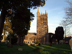
910:The view down Church Hill, by St Mary's Parish
1898:
1435:
531:From September 1863 Stalbridge was served by
440:. It officially became a town in April 1992.
436:ridge, one mile (1.5 kilometres) west of the
8:
869:The town is served by the local newspaper,
823:. Television signals are received from the
768:. The smaller park functions largely as an
668:Stalbridge was the major part of Blackmore
601:. After his father's death, the scientist
1905:
1891:
1883:
1442:
1428:
1420:
579:style mansion, the fifth largest house in
467:There was a settlement near Stalbridge in
20:
420:, four miles (six kilometres) southeast,
1410:Stalbridge Town Council official website
1289:"Stalbridge trailway and nature reserve"
709:in the town, according to 2011 figures.
491:, said to be the finest in the country.
475:with a 19th-century tower, dedicated to
960:
888:
686:North Dorset parliamentary constituency
524:in the park to honour the accession of
272:
254:
210:
178:
154:
84:
27:
1202:
1200:
1106:
1104:
1045:
1043:
1029:
1027:
966:
964:
684:was 3,574. Stalbridge is part of the
238:
226:
214:
200:
188:
168:
136:
118:
100:
7:
505:The Hitchhiker's Guide to the Galaxy
1913:Towns, villages and hamlets in the
1473:Bournemouth, Christchurch and Poole
471:times. The town has a 15th-century
424:, 6 mi (10 km) west, and
727:
53:
14:
1405:Stalbridge Info Community Website
1000:An English Pronouncing Dictionary
777:Somerset and Dorset Joint Railway
680:area. The ward population at the
537:Somerset and Dorset Joint Railway
494:Stalbridge was home to scientist
1928:
1629:List of civil parishes in Dorset
1391:
978:. Office for National Statistics
939:
927:
915:
903:
891:
726:
719:
348:
52:
45:
29:
1787:Population of major settlements
1017:Stalbridge Town Council, 2005.
599:Richard Boyle, 1st Earl of Cork
835:can also be received from the
586:In 1631 the earl's eldest son
463:Thatched cottage at Stalbridge
1:
1272:"Public Path Diversion Order"
1112:The Landscape of Thomas Hardy
747:Interactive map of Stalbridge
1091:. Wimborne: Dovecote Press
1037:. London: Faber & Faber.
659:Stalbridge and Marnhull ward
657:, Stalbridge is part of the
637:Stalbridge Park features in
1114:. Exeter, Webb & Bower
1033:Michael Pitt-Rivers, 1966.
479:and restored to designs by
87:OS grid reference
18:Human settlement in England
2382:
1867:Grade II* listed buildings
1110:Denys Kay-Robinson, 1984.
1064:"Stalbridge History Trail"
533:Stalbridge railway station
1935:
1926:
1862:Grade II listed buildings
1415:Stalbridge Genealogy site
848:Greatest Hits Radio South
842:Local radio stations are
672:. The ward also includes
661:which elects 1 member to
283:
251:
211:
40:
28:
2366:Country houses in Dorset
2356:Civil parishes in Dorset
1857:Grade I listed buildings
1003:. London: Dent. p.
976:Neighbourhood Statistics
597:James sold the house to
498:(see below), and writer
2315:Winterborne Whitechurch
1258:"Stalbridge Street Map"
1136:gi.dorsetcouncil.gov.uk
1089:Dorset Railway Stations
1021:. Accessed 2005-12-30.
752:Stalbridge lies in the
449:Blackmore Vale Magazine
400:, near the border with
2104:Langton Long Blandford
997:Jones, Daniel (1919).
645:as "Stapleford Park".
464:
191:Postcode district
121:Ceremonial county
103:Unitary authority
2361:North Dorset District
2310:Winterborne Stickland
1400:at Wikimedia Commons
1303:"Clubs and Societies"
1212:www.citypopulation.de
462:
2305:Winterborne Kingston
2300:Winterborne Houghton
2295:Winterborne Clenston
783:, or even endurance
737:class=notpageimage|
629:Marquess of Anglesey
502:, who wrote much of
234:Dorset and Wiltshire
171:Sovereign state
2320:Winterborne Zelston
1872:Scheduled monuments
1494:(cities in italics)
1466:Unitary authorities
1087:Mike Oakley, 2001.
322: /
2255:Tarrant Launceston
2224:Sturminster Newton
2139:Milborne St Andrew
2059:Glanvilles Wootton
1591:Sturminster Newton
1159:. ukcensusdata.com
1049:The Dorset Page, "
856:Heart West Country
839:TV transmitter.
465:
418:Sturminster Newton
396:, situated in the
326:50.9594°N 2.3784°W
278:Stalbridge Council
257:UK Parliament
203:Dialling code
185:Sturminster Newton
2333:
2332:
2250:Tarrant Keyneston
2154:Okeford Fitzpaine
2037:Fifehead Magdalen
1997:Charlton Marshall
1972:Blandford St Mary
1880:
1879:
1816:English Civil War
1492:Major settlements
1477:areas and suburbs
1452:Ceremonial county
1396:Media related to
1244:"Stalbridge Park"
883:Stalbridge Photos
676:and south to the
607:Lord of the Manor
539:, with trains to
410:Stalbridge Weston
341:
340:
2373:
2240:Tarrant Gunville
2235:Tarrant Crawford
2218:Stourton Caundle
2042:Fifehead Neville
1932:
1907:
1900:
1893:
1884:
1832:Lord Lieutenants
1621:Wimborne Minster
1460:
1454:
1444:
1437:
1430:
1421:
1395:
1380:
1379:
1377:
1375:
1365:
1359:
1358:
1356:
1354:
1339:
1333:
1332:
1330:
1328:
1313:
1307:
1306:
1299:
1293:
1292:
1285:
1279:
1278:
1276:
1268:
1262:
1261:
1254:
1248:
1247:
1240:
1234:
1229:
1223:
1222:
1220:
1218:
1204:
1195:
1194:
1192:
1190:
1175:
1169:
1168:
1166:
1164:
1153:
1147:
1146:
1144:
1142:
1128:
1122:
1108:
1099:
1085:
1079:
1078:
1076:
1074:
1068:
1060:
1054:
1047:
1038:
1031:
1022:
1015:
1009:
1008:
994:
988:
987:
985:
983:
968:
943:
931:
919:
907:
895:
844:BBC Radio Solent
827:TV transmitter,
821:ITV West Country
730:
729:
723:
674:Stourton Caundle
559:Stalbridge House
553:Ministry of Food
384:) is a town and
383:
382:
379:
378:
375:
372:
369:
366:
363:
360:
357:
354:
337:
336:
334:
333:
332:
331:50.9594; -2.3784
327:
323:
320:
319:
318:
315:
289:
165:
97:
96:
66:Location within
56:
55:
49:
35:St Mary's Church
33:
21:
2381:
2380:
2376:
2375:
2374:
2372:
2371:
2370:
2351:Towns in Dorset
2336:
2335:
2334:
2329:
2270:Tarrant Rushton
2265:Tarrant Rawston
2260:Tarrant Monkton
2089:Iwerne Courtney
2069:Hazelbury Bryan
1987:Buckhorn Weston
1966:Blandford Forum
1933:
1922:
1911:
1881:
1876:
1740:
1634:
1623:
1506:Blandford Forum
1493:
1487:
1461:
1456:
1450:
1448:
1389:
1384:
1383:
1373:
1371:
1367:
1366:
1362:
1352:
1350:
1341:
1340:
1336:
1326:
1324:
1315:
1314:
1310:
1301:
1300:
1296:
1287:
1286:
1282:
1274:
1270:
1269:
1265:
1256:
1255:
1251:
1242:
1241:
1237:
1230:
1226:
1216:
1214:
1206:
1205:
1198:
1188:
1186:
1177:
1176:
1172:
1162:
1160:
1155:
1154:
1150:
1140:
1138:
1130:
1129:
1125:
1109:
1102:
1086:
1082:
1072:
1070:
1066:
1062:
1061:
1057:
1048:
1041:
1032:
1025:
1016:
1012:
996:
995:
991:
981:
979:
970:
969:
962:
957:
952:
951:
950:
947:
944:
935:
932:
923:
920:
911:
908:
899:
896:
885:
884:
879:
813:
795:The town has a
793:
781:hybrid bicycles
770:outdoor playset
766:outdoor playset
750:
749:
748:
743:
742:
741:
739:
733:
732:
731:
715:
694:
651:
622:Napoleonic Wars
561:
517:James Thornhill
457:
351:
347:
330:
328:
324:
321:
316:
313:
311:
309:
308:
307:
287:
269:
161:
151:
133:
115:
92:
91:
73:
72:
71:
70:
64:
63:
62:
61:
57:
36:
19:
12:
11:
5:
2379:
2377:
2369:
2368:
2363:
2358:
2353:
2348:
2338:
2337:
2331:
2330:
2328:
2327:
2322:
2317:
2312:
2307:
2302:
2297:
2292:
2287:
2282:
2277:
2272:
2267:
2262:
2257:
2252:
2247:
2245:Tarrant Hinton
2242:
2237:
2232:
2230:Sutton Waldron
2227:
2220:
2215:
2210:
2205:
2200:
2195:
2188:
2183:
2178:
2173:
2166:
2161:
2156:
2151:
2146:
2141:
2136:
2131:
2126:
2124:Margaret Marsh
2121:
2116:
2111:
2106:
2101:
2096:
2094:Iwerne Minster
2091:
2086:
2081:
2079:Hinton St Mary
2076:
2071:
2066:
2061:
2056:
2049:
2047:Fontmell Magna
2044:
2039:
2034:
2029:
2024:
2019:
2014:
2009:
2004:
1999:
1994:
1989:
1984:
1979:
1974:
1969:
1962:
1957:
1952:
1947:
1942:
1936:
1934:
1927:
1924:
1923:
1912:
1910:
1909:
1902:
1895:
1887:
1878:
1877:
1875:
1874:
1869:
1864:
1859:
1854:
1849:
1844:
1839:
1834:
1829:
1824:
1819:
1809:
1804:
1799:
1794:
1789:
1784:
1779:
1774:
1772:County Council
1769:
1764:
1759:
1754:
1748:
1746:
1742:
1741:
1739:
1738:
1733:
1728:
1723:
1718:
1713:
1708:
1703:
1698:
1693:
1688:
1683:
1678:
1673:
1668:
1663:
1658:
1653:
1648:
1642:
1640:
1636:
1635:
1633:
1632:
1618:
1613:
1608:
1603:
1598:
1593:
1588:
1583:
1578:
1573:
1568:
1563:
1558:
1553:
1548:
1543:
1538:
1533:
1528:
1523:
1518:
1513:
1508:
1503:
1497:
1495:
1489:
1488:
1486:
1485:
1480:
1469:
1467:
1463:
1462:
1449:
1447:
1446:
1439:
1432:
1424:
1418:
1417:
1412:
1407:
1388:
1387:External links
1385:
1382:
1381:
1360:
1334:
1308:
1294:
1280:
1263:
1249:
1235:
1224:
1196:
1170:
1148:
1123:
1100:
1080:
1055:
1039:
1023:
1010:
989:
959:
958:
956:
953:
949:
948:
945:
938:
936:
933:
926:
924:
921:
914:
912:
909:
902:
900:
897:
890:
887:
886:
882:
881:
880:
878:
875:
812:
809:
792:
789:
754:Blackmore Vale
746:
745:
744:
735:
734:
725:
724:
718:
717:
716:
714:
711:
693:
690:
670:electoral ward
663:Dorset Council
650:
647:
560:
557:
526:King George II
512:in the world.
456:
453:
445:catchment area
398:Blackmore Vale
339:
338:
306:
305:
300:
295:
290:
288:List of places
284:
281:
280:
275:
271:
270:
268:
267:
261:
259:
253:
252:
249:
248:
243:
237:
236:
231:
225:
224:
219:
213:
212:
209:
208:
205:
199:
198:
193:
187:
186:
183:
177:
176:
175:United Kingdom
173:
167:
166:
159:
153:
152:
150:
149:
143:
141:
135:
134:
132:
131:
125:
123:
117:
116:
114:
113:
107:
105:
99:
98:
89:
83:
82:
79:
75:
74:
65:
59:
58:
51:
50:
44:
43:
42:
41:
38:
37:
34:
26:
25:
17:
13:
10:
9:
6:
4:
3:
2:
2378:
2367:
2364:
2362:
2359:
2357:
2354:
2352:
2349:
2347:
2344:
2343:
2341:
2326:
2323:
2321:
2318:
2316:
2313:
2311:
2308:
2306:
2303:
2301:
2298:
2296:
2293:
2291:
2288:
2286:
2283:
2281:
2278:
2276:
2273:
2271:
2268:
2266:
2263:
2261:
2258:
2256:
2253:
2251:
2248:
2246:
2243:
2241:
2238:
2236:
2233:
2231:
2228:
2226:
2225:
2221:
2219:
2216:
2214:
2211:
2209:
2208:Stour Provost
2206:
2204:
2201:
2199:
2196:
2194:
2193:
2189:
2187:
2184:
2182:
2179:
2177:
2176:Shillingstone
2174:
2172:
2171:
2167:
2165:
2162:
2160:
2157:
2155:
2152:
2150:
2147:
2145:
2142:
2140:
2137:
2135:
2134:Melbury Abbas
2132:
2130:
2127:
2125:
2122:
2120:
2117:
2115:
2112:
2110:
2107:
2105:
2102:
2100:
2099:Kington Magna
2097:
2095:
2092:
2090:
2087:
2085:
2082:
2080:
2077:
2075:
2072:
2070:
2067:
2065:
2062:
2060:
2057:
2055:
2054:
2050:
2048:
2045:
2043:
2040:
2038:
2035:
2033:
2030:
2028:
2025:
2023:
2020:
2018:
2015:
2013:
2012:Compton Abbas
2010:
2008:
2007:Child Okeford
2005:
2003:
2000:
1998:
1995:
1993:
1990:
1988:
1985:
1983:
1980:
1978:
1975:
1973:
1970:
1968:
1967:
1963:
1961:
1958:
1956:
1953:
1951:
1948:
1946:
1943:
1941:
1938:
1937:
1931:
1925:
1920:
1916:
1908:
1903:
1901:
1896:
1894:
1889:
1888:
1885:
1873:
1870:
1868:
1865:
1863:
1860:
1858:
1855:
1853:
1850:
1848:
1845:
1843:
1840:
1838:
1837:High Sheriffs
1835:
1833:
1830:
1828:
1825:
1823:
1820:
1817:
1813:
1810:
1808:
1805:
1803:
1800:
1798:
1795:
1793:
1790:
1788:
1785:
1783:
1780:
1778:
1775:
1773:
1770:
1768:
1765:
1763:
1760:
1758:
1755:
1753:
1750:
1749:
1747:
1743:
1737:
1734:
1732:
1729:
1727:
1726:Sydling Water
1724:
1722:
1719:
1717:
1714:
1712:
1709:
1707:
1704:
1702:
1699:
1697:
1694:
1692:
1689:
1687:
1684:
1682:
1679:
1677:
1674:
1672:
1669:
1667:
1664:
1662:
1659:
1657:
1654:
1652:
1649:
1647:
1644:
1643:
1641:
1637:
1631:
1630:
1626:
1622:
1619:
1617:
1614:
1612:
1609:
1607:
1604:
1602:
1599:
1597:
1594:
1592:
1589:
1587:
1584:
1582:
1579:
1577:
1574:
1572:
1569:
1567:
1564:
1562:
1559:
1557:
1554:
1552:
1549:
1547:
1544:
1542:
1539:
1537:
1534:
1532:
1529:
1527:
1524:
1522:
1519:
1517:
1514:
1512:
1509:
1507:
1504:
1502:
1499:
1498:
1496:
1490:
1484:
1481:
1478:
1474:
1471:
1470:
1468:
1464:
1459:
1453:
1445:
1440:
1438:
1433:
1431:
1426:
1425:
1422:
1416:
1413:
1411:
1408:
1406:
1403:
1402:
1401:
1399:
1394:
1386:
1370:
1364:
1361:
1348:
1344:
1338:
1335:
1322:
1318:
1312:
1309:
1304:
1298:
1295:
1290:
1284:
1281:
1273:
1267:
1264:
1259:
1253:
1250:
1245:
1239:
1236:
1233:
1228:
1225:
1213:
1209:
1203:
1201:
1197:
1185:
1181:
1178:StreetCheck.
1174:
1171:
1158:
1152:
1149:
1137:
1133:
1127:
1124:
1121:
1120:0-86350-020-X
1117:
1113:
1107:
1105:
1101:
1098:
1097:1-874336-96-2
1094:
1090:
1084:
1081:
1065:
1059:
1056:
1052:
1046:
1044:
1040:
1036:
1030:
1028:
1024:
1020:
1014:
1011:
1006:
1002:
1001:
993:
990:
977:
973:
967:
965:
961:
954:
942:
937:
930:
925:
918:
913:
906:
901:
894:
889:
876:
874:
872:
867:
865:
861:
857:
853:
849:
845:
840:
838:
834:
830:
826:
822:
818:
810:
808:
806:
802:
798:
790:
788:
786:
785:road bicycles
782:
778:
773:
771:
767:
763:
759:
755:
738:
722:
712:
710:
708:
704:
700:
691:
689:
687:
683:
679:
675:
671:
666:
664:
660:
656:
648:
646:
644:
640:
635:
632:
630:
625:
623:
619:
616:
610:
608:
604:
600:
595:
593:
589:
584:
582:
578:
574:
570:
566:
558:
556:
554:
550:
546:
542:
538:
534:
529:
527:
523:
518:
513:
511:
507:
506:
501:
500:Douglas Adams
497:
492:
490:
486:
485:King George I
482:
478:
474:
470:
461:
454:
452:
450:
446:
441:
439:
435:
431:
427:
423:
419:
415:
411:
407:
403:
399:
395:
391:
387:
381:
345:
335:
304:
301:
299:
296:
294:
291:
286:
285:
282:
279:
276:
266:
263:
262:
260:
258:
250:
247:
246:South Western
244:
242:
235:
232:
230:
223:
220:
218:
206:
204:
197:
194:
192:
184:
182:
174:
172:
164:
160:
158:
148:
145:
144:
142:
140:
130:
127:
126:
124:
122:
112:
109:
108:
106:
104:
95:
90:
88:
80:
76:
69:
48:
39:
32:
22:
16:
2285:West Orchard
2222:
2191:
2190:
2168:
2144:Milton Abbas
2051:
2022:East Orchard
1964:
1917:district of
1915:North Dorset
1627:
1624:
1585:
1536:Corfe Mullen
1531:Christchurch
1390:
1372:. Retrieved
1363:
1351:. Retrieved
1349:. 1 May 2004
1346:
1337:
1325:. Retrieved
1323:. 1 May 2004
1320:
1311:
1297:
1283:
1266:
1252:
1238:
1227:
1215:. Retrieved
1211:
1187:. Retrieved
1183:
1173:
1161:. Retrieved
1151:
1139:. Retrieved
1135:
1126:
1111:
1088:
1083:
1071:. Retrieved
1069:. Stalbridge
1058:
1034:
1019:Introduction
1013:
999:
992:
980:. Retrieved
975:
922:Market Cross
868:
841:
833:ITV Meridian
814:
803:club, and a
794:
774:
751:
695:
692:Demographics
667:
652:
639:Thomas Hardy
636:
633:
626:
611:
603:Robert Boyle
596:
585:
562:
549:World War II
530:
514:
503:
496:Robert Boyle
493:
489:market cross
466:
448:
442:
413:
409:
386:civil parish
343:
342:
265:North Dorset
15:
2170:Shaftesbury
1960:Belchalwell
1757:Settlements
1576:Shaftesbury
1511:Bournemouth
1184:StreetCheck
1163:28 February
1157:"Blackmore"
1141:24 February
946:A bridleway
871:Dorset Echo
758:high street
682:2011 census
573:common land
545:Bournemouth
515:Artist Sir
481:T. H. Wyatt
438:River Stour
426:Shaftesbury
406:2011 census
329: /
81:2,698
2346:Stalbridge
2340:Categories
2290:West Stour
2203:Stourpaine
2198:Stoke Wake
2192:Stalbridge
2186:Spetisbury
2053:Gillingham
2027:East Stour
1807:Healthcare
1586:Stalbridge
1561:Lyme Regis
1556:Highcliffe
1551:Gillingham
1541:Dorchester
1526:Chickerell
1521:Broadstone
1501:Beaminster
1398:Stalbridge
1374:6 December
1369:"Abbey104"
1353:6 December
1347:UK Free TV
1327:6 December
1321:UK Free TV
1217:30 October
1189:30 October
1073:8 December
1051:Stalbridge
982:5 February
955:References
850:(formerly
762:Henstridge
649:Governance
547:. During
477:Saint Mary
344:Stalbridge
314:50°57′34″N
147:South West
78:Population
60:Stalbridge
24:Stalbridge
2280:Turnworth
2213:Stour Row
2119:Mappowder
2017:Durweston
1982:Bryanston
1921:, England
1852:Transport
1797:Geography
1625:See also:
1581:Sherborne
864:Sherborne
829:BBC South
713:Geography
618:prisoners
434:limestone
432:on a low
422:Sherborne
414:Thornhill
404:. In the
317:2°22′42″W
241:Ambulance
181:Post town
2325:Woolland
2159:Pimperne
2149:Motcombe
2129:Marnhull
2109:Lydlinch
2084:Ibberton
1940:Anderson
1767:Churches
1616:Weymouth
1546:Ferndown
1516:Bridport
860:Abbey104
837:Rowridge
817:BBC West
799:club, a
797:football
699:Buddhist
678:Lydlinch
592:executed
577:Jacobean
563:In 1618
402:Somerset
94:ST735177
2114:Manston
2064:Hammoon
2032:Farnham
2002:Chettle
1977:Bourton
1950:Ashmore
1842:Museums
1827:Tourism
1822:Schools
1812:History
1792:Geology
1777:Economy
1762:Beaches
1731:Tarrant
1611:Wareham
1606:Verwood
1596:Swanage
877:Gallery
852:Vale FM
801:cricket
703:Muslims
620:of the
605:became
569:mansion
535:on the
522:obelisk
455:History
394:England
298:England
274:Website
163:England
157:Country
2275:Todber
2181:Silton
2164:Pulham
2074:Hilton
1955:Bagber
1919:Dorset
1847:People
1782:Places
1745:Topics
1716:Piddle
1666:Bourne
1639:Rivers
1566:Merley
1483:Dorset
1458:Dorset
1118:
1095:
1035:Dorset
858:, and
825:Mendip
807:club.
805:tennis
791:Sports
705:and 1
653:After
643:Wessex
615:French
581:Dorset
473:church
412:, and
390:Dorset
303:Dorset
222:Dorset
217:Police
139:Region
129:Dorset
111:Dorset
68:Dorset
1945:Ansty
1802:SSSIs
1721:Stour
1711:Moors
1706:Hooke
1701:Frome
1696:Crane
1691:Corfe
1681:Cerne
1671:Bride
1651:Asker
1646:Allen
1601:Upton
1571:Poole
1275:(PDF)
1067:(PDF)
811:Media
588:James
510:twins
469:Roman
207:01963
1992:Cann
1752:Flag
1686:Char
1676:Brit
1656:Avon
1376:2023
1355:2023
1329:2023
1219:2018
1191:2018
1165:2015
1143:2024
1116:ISBN
1093:ISBN
1075:2018
984:2015
831:and
819:and
543:and
541:Bath
430:A357
229:Fire
196:DT10
1736:Wey
1661:Axe
1455:of
1005:353
873:.
866:.
854:),
707:Jew
641:'s
388:in
2342::
1345:.
1319:.
1210:.
1199:^
1182:.
1134:.
1103:^
1053:."
1042:^
1026:^
974:.
963:^
846:,
787:.
688:.
665:.
594:.
583:.
551:a
528:.
451:.
392:,
377:dʒ
362:ɔː
293:UK
1906:e
1899:t
1892:v
1818:)
1814:(
1479:)
1475:(
1443:e
1436:t
1429:v
1378:.
1357:.
1331:.
1305:.
1291:.
1277:.
1260:.
1246:.
1221:.
1193:.
1167:.
1145:.
1077:.
1007:.
986:.
380:/
374:ɪ
371:r
368:b
365:l
359:t
356:s
353:ˈ
350:/
346:(
Text is available under the Creative Commons Attribution-ShareAlike License. Additional terms may apply.