37:
1123:
236:
to South Boston and Marine Park at the east end of the South Boston peninsula via the
Strandway were not realized, and the route was eventually called Columbia Road. The southern roadway of the two roadways that formed Columbia Road was named William J. Day Boulevard in honor of a popular South
269:
1545:
1535:
519:
939:
54:
512:
1540:
982:
197:
505:
547:
92:
975:
1215:
528:
201:
189:
475:
968:
866:
826:
426:
245:
383:
295:
Office of
Geographic and Environmental Information (MassGIS), Commonwealth of Massachusetts Executive Office of Environmental Affairs -
1525:
781:
658:
949:
311:
1275:
1265:
1255:
1185:
1036:
911:
896:
1378:
1308:
776:
668:
602:
249:
76:
178:
557:
552:
193:
141:
1016:
542:
1071:
745:
724:
709:
704:
1530:
1438:
1270:
1180:
846:
653:
205:
1383:
643:
628:
623:
618:
357:
1504:
1475:
1443:
1195:
1175:
1143:
1021:
801:
796:
791:
740:
699:
684:
648:
597:
592:
582:
572:
381:
Heart of the City
Project, Center for Urban and Regional Policy, Harvard University and Northeastern University
399:
1499:
1323:
1200:
1190:
1170:
1159:
1153:
1046:
719:
714:
173:
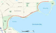
section of the city, it travels in a gently curving northeasterly direction 2.6 miles (4.2 km) through
1338:
1318:
1111:
1101:
861:
841:
694:
689:
567:
479:
1303:
1297:
1260:
1230:
1091:
1056:
1026:
856:
816:
761:
229:
225:
449:
1465:
1428:
1280:
1235:
926:
916:
881:
871:
821:
638:
174:
208:, M Street Beach and Pleasure Bay are beaches along Day Boulevard that are part of the park system.
1460:
1423:
1328:
1220:
1086:
1081:
1061:
891:
851:
663:
166:
127:
1433:
1373:
1148:
876:
836:
811:
771:
404:
Massachusetts reports: cases argued and determined in the
Supreme Judicial Court of Massachusetts
170:
1363:
1051:
380:
497:
1403:
1333:
1165:
1041:
921:
806:
562:
343:
238:
221:
1455:
1413:
1011:
577:
387:
220:, and was planned beginning in the late nineteenth century as the easternmost link of the
1449:
1398:
1313:
1250:
1106:
1076:
944:
906:
315:
182:
1519:
1470:
1418:
1408:
1393:
1388:
1368:
1343:
1245:
1225:
1096:
1006:
901:
233:
162:
80:
1353:
1066:
587:
131:
42:
337:
1358:
960:
633:
274:
359:
Address of Josiah Quincy, Mayor of Boston, to the City
Council, January 4, 1897
1348:
1210:
1205:
831:
237:
Boston political figure after he died in 1950. William Day was the father of
107:
94:
196:, site of a historic fort and state park. It is owned and maintained by the
406:. Vol. 209. Boston: Little, Brown, and Company. 1912. pp. 329–333
36:
478:. Washington, D.C.: United States House of Representatives. Archived from
1240:
1138:
886:
766:
17:
296:
992:
158:
72:
1122:
339:
A record of the streets, alleys, places, etc. in the city of Boston
1546:
Parks on the
National Register of Historic Places in Massachusetts
1536:
Roads on the
National Register of Historic Places in Massachusetts
964:
501:
312:"Castle Island, Pleasure Bay, M Street Beach and Carson Beach"
224:, the string of connected parks and waterways created by
198:
Massachusetts
Department of Conservation and Recreation
362:. Boston: Rockwell and Churchill. 1897. pp. 24–27
476:"Louise Day Hicks, Representative from Massachusetts"
241:, U.S. Representative for South Boston from 1971–73.
400:"John C. Phillips and others vs. the City of Boston"
169:
and
Kosciuszko Circle at the northern extent of the
1289:
1131:
999:
754:
733:
677:
611:
535:
137:
123:
86:
68:
60:
50:
188:In its eastern part, the road passes through the
177:along beaches around the west and north shore of
1491:denote streets and squares that no longer exist.
314:. Commonwealth of Massachusetts. Archived from
1541:National Register of Historic Places in Boston
976:
513:
232:across Dorchester via a parkway to be called
8:
306:
304:
29:
983:
969:
961:
529:Metropolitan Park System of Greater Boston
520:
506:
498:
202:Metropolitan Park System of Greater Boston
35:
28:
940:Department of Conservation and Recreation
190:South Boston Boat Clubs Historic District
55:Department of Conservation and Recreation
427:"Louise Day Hicks, icon of tumult, dies"
216:Day Boulevard was originally called the
261:
448:Reed, Christopher (October 29, 2003).
342:. Boston City Council. 1910. p.
45:with Day Boulevard highlighted in red
7:
297:http://www.mass.gov/mgis/dd-over.htm
246:National Register of Historic Places
25:
950:List of Massachusetts State Parks
425:Feeney, Mark (October 22, 2003).
192:and Marine Park before ending at
1266:Veterans of Foreign Wars Parkway
1121:
250:Old Harbor Reservation Parkways
244:Day Boulevard is listed on the
228:. Plans for the connection of
1:
1419:Nubian Square (Dudley Square)
450:"Obituary: Louise Day Hicks"
1562:
1211:Jersey Street (Yawkey Way)
157:, is a coastal parkway in
1526:Parkways in Massachusetts
1484:
1118:
935:
782:Charles River Reservation
108:42.3308833°N 71.0306611°W
64:2.6 mi (4.2 km)
34:
1505:Transportation in Boston
151:William J. Day Boulevard
30:William J. Day Boulevard
1500:Neighborhoods in Boston
991:Streets and squares in
113:42.3308833; -71.0306611
862:Nahant Beach Boulevard
777:Blue Hills Reservation
1057:Melnea Cass Boulevard
678:Woodland reservations
548:Boston Harbor Islands
226:Frederick Law Olmsted
1281:West Roxbury Parkway
1216:Massachusetts Avenue
927:Winthrop Shore Drive
734:Heritage state parks
536:Coastal reservations
1256:Turtle Pond Parkway
1221:Morrissey Boulevard
1132:North–south streets
1087:Soldiers Field Road
1017:Commonwealth Avenue
892:Soldiers Field Road
852:Morrissey Boulevard
669:Upper Charles River
664:Squantum Point Park
603:Weymouth Back River
318:on October 28, 2012
181:. It was named for
167:Morrissey Boulevard
128:Morrissey Boulevard
104: /
31:
1439:Post Office Square
1276:West Boundary Road
1149:Blue Hills Parkway
1072:New Chardon Street
1047:Gallivan Boulevard
877:Quincy Shore Drive
755:Parkways and roads
715:Southwest Corridor
612:River reservations
429:. The Boston Globe
386:2011-05-24 at the
1531:Streets in Boston
1513:
1512:
1364:Downtown Crossing
1309:Blackstone Square
1271:Washington Street
1181:Dorchester Avenue
1052:Huntington Avenue
1000:East–west streets
958:
957:
659:Pope John Paul II
558:Dorchester Shores
482:on March 11, 2016
148:
147:
16:(Redirected from
1553:
1444:Roxbury Crossing
1424:Packard's Corner
1404:Louisburg Square
1384:Haymarket Square
1334:Cleveland Circle
1186:Enneking Parkway
1166:Brookline Avenue
1125:
985:
978:
971:
962:
867:Nantasket Avenue
827:Hull Shore Drive
543:Belle Isle Marsh
522:
515:
508:
499:
492:
491:
489:
487:
472:
466:
465:
463:
461:
445:
439:
438:
436:
434:
422:
416:
415:
413:
411:
396:
390:
378:
372:
371:
369:
367:
354:
348:
347:
334:
328:
327:
325:
323:
308:
299:
293:
287:
286:
284:
282:
266:
239:Louise Day Hicks
222:Emerald Necklace
119:
118:
116:
115:
114:
109:
105:
102:
101:
100:
97:
77:Middlesex County
39:
32:
21:
1561:
1560:
1556:
1555:
1554:
1552:
1551:
1550:
1516:
1515:
1514:
1509:
1480:
1476:Winthrop Square
1461:Thompson Square
1456:Sullivan Square
1414:Maverick Square
1379:Franklin Square
1369:Egleston Square
1285:
1196:Franklin Street
1176:Columbus Avenue
1144:Atlantic Avenue
1127:
1126:
1116:
1022:Congress Street
1012:Boylston Street
995:
989:
959:
954:
931:
750:
729:
725:Wilson Mountain
710:Quincy Quarries
705:Middlesex Fells
673:
607:
578:Nantasket Beach
531:
526:
496:
495:
485:
483:
474:
473:
469:
459:
457:
447:
446:
442:
432:
430:
424:
423:
419:
409:
407:
398:
397:
393:
388:Wayback Machine
379:
375:
365:
363:
356:
355:
351:
336:
335:
331:
321:
319:
310:
309:
302:
294:
290:
280:
278:
270:"Day Boulevard"
268:
267:
263:
258:
248:as part of the
214:
200:as part of the
165:. Beginning at
144:in South Boston
112:
110:
106:
103:
98:
95:
93:
91:
90:
46:
23:
22:
15:
12:
11:
5:
1559:
1557:
1549:
1548:
1543:
1538:
1533:
1528:
1518:
1517:
1511:
1510:
1508:
1507:
1502:
1497:
1493:
1492:
1485:
1482:
1481:
1479:
1478:
1473:
1468:
1463:
1458:
1453:
1450:Scollay Square
1446:
1441:
1436:
1434:Peabody Square
1431:
1426:
1421:
1416:
1411:
1406:
1401:
1399:Kenmore Square
1396:
1394:Jackson Square
1391:
1386:
1381:
1376:
1371:
1366:
1361:
1356:
1351:
1346:
1341:
1336:
1331:
1326:
1324:Chester Square
1321:
1319:Central Square
1316:
1314:Brigham Circle
1311:
1306:
1301:
1293:
1291:
1287:
1286:
1284:
1283:
1278:
1273:
1268:
1263:
1258:
1253:
1251:Truman Parkway
1248:
1243:
1238:
1233:
1228:
1223:
1218:
1213:
1208:
1203:
1201:Hanover Street
1198:
1193:
1191:Federal Street
1188:
1183:
1178:
1173:
1171:Charles Street
1168:
1163:
1160:Brattle Street
1156:
1154:Bowdoin Street
1151:
1146:
1141:
1135:
1133:
1129:
1128:
1120:
1119:
1117:
1115:
1114:
1109:
1107:Tremont Street
1104:
1099:
1094:
1089:
1084:
1079:
1077:Newbury Street
1074:
1069:
1064:
1059:
1054:
1049:
1044:
1039:
1037:Dedham Parkway
1034:
1029:
1024:
1019:
1014:
1009:
1003:
1001:
997:
996:
990:
988:
987:
980:
973:
965:
956:
955:
953:
952:
947:
945:Greater Boston
942:
936:
933:
932:
930:
929:
924:
919:
914:
909:
904:
899:
894:
889:
884:
879:
874:
869:
864:
859:
854:
849:
847:Memorial Drive
844:
839:
834:
829:
824:
819:
814:
809:
804:
799:
794:
789:
784:
779:
774:
769:
764:
758:
756:
752:
751:
749:
748:
743:
737:
735:
731:
730:
728:
727:
722:
717:
712:
707:
702:
697:
692:
687:
681:
679:
675:
674:
672:
671:
666:
661:
656:
654:Neponset River
651:
646:
641:
636:
631:
626:
621:
615:
613:
609:
608:
606:
605:
600:
595:
590:
585:
580:
575:
570:
565:
560:
555:
550:
545:
539:
537:
533:
532:
527:
525:
524:
517:
510:
502:
494:
493:
467:
440:
417:
391:
373:
349:
329:
300:
288:
260:
259:
257:
254:
213:
210:
183:William J. Day
179:Dorchester Bay
146:
145:
139:
135:
134:
125:
121:
120:
88:
84:
83:
70:
66:
65:
62:
58:
57:
52:
48:
47:
40:
24:
14:
13:
10:
9:
6:
4:
3:
2:
1558:
1547:
1544:
1542:
1539:
1537:
1534:
1532:
1529:
1527:
1524:
1523:
1521:
1506:
1503:
1501:
1498:
1495:
1494:
1490:
1487:
1486:
1483:
1477:
1474:
1472:
1471:Uphams Corner
1469:
1467:
1464:
1462:
1459:
1457:
1454:
1452:
1451:
1447:
1445:
1442:
1440:
1437:
1435:
1432:
1430:
1427:
1425:
1422:
1420:
1417:
1415:
1412:
1410:
1409:Mass and Cass
1407:
1405:
1402:
1400:
1397:
1395:
1392:
1390:
1387:
1385:
1382:
1380:
1377:
1375:
1374:Fields Corner
1372:
1370:
1367:
1365:
1362:
1360:
1357:
1355:
1352:
1350:
1347:
1345:
1344:Copley Square
1342:
1340:
1339:Codman Square
1337:
1335:
1332:
1330:
1327:
1325:
1322:
1320:
1317:
1315:
1312:
1310:
1307:
1305:
1304:Andrew Square
1302:
1300:
1299:
1295:
1294:
1292:
1290:Intersections
1288:
1282:
1279:
1277:
1274:
1272:
1269:
1267:
1264:
1262:
1259:
1257:
1254:
1252:
1249:
1247:
1246:School Street
1244:
1242:
1239:
1237:
1234:
1232:
1229:
1227:
1226:Morton Street
1224:
1222:
1219:
1217:
1214:
1212:
1209:
1207:
1204:
1202:
1199:
1197:
1194:
1192:
1189:
1187:
1184:
1182:
1179:
1177:
1174:
1172:
1169:
1167:
1164:
1162:
1161:
1157:
1155:
1152:
1150:
1147:
1145:
1142:
1140:
1137:
1136:
1134:
1130:
1124:
1113:
1112:Winter Street
1110:
1108:
1105:
1103:
1102:Summer Street
1100:
1098:
1097:Storrow Drive
1095:
1093:
1090:
1088:
1085:
1083:
1080:
1078:
1075:
1073:
1070:
1068:
1065:
1063:
1060:
1058:
1055:
1053:
1050:
1048:
1045:
1043:
1040:
1038:
1035:
1033:
1032:Day Boulevard
1030:
1028:
1025:
1023:
1020:
1018:
1015:
1013:
1010:
1008:
1007:Beacon Street
1005:
1004:
1002:
998:
994:
986:
981:
979:
974:
972:
967:
966:
963:
951:
948:
946:
943:
941:
938:
937:
934:
928:
925:
923:
920:
918:
915:
913:
910:
908:
905:
903:
902:Storrow Drive
900:
898:
895:
893:
890:
888:
885:
883:
880:
878:
875:
873:
870:
868:
865:
863:
860:
858:
857:Mystic Valley
855:
853:
850:
848:
845:
843:
840:
838:
835:
833:
830:
828:
825:
823:
820:
818:
817:Furnace Brook
815:
813:
810:
808:
805:
803:
802:Fellsway West
800:
798:
797:Fellsway East
795:
793:
790:
788:
787:Day Boulevard
785:
783:
780:
778:
775:
773:
770:
768:
765:
763:
762:Alewife Brook
760:
759:
757:
753:
747:
744:
742:
739:
738:
736:
732:
726:
723:
721:
718:
716:
713:
711:
708:
706:
703:
701:
698:
696:
693:
691:
688:
686:
683:
682:
680:
676:
670:
667:
665:
662:
660:
657:
655:
652:
650:
647:
645:
644:Hemlock Gorge
642:
640:
637:
635:
632:
630:
629:Chestnut Hill
627:
625:
624:Charles River
622:
620:
619:Alewife Brook
617:
616:
614:
610:
604:
601:
599:
598:Webb Memorial
596:
594:
591:
589:
586:
584:
581:
579:
576:
574:
571:
569:
566:
564:
561:
559:
556:
554:
553:Castle Island
551:
549:
546:
544:
541:
540:
538:
534:
530:
523:
518:
516:
511:
509:
504:
503:
500:
481:
477:
471:
468:
455:
451:
444:
441:
428:
421:
418:
405:
401:
395:
392:
389:
385:
382:
377:
374:
361:
360:
353:
350:
345:
341:
340:
333:
330:
317:
313:
307:
305:
301:
298:
292:
289:
277:
276:
271:
265:
262:
255:
253:
251:
247:
242:
240:
235:
234:Dorchesterway
231:
230:Franklin Park
227:
223:
219:
211:
209:
207:
203:
199:
195:
194:Castle Island
191:
186:
184:
180:
176:
172:
168:
164:
163:Massachusetts
160:
156:
155:Day Boulevard
152:
143:
142:Castle Island
140:
138:East end
136:
133:
129:
126:
124:West end
122:
117:
99:71°01′50.38″W
96:42°19′51.18″N
89:
85:
82:
81:Massachusetts
78:
74:
71:
67:
63:
59:
56:
53:
51:Maintained by
49:
44:
38:
33:
27:
19:
1488:
1466:Union Square
1448:
1354:Dewey Square
1298:Adams Square
1296:
1261:Union Street
1231:North Street
1158:
1092:State Street
1067:Neptune Road
1031:
1027:Court Street
917:West Roxbury
882:Revere Beach
786:
700:Hammond Pond
685:Beaver Brook
649:Mystic River
593:Rumney Marsh
588:Revere Beach
583:Quincy Shore
573:Nahant Beach
486:December 16,
484:. Retrieved
480:the original
470:
460:December 16,
458:. Retrieved
454:The Guardian
453:
443:
433:December 16,
431:. Retrieved
420:
410:December 16,
408:. Retrieved
403:
394:
376:
366:December 16,
364:. Retrieved
358:
352:
338:
332:
322:December 16,
320:. Retrieved
316:the original
291:
279:. Retrieved
273:
264:
243:
217:
215:
206:Carson Beach
187:
175:South Boston
154:
150:
149:
132:South Boston
43:South Boston
26:
1429:Park Square
1389:Hyde Square
1359:Dock Square
1329:City Square
1082:Park Street
1062:Milk Street
897:Stony Brook
822:Hamond Pond
720:Stony Brook
563:Fort Revere
275:Google Maps
111: /
87:Coordinates
1520:Categories
1349:Day Square
1236:Park Drive
1206:Jamaicaway
872:Park Drive
837:Lynn Fells
832:Jamaicaway
812:Fresh Pond
772:Blue Hills
695:Breakheart
690:Blue Hills
568:Lynn Shore
256:References
171:Dorchester
218:Strandway
18:Strandway
1496:See also
1241:Riverway
1139:Arborway
922:Winthrop
887:Riverway
792:Fellsway
767:Arborway
639:Elm Bank
456:. London
384:Archived
69:Location
1489:Italics
842:Lynnway
746:Roxbury
281:May 25,
272:(Map).
212:History
41:Map of
1042:Fenway
993:Boston
907:Truman
807:Fenway
634:Cutler
159:Boston
73:Boston
61:Length
153:, or
741:Lynn
488:2009
462:2009
435:2009
412:2009
368:2009
324:2009
283:2019
912:VFW
344:443
130:in
1522::
452:.
402:.
303:^
252:.
204:.
185:.
161:,
79:,
75:,
984:e
977:t
970:v
521:e
514:t
507:v
490:.
464:.
437:.
414:.
370:.
346:.
326:.
285:.
20:)
Text is available under the Creative Commons Attribution-ShareAlike License. Additional terms may apply.