2099:
916:
2062:
2053:
Alonso de
Andrada, chaplain of the expedition of Captain Juan Rodríguez Suárez. The first uninterrupted religious services, began in April 1561 in the Fort of Tapias, after the foundation of the city of San Cristobal. Thus, the first and oldest parish in the State of Táchira is the current parish of El Sagrario/San Cristóbal Cathedral, whose oldest sacramental books have been preserved since 1601. The Diocese of San Cristóbal de Venezuela/Dioecesis Sancti Christophori in Venetiola (erected by the Apostolic Constitution Ad munus of 1922), with its episcopal see in the city of San Cristóbal, belongs to the ecclesiastical province of the Archbishopric of Mérida.
877:
the Torbes River separates the main range of the Mérida Range from the Tamá Range. During the
Tertiary period, the uplifts of failed blocks formed deep valleys like those of the Uribante and Torbes rivers, with very steep slopes. In addition, there are relatively open basins with gently sloping terrain (San Cristóbal-Táriba-Rubio). The northern slopes come into contact with the lowlands located south of Lake Maracaibo, with large marshy areas, while the southeastern sector, from the eastern slope of the Uribante branch, is a transition zone between the piedmont (the lowlands of the mountainous formation) and the western high plains.
2319:
the first radio station in the region and one of the pioneers of radio in
Venezuela; later, in 1935, it began its formal transmissions, La Voz del Táchira (called Radio Táchira since 1971). Among the most representative capital stations (in AM) are Ecos del Torbes (founded in 1947), which can currently be heard from anywhere in the world and has its own news website; there are also the stations Radio Táchira, Radio Noticias 1060 (formerly Ondas de América and Radio San Cristóbal (in operation since 1954) that belong to the same González Lovera radio circuit and Radio San Sebastián.
2045:
198:
682:
into districts. The executive power of the Táchira section was exercised by
General Rosendo Medina, who was replaced by General Francisco Alvarado, who was short-lived because President Guzmán Blanco imposed his delegate in the Táchira, General Marcos Rodríguez. The arrival of General Ignacio Andrade to the presidency of the Republic favored the State, since the first National Magistrate to weaken the political-administrative structures of former President Joaquín Crespo, influenced the Congress to achieve a new territorial division.
1084:
2273:
1930:
1159:
1048:
1059:
2603:
2123:
690:
604:
2323:
1189:
780:
678:
organs of the
Provincial Government were established, with a general population of 42,731 inhabitants. The decree of the congress with date 11 of March was sanctioned by the National Executive day 14. General Jose Tadeo Monagas governed in the Country, who named to exercise the position of the Province, to the citizen Pascual Casanova, assuming the position of Governor of the State Táchira, this civil employee was named May 9 being sworn in its position the 1 of July 1856.
171:
1384:
1354:
1174:
2241:
233:
1037:
1004:
2252:., which has won 8 titles in the First Division of Venezuela and also the Venezuelan club that has participated more times (22) in the Libertadores Cup of America; there are also Ureña Sport Club and Real Frontera Sport Club, the latter two members of the Second Division of Venezuela. Among other disciplines the Vuelta al Táchira in bicycle stands out, of great importance at national level, and that marks the beginning of the UCI America Tour.
1876:
1537:
188:
1249:
2202:
895:
1513:
2076:
533:
2087:
costumbrist towns (Peribeca, San Pedro del Río, El Cobre, Pregonero), the architecture of San Cristóbal, La Grita, the numerous restaurants of typical Andean food, the sporting events held in the city of San Cristóbal (mainly the meetings of the
Deportivo Táchira Fútbol Club, of the Venezuelan First Division League), the fairs and patron saint's celebrations, mainly the San Sebastián International Fair (FISS), among many others.
1444:
1414:
1369:
1399:
2347:
1219:
974:
788:
1339:
1069:
1509:
metropolitan population that exceeds 400,000 inhabitants. Its topography extends under a succession of river terraces and has an average temperature of 23 °C. It is at an altitude of 825 meters above sea level, which gives it a pleasant climate. San Cristóbal was founded on March 31, 1561, by the captain and advanced Juan
Maldonado y Ordóñez, which makes it one of the oldest cities in Venezuela.
1294:
1324:
42:
1489:
1474:
1429:
1309:
1279:
1234:
1204:
1129:
1099:
743:
1144:
1114:
869:
666:
1459:
1264:
950:
the
Tachira Depression, from the Pliocene); intramountain areas surrounded by higher ground, known as valleys (from the Pleistocene era). These are where the largest towns and cities are located); and the plains or lowlands of the north - lakes or the lake - and the south of the state - river plains - (areas of piedmont formed between the Miocene and Pliocene).
847:
The orography is uneven and influenced by the course of numerous rivers and streams that form valleys at the base of the mountains, as an example the capital city is settled on the valley of the river Torbes, this area represents most of the surface of the state. The main cities located in this area are San Cristóbal, Táriba, Michelena, Rubio and La Grita.
924:
698:
better communication routes and the implementation of control measures on the agricultural trade of the state that was almost totally exported. Táchira State plays an important role in the early parts of
Venezuelan history. This state produced more presidents than any other state during the 20th century:
2255:
Some sports facilities include the "Juan
Maldonado" Sports Complex, the "La Marina" Park, the "Metropolitano" Park, the "Paramillo" Sports Complex, the "Pueblo Nuevo" Sports Complex which has facilities such as the J. J. Mora Velodrome, the San Cristóbal Metropolitan Stadium, the Monumental Bullring,
2086:
The state of Táchira offers different tourist attractions among which the walks on the mountain routes and the moors El Zumbador, Los Rosales, La Negra, el Tamá stand out; the cattle areas of the road to the plain and the South of the Lake (from Maracaibo), the Pan-American route, the traditional and
1520:
Nowadays, the city of San Cristóbal is recognized by its wide academic and cultural activity. Its universities are recognized: Universidad de los Andes (Táchira nucleus), Universidad Nacional Experimental del Táchira (UNET) and Universidad Católica del Táchira (UCAT), among others, as well as for its
949:
The tectonic forces generated by this collision created: the shapes of the highest mountains and peaks (El Pico El Púlpito, 3,912 m, in the northeastern end, and Cerro El Cobre, 3,612 m, in the southwestern end. Both are known as 'The Guardian Pillars of the Tachira'); a tectonic depression (known as
936:
Far North, confluence of the Rio Grande with the Rio Escalante (Pan-American); Far South, confluence of the Rio Burgua with the Los Pensamientos stream (Fernández Feo); Far East, confluence of the Rio Doradas (Cauce Viejo) with the Rio Caparo (Libertador); Far West, eastern bank of the Rio Táchira in
864:
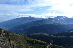
Its territory has an area of 11,100 km2, where the Andean physiographic character predominates, with heights above 2,000 m. The mountainous relief is the southern continuation of the Merida mountain range, which penetrates from the north in a southwesterly direction, exceeding 4,000 m in the La Negra
850:
Pan-American circuit: this zone is located mainly in the north of the state, it shares the climatic characteristics of the southern region of the lake (of Maracaibo), with a tropical jungle climate, high rainfall and high temperatures. This region is one of the main centers of livestock production in
729:
At the end of the 19th century, the people of Táchira State were tired of being left out of the main country's decisions. Consequently, a group of men decided to start a revolution called the "Revolución Restauradora" (The Restorative Revolution). The idea was to take power and enhance the importance
697:
In 1899, Cipriano Castro began the invasion of Venezuela from the State of Táchira with an armed group that confronted the regime of Ignacio Andrade. The successive presidents of Venezuela of Tachira origin initiate a process of greater integration of the state to the country with the construction of
2306:
Televisora Regional del Táchira (TRT), the oldest. TVCT Canal 21, a television plant with an open signal. Buena TV, the most recently created channel. As well as other community channels, such as Vida TV in Rubio and Montaña TV in Cordero. Similarly in Ureña there is a television station that covers
2106:
The Ateneo del Táchira is the oldest in Venezuela, apart from being the first cultural center erected in the mentioned entity. Its foundation was carried out on April 19, 1907, although the construction that today looks was initiated in 1935, it is located in the street 9 with street 6 in the center
885:
The climate presents great variations, mainly due to the modifications by the height, in populations of the route to the plain, in the piedmont (El Piñal, San Joaquin de Navay among others), can reach temperatures of 30 °C like in the Pan-American route (La Fría, Coloncito). In the capital, San
2052:
The state is predominantly Christian with the most widespread denomination being the Catholic faith. The first mass celebrated in the territory of the present Táchira State, was on July 25, 1558 in the Santiago Valley, on the solemnity of Santiago Apostle, and was carried out by the Dominican Friar
999:
The State Legislature is the responsibility of the unicameral Legislative Council of the State of Táchira, elected by the people by direct and secret vote every (4) four years, and they may be re-elected for new consecutive periods, under a system of proportional representation of the population of
969:
The State is autonomous and equal in political terms to the rest of Venezuela, its administration and public powers are organized through the Constitution of the State of Táchira, approved by the Legislative Council and published in the extraordinary official gazette of the State of Táchira, number
945:
The Tachira Andes were formed during the Eocene period (between 56 million and 40 million years ago approximately), when the Nazca tectonic plate and the Caribbean plate began to slowly slide under the South American plate, raising older formations and bending the sedimentary and igneous rocks that
876:
In the extreme southwest, the Táchira depression was formed, which includes the tectonic trench through which the river of the same name runs and the entire relatively low area located between this trench and the valleys of the Lobaterita, the Torbes Medio and the Quinimarí Medio. The depression of
846:
Mountain circuit; in this region are the main urban settlements in the state, the climate is temperate at high altitude8 in most of the region and high moorland at elevations above 3000 meters above sea level, with slight variations throughout the year, has a clear rainy season from May to October.
661:
Despite the progressive population growth of the region, its importance as Venezuela's main coffee producer for over two hundred years and the arrival of important European trading houses in the 19th century, the state remained relatively isolated from the rest of the country, with greater cultural
2318:
The radio is the most traditional means of communication in the state, the first receptions were made through the radio service of Venezuela in 1926. In 1933, Radio Táchira, with a small transmitter with a range of less than one kilometer, began to operate informally in the state capital.10 It was
990:
The State chooses its own Legislative Council as well as a Governor who is the Chief Executive of the State and is elected every 4 years; as of 1989, before that year he was elected by the President in office, his last Governor appointed by President Carlos Andrés Peréz, was Governor Jorge Enrique
775:
Táchira State is located in the Andes. Its highest point is La Montaña el Pulpito, which about 3995 meters above the sea level. Táchira's population is mainly located in San Cristóbal, the most important and prosperous city of this state. Tariba, Rubio, Colon, and La Grita are also other important
2330:
In the interior of the state, radio has also reached an important development. Thus, as early as 1954 in the city of Rubio, the station Ecos de Junín began to broadcast, which was later taken to San Cristóbal. In 1965, Radio Frontera emerged in San Antonio del Táchira and in 1970 Radio Sucesos de
1016:
The state of Táchira, in accordance with Article 164 of the Venezuelan Constitution and Article 45 of the Constitution of the state of Táchira of 2014, has its own police force, called Politáchira, created in July 1960. Its functions are regulated by state and national laws, namely the Law of the
986:
It is composed of the Governor of Táchira and a group of state secretaries. The Governor is elected by the people by direct and secret vote for a period of four years and has the possibility of re-election for equal periods and a recall referendum in the middle of his term, being in charge of the
854:
Llanos region: a small part of the Venezuelan plains are briefly located southeast of the state of Táchira, on the border with the states of Apure and Barinas, the climate is tropical savannah, with less humidity than in the Pan-American zone, it is also a region of high livestock production. Its
681:
In 1881, during the second presidency of General Antonio Guzmán Blanco, the National Constitution was reformed, establishing that the Republic is composed of nine great States; one of them was the great State of the Andes, with the sections Trujillo, Mérida and Táchira, each section being divided
637:
With the foundation of San Cristóbal in 1561 by Captain Juan Maldonado Ordoñez y Villaquirán and La Grita in 1576 by Francisco de Cáceres, the agricultural exploitation of the area began, giving rise to the creation of new settlements. Since its foundation in 1576, La Grita was the capital of the
616:
Possible origins have been identified for the word Táchira, so one hypothesis states that the word is an indigenous word - based on Chibcha dialects - composed of three particles: ta, "farm" (as a root), chi, "ours, which belongs to us" and the suffix rá, "element that expresses place, moment or
1941:
Banking: Apart from the large national banks, the main bank in the region is represented by Banco Sofitasa, a solid financial institution that serves as an economic engine for the financing of many projects in the region. Táchira is also a business location for many other banking offices with a
911:
The hydrography is varied, there are several rivers of considerable course; the Torbes river, the Caparo river, the Uribante and the Doradas rivers among others, there are also some lakes and reservoirs, like the Uribante reservoir, the Caparo reservoir, the Garcia lagoon, the Rosal lagoon, the
677:
On March 11, 1856, by decree of the Sovereign Congress of the Republic, the Province of Táchira was created, formed with the cantons of San Cristóbal, San Antonio, Lobatera and La Grita. It was decided that the capital of the Province would be San Cristóbal and there the headquarters of all the
2268:
El Táchira has important highways and a network of roads that cover much of its territory and communicate with the rest of the country: the Trasandina Highway, the Pan-American Highway or Trunk 1, the road to the plain or Trunk 5 and the San Cristóbal - La Fría Highway that is currently under
2090:
It is also the Táchira center for river sports activities, such as sport fishing (developed in the numerous river courses of the State, mainly in the Uribante, Caparo and Doradas rivers), some activities such as canoeing and other specialties are developed in the artificial lake formed by the
733:
Until the start of the 20th century, it was highly difficult traveling between Táchira State and others and even within the state itself. This condition led to cultural differences between the people of Táchira and those from the rest of Venezuela. The former were more influenced by Colombian
1508:
The city of San Cristóbal is the capital of the state. It is an important economic pole for the country since it is located in the Colombian-Venezuelan border axis and, therefore, it is a commercial city where small and medium entrepreneurs develop important commercial transactions. It has a
540:
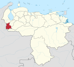
Táchira State covers a total surface area of 11,100 square kilometres (4,300 sq mi) and as of the 2011 census, had a population of 1,168,908. At the end of the 19th century, Táchira State was where oil was discovered in Venezuela. Currently, its main economic revenues come from the
2094:
The sites of greatest interest, both tourist and historical, are represented by some buildings of architectural value, which are closely linked with the Tachirenses due to the activities that are developed there such as public buildings, religious centers, entertainment and sports centers.
2280:
The state has 4 airports, of which 3 are classified as international: Juan Vicente Gomez International Airport (closed), Santo Domingo International Airport and the International Airport "Francisco Garcia de Hevia" in La Fria, also has the Paramillo Airport a small capacity airport.
1529:
The San Cristóbal metropolitan area, made up of the municipalities of Andrés Bello, Cárdenas, Córdoba, Guásimos, Libertad, Independencia, Tórbes and San Cristóbal, will have around 263,7659 inhabitants in 2011, which represents the largest population concentration in the state.
2110:
During January the Capital city of San Cristóbal celebrates its fiesta, which is recognized nationally for its industrial, commercial and agricultural exhibitions. During this time there are bull-fights, events, parties, and a number of artists come to have their shows.
2294:
The state's newspapers are based in San Cristóbal, these are the Diario Católico and the Diario La Nación. In addition to those mentioned, there is the Diario de los Andes, originally from Trujillo state, which has its own editorial and circulation for Táchira.
886:
Cristóbal, the average daytime temperature is 24 °C and the nighttime temperature is 18 °C. However, in cities like Pregonero, El Cobre, La Grita and others located at higher altitudes, the temperature is considerably lower (up to 10 °C).
2334:
FM began to develop in the 1990s with the launch of station 102.1 Stereo, known today as La Mega 102.1FM (currently part of the Mega Circuit). Since then, FM has been widely developed both in the capital and in the interior of the state.
641:
In 1781 Juan Jose Garcia de Hevia led the Insurrection of the Communards of Los Andes, an anti-colonial revolutionary movement that sought to liberate Venezuela from the colonialism of the Spanish Empire, under the search for tax relief.
673:
In a country that now depends on an economy based on oil income, the Táchira was privileged to have the first oil wells in Venezuela. At the end of the 19th century the national oil industry was born in the place now called La Petrolia.
991:
Romero, since 1989 he is chosen under direct elections, the current Governor Laidy Gómez is elected for the period (2017 - 2021) with the support of her party AD and other political organizations related to the Venezuelan opposition.
2269:
construction. It also has three international bridges that connect it with neighboring Colombia: International Bridge Simon Bolivar, International Bridge Francisco de Paula Santander and the International Bridge Las Tienditas.
638:
Province of La Grita, so the importance of this city was primitive in the region until the arrival of European trading companies to the state, which settled mainly in the more accessible and better communicated San Cristóbal.
620:
On the other hand, it is believed that Táchira comes from a Chibcha word that comes from the term "tachure", which identifies a purple dye plant that has medicinal uses, known as tun-túa or sibidigua (Jatropa gossypifolia).
2098:
1017:
Autonomous Institute of Police of the State of Táchira, the former; and the Organic Law of the Police Service, the latter. It reports to the Secretariat of State Security and is primarily responsible for regional security.
1859:
The majority of the state's population is white, European contribution is notably higher than that of Indigenous and African Venezuelans. It is one of the Venezuelan states with the highest proportion of whites, mostly of
902:
The mountain vegetation includes specimens such as the Lasso pine and eucalyptus. The apamates and the creole cedar are abundant. Mangos, guamas, pomarrosas, guavas and other fruit trees are common in most of the state.
1919:
Manufacturing: textiles, footwear, clothing, leather factories; industries mainly located in the border area; currently they have been greatly reduced by the exchange rate differential and the closure of the
685:
In 1895, the Gran Ferrocarril del Táchira was inaugurated, its construction began in 1893 with an extension of 105 kilometers between La Fría and Encontrados to mobilize the great crops of Tachira coffee.
2567:
1872:
The Táchira has a very active economy because it is a border state where there is a great flow of capital, goods and services that exist between Venezuela and Colombia passing through this region.
2248:
The state of Táchira, together with Mérida and Trujillo, has been characterized as a region where the most popular sport is football. Currently the main football clubs based in the state are
915:
946:
form today's mountains (several of the highest peaks and moors in the State of Tachira are from the Phanerozoic eon, from the Precambrian period, about 539 million years ago).
2974:
2560:
937:
front of the Cerrito, village Sabana Larga (Pedro María Ureña). Distance between the extreme points of the State: north-south, 147.88 km; east-west: 129.03 km.
634:
Populated mainly by groups of Timote, Cuica and Chibcha origin and as the Machirí, Umuquena and Táriba, the territory was extensively colonized in the sixteenth century.
2463:
Atlas del estado Táchira: cartografía, geología, clima, hidrografía, geomorfología--suelos, vegetatión, vocaciones, socio cultural--población, economía, mapas especiales
617:
position (...)" with respect to the future. Thus, it would mean approximately a term like: "The land that will be our inheritance" or "The land of our inheritance".
2553:
2061:
220:
1447:
175:
754:
In 1863 it acquired the category of State, a fact that was ratified in 1864 when it became part, as an independent state, of the United States of Venezuela.
842:
Crossed by the extension of the Andes mountain range from south to northwest, it divides the state into three different regions with a particular climate:
1771:
2893:
325:
2385:
197:
760:
In 1881, when the country was divided into 9 states, it became part, together with Guzmán (Mérida) and Trujillo, of the Great State of Los Andes.
221:
1020:
Like the other 23 federal entities of Venezuela, the State maintains control over own police force, which is supported and complemented by the
2576:
2257:
851:
Venezuela. It is on the border of the states of Zulia and Mérida. The main populations of this region are: La Fría, La Tendida and Coloncito.
444:
2143:
Sports facilities built for the 2005 Andes National Games, and 2007 Copa America: (Gymnastics Pavilion, indoor soccer stadiums, handball...)
317:
1904:
Industrial zone of Ureña, the largest and most diverse in the state (bodywork, plastics, textiles, furniture, construction, among others).
1357:
1252:
170:
1117:
2813:
763:
In 1899, the State of Los Andes was dissolved and Táchira recovered its status as an independent State, which it maintains to this day.
2849:
2739:
125:
1267:
1102:
766:
It has remained a state since 1899, although like other states in Venezuela it did not achieve full autonomy until the early 1990s.
249:
2910:
471:
400:
369:
1764:
1177:
2923:
1803:
646:
63:
2808:
1462:
2602:
751:
In 1856 it was part of the Province of Táchira within the territories of La Grita, Lobatera, San Antonio and San Cristóbal.
106:
1402:
800:
597:
424:
346:
341:
2513:
1387:
1222:
723:
78:
2969:
2584:
2044:
1072:
1406:
1087:
526:
302:
2619:
1297:
232:
59:
28:
1282:
1132:
85:
2915:
1147:
1121:
715:
707:
2428:
1417:
1372:
1192:
954:
Highest point: El Púlpito Peak (3,912 m, Páramo de Batallón Mountain Range, Jáuregui and Uribante Municipalities).
52:
2864:
2859:
2854:
2844:
2839:
2249:
1025:
711:
1162:
1083:
719:
2874:
2869:
2834:
2802:
2762:
2272:
1342:
546:
1929:
1158:
1151:
92:
2767:
1765:"XIV CENSO NACIONAL DE POBLACIÓN Y VIVIENDA - Resultados por Entidad Federal y Municipio del Estado Táchira"
1327:
459:
212:
187:
1492:
1432:
1312:
1237:
1207:
2772:
2747:
1166:
1047:
1477:
1181:
74:
2122:
2065:
1816:
1451:
1091:
1058:
689:
603:
1536:
1346:
1040:
703:
2461:
2445:
2411:
2322:
2310:
Currently the Colombian channels are transmitted as Channel 1, Citytv and Channel TRO for this state.
1887:
Fishing: blanco pobre, cachama, cajaro, coporo, palometa, torumo, tumare (in rivers), striped catfish.
1188:
1076:
2826:
2797:
2792:
2752:
1890:
Agricultural products: garlic, cambur, sugar cane, coffee, caraota, onion, potato, banana and tomato.
1569:
1548:
1376:
1361:
1256:
964:
779:
2964:
2884:
2611:
2360:
2035:
International Center for Continuing Education - Caribbean International University Curaçao - CIDEC-
1286:
1226:
1211:
1106:
1051:
518:
161:
1968:
Universidad Pedagógica Experimental Libertador, Instituto Pedagógico Rural "Gervasio Rubio" - UPEL
2704:
2134:
Covered markets: (La Guayana, Metropolitano, Los Pequeños Comerciantes, La Ermita, Santa Teresa).
2644:
2488:
1391:
1383:
1353:
2240:
2787:
2782:
2684:
2365:
2032:
Juan Pablo Pérez Alfonzo University Institute of Technology, San Cristóbal Extension - IUTEPAL
1436:
1421:
1316:
1301:
1173:
1036:
1021:
808:
573:
1533:
According to the data projected by the INE for the year 2013 the main population centers are
669:
German attic style heritage house built between 1884 and 1888 in San Cristóbal, Táchira State
2719:
1875:
1271:
577:
569:
513:
501:
150:
2201:
894:
2689:
2654:
2639:
2075:
2017:
Antonio José de Sucre University Institute of Technology, San Cristóbal Extension - IUTAJS
1861:
1829:
1512:
1248:
812:
699:
585:
532:
99:
1974:
Universidad Nacional Experimental Politécnica de la Fuerza Armada, Núcleo Táchira - UNEFA
2545:
2777:
2674:
1443:
1413:
1368:
730:
of the Andean Region in the country. It was led by Cipriano Castro and was successful.
330:
2346:
1896:
Forest resources: bucare, guamo, wax, laurel, butter, laso pine, quindu, among others.
1398:
1003:
973:
787:
2958:
2709:
2699:
2659:
2624:
816:
804:
650:
589:
437:
1218:
2757:
2679:
2352:
1481:
1338:
1068:
542:
2514:"Resultado Básico del XIV Censo Nacional de Población y Vivienda 2011 (Mayo 2014)"
1907:
Food industry: dairy products, confectionery, preserves, coffee, typical bakeries.
2011:
Santiago Mariño Polytechnic University Institute, San Cristóbal Extension - IUPSM
219:
2476:
1473:
1293:
581:
41:
1323:
742:
545:
activities play an important role in Táchira's economy. There is also a strong
2669:
2342:
1488:
1428:
1308:
1278:
1233:
1203:
1196:
1128:
1098:
868:
665:
420:
264:
251:
2940:
1786:
According to the 2011 Census, the racial composition of the population was:
1496:
1466:
1331:
1143:
1113:
522:
415:
284:
238:
2664:
2029:
Jesús Enrique Lossada University Institute, San Cristóbal Extension - IUJEL
1136:
1458:
1263:
2649:
2069:
1241:
796:
593:
432:
2724:
2694:
2592:
2080:
1601:
734:
culture, a more accessible region through Norte de Santander province.
17:
1913:
Handicrafts: hammocks, textiles, pottery, saddlery, woodwork, tannery.
2944:
2634:
2014:
Monsignor de Talavera University College, San Cristóbal Campus - CUMT
562:
550:
2091:
Uribante-Caparo dam, of the hydroelectric complex of the same name.
923:
2005:
Cecilio Acosta Catholic University, San Cristobal Extension - UNICA
653:
invaded the country through the Táchira in his Admirable Campaign.
2729:
2629:
2321:
2271:
2239:
2200:
2121:
2097:
2074:
2060:
2043:
1928:
1874:
1535:
1511:
1057:
1046:
1035:
972:
922:
914:
893:
867:
778:
741:
664:
602:
554:
531:
1980:
Simón Rodríguez National Experimental University, La Grita Center
1000:
the State and its municipalities. The State has 13 legislators.
558:
2549:
2537:
2140:
Hospital Central de San Cristóbal Dr. José María Vargas (HCSC)
1953:
The State of Táchira is the center of important universities.
35:
1596:
482:
217:
1977:
National Open University, Centro Local San Cristóbal - UNA
1971:
University Institute of Agro-Industrial Technology - IUTAI
1989:
Manuela Saenz Polytechnic University of the Territory UPT
965:
Cabinet of Venezuela § Federal Council of Government
919:
General Juan Pablo Peñaloza National Park, Táchira, State
872:
Mountain formations, El Tamá National Park, Táchira State
2416:(in Spanish). Biblioteca de Autores y Temas Tachirenses.
2002:
Bicentennial University of Aragua, San Táchira Agreement
855:
main populations are: La Pedrera, El Piñal and Abejales.
757:
Between 1867 and 1868 it was part of the State of Zulia.
2494:. International Stratigraphic Commission. February 2022
1916:
Mining industries: extraction of coal, asphalt, gypsum.
783:
Forest in the Borotá Mountains, Municipality Lobatera
1986:
Bolivarian University of Venezuela UBV Núcleo Táchira
2386:"Sub-national HDI - Area Database - Global Data Lab"
2303:
There are regional open-signal television channels:
2023:
University Institute of Industrial Technology - IUTI
536:
Typical rural house in the Prairies of Táchira State
2903:
2883:
2825:
2738:
2610:
2583:
2466:(in Spanish). Gobernación del Estado Táchira. 1986.
541:production of coffee and pineapple. The cattle and
477:
458:
443:
431:
414:
406:
396:
388:
383:
375:
365:
357:
352:
339:
323:
313:
308:
298:
290:
280:
143:
66:. Unsourced material may be challenged and removed.
2231:Cavernas de la Loma del Viento-Casa de John Rivera
1962:National Experimental University of Táchira - UNET
2307:the border, on both sides Intercanal Channel 10.
1540:Nuestra Señora de los Ángeles Church, in La Grita
746:Táchira as part of the Province of Mérida in 1840
662:influence received from Colombia for many years.
2256:the Armino Gutiérrez Castro Gymnasium and the
1992:National Experimental Security University UNES
1965:University of Los Andes, Táchira Nucleus - ULA
1923:Energy: Uribante-Caparo hydroelectric complex.
2561:
2119:Some important buildings in the capital are:
1983:Degree in Nursing, Romulo Gallegos University
8:
1587:
1557:San Antonio del Táchira: 69 661 inhabitants.
2198:Some natural heritages of the Táchira are:
2975:States and territories established in 1899
2568:
2554:
2546:
2186:National School of Dance (ENDANZA Táchira)
2159:The Ateneo del Táchira or Old Reading Room
1586:
549:sector which focuses on the processing of
140:
2427:estadística, Venezuela Dirección (1877).
2177:Plaza Monumental de Toros de Pueblo Nuevo
2102:Grande Lagoon, Páramo Batallón y La Negra
2026:Gran Colombia University Institute - IUGC
176:General Juan Pablo Peñaloza National Park
126:Learn how and when to remove this message
1788:
1002:
786:
688:
2430:Apuntes estadísticos del estado Táchira
2377:
2228:Thermal waters in Aguas Calientes Ureña
2048:San José Catholic Church, San Cristóbal
977:Bolivar Square, Libertador Municipality
476:
442:
430:
413:
382:
351:
307:
297:
289:
279:
244:
229:
209:
181:
167:
2809:Francisco de Miranda Insular Territory
361:11,100 km (4,300 sq mi)
2577:Administrative divisions of Venezuela
2020:Border University Institute - IUFRONT
2008:Catholic University of Táchira - UCAT
1560:San Juan de Colón: 69 387 inhabitants
592:and Barinas States to the south, and
512:
457:
405:
395:
387:
374:
364:
356:
338:
322:
312:
7:
2331:Táriba and Radio el Sol de La Fría.
1893:Livestock production: mainly cattle.
64:adding citations to reliable sources
2444:State), Tachira (Venezuela (1914).
2244:Pueblo Nuevo Stadium, Táchira State
2137:"Genaro Mendez" Passenger Terminal"
1545:San Cristóbal: 263 765 inhabitants.
2222:Juan Pablo Peñaloza National Park.
2210:Abra de Rio Frio natural monument.
1521:San Sebastián International Fair.
1032:Municipalities and municipal seats
795:It has international borders with
568:Táchira State is one of the three
25:
2183:Bolivarian Lyceum "Simon Bolivar"
2126:Facade of the Old Vargas Hospital
1772:Instituto Nacional de Estadística
898:Juan Pablo Peñaloza National Park
2601:
2433:(in Spanish). Imprenta nacional.
2345:
2258:Pueblo Nuevo Multi-Sport Stadium
1516:San Cristóbal, the state capital
1487:
1472:
1457:
1442:
1427:
1412:
1397:
1382:
1367:
1352:
1337:
1322:
1307:
1292:
1277:
1262:
1247:
1232:
1217:
1202:
1187:
1172:
1157:
1142:
1127:
1112:
1097:
1082:
1067:
565:and the production of textiles.
231:
196:
186:
169:
40:
2924:Delta Amacuro Federal Territory
2450:(in Spanish). Impr. del estado.
2447:Constitucion del estado Tachira
2225:Casa del Padre (Father's House)
588:and Mérida States to the east,
51:needs additional citations for
2326:Radio station in Tachira State
2213:Chorro El Indio National Park.
2165:Tachira Anthropological Museum
2107:of the city of San Cristóbal.
2079:La Laguna Zoological Park, in
1910:Automotive: bus manufacturing.
932:Extreme geographical landmarks
912:Ríobobo lagoon, among others.
647:Venezuelan War of Independence
1:
2146:Metropolitan Baseball Stadium
1578:El Piñal: 50 417 inhabitants.
1566:La Grita: 54 366 inhabitants.
811:States lie to the north, and
801:Norte de Santander Department
776:urban centers in this state.
598:Norte de Santander Department
2174:Christ King Monument-Capacho
1933:Small farms in the mountains
1575:Palmira: 50 899 inhabitants.
1563:La Fría: 60 392 inhabitants.
693:Marcos Pérez Jiménez in 1952
2413:Historia del Estado Táchira
2276:Rural road in Táchira State
1938:Tertiary or service sector
799:in the west and south with
2991:
2916:Amazonas Federal Territory
2489:"Stratigraphic Chart 2022"
2131:San Cristobal Civic Center
1554:Rubio: 95 041 inhabitants.
970:778, on February 9, 2001.
962:
838:Moor The Zumbador: 2,850 m
572:states (the other two are
26:
2937:
2599:
2410:Chiossone, Tulio (1982).
1761:
1614:—
1062:Municipalities of Táchira
1026:Venezuelan National Guard
1007:Táchira State Police Logo
607:Tapo Caparo National park
514:[esˈtaðoˈtatʃiɾa]
245:
230:
210:
182:
168:
159:
2763:Los Hermanos Archipelago
2519:. Ine.gov.ve. p. 29
2189:Navy Lighthouse Monument
2149:New Town Sports Complex.
819:States lie to the east.
213:Himno del Estado Táchira
147:
29:Táchira (disambiguation)
2768:Los Frailes Archipelago
1879:Cattle in Táchira State
1122:San Antonio del Táchira
959:Government and politics
829:Moor Battalion: 3,507 m
716:Eleazar López Contreras
657:18th and 19th centuries
525:. The state capital is
2773:Los Roques Archipelago
2748:Los Monjes Archipelago
2327:
2277:
2245:
2216:El Tamá National Park.
2206:
2205:El Chorrerón Waterfall
2127:
2103:
2083:
2072:
2049:
1934:
1880:
1541:
1517:
1388:Samuel Darío Maldonado
1063:
1055:
1044:
1008:
987:state administration.
978:
928:
920:
899:
873:
835:Moor La Negra: 3,450 m
792:
784:
747:
712:Isaías Medina Angarita
694:
670:
608:
580:). This state borders
537:
505:
449:Pino Criollo, or Laso
225:
2390:hdi.globaldatalab.org
2325:
2275:
2250:Deportivo Táchira F.C
2243:
2204:
2125:
2101:
2078:
2064:
2047:
1932:
1878:
1588:Historical population
1572:: 51 900 inhabitants.
1551:: 97 356 inhabitants.
1539:
1515:
1152:Santa Ana del Táchira
1061:
1050:
1039:
1006:
976:
926:
918:
897:
871:
791:Venteadero waterfall.
790:
782:
745:
692:
668:
606:
535:
452:(Prumnopitys montana)
224:
2943:but administered by
2798:Los Testigos Islands
2793:La Blanquilla Island
2753:Las Aves Archipelago
2740:Federal Dependencies
2477:Geografía de Táchira
1997:Private Universities
1901:Industrial activity
1178:Francisco de Miranda
1167:San Rafael del Piñal
1088:Antonio Rómulo Costa
822:The main peaks are:
724:Ramón José Velásquez
708:Marcos Pérez Jiménez
630:Spanish colonization
334:(2017–present)
60:improve this article
27:For other uses, see
2970:States of Venezuela
2911:Federal Territories
2361:States of Venezuela
2219:Páramo El Zumbador.
2115:Important buildings
1957:Public Universities
1589:
1182:San José de Bolívar
995:Legislative Council
826:The Pulpit: 3,912 m
738:Territorial History
720:Carlos Andrés Pérez
517:) is one of the 23
342:Assembly delegation
318:Legislative Council
261: /
2328:
2278:
2246:
2207:
2128:
2104:
2084:
2073:
2066:Las Porqueras Park
2050:
1942:national presence.
1935:
1881:
1792:Racial composition
1782:Race and ethnicity
1542:
1518:
1064:
1056:
1045:
1009:
979:
929:
921:
900:
874:
793:
785:
748:
704:Juan Vicente Gómez
695:
671:
609:
538:
389: • Total
358: • Total
226:
138:State in Venezuela
2952:
2951:
2788:La Orchila Island
2783:La Tortuga Island
2366:Potosi, Venezuela
2154:Building heritage
1862:Southern European
1852:
1851:
1779:
1778:
1358:Pedro María Ureña
1253:José María Vargas
1041:San Pedro del Río
832:The Tama: 3,450 m
570:Venezuelan Andean
495:
494:
453:
410:4.5% of Venezuela
397: • Rank
379:1.2% of Venezuela
366: • Rank
335:
314: • Body
222:
154:
136:
135:
128:
110:
16:(Redirected from
2982:
2928:
2920:
2894:Guayana Esequiba
2817:
2605:
2585:Capital District
2570:
2563:
2556:
2547:
2540:
2535:
2529:
2528:
2526:
2524:
2518:
2510:
2504:
2503:
2501:
2499:
2493:
2485:
2479:
2474:
2468:
2467:
2458:
2452:
2451:
2441:
2435:
2434:
2424:
2418:
2417:
2407:
2401:
2400:
2398:
2396:
2382:
2355:
2350:
2349:
2194:Natural heritage
2180:Bridge Liberator
2171:Bridge Liberator
2162:Steinvorth House
1789:
1775:
1769:
1603:
1598:
1590:
1491:
1476:
1461:
1446:
1431:
1416:
1401:
1386:
1371:
1356:
1341:
1326:
1311:
1296:
1281:
1266:
1251:
1236:
1221:
1206:
1191:
1176:
1161:
1146:
1131:
1116:
1101:
1086:
1071:
516:
511:
491:
488:
486:
484:
469:
454:
451:
333:
276:
275:
273:
272:
271:
266:
262:
259:
258:
257:
254:
237:Location within
235:
223:
200:
190:
173:
149:Estado Táchira (
148:
141:
131:
124:
120:
117:
111:
109:
68:
44:
36:
21:
2990:
2989:
2985:
2984:
2983:
2981:
2980:
2979:
2955:
2954:
2953:
2948:
2933:
2926:
2918:
2899:
2879:
2850:Central-Western
2821:
2811:
2734:
2606:
2597:
2579:
2574:
2544:
2543:
2536:
2532:
2522:
2520:
2516:
2512:
2511:
2507:
2497:
2495:
2491:
2487:
2486:
2482:
2475:
2471:
2460:
2459:
2455:
2443:
2442:
2438:
2426:
2425:
2421:
2409:
2408:
2404:
2394:
2392:
2384:
2383:
2379:
2374:
2351:
2344:
2341:
2316:
2301:
2292:
2287:
2266:
2238:
2196:
2156:
2117:
2059:
2042:
1999:
1959:
1951:
1884:Primary sector
1870:
1857:
1784:
1767:
1763:
1585:
1527:
1506:
1448:Simón Rodríguez
1418:San Judas Tadeo
1373:Rafael Urdaneta
1193:García de Hevia
1043:, Táchira State
1034:
1022:National Police
1014:
997:
984:
982:Executive power
967:
961:
943:
934:
909:
892:
883:
862:
773:
740:
700:Cipriano Castro
659:
632:
627:
614:
600:) to the west.
509:
481:
467:
466:
450:
445:Emblematic tree
269:
267:
263:
260:
255:
252:
250:
248:
247:
241:
218:
216:
206:
205:
204:
203:
194:
193:
178:
164:
155:
146:
139:
132:
121:
115:
112:
69:
67:
57:
45:
32:
23:
22:
15:
12:
11:
5:
2988:
2986:
2978:
2977:
2972:
2967:
2957:
2956:
2950:
2949:
2938:
2935:
2934:
2932:
2931:
2930:
2929:
2921:
2907:
2905:
2904:Related topics
2901:
2900:
2898:
2897:
2889:
2887:
2885:Disputed state
2881:
2880:
2878:
2877:
2872:
2867:
2862:
2857:
2852:
2847:
2842:
2837:
2831:
2829:
2823:
2822:
2820:
2819:
2805:
2800:
2795:
2790:
2785:
2780:
2778:La Sola Island
2775:
2770:
2765:
2760:
2755:
2750:
2744:
2742:
2736:
2735:
2733:
2732:
2727:
2722:
2717:
2712:
2707:
2702:
2697:
2692:
2687:
2682:
2677:
2672:
2667:
2662:
2657:
2652:
2647:
2642:
2637:
2632:
2627:
2622:
2616:
2614:
2608:
2607:
2600:
2598:
2596:
2595:
2589:
2587:
2581:
2580:
2575:
2573:
2572:
2565:
2558:
2550:
2542:
2541:
2530:
2505:
2480:
2469:
2453:
2436:
2419:
2402:
2376:
2375:
2373:
2370:
2369:
2368:
2363:
2357:
2356:
2340:
2337:
2315:
2312:
2300:
2297:
2291:
2288:
2286:
2283:
2265:
2262:
2237:
2234:
2233:
2232:
2229:
2226:
2223:
2220:
2217:
2214:
2211:
2195:
2192:
2191:
2190:
2187:
2184:
2181:
2178:
2175:
2172:
2169:
2166:
2163:
2160:
2155:
2152:
2151:
2150:
2147:
2144:
2141:
2138:
2135:
2132:
2116:
2113:
2058:
2055:
2041:
2038:
2037:
2036:
2033:
2030:
2027:
2024:
2021:
2018:
2015:
2012:
2009:
2006:
2003:
1998:
1995:
1994:
1993:
1990:
1987:
1984:
1981:
1978:
1975:
1972:
1969:
1966:
1963:
1958:
1955:
1950:
1947:
1946:
1945:
1944:
1943:
1927:
1926:
1925:
1924:
1921:
1917:
1914:
1911:
1908:
1905:
1899:
1898:
1897:
1894:
1891:
1888:
1869:
1866:
1856:
1853:
1850:
1849:
1846:
1843:
1839:
1838:
1835:
1832:
1826:
1825:
1822:
1819:
1813:
1812:
1809:
1806:
1800:
1799:
1796:
1793:
1783:
1780:
1777:
1776:
1759:
1758:
1755:
1752:
1748:
1747:
1744:
1741:
1737:
1736:
1733:
1730:
1726:
1725:
1722:
1719:
1715:
1714:
1711:
1708:
1704:
1703:
1700:
1697:
1693:
1692:
1689:
1686:
1682:
1681:
1678:
1675:
1671:
1670:
1667:
1664:
1660:
1659:
1656:
1653:
1649:
1648:
1645:
1642:
1638:
1637:
1634:
1631:
1627:
1626:
1623:
1620:
1616:
1615:
1612:
1609:
1605:
1604:
1599:
1594:
1584:
1581:
1580:
1579:
1576:
1573:
1567:
1564:
1561:
1558:
1555:
1552:
1546:
1526:
1523:
1505:
1502:
1501:
1500:
1485:
1470:
1455:
1440:
1425:
1410:
1395:
1380:
1365:
1350:
1335:
1320:
1305:
1290:
1275:
1260:
1245:
1230:
1215:
1200:
1185:
1170:
1155:
1140:
1125:
1110:
1095:
1080:
1033:
1030:
1013:
1010:
996:
993:
983:
980:
960:
957:
956:
955:
942:
939:
933:
930:
908:
905:
891:
888:
882:
879:
861:
858:
857:
856:
852:
848:
840:
839:
836:
833:
830:
827:
772:
769:
768:
767:
764:
761:
758:
755:
752:
739:
736:
658:
655:
631:
628:
626:
623:
613:
610:
584:to the north,
506:Estado Táchira
493:
492:
479:
475:
474:
463:
456:
455:
447:
441:
440:
435:
429:
428:
418:
412:
411:
408:
404:
403:
398:
394:
393:
390:
386:
385:
381:
380:
377:
373:
372:
367:
363:
362:
359:
355:
354:
350:
349:
344:
337:
336:
328:
321:
320:
315:
311:
310:
306:
305:
300:
296:
295:
292:
288:
287:
282:
278:
277:
265:7.94°N 72.12°W
243:
242:
236:
228:
227:
208:
207:
201:
195:
191:
185:
184:
183:
180:
179:
174:
166:
165:
160:
157:
156:
144:
137:
134:
133:
48:
46:
39:
24:
14:
13:
10:
9:
6:
4:
3:
2:
2987:
2976:
2973:
2971:
2968:
2966:
2963:
2962:
2960:
2946:
2942:
2936:
2925:
2922:
2917:
2914:
2913:
2912:
2909:
2908:
2906:
2902:
2896:
2895:
2891:
2890:
2888:
2886:
2882:
2876:
2873:
2871:
2868:
2866:
2863:
2861:
2858:
2856:
2853:
2851:
2848:
2846:
2843:
2841:
2838:
2836:
2833:
2832:
2830:
2828:
2824:
2818:
2815:
2810:
2806:
2804:
2801:
2799:
2796:
2794:
2791:
2789:
2786:
2784:
2781:
2779:
2776:
2774:
2771:
2769:
2766:
2764:
2761:
2759:
2756:
2754:
2751:
2749:
2746:
2745:
2743:
2741:
2737:
2731:
2728:
2726:
2723:
2721:
2718:
2716:
2713:
2711:
2708:
2706:
2703:
2701:
2700:Nueva Esparta
2698:
2696:
2693:
2691:
2688:
2686:
2683:
2681:
2678:
2676:
2673:
2671:
2668:
2666:
2663:
2661:
2660:Delta Amacuro
2658:
2656:
2653:
2651:
2648:
2646:
2643:
2641:
2638:
2636:
2633:
2631:
2628:
2626:
2623:
2621:
2618:
2617:
2615:
2613:
2609:
2604:
2594:
2591:
2590:
2588:
2586:
2582:
2578:
2571:
2566:
2564:
2559:
2557:
2552:
2551:
2548:
2539:
2538:Visit Táchira
2534:
2531:
2515:
2509:
2506:
2490:
2484:
2481:
2478:
2473:
2470:
2465:
2464:
2457:
2454:
2449:
2448:
2440:
2437:
2432:
2431:
2423:
2420:
2415:
2414:
2406:
2403:
2391:
2387:
2381:
2378:
2371:
2367:
2364:
2362:
2359:
2358:
2354:
2348:
2343:
2338:
2336:
2332:
2324:
2320:
2313:
2311:
2308:
2304:
2298:
2296:
2289:
2284:
2282:
2274:
2270:
2263:
2261:
2259:
2253:
2251:
2242:
2235:
2230:
2227:
2224:
2221:
2218:
2215:
2212:
2209:
2208:
2203:
2199:
2193:
2188:
2185:
2182:
2179:
2176:
2173:
2170:
2167:
2164:
2161:
2158:
2157:
2153:
2148:
2145:
2142:
2139:
2136:
2133:
2130:
2129:
2124:
2120:
2114:
2112:
2108:
2100:
2096:
2092:
2088:
2082:
2077:
2071:
2067:
2063:
2056:
2054:
2046:
2039:
2034:
2031:
2028:
2025:
2022:
2019:
2016:
2013:
2010:
2007:
2004:
2001:
2000:
1996:
1991:
1988:
1985:
1982:
1979:
1976:
1973:
1970:
1967:
1964:
1961:
1960:
1956:
1954:
1948:
1940:
1939:
1937:
1936:
1931:
1922:
1918:
1915:
1912:
1909:
1906:
1903:
1902:
1900:
1895:
1892:
1889:
1886:
1885:
1883:
1882:
1877:
1873:
1867:
1865:
1863:
1854:
1847:
1844:
1841:
1840:
1836:
1833:
1831:
1828:
1827:
1823:
1820:
1818:
1815:
1814:
1810:
1807:
1805:
1802:
1801:
1797:
1794:
1791:
1790:
1787:
1781:
1773:
1766:
1760:
1756:
1753:
1750:
1749:
1745:
1742:
1739:
1738:
1734:
1731:
1728:
1727:
1723:
1720:
1717:
1716:
1712:
1709:
1706:
1705:
1701:
1698:
1695:
1694:
1690:
1687:
1684:
1683:
1679:
1676:
1673:
1672:
1668:
1665:
1662:
1661:
1657:
1654:
1651:
1650:
1646:
1643:
1640:
1639:
1635:
1632:
1629:
1628:
1624:
1621:
1618:
1617:
1613:
1610:
1607:
1606:
1600:
1595:
1592:
1591:
1582:
1577:
1574:
1571:
1568:
1565:
1562:
1559:
1556:
1553:
1550:
1547:
1544:
1543:
1538:
1534:
1531:
1524:
1522:
1514:
1510:
1504:State Capital
1503:
1498:
1494:
1490:
1486:
1483:
1479:
1475:
1471:
1468:
1464:
1460:
1456:
1453:
1449:
1445:
1441:
1438:
1434:
1430:
1426:
1423:
1419:
1415:
1411:
1408:
1407:San Cristóbal
1404:
1403:San Cristóbal
1400:
1396:
1393:
1389:
1385:
1381:
1378:
1374:
1370:
1366:
1363:
1359:
1355:
1351:
1348:
1344:
1340:
1336:
1333:
1329:
1325:
1321:
1318:
1314:
1310:
1306:
1303:
1299:
1295:
1291:
1288:
1287:Capacho Viejo
1284:
1280:
1276:
1273:
1269:
1265:
1261:
1258:
1254:
1250:
1246:
1243:
1239:
1235:
1231:
1228:
1227:Capacho Nuevo
1224:
1223:Independencia
1220:
1216:
1213:
1209:
1205:
1201:
1198:
1194:
1190:
1186:
1183:
1179:
1175:
1171:
1168:
1164:
1163:Fernández Feo
1160:
1156:
1153:
1149:
1145:
1141:
1138:
1134:
1130:
1126:
1123:
1119:
1115:
1111:
1108:
1104:
1100:
1096:
1093:
1089:
1085:
1081:
1078:
1074:
1070:
1066:
1065:
1060:
1053:
1049:
1042:
1038:
1031:
1029:
1027:
1023:
1018:
1011:
1005:
1001:
994:
992:
988:
981:
975:
971:
966:
958:
953:
952:
951:
947:
940:
938:
931:
927:Laguna Grande
925:
917:
913:
906:
904:
896:
889:
887:
880:
878:
870:
866:
859:
853:
849:
845:
844:
843:
837:
834:
831:
828:
825:
824:
823:
820:
818:
814:
810:
806:
802:
798:
789:
781:
777:
770:
765:
762:
759:
756:
753:
750:
749:
744:
737:
735:
731:
727:
725:
721:
717:
713:
709:
705:
701:
691:
687:
683:
679:
675:
667:
663:
656:
654:
652:
651:Simon Bolivar
648:
643:
639:
635:
629:
624:
622:
618:
611:
605:
601:
599:
595:
591:
587:
583:
579:
575:
571:
566:
564:
560:
556:
552:
548:
544:
534:
530:
528:
527:San Cristóbal
524:
520:
515:
507:
503:
499:
498:Táchira State
490:
480:
473:
464:
461:
448:
446:
439:
436:
434:
433:ISO 3166 code
426:
422:
419:
417:
409:
402:
399:
391:
378:
371:
368:
360:
348:
345:
343:
340: •
332:
329:
327:
324: •
319:
316:
304:
303:San Cristóbal
301:
293:
286:
283:
274:
246:Coordinates:
240:
234:
214:
199:
189:
177:
172:
163:
158:
152:
142:
130:
127:
119:
108:
105:
101:
98:
94:
91:
87:
84:
80:
77: –
76:
72:
71:Find sources:
65:
61:
55:
54:
49:This article
47:
43:
38:
37:
34:
30:
19:
2892:
2807:
2803:Patos Island
2714:
2533:
2521:. Retrieved
2508:
2496:. Retrieved
2483:
2472:
2462:
2456:
2446:
2439:
2429:
2422:
2412:
2405:
2393:. Retrieved
2389:
2380:
2353:Andes portal
2333:
2329:
2317:
2309:
2305:
2302:
2293:
2279:
2267:
2254:
2247:
2197:
2168:Civic Center
2118:
2109:
2105:
2093:
2089:
2085:
2051:
1952:
1871:
1858:
1785:
1583:Demographics
1532:
1528:
1519:
1507:
1482:San Josecito
1343:Panamericano
1073:Andrés Bello
1019:
1015:
1012:State Police
998:
989:
985:
968:
948:
944:
935:
910:
901:
884:
875:
863:
841:
821:
794:
774:
732:
728:
696:
684:
680:
676:
672:
660:
644:
640:
636:
633:
619:
615:
567:
543:agricultural
539:
497:
496:
270:7.94; -72.12
202:Coat of arms
122:
116:October 2015
113:
103:
96:
89:
82:
70:
58:Please help
53:verification
50:
33:
2939:Claimed by
2927:(1884–1991)
2919:(1864–1992)
2812: [
2758:Aves Island
2523:8 September
2290:Print media
1855:Ethnography
907:Hydrography
645:During the
582:Zulia State
421:UTC−4
331:Laidy Gómez
268: /
2959:Categories
2705:Portuguesa
2625:Anzoátegui
2372:References
2299:Television
1842:Other race
1795:Population
1525:Main towns
1392:La Tendida
1298:Libertador
963:See also:
890:Vegetation
547:industrial
384:Population
309:Government
86:newspapers
2941:Venezuela
2675:La Guaira
2264:Transport
1949:Education
1864:descent.
1754:1,168,908
1497:Pregonero
1467:Queniquea
1452:San Simon
1347:Coloncito
1332:Michelena
1328:Michelena
1092:Las Mesas
1054:, Tachira
771:Geography
612:Etymology
523:Venezuela
472:9th of 24
416:Time zone
392:1,168,908
285:Venezuela
239:Venezuela
211:Anthem: "
75:"Táchira"
2720:Trujillo
2650:Carabobo
2620:Amazonas
2498:25 April
2339:See also
2070:La Grita
2040:Religion
1762:Source:
1493:Uribante
1437:Seboruco
1433:Seboruco
1422:Umuquena
1377:Delicias
1317:Lobatera
1313:Lobatera
1302:Abejales
1283:Libertad
1257:El Cobre
1242:La Grita
1238:Jáuregui
1208:Guásimos
1133:Cárdenas
1103:Ayacucho
1024:and the
797:Colombia
594:Colombia
578:Trujillo
485:.tachira
326:Governor
2965:Táchira
2865:Insular
2860:Guayana
2855:Eastern
2845:Central
2840:Capital
2827:Regions
2725:Yaracuy
2715:Táchira
2695:Monagas
2690:Miranda
2670:Guárico
2655:Cojedes
2645:Bolívar
2640:Barinas
2593:Caracas
2395:31 July
2081:Capacho
2057:Tourism
1920:border.
1868:Economy
1817:Mestizo
1808:743,013
1743:992,669
1732:807,712
1721:660,234
1710:511,346
1699:399,163
1688:304,181
1677:245,722
1666:216,387
1655:172,900
1644:147,076
1633:101,709
1602:±% p.a.
1212:Palmira
1197:La Fría
1148:Córdoba
1118:Bolívar
1077:Cordero
1052:Palmira
941:Geology
881:Climate
813:Barinas
625:History
586:Barinas
502:Spanish
478:Website
299:Capital
291:Created
281:Country
256:72°07′W
151:Spanish
145:Táchira
100:scholar
18:Tachira
2945:Guyana
2875:Zulian
2870:Llanos
2835:Andean
2685:Mérida
2665:Falcón
2635:Aragua
2612:States
2236:Sports
1834:22,745
1757:+1.65%
1746:+1.89%
1735:+2.27%
1724:+2.59%
1713:+2.51%
1702:+2.50%
1691:+2.40%
1680:+2.58%
1669:+2.27%
1658:+2.73%
1647:+1.28%
1636:+1.99%
1625:+2.49%
1622:83,521
1611:68,619
1549:Táriba
1478:Torbes
1137:Táriba
865:moor.
860:Relief
809:Mérida
722:, and
574:Mérida
563:cheese
561:, and
551:potato
519:states
462:(2019)
407:
376:
253:7°56′N
102:
95:
88:
81:
73:
2816:]
2730:Zulia
2710:Sucre
2630:Apure
2517:(PDF)
2492:(PDF)
2314:Radio
2285:Media
1830:Black
1824:38.6
1811:58.8
1804:White
1768:(PDF)
1751:2011
1740:2001
1729:1990
1718:1981
1707:1971
1696:1961
1685:1950
1674:1941
1663:1936
1652:1926
1641:1920
1630:1891
1619:1881
1608:1873
1570:Ureña
1463:Sucre
1362:Ureña
1272:Rubio
1268:Junín
1107:Colón
817:Apure
805:Zulia
590:Apure
555:sugar
465:0.709
162:State
107:JSTOR
93:books
2680:Lara
2525:2015
2500:2022
2397:2021
1848:0.8
1837:1.8
1597:Pop.
1593:Year
815:and
807:and
576:and
559:milk
510:IPA:
487:.gob
468:high
438:VE-S
370:16th
353:Area
294:1899
192:Flag
79:news
2068:in
521:of
489:.ve
483:www
460:HDI
425:VET
401:9th
62:by
2961::
2814:es
2388:.
2260:.
1798:%
1770:.
1028:.
803:.
726:.
718:,
714:,
710:,
706:,
702:,
649:,
557:,
553:,
529:.
508:,
504::
470:·
2947:.
2569:e
2562:t
2555:v
2527:.
2502:.
2399:.
1845:—
1821:—
1774:.
1499:)
1495:(
1484:)
1480:(
1469:)
1465:(
1454:)
1450:(
1439:)
1435:(
1424:)
1420:(
1409:)
1405:(
1394:)
1390:(
1379:)
1375:(
1364:)
1360:(
1349:)
1345:(
1334:)
1330:(
1319:)
1315:(
1304:)
1300:(
1289:)
1285:(
1274:)
1270:(
1259:)
1255:(
1244:)
1240:(
1229:)
1225:(
1214:)
1210:(
1199:)
1195:(
1184:)
1180:(
1169:)
1165:(
1154:)
1150:(
1139:)
1135:(
1124:)
1120:(
1109:)
1105:(
1094:)
1090:(
1079:)
1075:(
596:(
500:(
427:)
423:(
347:7
215:"
153:)
129:)
123:(
118:)
114:(
104:·
97:·
90:·
83:·
56:.
31:.
20:)
Text is available under the Creative Commons Attribution-ShareAlike License. Additional terms may apply.