24:
259:
137:. Except when rented, it is open to pedestrians and bicycles, but closed to motor vehicle traffic. The Maryhill Museum of Art rents use of the road for private events by automobile, motorcycle, bicycling, and longboarding clubs. The yearly International Downhill Federation World Cup Series downhill
325:
335:
296:
214:
330:
97:
315:
158:
289:
183:
165:
123:
320:
282:
89:
82:
134:
78:
34:
112:
66:
63:
51:
188:
119:
47:
108:
23:
70:
169:
266:
93:
162:
309:
138:
74:
101:
55:
244:
229:
216:
59:
127:
105:
258:
245:
Video of car driving up
Maryhill at speed at private car club event
163:
National
Historic Landmark Nomination: Columbia River Highway
270:
30:
265:This Washington (state) road-related article is a
290:
130:, designed by Lancaster several years later.
81:. It was bypassed by the present, straighter
8:
16:
297:
283:
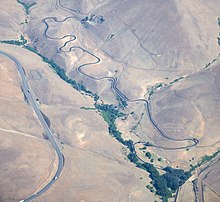
46:was an experimental road in south central
22:
15:
326:1911 establishments in Washington (state)
336:Washington (state) transportation stubs
150:
184:"Skateboarding Glides Into New Phase"
141:and street luge event is held there.
98:Spokane, Portland and Seattle Railway
7:
255:
253:
172:, February 4, 2000, pp. 54-56, 59-61
157:Robert W. Hadlow, Ph.D., Historian,
118:The design became the model for the
159:Oregon Department of Transportation
73:road in the state, it achieved low
14:
331:Western United States road stubs
257:
182:Higgins, Matt (July 20, 2010),
124:Historic Columbia River Highway
1:
133:The road is now owned by the
269:. You can help Knowledge by
69:. Laid in 1911 as the first
316:Roads in Washington (state)
352:
252:
50:, United States, built by
85:after World War II.
21:
230:45.72000°N 120.80000°W
135:Maryhill Museum of Art
35:Maryhill Museum of Art
321:Columbia River Gorge
235:45.72000; -120.80000
113:Maryhill, Washington
88:The road climbs the
226: /
67:Samuel C. Lancaster
64:landscape architect
44:Maryhill Loops Road
18:
17:Maryhill Loops Road
189:The New York Times
168:2008-03-27 at the
120:Figure-Eight Loops
278:
277:
109:utopian community
58:with the help of
40:
39:
343:
299:
292:
285:
261:
254:
241:
240:
238:
237:
236:
231:
227:
224:
223:
222:
219:
199:
198:
197:
196:
179:
173:
155:
79:horseshoe curves
26:
19:
351:
350:
346:
345:
344:
342:
341:
340:
306:
305:
304:
303:
250:
234:
232:
228:
225:
220:
217:
215:
213:
212:
208:
203:
202:
194:
192:
181:
180:
176:
170:Wayback Machine
156:
152:
147:
12:
11:
5:
349:
347:
339:
338:
333:
328:
323:
318:
308:
307:
302:
301:
294:
287:
279:
276:
275:
262:
248:
247:
242:
207:
206:External links
204:
201:
200:
174:
149:
148:
146:
143:
94:Columbia River
90:Columbia Hills
38:
37:
32:
28:
27:
13:
10:
9:
6:
4:
3:
2:
348:
337:
334:
332:
329:
327:
324:
322:
319:
317:
314:
313:
311:
300:
295:
293:
288:
286:
281:
280:
274:
272:
268:
263:
260:
256:
251:
246:
243:
239:
210:
209:
205:
191:
190:
185:
178:
175:
171:
167:
164:
160:
154:
151:
144:
142:
140:
136:
131:
129:
125:
121:
116:
114:
110:
107:
103:
99:
95:
91:
86:
84:
83:U.S. Route 97
80:
76:
72:
68:
65:
61:
57:
53:
49:
45:
36:
33:
31:Maintained by
29:
25:
20:
271:expanding it
264:
249:
193:, retrieved
187:
177:
153:
139:longboarding
132:
117:
87:
43:
41:
233: /
221:120°48′00″W
56:Samuel Hill
310:Categories
218:45°43′12″N
195:2010-09-05
145:References
52:Good Roads
48:Washington
92:from the
54:promoter
166:Archived
104:planned
60:engineer
122:on the
71:asphalt
128:Oregon
106:Quaker
102:Hill's
75:grades
211:Map:
77:with
267:stub
96:and
62:and
42:The
126:in
111:at
100:to
312::
186:,
161:,
115:.
298:e
291:t
284:v
273:.
Text is available under the Creative Commons Attribution-ShareAlike License. Additional terms may apply.