158:
led to the
Glendoe hydro-electric scheme above Fort Augustus. The actual reservoir and dam are not unduly intrusive, but the extensive network of heavy-duty access roads to service all the weirs diverting water into the catchment have altered its remoteness and wildness. These roads have also facilitated a very large wind energy project, one of several encouraged by proximity to the high-capacity Beauly-Denny power transmission line over Corrieyairack Pass, and which now dominate the NW Grampian skyline in views from the Cairngorms and Western Highlands up to 50 miles (80 kilometres) away.
22:
157:
The interior of the Monadh Liath is remote and desolate, with little remaining native tree cover. This is a result of human activity, deforestation and overgrazing by sheep and deer over the last thousand years, in common with much of the
Scottish Highlands. The renewable energy gold rush has already
153:
Although icesheets have repeatedly covered the Monadh Liath, they have done little to change its character: there are no corries away from the Munros fringe, and only a few short glaciated troughs, notably Glen Killin on the north. It has just become recognised that thin ice on the plateau is frozen
137:
The Monadh Liath differs greatly in character from the greater
Highland mountains to the south and west, as an elevated moorland with no proper ridges. The four Munros are all on the Spey rim, three making a classic circuit from Newtonmore; the interior is rarely visited. The main valley within the
145:
The landscape of the Monadh Liath is one of the most ancient in
Britain, its essentials as a secondary massif flanking the Cairngorms having evolved continuously since the Caledonian Mountains were created over 400 million years ago. Thus the land surface still slopes gently northwest towards the
154:
to the ground, but as it starts to flow into the troughs it thickens, accelerates, and warms up so it can erode and enlarge them. This has occurred as recently as the last (Younger Dryas) glacial period ~12000 years ago.
219:
David Jarman 'Landscape evolution of the
Monadhliath' (2013). In Boston CM, Lukas S and Merritt JW (eds) The Quaternary of the Monadhliath and the Great Glen - Field Guide. Quaternary Research Association, London,
229:
Clare Boston, Sven Lukas, Simon Carr 2015. A Younger Dryas plateau icefield in the
Monadhliath, Scotland, and implications for regional palaeoclimate. Quaternary Science Reviews 108, 139-162
302:
263:
307:
238:
131:
107:
82:, and means "grey mountain range". Running in a northeast to southwest direction, it lies on the western side of
103:
99:
119:
142:. It is unusually sinuous, being an incised meandering river valley very little altered by glaciers.
83:
127:
95:
123:
202:
35:
25:
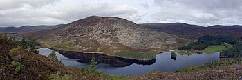
Part of the
Monadhliath Mountains, with Creag Mhor overlooking Loch Gynack in the foreground
21:
98:(763m) but similar uplands continue to Glen Roy and Spean Bridge. The range is within the
79:
139:
296:
175:
206:
147:
87:
278:
265:
110:, at 945 metres (3,100 ft), located 40 kilometres (25 mi) south of
111:
91:
130:(920 metres (3,020 ft)). The Monadhliath Mountains are designated a
75:
250:
150:, away from the main Grampian divide which crosses the Cairngorms.
115:
20:
59:
62:
50:
44:
47:
38:
56:
53:
41:
102:, and the south and east fringes are within the
94:. Its southwestern limit is usually taken to be
303:Mountains and hills of Highland (council area)
8:
239:Strategic deer management plan for 2015-2024
180:The Columbia Electronic Encyclopedia, 6th ed
193:Bremner, A (1939). "The River Findhorn".
167:
118:in the Monadhliath, the others being
7:
182:. Columbia University Press. 2007.
126:(926 metres (3,038 ft)), and
14:
106:. The high point of the range is
34:
195:Scottish Geographical Magazine
122:(930 metres (3,050 ft)),
74:, are a range of mountains in
1:
132:Special Area of Conservation
308:Mountain ranges of Scotland
324:
16:Mountain range in Scotland
207:10.1080/00369223908735107
90:and to the south east of
104:Cairngorms National Park
176:"Monadhliath Mountains"
114:. This is one of four
26:
100:Highland council area
86:, to the west of the
31:Monadhliath Mountains
24:
138:Monadh Liath is the
275: /
251:"Caledonian Forest"
96:Corrieyairack Pass
78:. Monadh Liath is
27:
315:
290:
289:
287:
286:
285:
280:
279:57.167°N 4.000°W
276:
273:
272:
271:
268:
255:
254:
247:
241:
236:
230:
227:
221:
217:
211:
210:
190:
184:
183:
172:
69:
68:
65:
64:
61:
58:
55:
52:
49:
46:
43:
40:
323:
322:
318:
317:
316:
314:
313:
312:
293:
292:
283:
281:
277:
274:
269:
266:
264:
262:
261:
259:
258:
249:
248:
244:
237:
233:
228:
224:
218:
214:
192:
191:
187:
174:
173:
169:
164:
80:Scottish Gaelic
37:
33:
17:
12:
11:
5:
321:
319:
311:
310:
305:
295:
294:
284:57.167; -4.000
257:
256:
242:
231:
222:
212:
185:
166:
165:
163:
160:
15:
13:
10:
9:
6:
4:
3:
2:
320:
309:
306:
304:
301:
300:
298:
291:
288:
252:
246:
243:
240:
235:
232:
226:
223:
216:
213:
208:
204:
200:
196:
189:
186:
181:
177:
171:
168:
161:
159:
155:
151:
149:
143:
141:
135:
133:
129:
125:
121:
117:
113:
109:
105:
101:
97:
93:
89:
85:
81:
77:
73:
67:
32:
23:
19:
260:
245:
234:
225:
215:
201:(2): 65–85.
198:
194:
188:
179:
170:
156:
152:
144:
136:
128:Càrn Sgulain
120:A'Chailleach
72:Monadh Liath
71:
30:
28:
18:
282: /
297:Categories
162:References
148:Great Glen
124:Geal Chàrn
108:Càrn Dearg
88:Cairngorms
84:Strathspey
112:Inverness
92:Loch Ness
140:Findhorn
76:Scotland
267:57°10′N
134:(SAC).
270:4°00′W
116:Munros
220:9-24.
70:, or
29:The
203:doi
299::
199:55
197:.
178:.
60:iː
45:oʊ
253:.
209:.
205::
66:/
63:ə
57:l
54:ˈ
51:ə
48:n
42:m
39:ˌ
36:/
Text is available under the Creative Commons Attribution-ShareAlike License. Additional terms may apply.