59:
22:
101:
forest. Various international organizations and financial institutions assist in watershed management, water resource management, establishment of water regulation, and river basin organizations for optimum use of water resources and watershed protection. One such project, the Nam Ngum River Basin
Development Sector Projects, has operated since 2002.
100:
The Nam Ngum river basin covers 16,906 square kilometers, including 8,297 km of watershed area. The Nam Ngum river basin covers 2.73 percent of the lower Mekong river basin. The water flow of the Nam Ngum River to the Mekong River is 700 m/s. Thirty percent of the river basin is covered by
93:
projects under construction or planned for construction on the Nam Ngum River. Tourism destinations along Nam Ngum include the Nam Ngum Lake, Dansavanh Nam Ngum Resort, and
279:
250:
115:, a type of ray-finned fish, is known to live only in the Nam Ngum drainage area. It is threatened by mining, pollution, and hydro-power development.
284:
269:
294:
243:
144:
289:
236:
274:
89:(Nam Ngum 1 Hydropower Project) was originally constructed between 1968 and 1971. There are also four other
75:
67:
190:
124:
111:
71:
220:
185:
81:
The Nam Ngum river basin is home to about one million people in Laos. The current largest
58:
263:
176:
167:
86:
47:
38:
33:
21:
94:
90:
152:
57:
20:
66:
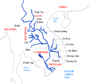
The Nam Ngum originates from the northern mountainous region of
43:
82:
224:
191:10.2305/IUCN.UK.2012-1.RLTS.T181035A1691255.en
244:
219:This article related to a river in Laos is a
8:
74:joining the Mekong at the capital of Laos,
251:
237:
189:
136:
37:
7:
216:
214:
177:IUCN Red List of Threatened Species
280:Geography of Xiangkhouang province
223:. You can help Knowledge (XXG) by
14:
46:. It is a major tributary of the
42:) is a 354 km long river in
285:Geography of Vientiane province
270:Tributaries of the Mekong River
25:Location of the Nam Ngum River
1:
311:
213:
70:and flows south through
62:A boat on Nam Ngum Lake
63:
26:
184:: e.T181035A1691255.
166:Kottelat, M. (2012).
61:
24:
295:Laos geography stubs
68:Xiangkhoang Province
170:Hemimyzon confluens
125:Ban Phou Pheung Noi
112:hemimyzon confluens
39:[nâːmŋɯ́ːm]
72:Vientiane Province
64:
27:
232:
231:
302:
290:Asia river stubs
253:
246:
239:
215:
203:
202:
200:
198:
193:
163:
157:
156:
155:on 9 April 2008.
151:. Archived from
141:
41:
310:
309:
305:
304:
303:
301:
300:
299:
260:
259:
258:
257:
211:
207:
206:
196:
194:
165:
164:
160:
145:"Laos in brief"
143:
142:
138:
133:
121:
107:
56:
17:
12:
11:
5:
308:
306:
298:
297:
292:
287:
282:
277:
275:Rivers of Laos
272:
262:
261:
256:
255:
248:
241:
233:
230:
229:
205:
204:
158:
135:
134:
132:
129:
128:
127:
120:
117:
106:
103:
55:
52:
15:
13:
10:
9:
6:
4:
3:
2:
307:
296:
293:
291:
288:
286:
283:
281:
278:
276:
273:
271:
268:
267:
265:
254:
249:
247:
242:
240:
235:
234:
228:
226:
222:
217:
212:
209:
192:
187:
183:
179:
178:
173:
171:
162:
159:
154:
150:
146:
140:
137:
130:
126:
123:
122:
118:
116:
114:
113:
104:
102:
98:
96:
92:
88:
85:on Nam Ngum,
84:
79:
77:
73:
69:
60:
53:
51:
49:
45:
40:
35:
31:
23:
19:
16:River in Laos
225:expanding it
218:
210:
208:
195:. Retrieved
181:
175:
169:
161:
153:the original
148:
139:
110:
108:
99:
87:Nam Ngum Dam
80:
65:
48:Mekong River
29:
28:
18:
264:Categories
197:15 January
149:www.un.int
131:References
95:Vang Vieng
91:hydropower
36:: ນໍ້າງືມ
76:Vientiane
54:Geography
119:See also
105:Wildlife
30:Nam Ngum
34:Laotian
221:stub
199:2018
182:2012
109:The
44:Laos
186:doi
83:dam
266::
180:.
174:.
147:.
97:.
78:.
50:.
252:e
245:t
238:v
227:.
201:.
188::
172:"
168:"
32:(
Text is available under the Creative Commons Attribution-ShareAlike License. Additional terms may apply.