Download coordinates as:

There are 459 properties and historic districts listed on the National Register of Historic Places in North Dakota. There are listings in 52 of North Dakota's 53 counties.
| Adams | Barnes | Benson | Billings | Bottineau | Bowman | Burke | Burleigh | Cass | Cavalier | Dickey | Divide | Dunn | Eddy | Emmons | Foster | Golden Valley | Grand Forks | Grant | Griggs | Hettinger | Kidder | LaMoure | Logan | McHenry | McIntosh | McKenzie | McLean | Mercer | Morton | Mountrail | Nelson | Oliver | Pembina | Pierce | Ramsey | Ransom | Renville | Richland | Rolette | Sargent | Sheridan | Sioux | Slope | Stark | Steele | Stutsman | Towner | Traill | Walsh | Ward | Wells | Williams |
This National Park Service list is complete through NPS recent listings posted September 13, 2024.
Current listings by county


The following are approximate tallies of current listings by county. These counts are based on entries in the National Register Information Database as of April 24, 2008 and new weekly listings posted since then on the National Register of Historic Places web site. There are frequent additions to the listings and occasional delistings and the counts here are approximate and not official. New entries are added to the official Register on a weekly basis. Also, the counts in this table exclude boundary increase and decrease listings which modify the area covered by an existing property or district and which carry a separate National Register reference number. The numbers of NRHP listings in each county are documented by tables in each of the individual county list-articles.
| County | # of Sites | Region | |
|---|---|---|---|
| 1 | Adams | 3 | Missouri Plateau |
| 2 | Barnes | 13 | Drift Prairie |
| 3 | Benson | 7 | Drift Prairie |
| 4 | Billings | 11 | Missouri Plateau |
| 5 | Bottineau | 4 | Drift Prairie |
| 6 | Bowman | 2 | Missouri Plateau |
| 7 | Burke | 4 | Drift Prairie |
| 8 | Burleigh | 27 | Missouri Plateau |
| 9 | Cass | 38 | Red River Valley |
| 10 | Cavalier | 3 | Drift Prairie |
| 11 | Dickey | 8 | Drift Prairie |
| 12 | Divide | 5 | Missouri Plateau |
| 13 | Dunn | 4 | Missouri Plateau |
| 14 | Eddy | 4 | Drift Prairie |
| 15 | Emmons | 17 | Missouri Plateau |
| 16 | Foster | 6 | Drift Prairie |
| 17 | Golden Valley | 2 | Missouri Plateau |
| 18 | Grand Forks | 69 | Red River Valley |
| 19 | Grant | 4 | Missouri Plateau |
| 20 | Griggs | 4 | Drift Prairie |
| 21 | Hettinger | 6 | Missouri Plateau |
| 22 | Kidder | 4 | Missouri Plateau |
| 23 | LaMoure | 2 | Drift Prairie |
| 24 | Logan | 2 | Missouri Plateau |
| 25 | McHenry | 12 | Drift Prairie |
| 26 | McIntosh | 8 | Missouri Plateau |
| 27 | McKenzie | 4 | Missouri Plateau |
| 28 | McLean | 8 | Missouri Plateau |
| 29 | Mercer | 8 | Missouri Plateau |
| 30 | Morton | 10 | Missouri Plateau |
| 31 | Mountrail | 5 | Missouri Plateau |
| 32 | Nelson | 4 | Drift Prairie |
| 33 | Oliver | 1 | Missouri Plateau |
| 34 | Pembina | 13 | Red River Valley |
| 35 | Pierce | 7 | Drift Prairie |
| 36 | Ramsey | 15 | Drift Prairie |
| 37 | Ransom | 9 | Drift Prairie |
| 38 | Renville | 2 | Drift Prairie |
| 39 | Richland | 12 | Red River Valley |
| 40 | Rolette | 3 | Drift Prairie |
| 41 | Sargent | 1 | Drift Prairie |
| 42 | Sheridan | 2 | Missouri Plateau |
| 43 | Sioux | 0 | Missouri Plateau |
| 44 | Slope | 2 | Missouri Plateau |
| 45 | Stark | 5 | Missouri Plateau |
| 46 | Steele | 3 | Drift Prairie |
| 47 | Stutsman | 10 | Drift Prairie |
| 48 | Towner | 1 | Drift Prairie |
| 49 | Traill | 22 | Red River Valley |
| 50 | Walsh | 16 | Red River Valley |
| 51 | Ward | 15 | Drift Prairie |
| 52 | Wells | 6 | Drift Prairie |
| 53 | Williams | 8 | Missouri Plateau |
| (duplicates) | (3) | ||
| TOTAL | 458 | ||
| Name on the Register | Image | Date listed | Location | City or town | Description | |
|---|---|---|---|---|---|---|
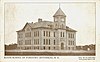
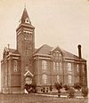
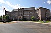
| 1 | Adams County Courthouse |  |
November 14, 1985 (#85002977) |
600 Adams Ave. 46°00′05″N 102°38′04″W / 46.001389°N 102.634444°W / 46.001389; -102.634444 (Adams County Courthouse) | Hettinger | |
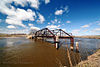
| 2 | Cedar Creek Bridge | 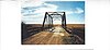 |
February 27, 1997 (#97000168) |
Unnamed county road across Cedar Creek, approximately 6 miles north and 11 miles east of Haynes 46°03′02″N 102°13′37″W / 46.050556°N 102.226944°W / 46.050556; -102.226944 (Cedar Creek Bridge) | Haynes | |
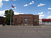
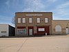
| 3 | United States Post Office-Hettinger | Upload image | November 1, 1989 (#89001751) |
Lake St. and Adams Ave. 46°00′05″N 102°38′10″W / 46.001389°N 102.636111°W / 46.001389; -102.636111 (United States Post Office-Hettinger) | Hettinger |


| Name on the Register | Image | Date listed | Location | City or town | Description | |
|---|---|---|---|---|---|---|
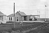
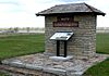
| 1 | Fort Dilts | 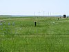 |
November 10, 1980 (#80002907) |
Fort Dilts Road 46°16′43″N 103°46′33″W / 46.278611°N 103.775833°W / 46.278611; -103.775833 (Fort Dilts) | Rhame | |
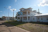
| 2 | Emma Petznick and Otto Schade House | Upload image | April 16, 2008 (#08000313) |
406 W. Divide 46°10′56″N 103°24′04″W / 46.1822°N 103.401006°W / 46.1822; -103.401006 (Emma Petznick and Otto Schade House) | Bowman |
| Name on the Register | Image | Date listed | Location | City or town | Description | |
|---|---|---|---|---|---|---|
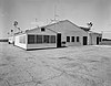
| 1 | Burke County Courthouse | 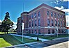 |
November 14, 1985 (#85002979) |
Main St. 48°48′03″N 102°14′53″W / 48.800833°N 102.248056°W / 48.800833; -102.248056 (Burke County Courthouse) | Bowbells | |
| 2 | Burke County World War Memorial Hall |  |
January 4, 2018 (#100001952) |
101 1st St. 48°53′58″N 102°23′36″W / 48.899389°N 102.393207°W / 48.899389; -102.393207 (Burke County World War Memorial Hall) | Flaxton | |
| 3 | William E. Metzger House | Upload image | August 22, 2007 (#07000841) |
112 Makee St. 48°59′49″N 102°33′11″W / 48.997037°N 102.553056°W / 48.997037; -102.553056 (William E. Metzger House) | Portal | |
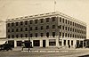
| 4 | Portal State Bank |  |
October 3, 1996 (#96001067) |
19 Main St. 48°59′45″N 102°32′54″W / 48.995833°N 102.548333°W / 48.995833; -102.548333 (Portal State Bank) | Portal |
Former listing
| Name on the Register | Image | Date listed | Date removed | Location | City or town | Description | |
|---|---|---|---|---|---|---|---|
| 1 | Flaxton Hotel | Upload image | August 16, 1977 (#77001019) | June 30, 1987 | Davis St. | Flaxton |
| Name on the Register | Image | Date listed | Location | City or town | Description | |
|---|---|---|---|---|---|---|
| 1 | Roxy Theatre | 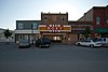 |
November 18, 1998 (#98001341) |
714 3rd St. 48°45′35″N 98°22′06″W / 48.759722°N 98.368333°W / 48.759722; -98.368333 (Roxy Theatre) | Langdon | |
| 2 | RSL-3 |  |
October 23, 2018 (#100003053) |
12329 ND 5 48°45′41″N 97°57′00″W / 48.7613°N 97.9500°W / 48.7613; -97.9500 (RSL-3) | Concrete vicinity | Remote Sprint Launch facility, part of the Safeguard missile defense program. |
| 3 | US Post Office-Langdon | Upload image | November 1, 1989 (#89001752) |
323 8th Ave. 48°45′41″N 98°22′08″W / 48.761389°N 98.368889°W / 48.761389; -98.368889 (US Post Office-Langdon) | Langdon |


| Name on the Register | Image | Date listed | Location | City or town | Description | |
|---|---|---|---|---|---|---|
| 1 | Hutmacher Farm | Upload image | December 17, 1979 (#79001772) |
Northwest of Manning 47°16′45″N 102°55′39″W / 47.279167°N 102.9275°W / 47.279167; -102.9275 (Hutmacher Farm) | Manning | |
| 2 | Independence Congregational Church | Upload image | July 14, 2015 (#15000422) |
BIA Rd. 13, Fort Berthold Indian Reservation 47°41′40″N 102°22′35″W / 47.6945°N 102.3763°W / 47.6945; -102.3763 (Independence Congregational Church) | Mandaree vicinity | |
| 3 | Lynch Quarry Site |  |
July 13, 2011 (#11000629) |
448 95th Ave., SW. 47°21′09″N 102°33′22″W / 47.352500°N 102.556111°W / 47.352500; -102.556111 (Lynch Quarry Site) | Dunn Center | |
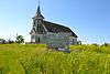
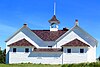
| 4 | Saints Peter and Paul Church | 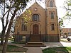 |
February 3, 1986 (#86000161) |
101 Lafayette St. 47°00′02″N 102°53′01″W / 47.000556°N 102.883611°W / 47.000556; -102.883611 (Saints Peter and Paul Church) | New Hradec |
Former listing
| Name on the Register | Image | Date listed | Date removed | Location | City or town | Description | |
|---|---|---|---|---|---|---|---|
| 1 | Dunn County Courthouse | Upload image | March 26, 1986 (#86000620) | October 21, 2009 | Owens St. 47°13′53″N 102°46′10″W / 47.2314°N 102.7694°W / 47.2314; -102.7694 (Dunn County Courthouse) | Manning | Demolished in 1996. |
| Name on the Register | Image | Date listed | Location | City or town | Description | |
|---|---|---|---|---|---|---|
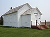
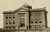
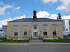
| 1 | Eddy County Courthouse |  |
November 14, 1985 (#85002981) |
524 Central Ave. 47°40′49″N 99°08′03″W / 47.680278°N 99.134167°W / 47.680278; -99.134167 (Eddy County Courthouse) | New Rockford | |
| 2 | Sylvanus Marriage Octagonal Barn | Upload image | October 7, 1986 (#86002748) |
ND 38 47°36′50″N 99°05′50″W / 47.613889°N 99.097222°W / 47.613889; -99.097222 (Sylvanus Marriage Octagonal Barn) | New Rockford | |
| 3 | New Rockford Bridge | Upload image | March 13, 1997 (#97000173) |
Across the James River, unnamed county road at its junction with ND 15 47°41′08″N 99°08′05″W / 47.685556°N 99.134722°W / 47.685556; -99.134722 (New Rockford Bridge) | New Rockford | |
| 4 | US Post Office-New Rockford |  |
November 1, 1989 (#89001750) |
821 N. 1st Ave. 47°40′51″N 99°08′21″W / 47.680833°N 99.139167°W / 47.680833; -99.139167 (US Post Office-New Rockford) | New Rockford |
Former listing
| Name on the Register | Image | Date listed | Date removed | Location | City or town | Description | |
|---|---|---|---|---|---|---|---|
| 1 | Jens Myhre Round Barn | Upload image | October 1, 1986 (#86002749) | July 14, 2015 | ND 30 47°44′46″N 99°12′11″W / 47.746111°N 99.203056°W / 47.746111; -99.203056 (Jens Myhre Round Barn) | New Rockford |


Former listing
| Name on the Register | Image | Date listed | Date removed | Location | City or town | Description | |
|---|---|---|---|---|---|---|---|
| 1 | Lincoln Building | Upload image | April 30, 1980 (#80002912) | February 1, 2011 | Off U.S. Route 281 47°27′07″N 99°07′22″W / 47.4519°N 99.1228°W / 47.4519; -99.1228 (Lincoln Building) | Carrington |
| Name on the Register | Image | Date listed | Location | City or town | Description | |
|---|---|---|---|---|---|---|
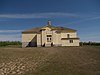
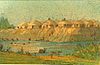
| 1 | Custer Military Trail Historic Archaeological District |  |
June 5, 2009 (#08001293) |
Multiple locations south and west of Medora | Sentinel Butte | Includes sites in Billings County. |
| 2 | Golden Valley County Courthouse | 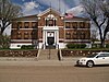 |
November 14, 1985 (#85002983) |
First Ave., SE. 46°54′48″N 104°00′14″W / 46.913333°N 104.003889°W / 46.913333; -104.003889 (Golden Valley County Courthouse) | Beach |
Former listings
| Name on the Register | Image | Date listed | Date removed | Location | City or town | Description | |
|---|---|---|---|---|---|---|---|
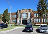
| 1 | Sentinel Butte Public School |  |
October 21, 1982 (#82001313) | November 15, 2023 | Byron St. 46°55′03″N 103°50′19″W / 46.9175°N 103.838611°W / 46.9175; -103.838611 (Sentinel Butte Public School) | Sentinel Butte |


| Name on the Register | Image | Date listed | Location | City or town | Description | |
|---|---|---|---|---|---|---|
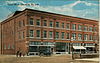
| 1 | Dagen's Grocery | 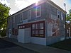 |
July 6, 2005 (#05000659) |
616 Central Ave. 46°31′38″N 98°53′49″W / 46.527222°N 98.896944°W / 46.527222; -98.896944 (Dagen's Grocery) | Jud | |
| 2 | La Moure County Courthouse |  |
November 25, 1980 (#80004284) |
In LaMoure 46°21′45″N 98°17′28″W / 46.3625°N 98.291111°W / 46.3625; -98.291111 (La Moure County Courthouse) | LaMoure |
Former listing
| Name on the Register | Image | Date listed | Date removed | Location | City or town | Description | |
|---|---|---|---|---|---|---|---|
| 1 | Rodman Octagonal Barn | Upload image | October 7, 1986 (#86002753) | July 14, 2015 | ND 30 46°24′33″N 98°47′17″W / 46.409167°N 98.788056°W / 46.409167; -98.788056 (Rodman Octagonal Barn) | Edgeley |
| Name on the Register | Image | Date listed | Location | City or town | Description | |
|---|---|---|---|---|---|---|
| 1 | Robert Abell Round Barn | Upload image | October 7, 1986 (#86002754) |
ND 38 46°22′35″N 99°28′29″W / 46.376389°N 99.474722°W / 46.376389; -99.474722 (Robert Abell Round Barn) | Burnstad | |
| 2 | Logan County Courthouse | Upload image | November 14, 1985 (#85002986) |
301 Broadway 46°30′12″N 99°46′06″W / 46.503333°N 99.768333°W / 46.503333; -99.768333 (Logan County Courthouse) | Napoleon |


Former listing
| Name on the Register | Image | Date listed | Date removed | Location | City or town | Description | |
|---|---|---|---|---|---|---|---|
| 1 | Old Wishek City Hall | 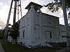 |
October 4, 2005 (#05001141) | July 14, 2015 | 21 Centennial St. 46°15′30″N 99°33′28″W / 46.258333°N 99.557778°W / 46.258333; -99.557778 (Old Wishek City Hall) | Wishek | Demolished c. 2011. |


Former listings
| Name on the Register | Image | Date listed | Date removed | Location | City or town | Description | |
|---|---|---|---|---|---|---|---|
| 1 | Former McLean County Courthouse | 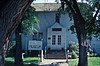 |
November 14, 1985 (#85002987) | December 23, 2021 | Main St. 47°17′23″N 101°01′44″W / 47.289722°N 101.028889°W / 47.289722; -101.028889 (Former McLean County Courthouse) | Washburn | |
| 2 | McLean County Courthouse |  |
November 14, 1985 (#85002998) | June 15, 2013 | 5th Ave. 47°17′27″N 101°01′34″W / 47.290833°N 101.026111°W / 47.290833; -101.026111 (McLean County Courthouse) | Washburn | Demolished in 2013. |


Former listing
| Name on the Register | Image | Date listed | Date removed | Location | City or town | Description | |
|---|---|---|---|---|---|---|---|
| 1 | Hazen High School | Upload image | August 12, 1977 (#77001026) | March 15, 1991 | 400 Central Ave. | Hazen |


Former listing
| Name on the Register | Image | Date listed | Date removed | Location | City or town | Description | |
|---|---|---|---|---|---|---|---|
| 1 | State Training School Historic District | Upload image | January 19, 1996 (#95001549) | July 16, 2018 | Western bank of the Heart River, 0.5 miles south of W. Main St., on the western edge of Mandan 46°48′32″N 100°54′49″W / 46.808889°N 100.913611°W / 46.808889; -100.913611 (State Training School Historic District) | Mandan |


| Name on the Register | Image | Date listed | Location | City or town | Description | |
|---|---|---|---|---|---|---|
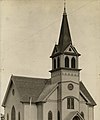
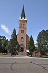
| 1 | Episcopal Church of the Good Shepard-Lakota |  |
October 10, 2017 (#100001743) |
216 D Ave. W. 48°02′37″N 98°20′44″W / 48.043654°N 98.345462°W / 48.043654; -98.345462 (Episcopal Church of the Good Shepard-Lakota) | Lakota | |
| 2 | Nesheim Bridge | Upload image | February 27, 1997 (#97000185) |
Unnamed county road across the Sheyenne River, approximately 2 miles southwest of McVille 47°44′15″N 98°13′06″W / 47.7375°N 98.218333°W / 47.7375; -98.218333 (Nesheim Bridge) | McVille | |
| 3 | Old Settler's Pavilion | Upload image | June 12, 2010 (#10000366) |
63 Pavilion Rd. 47°52′13″N 98°21′20″W / 47.870310°N 98.355484°W / 47.870310; -98.355484 (Old Settler's Pavilion) | Pekin | |
| 4 | Tofthagen Library Museum |  |
September 26, 1991 (#91001467) |
116 W. B Ave. 48°02′30″N 98°20′41″W / 48.041667°N 98.344722°W / 48.041667; -98.344722 (Tofthagen Library Museum) | Lakota |
| Name on the Register | Image | Date listed | Location | City or town | Description | |
|---|---|---|---|---|---|---|
| 1 | Cross Ranch Archeological District | Upload image | November 4, 1985 (#85003484) |
Cross Ranch Nature Preserve 47°13′00″N 101°00′00″W / 47.216667°N 101°W / 47.216667; -101 (Cross Ranch Archeological District) | Hensler |


| Name on the Register | Image | Date listed | Location | City or town | Description | |
|---|---|---|---|---|---|---|
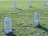
| 1 | McKinney Cemetery | Upload image | December 28, 1978 (#78001994) |
North of Tolley 48°45′33″N 101°47′01″W / 48.759231°N 101.783556°W / 48.759231; -101.783556 (McKinney Cemetery) | Tolley | |
| 2 | Renville County Courthouse | 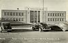 |
November 25, 1985 (#85002989) |
Main St. 48°45′49″N 101°30′32″W / 48.763611°N 101.508889°W / 48.763611; -101.508889 (Renville County Courthouse) | Mohall |
| Name on the Register | Image | Date listed | Location | City or town | Description | |
|---|---|---|---|---|---|---|
| 1 | Urbain Cote Round Barn | 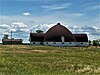 |
October 7, 1986 (#86002755) |
ND 38 47°38′40″N 100°03′30″W / 47.644444°N 100.058333°W / 47.644444; -100.058333 (Urbain Cote Round Barn) | Dunseith | |
| 2 | Coghlan Castle |  |
July 16, 2008 (#08000681) |
Lot 2, SW 1/4 of the NW 1/4 T163N R69W Section 19 48°55′49″N 99°39′18″W / 48.9303°N 99.655°W / 48.9303; -99.655 (Coghlan Castle) | St. John | |
| 3 | U.S. Inspection Station-St. John, North Dakota |  |
September 10, 2014 (#14000588) |
ND 30 48°59′56″N 99°39′31″W / 48.9988°N 99.6585°W / 48.9988; -99.6585 (U.S. Inspection Station-St. John, North Dakota) | St. John |
| Name on the Register | Image | Date listed | Location | City or town | Description | |
|---|---|---|---|---|---|---|
| 1 | Sargent County Courthouse | 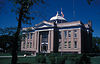 |
November 25, 1980 (#80002927) |
355 Main St S 46°06′23″N 97°38′13″W / 46.106389°N 97.636944°W / 46.106389; -97.636944 (Sargent County Courthouse) | Forman |
| Name on the Register | Image | Date listed | Location | City or town | Description | |
|---|---|---|---|---|---|---|
| 1 | Clark House | Upload image | June 25, 2013 (#13000453) |
322 McKinley Ave 47°28′27″N 100°07′37″W / 47.47421°N 100.12688°W / 47.47421; -100.12688 (Clark House) | Goodrich | |
| 2 | Sheridan County Courthouse | 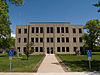 |
November 25, 1985 (#85002990) |
215 E. 2nd St. 47°29′04″N 100°26′25″W / 47.484444°N 100.440278°W / 47.484444; -100.440278 (Sheridan County Courthouse) | McClusky |
Former listing
| Name on the Register | Image | Date listed | Date removed | Location | City or town | Description | |
|---|---|---|---|---|---|---|---|
| 1 | Winter House | Upload image | November 29, 1979 (#79001775) | April 1, 2009 | Northeastern Sheridan County 47°38′12″N 100°05′01″W / 47.6367°N 100.0836°W / 47.6367; -100.0836 (Winter House) | Goodrich |
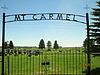
Sioux County has no current listings on the National Register.
Former listing
| Name on the Register | Image | Date listed | Date removed | Location | City or town | Description | |
|---|---|---|---|---|---|---|---|
| 1 | Former Sioux County Courthouse |  |
November 19, 1985 (#85002993) | October 21, 2009 | Belden St. 46°05′08″N 100°37′51″W / 46.0856°N 100.6308°W / 46.0856; -100.6308 (Former Sioux County Courthouse) | Fort Yates | NRHP nomination termed this "rather plain" but suggested it was worthwhile to list in order to promote local awareness of historic preservation, given no nearby NRHP listings |
| Name on the Register | Image | Date listed | Location | City or town | Description | |
|---|---|---|---|---|---|---|
| 1 | H-T Ranch | Upload image | July 5, 1985 (#85001491) |
10 miles west of Amidon 46°29′22″N 103°31′56″W / 46.489444°N 103.532222°W / 46.489444; -103.532222 (H-T Ranch) | Amidon | |
| 2 | Mystic Theatre |  |
September 13, 1977 (#77001029) |
Main St. 46°17′49″N 103°55′29″W / 46.296944°N 103.924722°W / 46.296944; -103.924722 (Mystic Theatre) | Marmarth |
Former listing
| Name on the Register | Image | Date listed | Date removed | Location | City or town | Description | |
|---|---|---|---|---|---|---|---|
| 1 | Original Slope County Courthouse |  |
November 14, 1985 (#85002994) | April 3, 2015 | 2nd St. 46°28′54″N 103°19′19″W / 46.481667°N 103.321944°W / 46.481667; -103.321944 (Original Slope County Courthouse) | Amidon | Was the last standing wooden courthouse in North Dakota. Demolished in October 2014. |


Former listing
| Name on the Register | Image | Date listed | Date removed | Location | City or town | Description | |
|---|---|---|---|---|---|---|---|
| 1 | Gerhardt Octagonal Pig House | Upload image | October 7, 1986 (#86002758) | July 14, 2015 | ND 38 46°52′28″N 102°29′37″W / 46.874444°N 102.493611°W / 46.874444; -102.493611 (Gerhardt Octagonal Pig House) | Gladstone |
| Name on the Register | Image | Date listed | Location | City or town | Description | |
|---|---|---|---|---|---|---|
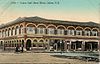
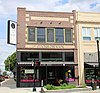
| 1 | Baldwin's Arcade |  |
February 18, 1975 (#75001306) |
Steele Ave. and 3rd St. 47°19′21″N 97°43′15″W / 47.3225°N 97.720833°W / 47.3225; -97.720833 (Baldwin's Arcade) | Hope | |
| 2 | Beaver Creek Bridge | Upload image | February 27, 1997 (#97000183) |
Unnamed county road across Beaver Creek, approximately 13 miles east and 4 miles north of Finley 47°35′16″N 97°33′28″W / 47.587778°N 97.557778°W / 47.587778; -97.557778 (Beaver Creek Bridge) | Finley | |
| 3 | Steele County Courthouse | 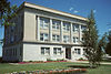 |
November 14, 1985 (#85002995) |
201 Washington Ave. 47°30′52″N 97°50′16″W / 47.514444°N 97.837778°W / 47.514444; -97.837778 (Steele County Courthouse) | Finley |
| Name on the Register | Image | Date listed | Location | City or town | Description | |
|---|---|---|---|---|---|---|
| 1 | Towner County Courthouse |  |
November 14, 1985 (#85002996) |
2nd St., S. 48°29′36″N 99°12′20″W / 48.493333°N 99.205556°W / 48.493333; -99.205556 (Towner County Courthouse) | Cando |


See also
- List of National Historic Landmarks in North Dakota
- List of bridges on the National Register of Historic Places in North Dakota
References
- National Park Service, United States Department of the Interior, "National Register of Historic Places: Weekly List Actions", retrieved September 13, 2024.
- ^ "National Register Information System". National Register of Historic Places. National Park Service. April 24, 2008.
- "National Register of Historic Places: Weekly List Actions". National Park Service. Archived from the original on January 26, 2011. Retrieved January 2, 2009.
- Weekly List Actions, National Register of Historic Places website
- Ridge Trail Historic District is listed in both Walsh and Pembina counties. Fort Union Trading Post National Historic Site is listed in both McKenzie and Williams counties (as well as Richland and Roosevelt counties, Montana). Custer Military Trail Historic Archaeological District is listed in Billings and Golden Valley counties.
- ^ Numbers represent an alphabetical ordering by significant words. Various colorings, defined here, differentiate National Historic Landmarks and historic districts from other NRHP buildings, structures, sites or objects.
- ^ The eight-digit number below each date is the number assigned to each location in the National Register Information System database, which can be viewed by clicking the number.
- Hiemstra, Damita. National Historic Landmark Nomination/Registration: Lynch Quarry Site. National Park Service, 2008-06, 1.
- "Dunn Center Quarry becomes historic landmark | the Dickinson Press | Dickinson, North Dakota". Archived from the original on June 2, 2013. Retrieved July 29, 2011.
- Diocese of Bismarck. "Diocese of Bismarck 2013 Catholic Directory ", 2013, 10. Accessed 2013-05-01.
- "Medicine Rock". Geographic Names Information System. United States Geological Survey, United States Department of the Interior.
- "Oscar Zero Missile Alert Facility & November-33 Missile Launch Facility". State Historical Society of North Dakota. Archived from the original on August 21, 2008. Retrieved January 17, 2009.
- "Tumbling down". The Bismarck Tribune. April 19, 2013. p. 1. Retrieved August 11, 2022 – via Newspapers.com.
- http://www.grandforksherald.com/event/article/id/261681/group/homepage/
- "N.D. Voters to decide McLean County Courthouse's future".
- Weston, Timothy. "Acculturation in the Middle Missouri Valley as Reflected in Modified Bone Assemblages". Plains Anthropologist 38.142 (1993): 79-100: 80.
- Wood, W. Raymond. "Pottery Types from the Biesterfeldt Site, North Dakota". Plains Anthropologist 3 (1955): 3-12: 3.
- http://www.thedickinsonpress.com/content/historic-slope-county-courthouse-dismantled

| Topics | |
|---|---|
| Lists by state |
|
| Lists by insular areas | |
| Lists by associated state | |
| Other areas | |
| Related | |
