Name on the Register
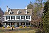
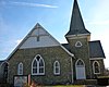
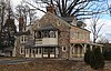
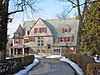
Image
Date listed
Location
Municipality
Description
1
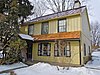
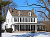
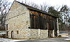
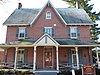
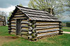
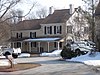
David Ashbridge Log House David Ashbridge Log House November 6, 1984 (#84003878 ) 1181 King Road 40°01′06″N 75°35′21″W / 40.018333°N 75.589167°W / 40.018333; -75.589167 (David Ashbridge Log House ) West Whiteland Township
2
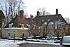
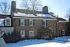
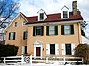
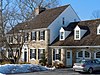
Autun Autun September 6, 1984 (#84003232 ) 371 East Boot Road 40°00′39″N 75°36′21″W / 40.010833°N 75.605833°W / 40.010833; -75.605833 (Autun ) West Whiteland Township
3
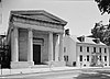
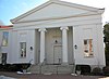
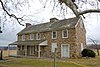
Bank of Chester County Bank of Chester County June 5, 1972 (#02001458 ) 17 North High Street 39°57′37″N 75°36′17″W / 39.96026°N 75.604741°W / 39.96026; -75.604741 (Bank of Chester County ) West Chester
4
Barclay House Barclay House April 18, 2002 (#02000380 ) 535 and 539 North Church Street 39°57′55″N 75°36′35″W / 39.965169°N 75.609837°W / 39.965169; -75.609837 (Barclay House ) West Chester
5
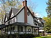
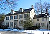
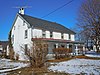
William J. Barnard Residence William J. Barnard Residence July 21, 1982 (#82003779 ) 920 East Street Road 39°55′59″N 75°32′46″W / 39.933056°N 75.546111°W / 39.933056; -75.546111 (William J. Barnard Residence ) Thornbury Township
6
Bartram's Covered Bridge Bartram's Covered Bridge December 10, 1980 (#80003462 ) West of Newtown on Legislative Route 15098 39°59′23″N 75°26′15″W / 39.989722°N 75.4375°W / 39.989722; -75.4375 (Bartram's Covered Bridge ) Willistown Township Extends into Newtown Township in Delaware County
7
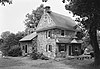
John Bell Farm John Bell Farm September 6, 1984 (#84003235 ) 463 North Ship Road 40°02′39″N 75°37′17″W / 40.044167°N 75.621389°W / 40.044167; -75.621389 (John Bell Farm ) West Whiteland Township
8
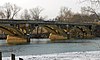
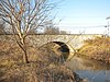
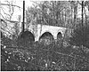
Black Rock Bridge Black Rock Bridge June 22, 1988 (#88000735 ) Pennsylvania Route 113 over the Schuylkill River 40°09′32″N 75°30′44″W / 40.158889°N 75.512222°W / 40.158889; -75.512222 (Black Rock Bridge ) Phoenixville Extends into Upper Providence Township in Montgomery County
9
Riter Boyer House Riter Boyer House November 10, 1983 (#83004207 ) 350 West Boot Road 40°00′21″N 75°37′48″W / 40.005833°N 75.63°W / 40.005833; -75.63 (Riter Boyer House ) West Whiteland Township
10
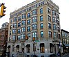
Buckwalter Building Buckwalter Building February 22, 1984 (#84003180 ) 11–13 South High Street 39°57′34″N 75°36′15″W / 39.959483°N 75.604043°W / 39.959483; -75.604043 (Buckwalter Building ) West Chester
11
Butler House Butler House July 23, 1980 (#80003470 ) 228 West Miner Street 39°57′25″N 75°36′26″W / 39.956876°N 75.607172°W / 39.956876; -75.607172 (Butler House ) West Chester
12
Charlestown Village Historic District Charlestown Village Historic District May 16, 1978 (#78002374 ) Southwest of Phoenixville on Charlestown Road 40°05′58″N 75°33′24″W / 40.099444°N 75.556667°W / 40.099444; -75.556667 (Charlestown Village Historic District ) Charlestown Township
13
Squire Cheyney Farm Squire Cheyney Farm January 11, 2010 (#09001214 ) 1255 Cheyney Thornton Road 39°59′17″N 75°31′22″W / 39.988056°N 75.522778°W / 39.988056; -75.522778 (Squire Cheyney Farm ) Thornbury Township
14
Chester County Courthouse Chester County Courthouse June 5, 1972 (#72001109 ) 10 North High Street 39°57′35″N 75°36′18″W / 39.959861°N 75.605°W / 39.959861; -75.605 (Chester County Courthouse ) West Chester
15
Church Farm School Historic District Church Farm School Historic District October 26, 1984 (#84002733 ) U.S. Route 30 40°01′54″N 75°35′41″W / 40.031667°N 75.594722°W / 40.031667; -75.594722 (Church Farm School Historic District ) West Whiteland Township
16
Moses Coates Jr. Farm Moses Coates Jr. Farm May 3, 1984 (#84003186 ) 1416 State Road 40°06′58″N 75°31′23″W / 40.116111°N 75.523056°W / 40.116111; -75.523056 (Moses Coates Jr. Farm ) Schuylkill Township
17
Colebrook Manor Colebrook Manor September 6, 1984 (#84003239 ) 637 West Lincoln Highway near Exton 40°01′22″N 75°39′52″W / 40.022778°N 75.664444°W / 40.022778; -75.664444 (Colebrook Manor ) West Whiteland Township
18
Collins Mansion Collins Mansion November 9, 1972 (#72001110 ) 633 Goshen Road 39°58′31″N 75°36′12″W / 39.975254°N 75.603384°W / 39.975254; -75.603384 (Collins Mansion ) West Goshen Township
19
County Bridge No. 148 County Bridge No. 148 June 22, 1988 (#88000879 ) Pennsylvania Route 926 over Chester Creek, near Westtown39°55′54″N 75°33′06″W / 39.931667°N 75.551667°W / 39.931667; -75.551667 (County Bridge No. 148 ) Westtown Township
20
County Bridge No. 171 County Bridge No. 171 June 22, 1988 (#88000762 ) Cedar Hollow Road over Valley Creek 40°03′12″N 75°30′03″W / 40.053333°N 75.500833°W / 40.053333; -75.500833 (County Bridge No. 171 ) Tredyffrin Township
21
Hewson Cox House Hewson Cox House August 2, 1984 (#84003188 ) Church Farm Road 40°02′51″N 75°36′24″W / 40.0475°N 75.606667°W / 40.0475; -75.606667 (Hewson Cox House ) West Whiteland Township
22
Cramond Cramond June 30, 1983 (#83002222 ) 95 Crestline Road near Strafford 40°03′01″N 75°24′13″W / 40.050278°N 75.403611°W / 40.050278; -75.403611 (Cramond ) Tredyffrin Township
23
Cressbrook Farm Cressbrook Farm October 26, 1972 (#72001106 ) South of Valley Forge, off Interstate 76 40°04′38″N 75°27′03″W / 40.077222°N 75.450833°W / 40.077222; -75.450833 (Cressbrook Farm ) Tredyffrin Township
24
Hunt Downing House Hunt Downing House October 11, 1990 (#84003960 ) 600 West Lincoln Highway near Exton 40°01′13″N 75°39′35″W / 40.020278°N 75.659722°W / 40.020278; -75.659722 (Hunt Downing House ) West Whiteland Township
25
Wharton Esherick Studio Wharton Esherick Studio April 26, 1973 (#73001615 ) 1520 Horseshoe Trail 40°05′01″N 75°29′36″W / 40.083611°N 75.493333°W / 40.083611; -75.493333 (Wharton Esherick Studio ) Tredyffrin Township
26
William Everhart Buildings William Everhart Buildings July 17, 1979 (#79002206 ) 28 West Market Street 39°57′33″N 75°36′19″W / 39.95924°N 75.605164°W / 39.95924; -75.605164 (William Everhart Buildings ) West Chester
27
William Everhart House William Everhart House August 2, 1984 (#84003249 ) South Ship and Boot Roads 40°00′34″N 75°35′36″W / 40.009583°N 75.593333°W / 40.009583; -75.593333 (William Everhart House ) West Whiteland Township
28
Exton Hotel Exton Hotel January 11, 1983 (#83004201 ) 423 East Lincoln Highway near Exton 40°01′45″N 75°37′06″W / 40.029167°N 75.618333°W / 40.029167; -75.618333 (Exton Hotel ) West Whiteland Township
29
Farmers and Mechanics Trust Company Building Farmers and Mechanics Trust Company Building January 6, 1983 (#83002223 ) Market and High Streets 39°57′34″N 75°36′16″W / 39.959466°N 75.604403°W / 39.959466; -75.604403 (Farmers and Mechanics Trust Company Building ) West Chester
30
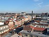
Federal Barn Federal Barn February 8, 1980 (#80003469 ) Off Pennsylvania Route 252 40°04′38″N 75°27′02″W / 40.077222°N 75.450556°W / 40.077222; -75.450556 (Federal Barn ) Tredyffrin Township
31
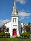
First Presbyterian Church of West Chester First Presbyterian Church of West Chester November 27, 1972 (#72001111 ) 130 West Miner Street 39°57′27″N 75°36′21″W / 39.957394°N 75.605863°W / 39.957394; -75.605863 (First Presbyterian Church of West Chester ) West Chester The first commission of Thomas Ustick Walter (1832)
32
Fox Chase Inn Fox Chase Inn September 6, 1984 (#84003253 ) 613 Swedesford Road 40°02′18″N 75°36′53″W / 40.038333°N 75.614722°W / 40.038333; -75.614722 (Fox Chase Inn ) West Whiteland Township
33
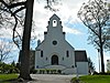
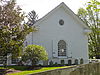
Garrett Farmstead Garrett Farmstead February 27, 2003 (#03000076 ) 808 and 816 Warren Avenue 39°59′41″N 75°29′19″W / 39.994722°N 75.488611°W / 39.994722; -75.488611 (Garrett Farmstead ) Willistown Township
34
Gay Street School Gay Street School November 1, 1983 (#83004202 ) Gay and Morgan Streets 40°07′49″N 75°31′04″W / 40.130278°N 75.517778°W / 40.130278; -75.517778 (Gay Street School ) Phoenixville
35
Goodwin Acres Goodwin Acres June 27, 1980 (#80003471 ) 600 Reservoir Road 39°58′55″N 75°33′16″W / 39.981944°N 75.554444°W / 39.981944; -75.554444 (Goodwin Acres ) East Goshen Township
36
Goshenville Historic District Goshenville Historic District November 8, 2000 (#00001347 ) Mainly along North Chester Road near its junction with Paoli Pike 39°59′43″N 75°32′35″W / 39.995278°N 75.543056°W / 39.995278; -75.543056 (Goshenville Historic District ) East Goshen Township
37
Great Valley Mill Great Valley Mill September 1, 1983 (#83002224 ) 72 North Valley Road 40°03′58″N 75°29′25″W / 40.066111°N 75.490278°W / 40.066111; -75.490278 (Great Valley Mill ) Tredyffrin Township
38
Greenwood Farm Greenwood Farm October 24, 1996 (#96001196 ) 888 West Valley Drive near Wayne 40°04′03″N 75°25′26″W / 40.0675°N 75.423889°W / 40.0675; -75.423889 (Greenwood Farm ) Tredyffrin Township
39
Greenwood School Greenwood School November 10, 1983 (#83004208 ) 700 King Road 40°00′50″N 75°35′58″W / 40.013889°N 75.599583°W / 40.013889; -75.599583 (Greenwood School ) West Whiteland Township
40
Grove Historic District Grove Historic District August 2, 1984 (#84003264 ) South Whitford Road near Downingtown 40°00′16″N 75°38′03″W / 40.004444°N 75.634167°W / 40.004444; -75.634167 (Grove Historic District ) West Whiteland Township
41
David Havard House David Havard House October 26, 1972 (#72001107 ) South of Valley Forge, off Interstate 76 40°04′24″N 75°27′47″W / 40.073333°N 75.463056°W / 40.073333; -75.463056 (David Havard House ) Tredyffrin Township
42
George Hoffman House George Hoffman House April 2, 1984 (#84003272 ) 1311 Grove Road 39°59′42″N 75°37′57″W / 39.995°N 75.6325°W / 39.995; -75.6325 (George Hoffman House ) West Whiteland Township
43
Ivy Cottage Ivy Cottage November 9, 2018 (#84003961 ) 225 W. Lincoln Hwy. 40°01′38″N 75°38′01″W / 40.0271°N 75.6337°W / 40.0271; -75.6337 (Ivy Cottage ) West Whiteland Township
44
Benjamin Jacobs House Benjamin Jacobs House August 2, 1984 (#84003274 ) 325 North Ship Road 40°02′23″N 75°37′06″W / 40.039722°N 75.618333°W / 40.039722; -75.618333 (Benjamin Jacobs House ) West Whiteland Township
45
Francis W. Kennedy House Francis W. Kennedy House August 2, 1984 (#84003277 ) 4717 Highland Avenue 40°00′20″N 75°39′18″W / 40.005556°N 75.655°W / 40.005556; -75.655 (Francis W. Kennedy House ) West Whiteland Township
46
Kinbawn Kinbawn September 6, 1984 (#84003280 ) 405 Highland Avenue 40°00′11″N 75°39′09″W / 40.003056°N 75.6525°W / 40.003056; -75.6525 (Kinbawn ) West Whiteland Township
47
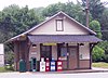
Kirkland Station Kirkland Station November 10, 1983 (#83004209 ) 1370 Kirkland Avenue 40°00′38″N 75°36′06″W / 40.010556°N 75.601528°W / 40.010556; -75.601528 (Kirkland Station ) West Whiteland Township
48
Lafayette's Quarters Lafayette's Quarters June 20, 1974 (#74001774 ) Southeast of Valley Forge on Wilson Road 40°04′18″N 75°27′33″W / 40.071667°N 75.459167°W / 40.071667; -75.459167 (Lafayette's Quarters ) Tredyffrin Township
49
Lapp Log House Lapp Log House January 23, 1980 (#80003455 ) South of Chester Springs at Conestoga and Yellow Springs Roads 40°03′18″N 75°35′38″W / 40.055°N 75.593889°W / 40.055; -75.593889 (Lapp Log House ) East Whiteland Township
50
Evan Lewis House Evan Lewis House August 2, 1984 (#84003286 ) 117 North Ship Road near Exton 40°01′57″N 75°36′42″W / 40.0325°N 75.611667°W / 40.0325; -75.611667 (Evan Lewis House ) West Whiteland Township
51
Lochiel Farm Lochiel Farm September 6, 1984 (#84003289 ) 111A North Ship Road 40°01′55″N 75°36′31″W / 40.031944°N 75.608611°W / 40.031944; -75.608611 (Lochiel Farm ) West Whiteland Township
52
Martin-Little House Martin-Little House July 2, 1973 (#73001611 ) South of Phoenixville off Pennsylvania Route 113 on Church Road 40°05′03″N 75°33′51″W / 40.084167°N 75.564167°W / 40.084167; -75.564167 (Martin-Little House ) Charlestown Township
53
Daniel Meredith House Daniel Meredith House August 2, 1984 (#84003291 ) 1358 Glen Echo Road 40°00′15″N 75°36′39″W / 40.004167°N 75.610833°W / 40.004167; -75.610833 (Daniel Meredith House ) West Whiteland Township
54
Middle Pickering Rural Historic District Middle Pickering Rural Historic District September 6, 1991 (#91001125 ) Pikeland, Yellow Springs, Merlin, Church, and Pickering Roads 40°05′40″N 75°34′38″W / 40.094444°N 75.577222°W / 40.094444; -75.577222 (Middle Pickering Rural Historic District ) Charlestown Township Extends into East and West Pikeland Townships in northern Chester County
55
Moore Hall Moore Hall November 19, 1974 (#74001771 ) East of Phoenixville on Valley Forge Road 40°07′22″N 75°29′01″W / 40.122778°N 75.483611°W / 40.122778; -75.483611 (Moore Hall ) Schuylkill Township
56
Mount Zion A.M.E. Church Mount Zion A.M.E. Church January 27, 2015 (#14001220 ) 380 N. Fairfield Rd. 40°03′23″N 75°26′03″W / 40.0563°N 75.4342°W / 40.0563; -75.4342 (Mount Zion A.M.E. Church ) Tredyffrin Township
57
New Century Clubhouse New Century Clubhouse February 24, 1983 (#83002225 ) 501 South High Street 39°57′20″N 75°35′58″W / 39.955445°N 75.599501°W / 39.955445; -75.599501 (New Century Clubhouse ) West Chester
58
Newlin Miller's House Newlin Miller's House September 6, 1984 (#84003293 ) 1240 Samuel Road 39°59′40″N 75°38′12″W / 39.994444°N 75.636667°W / 39.994444; -75.636667 (Newlin Miller's House ) West Whiteland Township
59
Oaklands Oaklands September 6, 1984 (#84003295 ) 349 West Lincoln Highway 40°01′31″N 75°38′37″W / 40.025278°N 75.643611°W / 40.025278; -75.643611 (Oaklands ) West Whiteland Township
60
Okehocking Historic District Okehocking Historic District August 2, 1993 (#93000719 ) Roughly bounded by West Chester Pike, Plumsock Road, Goshen Road, and Garrett Mill Road, near Media 39°58′35″N 75°29′19″W / 39.976389°N 75.488611°W / 39.976389; -75.488611 (Okehocking Historic District ) Willistown Township
61
Martha and Maurice Ostheimer Estate Martha and Maurice Ostheimer Estate February 16, 1996 (#96000099 ) 620 West Lincoln Highway near Exton 40°01′13″N 75°39′45″W / 40.020278°N 75.6625°W / 40.020278; -75.6625 (Martha and Maurice Ostheimer Estate ) West Whiteland Township
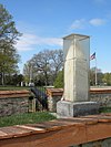
62
Paoli Battlefield Site and Parade Grounds Paoli Battlefield Site and Parade Grounds October 23, 1997 (#97001248 ) Roughly bounded by Warren, and Monument Avenues, and Sugartown Road 40°01′42″N 75°31′10″W / 40.028333°N 75.519444°W / 40.028333; -75.519444 (Paoli Battlefield Site and Parade Grounds ) Malvern
63
Benjamin Pennypacker House Benjamin Pennypacker House August 2, 1984 (#84003298 ) 800 East Swedesford Road 40°02′27″N 75°36′14″W / 40.040833°N 75.603889°W / 40.040833; -75.603889 (Benjamin Pennypacker House ) West Whiteland Township
64
Matthias Pennypacker Farm Matthias Pennypacker Farm December 27, 1977 (#77001154 ) South of Phoenixville on White Horse Road 40°06′38″N 75°30′27″W / 40.110556°N 75.5075°W / 40.110556; -75.5075 (Matthias Pennypacker Farm ) Schuylkill Township
65
Phoenixville Historic District Phoenixville Historic District March 17, 1987 (#87000378 ) Roughly bounded by Penn Street, railroad tracks, 4th Avenue, and Wheatland StreetApril 18, 2012 , refnum 12000220): High, Dayton, Railroad, Vanderslice, Bridge, & N. Main Sts., Wheatland & French Cr. 40°07′57″N 75°31′02″W / 40.1325°N 75.517222°W / 40.1325; -75.517222 (Phoenixville Historic District ) Phoenixville
66
Pickwick Pickwick July 28, 1988 (#88001163 ) Northern side of Swedesford Road 40°02′28″N 75°35′40″W / 40.041111°N 75.594444°W / 40.041111; -75.594444 (Pickwick ) West Whiteland Township
67
Joseph Price House Joseph Price House September 6, 1984 (#84003299 ) 401 Clover Mill Road 40°01′04″N 75°38′27″W / 40.017778°N 75.640833°W / 40.017778; -75.640833 (Joseph Price House ) West Whiteland Township
68
Joseph Rothrock House Joseph Rothrock House September 6, 1984 (#84003211 ) 428 North Church Street 39°57′49″N 75°36′34″W / 39.963611°N 75.609444°W / 39.963611; -75.609444 (Joseph Rothrock House ) West Chester
69
Roughwood Roughwood November 23, 1984 (#84000318 ) 107 Old Lancaster Road in Devon 40°02′58″N 75°25′18″W / 40.049444°N 75.421667°W / 40.049444; -75.421667 (Roughwood ) Easttown Township
70
Benjamin Rush House Benjamin Rush House August 2, 1984 (#84003300 ) Boot Road 40°00′32″N 75°36′17″W / 40.008889°N 75.604722°W / 40.008889; -75.604722 (Benjamin Rush House ) West Whiteland Township
71
St. Paul's Church St. Paul's Church September 6, 1984 (#84003304 ) 901 East Lincoln Highway near Exton 40°01′59″N 75°35′26″W / 40.033056°N 75.590556°W / 40.033056; -75.590556 (St. Paul's Church ) West Whiteland Township
72
St. Peter's Church in the Great Valley St. Peter's Church in the Great Valley November 21, 1977 (#77001155 ) South of Phoenixville off Pennsylvania Route 423 40°04′05″N 75°31′33″W / 40.068056°N 75.525833°W / 40.068056; -75.525833 (St. Peter's Church in the Great Valley ) East Whiteland Township
73
Schuylkill Navigation Canal, Oakes Reach Section Schuylkill Navigation Canal, Oakes Reach Section May 6, 1988 (#88000462 ) Northern and eastern bank of Schuylkill River from Pennsylvania Route 113 to Lock 61 40°08′40″N 75°30′31″W / 40.144444°N 75.508611°W / 40.144444; -75.508611 (Schuylkill Navigation Canal, Oakes Reach Section ) Phoenixville Extends into Montgomery County
74
Sharples Homestead Sharples Homestead September 19, 1985 (#85002412 ) 22 Dean Street 39°57′22″N 75°36′06″W / 39.956127°N 75.601775°W / 39.956127; -75.601775 (Sharples Homestead ) West Chester
75
Sharples Separator Works Sharples Separator Works June 28, 1984 (#84003214 ) North Franklin and Evans Streets 39°57′52″N 75°36′05″W / 39.964458°N 75.601305°W / 39.964458; -75.601305 (Sharples Separator Works ) West Chester
76
Ship Inn Ship Inn August 2, 1984 (#84003301 ) 100 North Ship Road near Exton 40°01′47″N 75°36′39″W / 40.029722°N 75.610833°W / 40.029722; -75.610833 (Ship Inn ) West Whiteland Township
77
Sleepy Hollow Hall Sleepy Hollow Hall August 2, 1984 (#84003302 ) 109 East Lincoln Highway 40°01′43″N 75°37′38″W / 40.028611°N 75.627222°W / 40.028611; -75.627222 (Sleepy Hollow Hall ) West Whiteland Township
78
Solitude Farm Solitude Farm August 2, 1984 (#84003303 ) Church Farm Road 40°02′53″N 75°36′11″W / 40.048056°N 75.603056°W / 40.048056; -75.603056 (Solitude Farm ) West Whiteland Township
79
Spring Mill Complex Spring Mill Complex December 14, 1978 (#78002370 ) Southwest of Devault at the junction of Moores Road and Pennsylvania Route 401 40°03′09″N 75°33′53″W / 40.0525°N 75.564722°W / 40.0525; -75.564722 (Spring Mill Complex ) East Whiteland Township
80
Maj. Gen. Lord Stirling Quarters Maj. Gen. Lord Stirling Quarters February 15, 1974 (#74000283 ) South of Valley Forge on Yellow Springs Road 40°05′04″N 75°27′46″W / 40.084444°N 75.462778°W / 40.084444; -75.462778 (Maj. Gen. Lord Stirling Quarters ) Tredyffrin Township
81
Oskar G. Stonorov House Oskar G. Stonorov House December 6, 1975 (#75001631 ) Southwest of Phoenixville on Pickering Road 40°06′01″N 75°34′21″W / 40.100278°N 75.5725°W / 40.100278; -75.5725 (Oskar G. Stonorov House ) Charlestown Township
82
Strafford Railroad Station Strafford Railroad Station July 26, 1984 (#84003226 ) Old Eagle School Road at Strafford 40°02′58″N 75°24′16″W / 40.049444°N 75.404444°W / 40.049444; -75.404444 (Strafford Railroad Station ) Tredyffrin Township
83
Sugartown Historic District Sugartown Historic District September 7, 1984 (#84003230 ) Sugartown, Boot, Spring, Dutton Mill, and Providence Roads, near Malvern 39°59′57″N 75°30′30″W / 39.999167°N 75.508333°W / 39.999167; -75.508333 (Sugartown Historic District ) Willistown Township
84
Thomas Marble Quarry Houses Thomas Marble Quarry Houses August 2, 1984 (#84003306 ) Quarry Lane 40°01′12″N 75°38′19″W / 40.02°N 75.638611°W / 40.02; -75.638611 (Thomas Marble Quarry Houses ) West Whiteland Township
85
Thomas Mill and Miller's House Thomas Mill and Miller's House May 19, 2004 (#04000468 ) 130 West Lincoln Highway 40°01′44″N 75°38′00″W / 40.028889°N 75.633333°W / 40.028889; -75.633333 (Thomas Mill and Miller's House ) West Whiteland Township
86
Charles Thomas House Charles Thomas House September 6, 1984 (#84003305 ) 225 North Whitford Road 40°01′51″N 75°38′56″W / 40.030833°N 75.648889°W / 40.030833; -75.648889 (Charles Thomas House ) West Whiteland Township
87
Valley Forge National Historical Park Valley Forge National Historical Park October 15, 1966 (#66000657 ) Valley Forge State Park 40°05′48″N 75°26′55″W / 40.096667°N 75.448611°W / 40.096667; -75.448611 (Valley Forge National Historical Park ) Tredyffrin Township Extends into Upper Merion Township in Montgomery County
88
Gen. Frederick Von Steuben Headquarters Gen. Frederick Von Steuben Headquarters November 28, 1972 (#72001108 ) Pennsylvania Route 23 40°05′56″N 75°28′13″W / 40.098889°N 75.470278°W / 40.098889; -75.470278 (Gen. Frederick Von Steuben Headquarters ) Schuylkill Township
89
Joseph Walker House Joseph Walker House June 1, 1987 (#86003566 ) 274 Anthony Wayne Drive 40°04′36″N 75°26′00″W / 40.076667°N 75.433333°W / 40.076667; -75.433333 (Joseph Walker House ) Tredyffrin Township
90
Warner Theater Warner Theater November 29, 1979 (#79002207 ) 120 North High Street 39°57′40″N 75°36′21″W / 39.961008°N 75.605894°W / 39.961008; -75.605894 (Warner Theater ) West Chester
91
Waterloo Mills Historic District Waterloo Mills Historic District July 21, 1995 (#95000889 ) 815, 840, 855, and 860 Waterloo Road, near Waterloo Mills 40°01′25″N 75°25′04″W / 40.023611°N 75.417778°W / 40.023611; -75.417778 (Waterloo Mills Historic District ) Easttown Township
92
Waynesborough Waynesborough March 7, 1973 (#73001603 ) 2049 Waynesborough Road near Paoli 40°01′55″N 75°28′26″W / 40.031944°N 75.473889°W / 40.031944; -75.473889 (Waynesborough ) Easttown Township
93
Wee Grimmet Wee Grimmet August 2, 1984 (#84003312 ) 624 West Lincoln Highway 40°01′15″N 75°39′42″W / 40.020833°N 75.661667°W / 40.020833; -75.661667 (Wee Grimmet ) West Whiteland Township
94
West Chester Boarding School for Boys West Chester Boarding School for Boys January 4, 1990 (#89002257 ) 200 East Biddle Street 39°57′53″N 75°36′15″W / 39.964593°N 75.604107°W / 39.964593; -75.604107 (West Chester Boarding School for Boys ) West Chester
95
West Chester Downtown Historic District West Chester Downtown Historic District July 2, 1985 (#85001447 ) Roughly bounded by Biddle, Matlack, Barnard and New Streets 39°57′37″N 75°36′20″W / 39.960278°N 75.605556°W / 39.960278; -75.605556 (West Chester Downtown Historic District ) West Chester
96
West Chester State College Quadrangle Historic District West Chester State College Quadrangle Historic District October 8, 1981 (#81000539 ) Bounded by South High and South Church Streets, College and Rosedale Avenues 39°57′08″N 75°35′55″W / 39.952222°N 75.598611°W / 39.952222; -75.598611 (West Chester State College Quadrangle Historic District ) West Chester Part of West Chester University , includes the Old Library and Philips Memorial Building
97
West Whiteland Inn West Whiteland Inn August 2, 1984 (#84003313 ) 609 West Lincoln Highway near Exton 40°01′21″N 75°39′42″W / 40.0225°N 75.661667°W / 40.0225; -75.661667 (West Whiteland Inn ) West Whiteland Township
98
Wetherby-Hampton-Snyder-Wilson-Erdman Log House Wetherby-Hampton-Snyder-Wilson-Erdman Log House April 2, 1973 (#73001613 ) 251 Irish Road 40°03′00″N 75°27′25″W / 40.05°N 75.456944°W / 40.05; -75.456944 (Wetherby-Hampton-Snyder-Wilson-Erdman Log House ) Tredyffrin Township
99
White Horse Farm White Horse Farm July 29, 1987 (#87001206 ) 54 South Whitehorse Road 40°07′06″N 75°30′19″W / 40.118333°N 75.505278°W / 40.118333; -75.505278 (White Horse Farm ) Schuylkill Township
100
White Horse Historic District White Horse Historic District February 2, 2001 (#01000058 ) Junction of Goshen and Providence Roads 39°59′26″N 75°28′09″W / 39.990556°N 75.469167°W / 39.990556; -75.469167 (White Horse Historic District ) Willistown Township
101
White Horse Tavern White Horse Tavern December 29, 1978 (#78002373 ) Northwest of Malvern at 480 Swedesford Road 40°02′30″N 75°34′41″W / 40.041667°N 75.578056°W / 40.041667; -75.578056 (White Horse Tavern ) East Whiteland Township
102
Hannah White Log House Hannah White Log House August 2, 1984 (#84003315 ) 545 West Boot Road 40°00′15″N 75°38′15″W / 40.004167°N 75.6375°W / 40.004167; -75.6375 (Hannah White Log House ) West Whiteland Township
103
Whitford Garne Whitford Garne September 6, 1984 (#84003317 ) 201 West Boot Road 40°00′46″N 75°37′34″W / 40.012778°N 75.626111°W / 40.012778; -75.626111 (Whitford Garne ) West Whiteland Township
104
Whitford Hall Whitford Hall September 6, 1984 (#84003319 ) 145 West Lincoln Highway 40°01′39″N 75°37′58″W / 40.0275°N 75.632778°W / 40.0275; -75.632778 (Whitford Hall ) West Whiteland Township
105
Whitford Station House Whitford Station House August 2, 1984 (#84003324 ) 405 South Whitford Road 40°00′51″N 75°38′15″W / 40.014167°N 75.6375°W / 40.014167; -75.6375 (Whitford Station House ) West Whiteland Township
106
Williams Deluxe Cabins Williams Deluxe Cabins July 28, 1988 (#88001165 ) Lincoln Highway 40°01′59″N 75°37′01″W / 40.033056°N 75.616944°W / 40.033056; -75.616944 (Williams Deluxe Cabins ) West Whiteland Township
107
Ellis Williams House Ellis Williams House August 11, 2004 (#04000835 ) 1711 East Boot Road 39°59′58″N 75°31′45″W / 39.999444°N 75.529167°W / 39.999444; -75.529167 (Ellis Williams House ) East Goshen Township
108
John Williams Farm John Williams Farm December 15, 1978 (#78002377 ) South of Phoenixville on Union Hill Road 40°05′27″N 75°32′19″W / 40.090833°N 75.538611°W / 40.090833; -75.538611 (John Williams Farm ) Charlestown Township
109
Jacob Wisner House Jacob Wisner House August 6, 1979 (#79002201 ) Northwest of Malvern on Yellow Springs Road 40°04′23″N 75°34′29″W / 40.073056°N 75.574722°W / 40.073056; -75.574722 (Jacob Wisner House ) Charlestown Township
110
Woodland Station Woodland Station September 6, 1984 (#84003326 ) 408 King Road 40°01′13″N 75°34′55″W / 40.020278°N 75.581944°W / 40.020278; -75.581944 (Woodland Station ) West Whiteland Township
111
Woodledge Woodledge July 28, 1988 (#88001161 ) 525 West Lincoln Highway 40°01′26″N 75°39′26″W / 40.023889°N 75.657222°W / 40.023889; -75.657222 (Woodledge ) West Whiteland Township
112
Zook House Zook House July 27, 2000 (#00000844 ) 100 Exton Square 40°01′43″N 75°37′34″W / 40.028611°N 75.626111°W / 40.028611; -75.626111 (Zook House ) West Whiteland Township First listed on January 1, 1976. In 1999 the house was moved 300 feet and automatically delisted. In 2000 it was relisted.
113
Jacob Zook House Jacob Zook House February 24, 1995 (#95000127 ) 290 East Lincoln Highway near Exton 40°01′44″N 75°37′27″W / 40.028889°N 75.624167°W / 40.028889; -75.624167 (Jacob Zook House ) West Whiteland Township