415:
99:
64:
43:
88:
31:
180:
are among the hottest places in the Sahara. Annual average rainfall is well above 100 mm (3.9 in) in the northernmost part but the center and the southern part receive much less than 50 mm (2.0 in).
212:
In the north, the grass of the steppe slowly becomes rarer while the species change until it makes way for the reg. The erg, the sandy desert, covers only a fifth of the Sahara. The
201:
in the far south. The
Algerian Desert is characterized by low rainfall, recording less than 100 mm per year. However, it rarely snows and floods, sometimes reviving the
146:. The desert covers more than 90% of Algeria's total area. In 2018, it was home to a population of 3,600,000 inhabitants, or 10.5% of the Algerian population.
456:
232:
valley cut into a plateau. The northern
Algerian Desert contains several oases, as opposed to the southern Algerian Desert, that is dominated by the
396:
367:
209:
which extends under a large part of the
Algerian Desert, a remnant of the steppe climate that the region experienced 10,000 years ago.
485:
449:
269:
480:
442:
120:
225:
158:
206:
221:
165:
213:
92:
205:(river valleys) that have been dry since prehistoric times. The subsoil is full of water in the
154:
392:
363:
312:
297:[Demography and urbanization in the Algerian Sahara at the dawn of the 21st century].
426:
302:
233:
475:
194:
111:
153:
as a stony desert, gradually changing into a sand dune desert inland. The plateau of the
414:
190:
173:
79:
469:
150:
135:
98:
241:
30:
42:
316:
294:
217:
249:
245:
229:
177:
295:"Démographie et urbanisation au Sahara algérien à l'aube du XXIe siècle"
422:
220:, a succession of oases that stretches along the underground wadi. The
169:
139:
69:
307:
330:
237:
198:
162:
143:
131:
87:
299:
The EMAM Notebooks. Studies on the Arab World and the
Mediterranean
189:
The Sahara covers over 90% of
Algerian territory. It is crossed by
97:
86:
236:
massif at an altitude of more than 3,000 meters. Vast monotonous
202:
157:
is located in the southeast, and its outstanding collection of
430:
362:] (in French). De Boeck Supérieur. pp. 41–42.
391:] (in French). Editions Complexe. pp. 20–21.
252:
connect the large geographical areas of the Sahara.
125:
75:
57:
52:
21:
228:to the west. Between these two large ergs is the
331:"Tassili n'Ajjer - UNESCO World Heritage Centre"
293:Kouzmine, Yaël; Fontaine, Jacques (2018-04-18).
450:
8:
457:
443:
306:
261:
240:(hard rocky desert plateaus) like the
18:
216:(Great Eastern Sand Sea) borders the
197:(stony terrain), as well as volcanic
7:
411:
409:
349:
347:
115:
429:. You can help Knowledge (XXG) by
270:"Earth from Space: Algerian sands"
168:in 1982. Cities and towns such as
14:
413:
62:
41:
29:
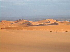
47:Map of the Algerian arid desert
149:Its expansion starts from the
1:
385:L'Algérie et ses populations
383:Durand, Jean-Pierre (1982).
16:North-central African region
389:Algeria and its populations
142:, constituting part of the
126:
502:
408:
354:Cherbi, Massensen (2015).
40:
28:
127:al-Saḥrā' al-Jazā'iriyah
486:Algeria geography stubs
425:location article is a
103:
95:
101:
90:
35:Sand dunes of Algeria
226:Grand Erg Occidental
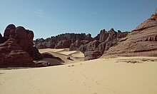
161:saw it added to the
159:prehistoric rock art
176:, and particularly
166:World Heritage List
134:located in central
481:Deserts of Algeria
301:(in French) (30).
214:Grand Erg Oriental
104:
102:Tamanrasset desert
96:
93:El Bayadh Province
438:
437:
398:978-2-87027-095-0
369:978-2-8041-9106-1
308:10.4000/emam.1426
124:
116:الصحراء الجزائرية
85:
84:
24:الصحراء الجزائرية
493:
459:
452:
445:
417:
410:
403:
402:
380:
374:
373:
351:
342:
341:
339:
338:
333:. Whc.unesco.org
327:
321:
320:
310:
290:
284:
283:
281:
280:
266:
242:Tademaït plateau
129:
119:
117:
68:
66:
65:
45:
33:
19:
501:
500:
496:
495:
494:
492:
491:
490:
466:
465:
464:
463:
407:
406:
399:
382:
381:
377:
370:
353:
352:
345:
336:
334:
329:
328:
324:
292:
291:
287:
278:
276:
268:
267:
263:
258:
187:
155:Tassili n'Ajjer
108:Algerian Desert
63:
61:
48:
36:
23:
22:Algerian Desert
17:
12:
11:
5:
499:
497:
489:
488:
483:
478:
468:
467:
462:
461:
454:
447:
439:
436:
435:
418:
405:
404:
397:
375:
368:
343:
322:
285:
260:
259:
257:
254:
207:Albian Aquifer
193:(sand dunes),
186:
183:
83:
82:
77:
73:
72:
59:
55:
54:
50:
49:
46:
38:
37:
34:
26:
25:
15:
13:
10:
9:
6:
4:
3:
2:
498:
487:
484:
482:
479:
477:
474:
473:
471:
460:
455:
453:
448:
446:
441:
440:
434:
432:
428:
424:
419:
416:
412:
400:
394:
390:
386:
379:
376:
371:
365:
361:
357:
350:
348:
344:
332:
326:
323:
318:
314:
309:
304:
300:
296:
289:
286:
275:
271:
265:
262:
255:
253:
251:
247:
243:
239:
235:
231:
227:
223:
222:Saoura valley
219:
215:
210:
208:
204:
200:
196:
192:
184:
182:
179:
175:
171:
167:
164:
160:
156:
152:
151:Saharan Atlas
147:
145:
141:
137:
133:
128:
122:
113:
109:
100:
94:
89:
81:
78:
74:
71:
60:
56:
51:
44:
39:
32:
27:
20:
431:expanding it
420:
388:
384:
378:
359:
355:
335:. Retrieved
325:
298:
288:
277:. Retrieved
273:
264:
211:
188:
148:
136:North Africa
107:
105:
76:Climate type
274:www.esa.int
224:limits the
91:El Gour in
80:Arid desert
470:Categories
337:2013-03-18
279:2023-08-31
256:References
317:1969-248X
218:Wadi Righ
185:Geography
121:romanized
53:Geography
250:In Salah
246:El Goléa
244:between
178:In Salah
423:Algeria
360:Algeria
356:Algérie
238:hamadas
199:massifs
170:Ouargla
140:Algeria
138:within
130:) is a
123::
70:Algeria
58:Country
476:Sahara
395:
366:
315:
234:Hoggar
163:UNESCO
144:Sahara
132:desert
112:Arabic
67:
421:This
387:[
358:[
230:M'zab
203:wadis
174:Adrar
427:stub
393:ISBN
364:ISBN
313:ISSN
248:and
195:regs
191:ergs
106:The
303:doi
472::
346:^
311:.
272:.
172:,
118:,
114::
458:e
451:t
444:v
433:.
401:.
372:.
340:.
319:.
305::
282:.
110:(
Text is available under the Creative Commons Attribution-ShareAlike License. Additional terms may apply.