513:
1392:
66:
921:
99:
45:
106:
73:
236:
with
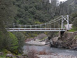
Briceburg Road. The bridge is a 160-foot (49 m) suspension bridge built by the US Forest Service in 1937 and constructed by 30 Civilian Conservation Corps enrollees. Forest Service Engineer J.W. Nute was in charge of construction. The community name honors William M. Brice, who built a
240:
After a 2019 fire, Pacific Gas & Electric decided to create a self-reliant power system rather than rebuilding poles and wires to serve the remote community. The stand-alone power grid includes solar panels, batteries and a backup generator.
1457:
1356:
371:
1462:
328:
1433:
1452:
727:
1361:
1246:
487:
976:
364:
134:
422:
1426:
652:
1229:
65:
720:
642:
612:
357:
1017:
98:
1419:
288:
44:
1366:
713:
349:
1195:
931:
744:
1351:
1346:
757:
1399:
1169:
497:
381:
217:
189:
1261:
1251:
1040:
1010:
622:
544:
472:
437:
233:
1289:
1256:
1234:
1154:
685:
672:
657:
502:
1239:
1068:
870:
851:
569:
462:
442:
432:
262:
1391:
1200:
1190:
637:
414:
1328:
1293:
1061:
910:
895:
890:
736:
647:
607:
579:
574:
559:
1284:
1144:
1075:
617:
597:
452:
447:
232:, at an elevation of 1138 feet (347 m). It is accessed via a bridge over the Merced River that connects
1323:
1318:
1308:
1303:
1031:
772:
692:
482:
477:
467:
427:
403:
229:
1279:
920:
667:
632:
627:
564:
554:
534:
524:
457:
213:
35:
313:
1298:
1126:
1047:
662:
549:
492:
1371:
1174:
1164:
905:
833:
602:
284:
1403:
1024:
797:
782:
1116:
1111:
941:
860:
807:
752:
1054:
1149:
1101:
981:
961:
951:
900:
822:
777:
1446:
1210:
971:
956:
840:
767:
169:
281:
California's
Geographic Names: A Gazetteer of Historic and Modern Names of the State
1159:
1121:
991:
986:
762:
225:
50:
263:
U.S. Geological Survey
Geographic Names Information System: Briceburg, California
1106:
885:
880:
865:
792:
396:
966:
946:
875:
827:
787:
221:
179:
149:
136:
1096:
846:
817:
314:"Briceburg Fire fully contained at 5,563 acres, according to fire officials"
228:
near the confluence with Bear Creek, 5 miles (8 km) north-northwest of
1205:
705:
709:
353:
1357:
National
Register of Historic Places in Yosemite National Park
919:
511:
329:"California tests off-the-grid solutions to power outages"
1458:
Unincorporated communities in
Mariposa County, California
1407:
283:. Clovis, Calif.: Word Dancer Press. p. 749-750.
21:
Unincorporated community in
California, United States
16:
Unincorporated community in
California, United States
1337:
1270:
1219:
1183:
1135:
1089:
1000:
930:
806:
743:
588:
523:
413:
195:
185:
175:
165:
26:
1427:
721:
365:
8:
1463:Mariposa County, California geography stubs
512:
1434:
1420:
803:
728:
714:
706:
372:
358:
350:
23:
1453:Unincorporated communities in California
250:
194:
164:
129:
57:
41:
258:
256:
254:
274:
272:
270:
184:
174:
7:
1388:
1386:
1062:Steck-Salathé Route (Sentinel Rock)
1406:. You can help Knowledge (XXG) by
1285:El Portal & Arch Rock Entrance
380:Municipalities and communities of
14:
105:
72:
1390:
778:Mariposa Grove of Giant Sequoias
104:
97:
71:
64:
43:
327:Nguyen, Daisy (June 30, 2021).
237:store at the location in 1926.
1196:1996 Yosemite Valley landslide
1:
121:Show map of the United States
118:Briceburg (the United States)
1352:Geology of the Yosemite area
1347:History of the Yosemite area
1400:Mariposa County, California
1145:Yosemite Lodge at the Falls
383:Mariposa County, California
1479:
1385:
199:1,138 ft (347 m)
1055:Salathé Wall (El Capitan)
1018:Half Dome, Northwest Face
1011:Fairview Dome, North Face
917:
681:
509:
394:
279:Durham, David L. (1998).
130:
58:
42:
33:
214:unincorporated community
36:Unincorporated community
1201:1997 Merced River flood
1191:1938 Yosemite TWA crash
224:. It is located on the
1402:–related article is a
1211:2022 Washburn Wildfire
924:
911:Yosemite Valley Chapel
891:Little Yosemite Valley
737:Yosemite National Park
517:
150:37.60500°N 119.96694°W
88:Show map of California
85:Location in California
1076:The Nose (El Capitan)
923:
515:
1032:Lost Arrow Spire Tip
694:United States portal
155:37.60500; -119.96694
516:Mariposa County map
146: /
1362:List of waterfalls
1127:Ahwahnechee people
1048:Royal Arches Route
1041:Midnight Lightning
925:
901:Bracebridge Dinner
518:
1415:
1414:
1380:
1379:
1372:California Portal
1367:Yosemite Category
1206:2013 Rim Wildfire
1184:Natural disasters
1170:High Sierra Camps
1165:Housekeeping Camp
1102:Stephen T. Mather
1085:
1084:
906:Yosemite Firefall
703:
702:
687:California portal
203:
202:
1470:
1436:
1429:
1422:
1394:
1387:
1226:Nearby airports
1117:Buffalo Soldiers
1069:Separate Reality
1025:Lost Arrow Spire
804:
798:Chilnualna Falls
783:Tuolumne Meadows
758:Yosemite Village
730:
723:
716:
707:
695:
688:
514:
406:
399:
389:
384:
374:
367:
360:
351:
344:
343:
341:
339:
324:
318:
317:
310:
304:
303:Mariposa Gazette
301:
295:
294:
276:
265:
260:
161:
160:
158:
157:
156:
151:
147:
144:
143:
142:
139:
122:
108:
107:
101:
89:
75:
74:
68:
49:Bridge over the
47:
24:
1478:
1477:
1473:
1472:
1471:
1469:
1468:
1467:
1443:
1442:
1441:
1440:
1383:
1381:
1376:
1339:
1333:
1272:
1266:
1215:
1179:
1137:
1131:
1112:Shelton Johnson
1081:
1002:
996:
942:John Muir Trail
933:
926:
915:
861:Bridalveil Fall
810:
802:
753:Yosemite Valley
739:
734:
704:
699:
693:
686:
677:
590:
584:
526:
519:
507:
498:Yosemite Valley
409:
404:
397:
390:
387:
382:
378:
348:
347:
337:
335:
326:
325:
321:
312:
311:
307:
302:
298:
291:
278:
277:
268:
261:
252:
247:
218:Mariposa County
190:Mariposa County
154:
152:
148:
145:
140:
137:
135:
133:
132:
126:
125:
124:
123:
120:
119:
116:
115:
114:
113:
109:
92:
91:
90:
87:
86:
83:
82:
81:
80:
76:
54:
38:
29:
22:
17:
12:
11:
5:
1476:
1474:
1466:
1465:
1460:
1455:
1445:
1444:
1439:
1438:
1431:
1424:
1416:
1413:
1412:
1395:
1378:
1377:
1375:
1374:
1369:
1364:
1359:
1354:
1349:
1343:
1341:
1335:
1334:
1332:
1331:
1326:
1321:
1316:
1311:
1306:
1301:
1296:
1287:
1282:
1276:
1274:
1273:municipalities
1268:
1267:
1265:
1264:
1259:
1254:
1249:
1244:
1243:
1242:
1237:
1232:
1223:
1221:
1220:Transportation
1217:
1216:
1214:
1213:
1208:
1203:
1198:
1193:
1187:
1185:
1181:
1180:
1178:
1177:
1172:
1167:
1162:
1157:
1152:
1147:
1141:
1139:
1133:
1132:
1130:
1129:
1124:
1119:
1114:
1109:
1104:
1099:
1093:
1091:
1087:
1086:
1083:
1082:
1080:
1079:
1072:
1065:
1058:
1051:
1044:
1037:
1036:
1035:
1021:
1014:
1006:
1004:
998:
997:
995:
994:
989:
984:
982:Mariposa Grove
979:
974:
969:
964:
962:Ostrander Lake
959:
954:
952:Panorama Trail
949:
944:
938:
936:
928:
927:
918:
916:
914:
913:
908:
903:
898:
893:
888:
883:
878:
873:
868:
863:
858:
857:
856:
825:
823:Yosemite Falls
820:
814:
812:
801:
800:
795:
790:
785:
780:
775:
770:
765:
760:
755:
749:
747:
741:
740:
735:
733:
732:
725:
718:
710:
701:
700:
698:
697:
690:
682:
679:
678:
676:
675:
670:
665:
660:
655:
650:
645:
640:
635:
630:
625:
623:Horseshoe Bend
620:
615:
610:
605:
600:
594:
592:
586:
585:
583:
582:
577:
572:
567:
562:
557:
552:
547:
545:Clearing House
542:
537:
531:
529:
525:Unincorporated
521:
520:
510:
508:
506:
505:
500:
495:
490:
485:
480:
475:
473:Lake Don Pedro
470:
465:
460:
455:
450:
445:
440:
438:Catheys Valley
435:
430:
425:
419:
417:
411:
410:
395:
392:
391:
379:
377:
376:
369:
362:
354:
346:
345:
319:
305:
296:
289:
266:
249:
248:
246:
243:
201:
200:
197:
193:
192:
187:
183:
182:
177:
173:
172:
167:
163:
162:
128:
127:
117:
111:
110:
103:
102:
96:
95:
94:
93:
84:
78:
77:
70:
69:
63:
62:
61:
60:
59:
56:
55:
48:
40:
39:
34:
31:
30:
27:
20:
15:
13:
10:
9:
6:
4:
3:
2:
1475:
1464:
1461:
1459:
1456:
1454:
1451:
1450:
1448:
1437:
1432:
1430:
1425:
1423:
1418:
1417:
1411:
1409:
1405:
1401:
1396:
1393:
1389:
1384:
1373:
1370:
1368:
1365:
1363:
1360:
1358:
1355:
1353:
1350:
1348:
1345:
1344:
1342:
1336:
1330:
1327:
1325:
1322:
1320:
1317:
1315:
1312:
1310:
1307:
1305:
1302:
1300:
1297:
1295:
1291:
1290:Yosemite West
1288:
1286:
1283:
1281:
1278:
1277:
1275:
1269:
1263:
1260:
1258:
1255:
1253:
1250:
1248:
1245:
1241:
1238:
1236:
1233:
1231:
1228:
1227:
1225:
1224:
1222:
1218:
1212:
1209:
1207:
1204:
1202:
1199:
1197:
1194:
1192:
1189:
1188:
1186:
1182:
1176:
1173:
1171:
1168:
1166:
1163:
1161:
1158:
1156:
1153:
1151:
1148:
1146:
1143:
1142:
1140:
1134:
1128:
1125:
1123:
1120:
1118:
1115:
1113:
1110:
1108:
1105:
1103:
1100:
1098:
1095:
1094:
1092:
1088:
1078:
1077:
1073:
1071:
1070:
1066:
1064:
1063:
1059:
1057:
1056:
1052:
1050:
1049:
1045:
1043:
1042:
1038:
1034:
1033:
1029:
1028:
1027:
1026:
1022:
1020:
1019:
1015:
1013:
1012:
1008:
1007:
1005:
999:
993:
990:
988:
985:
983:
980:
978:
975:
973:
972:Sentinel Dome
970:
968:
965:
963:
960:
958:
957:McGurk Meadow
955:
953:
950:
948:
945:
943:
940:
939:
937:
935:
929:
922:
912:
909:
907:
904:
902:
899:
897:
896:LeConte Lodge
894:
892:
889:
887:
884:
882:
879:
877:
874:
872:
869:
867:
864:
862:
859:
855:
854:
849:
848:
843:
842:
841:The Dawn Wall
837:
836:
831:
830:
829:
826:
824:
821:
819:
816:
815:
813:
809:
805:
799:
796:
794:
791:
789:
786:
784:
781:
779:
776:
774:
771:
769:
768:Glacier Point
766:
764:
761:
759:
756:
754:
751:
750:
748:
746:
742:
738:
731:
726:
724:
719:
717:
712:
711:
708:
696:
691:
689:
684:
683:
680:
674:
673:Yosemite Mill
671:
669:
666:
664:
661:
659:
658:Ridleys Ferry
656:
654:
651:
649:
646:
644:
641:
639:
636:
634:
631:
629:
626:
624:
621:
619:
616:
614:
611:
609:
606:
604:
601:
599:
596:
595:
593:
587:
581:
578:
576:
573:
571:
568:
566:
563:
561:
558:
556:
553:
551:
548:
546:
543:
541:
538:
536:
533:
532:
530:
528:
522:
504:
503:Yosemite West
501:
499:
496:
494:
491:
489:
486:
484:
481:
479:
476:
474:
471:
469:
466:
464:
461:
459:
456:
454:
451:
449:
446:
444:
441:
439:
436:
434:
431:
429:
426:
424:
421:
420:
418:
416:
412:
408:
407:
400:
393:
388:United States
385:
375:
370:
368:
363:
361:
356:
355:
352:
334:
330:
323:
320:
315:
309:
306:
300:
297:
292:
290:1-884995-14-4
286:
282:
275:
273:
271:
267:
264:
259:
257:
255:
251:
244:
242:
238:
235:
231:
227:
223:
219:
215:
211:
207:
198:
191:
188:
181:
178:
171:
170:United States
168:
159:
131:Coordinates:
100:
67:
52:
46:
37:
32:
25:
19:
1408:expanding it
1397:
1382:
1313:
1160:Wawona Hotel
1150:The Ahwahnee
1122:Chief Tenaya
1074:
1067:
1060:
1053:
1046:
1039:
1030:
1023:
1016:
1009:
992:Lembert Dome
987:Wapama Falls
853:To the Limit
852:
845:
839:
834:
763:Hetch Hetchy
570:Indian Gulch
539:
463:Greeley Hill
443:Coulterville
433:Buck Meadows
402:
336:. Retrieved
332:
322:
308:
299:
280:
239:
226:Merced River
209:
205:
204:
53:at Briceburg
51:Merced River
18:
1340:information
1138:and camping
1107:Galen Clark
977:Alder Creek
886:Nevada Fall
881:Vernal Fall
871:Mirror Lake
866:Happy Isles
811:attractions
793:Wawona Tree
773:Badger Pass
745:Attractions
638:Mount Ophir
591:settlements
527:communities
488:Mt. Bullion
423:Bear Valley
398:County seat
234:Highway 140
208:(formerly,
153: /
141:119°58′01″W
1447:Categories
1338:Additional
1329:Lee Vining
1294:Chinquapin
1155:Camp Curry
967:Taft Point
947:Mist Trail
876:North Dome
835:El Capitan
828:El Capitan
788:Tioga Pass
653:Quartzburg
648:Notomidula
608:Chinquapin
580:Mormon Bar
575:Jerseydale
560:Hites Cove
245:References
222:California
210:Bear Creek
180:California
138:37°36′18″N
1314:Briceburg
1262:Route 120
1252:Route 140
1097:John Muir
847:Free Solo
818:Half Dome
618:Hokokwito
598:Agua Fria
540:Briceburg
453:Fish Camp
448:El Portal
206:Briceburg
196:Elevation
112:Briceburg
79:Briceburg
28:Briceburg
1324:Midpines
1319:Oakhurst
1309:Mariposa
1304:Bootjack
1257:Route 41
483:Midpines
478:Mariposa
468:Hornitos
428:Bootjack
405:Mariposa
230:Midpines
212:) is an
1280:Foresta
1136:Lodging
832:Films:
668:Wiskala
643:Newtown
633:Macheto
628:Kumaini
613:Dogtown
565:Incline
555:Foresta
535:Ben Hur
458:Foresta
338:July 2,
333:AP News
166:Country
1299:Wawona
1292:&
1271:Nearby
1175:Camp 4
1090:People
1003:climbs
934:trails
932:Hiking
808:Valley
663:Sakaya
589:Former
550:Darrah
493:Wawona
287:
186:County
1398:This
1247:YARTS
1001:Rock
603:Bagby
176:State
1404:stub
415:CDPs
340:2021
285:ISBN
1240:MMH
1235:MPI
1230:FAT
216:in
1449::
850:,
844:,
838:,
401::
386:,
331:.
269:^
253:^
220:,
1435:e
1428:t
1421:v
1410:.
729:e
722:t
715:v
373:e
366:t
359:v
342:.
316:.
293:.
Text is available under the Creative Commons Attribution-ShareAlike License. Additional terms may apply.