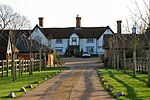
Name
Location
Type
Completed Date designated
Grid ref. Entry number Image
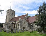
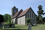
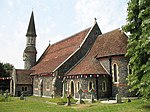
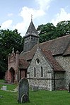
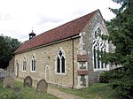
Church of St Mary
Church End, Albury , East Hertfordshire
Parish Church
13th century
22 February 1967 TL4355924734 51°54′10″N 0°05′07″E / 51.902658°N 0.085274°E / 51.902658; 0.085274 (Church of St Mary ) 1308146 Church of St Mary
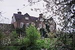
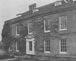
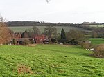
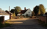
Ardeley Bury (700m to west of Church)
Ardeley Country House
Late 17th century
19 October 1951 TL3012127125 51°55′39″N 0°06′33″W / 51.927441°N 0.109028°W / 51.927441; -0.109028 (Ardeley Bury (700m to west of Church) ) 1101447 Upload Photo
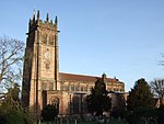
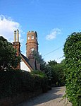
Cromer Windmill
Cromer , ArdeleyWindmill
c. 1222 22 February 1967 TL3045228642 51°56′28″N 0°06′13″W / 51.940995°N 0.103643°W / 51.940995; -0.103643 (Cromer Windmill ) 1101453 Cromer Windmill
Farmhouse at Chapel Farm including Former Congregational Chapel
Wood End , ArdeleyFarmhouse
Late 16th century
31 May 1984 TL3256325473 51°54′43″N 0°04′27″W / 51.912021°N 0.074171°W / 51.912021; -0.074171 (Farmhouse at Chapel Farm including Former Congregational Chapel ) 1101421 Farmhouse at Chapel Farm including Former Congregational Chapel
Farmhouse at Cromer Farm
Cromer, Ardeley
Farmhouse
Late 16th century or early 17th century
19 October 1951 TL2970228225 51°56′15″N 0°06′53″W / 51.937423°N 0.114704°W / 51.937423; -0.114704 (Farmhouse at Cromer Farm ) 1101451 Upload Photo
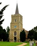
Parish Church of St Mary the Virgin
Aston Parish Church
c. 1230 24 November 1966 TL2716722614 51°53′15″N 0°09′13″W / 51.887587°N 0.153628°W / 51.887587; -0.153628 (Parish Church of St Mary the Virgin ) 1101433 Parish Church of St Mary the Virgin
Waterbridge
Frogmore Hill, Aston
House
c. 1910 24 November 1966 TL2857121412 51°52′35″N 0°08′01″W / 51.876464°N 0.133687°W / 51.876464; -0.133687 (Waterbridge ) 1347945 Upload Photo
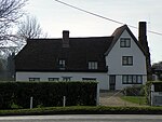
43 and 45 Benington Road
Aston
Timber Framed House
Mid-late 16th century
31 May 1984 TL2754022722 51°53′18″N 0°08′53″W / 51.888472°N 0.148171°W / 51.888472; -0.148171 (43 and 45 Benington Road ) 1175062 Upload Photo
Bayford House
Bayford House
Early 17th century
24 November 1966 TL3060707990 51°45′19″N 0°06′33″W / 51.75538°N 0.109183°W / 51.75538; -0.109183 (Bayford House ) 1101707 Upload Photo
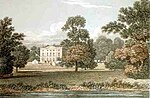
Bayfordbury
Bayford Country House
1759-62
20 October 1952 TL3153610448 51°46′38″N 0°05′41″W / 51.777251°N 0.094802°W / 51.777251; -0.094802 (Bayfordbury ) 1176752 Bayfordbury
Church of St Mary
Bayford
Church
Medieval
24 November 1966 TL3097408840 51°45′47″N 0°06′13″W / 51.762933°N 0.103549°W / 51.762933; -0.103549 (Church of St Mary ) 1101712 Church of St Mary
Benington Bury and Peterscourt
Benington House
Sold 1914
20 October 1952 TL2973423913 51°53′55″N 0°06′57″W / 51.898668°N 0.115862°W / 51.898668; -0.115862 (Benington Bury and Peterscourt ) 1101374 Upload Photo
Benington Lordship
Benington
Country House
Late 17th century
24 November 1966 TL2965923660 51°53′47″N 0°07′01″W / 51.896412°N 0.117046°W / 51.896412; -0.117046 (Benington Lordship ) 1101404 Benington Lordship
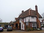
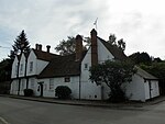
The Bell Public House
Benington
Cross Passage House
late medieval
20 October 1952 TL2992723569 51°53′44″N 0°06′47″W / 51.895532°N 0.113188°W / 51.895532; -0.113188 (The Bell Public House ) 1101413 The Bell Public House
Black Lion Inn
Bishop's Stortford House
Early 17th century
18 October 1949 TL4877621391 51°52′17″N 0°09′35″E / 51.871256°N 0.159608°E / 51.871256; 0.159608 (Black Lion Inn ) 1101601 Black Lion Inn
Boar's Head Inn
Bishop's Stortford
House
Late 16th century
18 October 1949 TL4859821372 51°52′16″N 0°09′25″E / 51.871133°N 0.157016°E / 51.871133; 0.157016 (Boar's Head Inn ) 1176189 Boar's Head Inn
10, High St (formerly Tissimans)
Bishop's Stortford
House
Early 19th century
18 October 1949 TL4865821400 51°52′17″N 0°09′28″E / 51.871368°N 0.157899°E / 51.871368; 0.157899 (10, High St (formerly Tissimans) ) 1101615 10, High St (formerly Tissimans)
8, High St (formerly Tissimans)
Bishop's Stortford
House
16th century
18 October 1949 TL4866621401 51°52′17″N 0°09′29″E / 51.871375°N 0.158015°E / 51.871375; 0.158015 (8, High St (formerly Tissimans) ) 1101614 8, High St (formerly Tissimans)
Bramfieldbury
Bramfield House
17th century
24 November 1966 TL2851215397 51°49′21″N 0°08′12″W / 51.822425°N 0.136777°W / 51.822425; -0.136777 (Bramfieldbury ) 1089159 Bramfieldbury
Braughing Bury
Green End, Braughing
House
Early 17th century
22 February 1967 TL3951925348 51°54′33″N 0°01′37″E / 51.909201°N 0.02684°E / 51.909201; 0.02684 (Braughing Bury ) 1347540 Upload Photo
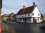
The Brown Bear Public House
Braughing House
17th century
22 February 1967 TL3975225133 51°54′26″N 0°01′48″E / 51.90721°N 0.030138°E / 51.90721; 0.030138 (The Brown Bear Public House ) 1296288 The Brown Bear Public House
The Old Rose and Crown
13 Church End, Braughing
Pub/House
c. 1600 22 February 1967 TL3958425218 51°54′29″N 0°01′40″E / 51.908016°N 0.027732°E / 51.908016; 0.027732 (The Old Rose and Crown ) 1102331 The Old Rose and Crown
Upp Hall
The Warren, Braughing
Country House
late 16th century or 17th century
19 October 1951 TL4072923954 51°53′47″N 0°02′38″E / 51.896371°N 0.04385°E / 51.896371; 0.04385 (Upp Hall ) 1102282 Upload Photo
Barn at Upp Hall (40m north-west of Mansion)
The Warren, Braughing
Barn
19th century
22 February 1967 TL4090824194 51°53′55″N 0°02′48″E / 51.898483°N 0.046547°E / 51.898483; 0.046547 (Barn at Upp Hall (40m north-west of Mansion) ) 1347531 Upload Photo
Beeches Farmhouse
Brent Pelham Farmhouse
18th century and 19th century
19 October 1951 TL4459530431 51°57′13″N 0°06′10″E / 51.953577°N 0.102714°E / 51.953577; 0.102714 (Beeches Farmhouse ) 1307905 Beeches Farmhouse
Buckland House
Buckland House
Early 18th century
22 February 1967 TL3563233818 51°59′11″N 0°01′35″W / 51.986266°N 0.026291°W / 51.986266; -0.026291 (Buckland House ) 1176027 Upload Photo
Church of St Andrew (Redundant Churches Fund)
Buckland
Parish Church
14th century
22 February 1967 TL3584433857 51°59′12″N 0°01′23″W / 51.986565°N 0.023191°W / 51.986565; -0.023191 (Church of St Andrew (Redundant Churches Fund) ) 1347742 Church of St Andrew (Redundant Churches Fund)
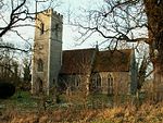
Former Church of St Bartholomew
Buntingford Parish Church (ruined)
Early 13th century
22 February 1967 TL3693830112 51°57′10″N 0°00′32″W / 51.952647°N 0.008762°W / 51.952647; -0.008762 (Former Church of St Bartholomew ) 1101329 Former Church of St Bartholomew
The Almhouses
Buntingford
Almshouse
1684
19 October 1951 TL3627329338 51°56′45″N 0°01′07″W / 51.945855°N 0.018739°W / 51.945855; -0.018739 (The Almhouses ) 1101350 The Almhouses
Victoria House
Buntingford
Jettied House
15th century
19 October 1951 TL3623129474 51°56′50″N 0°01′09″W / 51.947088°N 0.019296°W / 51.947088; -0.019296 (Victoria House ) 1101310 Upload Photo
Broadfield Hall Stables
Broadfield , Cottered Stable
c. 1619 6 July 1984 TL3244931005 51°57′42″N 0°04′25″W / 51.961757°N 0.073699°W / 51.961757; -0.073699 (Broadfield Hall Stables ) 1101292 Upload Photo
Holy Trinity Church
Throcking , Cottered Parish Church
13th century
22 February 1967 TL3383630165 51°57′14″N 0°03′14″W / 51.953877°N 0.053852°W / 51.953877; -0.053852 (Holy Trinity Church ) 1175183 Holy Trinity Church
Parish Church of St John the Baptist
Cottered Parish Church
Mid 14th century
22 February 1967 TL3174629215 51°56′45″N 0°05′05″W / 51.94584°N 0.08461°W / 51.94584; -0.08461 (Parish Church of St John the Baptist ) 1101295 Parish Church of St John the Baptist
Rumbolds
Flanders Green, Cottered
Jettied House
Early 16th century
22 February 1967 TL3254828501 51°56′21″N 0°04′24″W / 51.939233°N 0.073224°W / 51.939233; -0.073224 (Rumbolds ) 1175297 Upload Photo
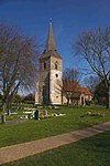
Church of All Saints
Datchworth Church
late 12th century or early 13th century
24 November 1966 TL2677419263 51°51′27″N 0°09′38″W / 51.857563°N 0.160565°W / 51.857563; -0.160565 (Church of All Saints ) 1341457 Church of All Saints
Staples Cottage
Datchworth Farmhouse
later 19th century
24 November 1966 TL2759919619 51°51′38″N 0°08′54″W / 51.860574°N 0.14846°W / 51.860574; -0.14846 (Staples Cottage ) 1175159 Upload Photo
Church of St Botolph
Eastwick Parish Church
13th century
24 January 1967 TL4340611651 51°47′07″N 0°04′39″E / 51.785147°N 0.077632°E / 51.785147; 0.077632 (Church of St Botolph ) 1101264 Church of St Botolph
Church of St Mary
Furneux Pelham Parish Church
Mid 13th century
22 February 1967 TL4316827953 51°55′54″N 0°04′51″E / 51.931681°N 0.080932°E / 51.931681; 0.080932 (Church of St Mary ) 1307889 Church of St Mary
Furneux Pelham Hall
Furneux Pelham
Manor House
Late 16th century
19 October 1951 TL4284328014 51°55′56″N 0°04′34″E / 51.932313°N 0.076234°E / 51.932313; 0.076234 (Furneux Pelham Hall ) 1176538 Furneux Pelham Hall
Gilston Park , 400m along Drive west-south-west from Cumberland Lodge
Gilston Country House
1852
24 January 1967 TL4410712906 51°47′46″N 0°05′18″E / 51.796243°N 0.088308°E / 51.796243; 0.088308 (Gilston Park, 400m along Drive west-south-west from Cumberland Lodge ) 1175745 Gilston Park , 400m along Drive west-south-west from Cumberland Lodge
Parish Church of St John the Baptist
Great Amwell Parish Church
11th century
24 January 1967 TL3718212508 51°47′40″N 0°00′44″W / 51.794407°N 0.012202°W / 51.794407; -0.012202 (Parish Church of St John the Baptist ) 1341839 Parish Church of St John the Baptist
Aisled Barn at Mundenbury (70m to south-east of House)
Great Munden Barn
17th century
24 January 1984 TL3561024202 51°54′00″N 0°01′49″W / 51.899868°N 0.0304°W / 51.899868; -0.0304 (Aisled Barn at Mundenbury (70m to south-east of House) ) 1173699 Upload Photo
Farmhouse at High Trees Farm (along Track 200m from Lane)
Great Munden Cross Passage House
Medieval
4 December 1951 TL3547621945 51°52′47″N 0°02′00″W / 51.87962°N 0.033232°W / 51.87962; -0.033232 (Farmhouse at High Trees Farm (along Track 200m from Lane) ) 1296238 Upload Photo
Mundenbury (60m to north-north-east of St Nicholas's Church)
Great Munden , Great MundenHouse
c. 1700 24 January 1967 TL3555124242 51°54′01″N 0°01′52″W / 51.900241°N 0.031242°W / 51.900241; -0.031242 (Mundenbury (60m to north-north-east of St Nicholas's Church) ) 1347555 Upload Photo
North Range of Farm Buildings at Peasfield (35m east-north-east of House)
Cherry Green, Great Munden
Farm Building
15th, 16th and 17th century
24 January 1984 TL3507925833 51°54′53″N 0°02′15″W / 51.914652°N 0.037474°W / 51.914652; -0.037474 (North Range of Farm Buildings at Peasfield (35m east-north-east of House) ) 1102285 Upload Photo
Parish Church of St Nicholas
Great Munden Parish Church
Early 12th century
24 January 1967 TL3551924185 51°53′59″N 0°01′54″W / 51.899737°N 0.031729°W / 51.899737; -0.031729 (Parish Church of St Nicholas ) 1173651 Parish Church of St Nicholas
Amores including Outbuildings
Hertingfordbury , HertfordHouse
Early to Mid 16th century
10 February 1950 TL3073611972 51°47′28″N 0°06′21″W / 51.791133°N 0.105818°W / 51.791133; -0.105818 (Amores including Outbuildings ) 1268719 Amores including Outbuildings
Bailey Hall
Hertford House
c. 1700 10 February 1950 TL3268412468 51°47′42″N 0°04′39″W / 51.795131°N 0.0774°W / 51.795131; -0.0774 (Bailey Hall ) 1268782 Bailey Hall
Bailey Walls, north-east range to Hertford Castle
Hertford Castle, Hertford
Castle
1171-1174
10 February 1950 TL3253112552 51°47′45″N 0°04′47″W / 51.795923°N 0.079586°W / 51.795923; -0.079586 (Bailey Walls, north-east range to Hertford Castle ) 1268984 Upload Photo
Bailey Walls, south-east range to Hertford Castle
Hertford Castle, Hertford
Castle
1171-1174
10 February 1950 TL3248412433 51°47′42″N 0°04′49″W / 51.794864°N 0.080312°W / 51.794864; -0.080312 (Bailey Walls, south-east range to Hertford Castle ) 1268985 Bailey Walls, south-east range to Hertford Castle
Beadle House
Bull Plain, Hertford
House
1702-1704
10 February 1950 TL3264712687 51°47′50″N 0°04′40″W / 51.797108°N 0.077853°W / 51.797108; -0.077853 (Beadle House ) 1268974 Beadle House
Bengeo Hall
Bengeo , HertfordHouse
Early 18th century
10 February 1950 TL3300313792 51°48′25″N 0°04′20″W / 51.806953°N 0.07227°W / 51.806953; -0.07227 (Bengeo Hall ) 1268712 Upload Photo
Bengeo Hall Stables
Bengeo, Hertford
Stables
Early to Mid 18th century
12 April 1973 TL3295213828 51°48′26″N 0°04′23″W / 51.807289°N 0.072995°W / 51.807289; -0.072995 (Bengeo Hall Stables ) 1268715 Upload Photo
Bridgeman House
Hertford
House
18th century
10 February 1950 TL3229912268 51°47′36″N 0°04′59″W / 51.793425°N 0.083056°W / 51.793425; -0.083056 (Bridgeman House ) 1268681 Upload Photo
Cecil House
Hertford
House
Earlier
10 February 1950 TL3228712587 51°47′47″N 0°04′59″W / 51.796295°N 0.083108°W / 51.796295; -0.083108 (Cecil House ) 1268744 Cecil House
Church of All Saints with St John
Hertford
Church
15th century and earlier
12 April 1973 TL3279912457 51°47′42″N 0°04′33″W / 51.795005°N 0.075738°W / 51.795005; -0.075738 (Church of All Saints with St John ) 1268783 Church of All Saints with St John
Church of St Mary and St John
Hertingfordbury, Hertford
Parish Church
13th century
10 February 1950 TL3085411948 51°47′27″N 0°06′15″W / 51.790889°N 0.104117°W / 51.790889; -0.104117 (Church of St Mary and St John ) 1268722 Church of St Mary and St John
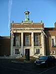
County Hall including Terraces and Fountain
Hertford
County hall
1935-1939
9 September 1996 TL3238111943 51°47′26″N 0°04′55″W / 51.790486°N 0.081992°W / 51.790486; -0.081992 (County Hall including Terraces and Fountain ) 1268807 County Hall including Terraces and Fountain
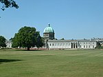
Goldings including Retaining Walls and Steps to Forecourt and Terrace
Goldings, Hertford
Country House
1650-1660
8 April 1968 TL3102914252 51°48′42″N 0°06′03″W / 51.811552°N 0.100711°W / 51.811552; -0.100711 (Goldings including Retaining Walls and Steps to Forecourt and Terrace ) 1268815 Goldings including Retaining Walls and Steps to Forecourt and Terrace
Lombard House
Hertford
House
Early 17th century
10 February 1950 TL3260712741 51°47′51″N 0°04′42″W / 51.797603°N 0.078412°W / 51.797603; -0.078412 (Lombard House ) 1268978 Lombard House
Morgans Junior School
Hertford
Elementary School
1948-1949
6 May 1998 TL3255211668 51°47′17″N 0°04′47″W / 51.787974°N 0.079619°W / 51.787974; -0.079619 (Morgans Junior School ) 1119734 Upload Photo
North Road House
Hertford
Villa
1827-1828
10 February 1950 TL3217912612 51°47′48″N 0°05′05″W / 51.796545°N 0.084664°W / 51.796545; -0.084664 (North Road House ) 1268839 Upload Photo
No 43 St Andrew St including St Nicholas Hall
Hertford
Apartment
1950
10 February 1950 TL3234012603 51°47′47″N 0°04′56″W / 51.796426°N 0.082334°W / 51.796426; -0.082334 (No 43 St Andrew St including St Nicholas Hall ) 1268740 No 43 St Andrew St including St Nicholas Hall
Old Cross Wharf
Hertford
Malt House
16th century
9 September 1996 TL3253412724 51°47′51″N 0°04′46″W / 51.797467°N 0.079476°W / 51.797467; -0.079476 (Old Cross Wharf ) 1268795 Old Cross Wharf
The Old Vicarage
Hertford
House
17th century
12 April 1973 TL3269412501 51°47′44″N 0°04′38″W / 51.795426°N 0.077243°W / 51.795426; -0.077243 (The Old Vicarage ) 1268954 Upload Photo
The Red House
Hertford
House
17th century
10 February 1950 TL3289612698 51°47′50″N 0°04′27″W / 51.797148°N 0.07424°W / 51.797148; -0.07424 (The Red House ) 1268915 Upload Photo
The Salisbury Arms
Hertford
Timber Framed House
Early 15th century
10 February 1950 TL3267412558 51°47′45″N 0°04′39″W / 51.795943°N 0.077511°W / 51.795943; -0.077511 (The Salisbury Arms ) 1268933 The Salisbury Arms
The Walnuts (No 23, Castle St) including Front Railings
Hertford
House
17th century
10 February 1950 TL3257812412 51°47′41″N 0°04′44″W / 51.794653°N 0.078958°W / 51.794653; -0.078958 (The Walnuts (No 23, Castle St) including Front Railings ) 1268945 The Walnuts (No 23, Castle St) including Front Railings
Warren Park, Warrenfield
Bengeo, Hertford
House
1970
10 February 1950 TL3236913342 51°48′11″N 0°04′54″W / 51.80306°N 0.081632°W / 51.80306; -0.081632 (Warren Park, Warrenfield ) 1269002 Upload Photo
Yeomanry House and attached Front Area Railings
Hertford
House
c. 1725 12 April 1973 TL3236312648 51°47′49″N 0°04′55″W / 51.796825°N 0.081984°W / 51.796825; -0.081984 (Yeomanry House and attached Front Area Railings ) 1268733 Yeomanry House and attached Front Area Railings
3–11 Fore Street
Hertford
Apartment
1950
10 February 1950 TL3264312569 51°47′46″N 0°04′41″W / 51.796049°N 0.077956°W / 51.796049; -0.077956 (3–11 Fore Street ) 1268928 3–11 Fore Street
42 Fore Street
Hertford
Apartment
c. 1825 10 February 1950 TL3270512572 51°47′46″N 0°04′37″W / 51.796061°N 0.077056°W / 51.796061; -0.077056 (42 Fore Street ) 1268937 42 Fore Street
130 Fore Street
Hertford
House
Early 19th century
10 February 1950 TL3286012643 51°47′48″N 0°04′29″W / 51.796662°N 0.074783°W / 51.796662; -0.074783 (130 Fore Street ) 1268918 130 Fore Street
2 St Andrew Street
Hertford
House
Early to Mid 18th century
10 February 1950 TL3243912673 51°47′49″N 0°04′51″W / 51.797032°N 0.080873°W / 51.797032; -0.080873 (2 St Andrew Street ) 1268763 Upload Photo
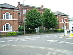
Main Quadrangle and Memorial Hall attached, at Haileybury and Imperial Service College
Hertford Heath Teachers House
1806
24 January 1967 TL3580810787 51°46′45″N 0°01′58″W / 51.779277°N 0.032786°W / 51.779277; -0.032786 (Main Quadrangle and Memorial Hall attached, at Haileybury and Imperial Service College ) 1084375 Main Quadrangle and Memorial Hall attached, at Haileybury and Imperial Service College
Woolmer's Park with attached Outbuildings and Wall
Letty Green, Hertingfordbury
Country House
18th century
20 October 1952 TL2856510243 51°46′34″N 0°08′17″W / 51.776098°N 0.137917°W / 51.776098; -0.137917 (Woolmer's Park with attached Outbuildings and Wall ) 1089105 Upload Photo
East Barn at Shingle Hall with Wall attached at south-west, 20m north-east of House
Trims Green, High Wych
Wall
Late 16th century
30 April 1985 TL4694317239 51°50′04″N 0°07′52″E / 51.834437°N 0.131239°E / 51.834437; 0.131239 (East Barn at Shingle Hall with Wall attached at south-west, 20m north-east of House ) 1220519 Upload Photo
Farmhouse at Blounts Farm
Allen's Green, High Wych
Farmhouse
15th century or early 16th century
22 February 1967 TL4572317946 51°50′28″N 0°06′50″E / 51.841109°N 0.113844°E / 51.841109; 0.113844 (Farmhouse at Blounts Farm ) 1220692 Upload Photo
Great Barn at Bursteads 35m north-east of House
Trims Green, High Wych
Aisled Barn
16th century
30 April 1985 TL4767217256 51°50′04″N 0°08′31″E / 51.834398°N 0.141819°E / 51.834398; 0.141819 (Great Barn at Bursteads 35m north-east of House ) 1290870 Upload Photo
North Barn at Shingle Hall 60m north-north-west of House
Trims Green, High Wych
Aisled Barn
14th century or early 15th century
30 April 1985 TL4688717283 51°50′05″N 0°07′50″E / 51.834847°N 0.130446°E / 51.834847; 0.130446 (North Barn at Shingle Hall 60m north-north-west of House ) 1220616 Upload Photo
Parish Church of St James the Great
High Wych
Parish Church
1860-61
22 February 1967 TL4635214131 51°48′24″N 0°07′17″E / 51.806667°N 0.121356°E / 51.806667; 0.121356 (Parish Church of St James the Great ) 1220513 Parish Church of St James the Great
Church of St Nicholas
Great Hormead , Hormead Parish Church
13th century or earlier
22 February 1967 TL3999229566 51°56′49″N 0°02′08″E / 51.946981°N 0.035426°E / 51.946981; 0.035426 (Church of St Nicholas ) 1101835 Church of St Nicholas
Great Hormead Dane
Great Hormead, Hormead
Cross Passage House
Late 16th century
22 February 1967 TL4041630141 51°57′07″N 0°02′31″E / 51.952041°N 0.041825°E / 51.952041; 0.041825 (Great Hormead Dane ) 1176619 Upload Photo
Hare Street House
Hare Street, Hormead
Timber Framed House
16th century
19 October 1951 TL3903729830 51°56′59″N 0°01′18″E / 51.949593°N 0.021647°E / 51.949593; 0.021647 (Hare Street House ) 1176454 Hare Street House
Oak Cottage
Hare Street, Hormead
Cross Wing House
15th century
22 February 1967 TL3902929422 51°56′45″N 0°01′17″E / 51.945929°N 0.021366°E / 51.945929; 0.021366 (Oak Cottage ) 1101855 Oak Cottage
The Brick House
Great Hormead, Hormead
Tower House
c. 1570 19 October 1951 TL4125831050 51°57′36″N 0°03′16″E / 51.959995°N 0.054442°E / 51.959995; 0.054442 (The Brick House ) 1307967 Upload Photo
The Old Rectory
Great Hormead, Hormead
Cross Wing House
c. 1500 22 February 1967 TL4033330111 51°57′06″N 0°02′26″E / 51.951792°N 0.040606°E / 51.951792; 0.040606 (The Old Rectory ) 1101825 Upload Photo
Old House
Hunsdon House
Late Medieval
4 December 1951 TL4181414435 51°48′38″N 0°03′21″E / 51.810567°N 0.055705°E / 51.810567; 0.055705 (Old House ) 1307772 Upload Photo
Olives Farm House along Track 220m from Road
Hunsdon
House
Later 17th century
4 December 1951 TL4080712652 51°47′41″N 0°02′25″E / 51.794801°N 0.040385°E / 51.794801; 0.040385 (Olives Farm House along Track 220m from Road ) 1101951 Upload Photo
Tanners
Hunsdon Farmhouse
Later 19th century
24 January 1967 TL4163314054 51°48′26″N 0°03′11″E / 51.80719°N 0.052926°E / 51.80719; 0.052926 (Tanners ) 1347692 Upload Photo
The Big Black Barn at Hunsdon Lodge Farm 500m along Track
Hunsdon
Barn
18th century
14 April 1983 TL4243614364 51°48′35″N 0°03′53″E / 51.809771°N 0.064693°E / 51.809771; 0.064693 (The Big Black Barn at Hunsdon Lodge Farm 500m along Track ) 1101968 The Big Black Barn at Hunsdon Lodge Farm 500m along Track
The Pump House
Hunsdon
House
17th century
24 January 1967 TL4181814172 51°48′30″N 0°03′20″E / 51.808203°N 0.055656°E / 51.808203; 0.055656 (The Pump House ) 1176452 Upload Photo
Little Berkhamsted House
Little Berkhamsted House
1732
20 October 1952 TL2926707988 51°45′20″N 0°07′43″W / 51.755673°N 0.128586°W / 51.755673; -0.128586 (Little Berkhamsted House ) 1341452 Upload Photo
Stratton's Tower
Little Berkhamsted House
1986
24 November 1966 TL2949508107 51°45′24″N 0°07′31″W / 51.756689°N 0.125241°W / 51.756689; -0.125241 (Stratton's Tower ) 1341449 Stratton's Tower
Ashmeads
Hadham Ford, Little Hadham
House
c. 1600 22 February 1967 TL4355221678 51°52′31″N 0°05′02″E / 51.875202°N 0.083902°E / 51.875202; 0.083902 (Ashmeads ) 1210460 Upload Photo
Clintons
Bury Green , Little HadhamHouse
16th century
19 October 1951 TL4497420984 51°52′07″N 0°06′15″E / 51.868599°N 0.104253°E / 51.868599; 0.104253 (Clintons ) 1290634 Upload Photo
Fiddlers Croft 250m along Drive beside Stonehouse Farm
Little Hadham House
c. 1603 22 February 1967 TL4446322412 51°52′54″N 0°05′51″E / 51.881562°N 0.097433°E / 51.881562; 0.097433 (Fiddlers Croft 250m along Drive beside Stonehouse Farm ) 1290063 Fiddlers Croft 250m along Drive beside Stonehouse Farm
Gatehouse Range at Hadham Hall 60m west of Hall
Little Hadham
Privy House
Early 16th century
22 February 1967 TL4517822766 51°53′04″N 0°06′29″E / 51.884557°N 0.107962°E / 51.884557; 0.107962 (Gatehouse Range at Hadham Hall 60m west of Hall ) 1211100 Gatehouse Range at Hadham Hall 60m west of Hall
Hadham Hall (Hadham Hall School)
Little Hadham
House
15th century
19 October 1957 TL4524922765 51°53′04″N 0°06′32″E / 51.88453°N 0.108993°E / 51.88453; 0.108993 (Hadham Hall (Hadham Hall School) ) 1211099 Hadham Hall (Hadham Hall School)
Lodge Farmhouse 140m from Road
Hadham Ford, Little Hadham
House
Mid 19th century
30 April 1985 TL4300022162 51°52′47″N 0°04′34″E / 51.879693°N 0.076089°E / 51.879693; 0.076089 (Lodge Farmhouse 140m from Road ) 1290605 Upload Photo
Lower Farmhouse
Bury Green, Little Hadham
House
17th century
19 October 1951 TL4521020981 51°52′07″N 0°06′28″E / 51.868511°N 0.107677°E / 51.868511; 0.107677 (Lower Farmhouse ) 1290740 Upload Photo
May Cottage and Gouldburn
Hadham Ford, Little Hadham
House
16th century
30 April 1985 TL4358421699 51°52′31″N 0°05′04″E / 51.875383°N 0.084375°E / 51.875383; 0.084375 (May Cottage and Gouldburn ) 1210437 Upload Photo
The Old Brick House and No. 2 Ford Hill
Hadham Ford, Little Hadham
House
17th century
22 February 1967 TL4354821597 51°52′28″N 0°05′02″E / 51.874476°N 0.08381°E / 51.874476; 0.08381 (The Old Brick House and No. 2 Ford Hill ) 1210461 Upload Photo
The Whare
Little Hadham
Hall House
17th century
22 February 1967 TL4402222747 51°53′05″N 0°05′28″E / 51.884686°N 0.09117°E / 51.884686; 0.09117 (The Whare ) 1220772 Upload Photo
Westfield
Westland Green, Little Hadham
House
Mid 17th century
30 April 1985 TL4236521512 51°52′26″N 0°04′00″E / 51.874015°N 0.066603°E / 51.874015; 0.066603 (Westfield ) 1211024 Upload Photo
Burnside Cottage & Hunts Cottage
Dane End , Little Munden House
17th century
24 January 1967 TL3324421329 51°52′29″N 0°03′57″W / 51.874622°N 0.065876°W / 51.874622; -0.065876 (Burnside Cottage & Hunts Cottage ) 1102267 Upload Photo
Church of St Mary
Meesdenbury, Meesden
Parish Church
Early 12th century
22 February 1967 TL4389532557 51°58′22″N 0°05′36″E / 51.97286°N 0.093425°E / 51.97286; 0.093425 (Church of St Mary ) 1347765 Church of St Mary
Bishops Folly, the Palace, the Palace East & the Palace West
Much Hadham Bishops Palace
Until 1647
19 October 1951 TL4307019722 51°51′28″N 0°04′34″E / 51.857751°N 0.076096°E / 51.857751; 0.076096 (Bishops Folly, the Palace, the Palace East & the Palace West ) 1213683 Upload Photo
Camwell Hall Farmhouse
Much Hadham
Farmhouse
Late 16th century
22 February 1967 TL4174617613 51°50′21″N 0°03′22″E / 51.839139°N 0.05602°E / 51.839139; 0.05602 (Camwell Hall Farmhouse ) 1211348 Upload Photo
Farmhouse at Yewtree Farm
Hadham Cross, Much Hadham
Continuous Jetty House
c. 1600 19 October 1951 TL4263718524 51°50′50″N 0°04′10″E / 51.847098°N 0.069319°E / 51.847098; 0.069319 (Farmhouse at Yewtree Farm ) 1213270 Upload Photo
Hoglands
Perry Green , Much HadhamHouse
17th century
22 February 1967 TL4384317429 51°50′13″N 0°05′11″E / 51.83695°N 0.086359°E / 51.83695; 0.086359 (Hoglands ) 1213427 Hoglands
Stable Block and adjoining Cottages at Moor Place
Kettle Green, Much Hadham
House
Early-mid 18th century
22 February 1967 TL4221818825 51°51′00″N 0°03′48″E / 51.849909°N 0.063364°E / 51.849909; 0.063364 (Stable Block and adjoining Cottages at Moor Place ) 1289133 Upload Photo
Stable Block at Much Hadham Hall
Much Hadham
Stable
c1726-9
22 February 1967 TL4282019333 51°51′16″N 0°04′20″E / 51.85432°N 0.072307°E / 51.85432; 0.072307 (Stable Block at Much Hadham Hall ) 1212818 Upload Photo
Stable Block at the Lordship
Much Hadham
Stable
Early 18th century
22 February 1967 TL4284419893 51°51′34″N 0°04′22″E / 51.859346°N 0.072887°E / 51.859346; 0.072887 (Stable Block at the Lordship ) 1212469 Upload Photo
The Forge, Forge Cottage and Horseshoe Cottage
Much Hadham
House
c. 1600 22 February 1967 TL4276219257 51°51′13″N 0°04′17″E / 51.853652°N 0.071435°E / 51.853652; 0.071435 (The Forge, Forge Cottage and Horseshoe Cottage ) 1289340 The Forge, Forge Cottage and Horseshoe Cottage
The Lordship
Much Hadham
House
16th century and early 17th century
22 February 1967 TL4289019866 51°51′33″N 0°04′25″E / 51.859091°N 0.073543°E / 51.859091; 0.073543 (The Lordship ) 1289499 The Lordship
The Old House
Much Hadham
House
1826
22 February 1967 TL4283219516 51°51′21″N 0°04′21″E / 51.855961°N 0.072557°E / 51.855961; 0.072557 (The Old House ) 1365721 The Old House
The Red House
Much Hadham
House
c. 1720 22 February 1967 TL4278419369 51°51′17″N 0°04′18″E / 51.854653°N 0.0718°E / 51.854653; 0.0718 (The Red House ) 1289286 The Red House
The White House
Much Hadham
House
17th century
22 February 1967 TL4277419291 51°51′14″N 0°04′18″E / 51.853955°N 0.071623°E / 51.853955; 0.071623 (The White House ) 1212950 The White House
Church of St Catherine
Sacombe Green , Sacombe Parish Church
14th century
24 November 1966 TL3360219360 51°51′25″N 0°03′41″W / 51.856843°N 0.06144°W / 51.856843; -0.06144 (Church of St Catherine ) 1045912 Church of St Catherine
Sacombe House with attached Service Blocks and Wall to East
Sacombe
Apartment
1966
24 November 1966 TL3392618977 51°51′12″N 0°03′25″W / 51.853324°N 0.056886°W / 51.853324; -0.056886 (Sacombe House with attached Service Blocks and Wall to East ) 1341455 Upload Photo
Aisled Barn 12m east of House at Redericks Farm
Sawbridgeworth Aisled Barn
C15/C16
2 October 1981 TL4633012827 51°47′42″N 0°07′14″E / 51.794957°N 0.120487°E / 51.794957; 0.120487 (Aisled Barn 12m east of House at Redericks Farm ) 1101617 Upload Photo
Falconers
Sawbridgeworth
House
?C17
2 October 1981 TL4747414180 51°48′25″N 0°08′16″E / 51.806813°N 0.137639°E / 51.806813; 0.137639 (Falconers ) 1101677 Upload Photo
Great Hyde Hall
Great Hyde Hall, Sawbridgeworth
Apartment
1978
6 October 1971 TL4958715397 51°49′02″N 0°10′08″E / 51.817186°N 0.168788°E / 51.817186; 0.168788 (Great Hyde Hall ) 1347838 Upload Photo
Lodges at South Entrance to Park of Great Hyde Hall
Great Hyde Hall, Sawbridgeworth
Gate Lodge
c. 1806 6 October 1971 TL4923715084 51°48′52″N 0°09′49″E / 51.814468°N 0.16358°E / 51.814468; 0.16358 (Lodges at South Entrance to Park of Great Hyde Hall ) 1176335 Lodges at South Entrance to Park of Great Hyde Hall
Pishiobury Park Mansion and attached Offices and Garden Walls and Norman Gateway
Pishiobury Park, SawbridgeworthCountry House
1580-90
6 June 1952 TL4808213412 51°47′59″N 0°08′46″E / 51.799752°N 0.146123°E / 51.799752; 0.146123 (Pishiobury Park Mansion and attached Offices and Garden Walls and Norman Gateway ) 1307762 Pishiobury Park Mansion and attached Offices and Garden Walls and Norman Gateway
Stable Block on South of Upper Courtyard at Pishiobury Park
Pishiobury Park, Sawbridgeworth
Gate
18th century
6 June 1952 TL4803513379 51°47′58″N 0°08′44″E / 51.799468°N 0.145428°E / 51.799468; 0.145428 (Stable Block on South of Upper Courtyard at Pishiobury Park ) 1176781 Upload Photo
The Market House
Sawbridgeworth
Cross Passage House
16th century
6 June 1952 TL4837614834 51°48′45″N 0°09′04″E / 51.81245°N 0.150992°E / 51.81245; 0.150992 (The Market House ) 1101644 The Market House
The Red House
Sawbridgeworth
House
c. 1700 6 June 1952 TL4820714883 51°48′47″N 0°08′55″E / 51.812935°N 0.148563°E / 51.812935; 0.148563 (The Red House ) 1101683 Upload Photo
19 Knight Street
Sawbridgeworth
House
20 years after 1800-10
2 October 1981 TL4843014996 51°48′50″N 0°09′07″E / 51.813892°N 0.151844°E / 51.813892; 0.151844 (19 Knight Street ) 1101680 Upload Photo
40 Knight Street
Sawbridgeworth
House
c. 1720 6 June 1952 TL4838014856 51°48′46″N 0°09′04″E / 51.812647°N 0.151059°E / 51.812647; 0.151059 (40 Knight Street ) 1101643 Upload Photo
Barn and Stables adjacent at Plashes Farm (40m north-east of House)
Colliers End , Standon Timber Framed House
16th century
4 October 1983 TL3799620363 51°51′53″N 0°00′10″E / 51.864788°N 0.002722°E / 51.864788; 0.002722 (Barn and Stables adjacent at Plashes Farm (40m north-east of House) ) 1308109 Upload Photo
Chapel at St Edmund's College (RC) (at North End of Main Building)
Old Hall Green , StandonChapel
1845-1853
24 January 1967 TL3718022128 51°52′51″N 0°00′30″W / 51.880848°N 0.00842°W / 51.880848; -0.00842 (Chapel at St Edmund's College (RC) (at North End of Main Building) ) 1308305 Upload Photo
Crown and Falcon Public House
Puckeridge , StandonInn
16th century
24 January 1967 TL3863323287 51°53′27″N 0°00′47″E / 51.890903°N 0.013141°E / 51.890903; 0.013141 (Crown and Falcon Public House ) 1176373 Crown and Falcon Public House
Farmhouse at Great Barwick Farm
Standon
Farmhouse
Mid 16th century
24 January 1967 TL3854318865 51°51′04″N 0°00′36″E / 51.851192°N 0.010061°E / 51.851192; 0.010061 (Farmhouse at Great Barwick Farm ) 1102382 Upload Photo
Knights Court
Standon
House
16th century or earlier
24 January 1967 TL3962822190 51°52′51″N 0°01′38″E / 51.880798°N 0.027146°E / 51.880798; 0.027146 (Knights Court ) 1347492 Upload Photo
Standon Lordship West, and Standon Lordship East (on West Back of River Rib 1 Km south of Standon Village)
Standon
Country House
c. 1872 4 December 1951 TL3925721444 51°52′27″N 0°01′17″E / 51.874188°N 0.021459°E / 51.874188; 0.021459 (Standon Lordship West, and Standon Lordship East (on West Back of River Rib 1 Km south of Standon Village) ) 1347501 Standon Lordship West, and Standon Lordship East (on West Back of River Rib 1 Km south of Standon Village)
West Barn at Great Barwick Farm (50m west of House)
Standon
Barn
14th century or earlier
23 November 1983 TL3849218880 51°51′05″N 0°00′34″E / 51.85134°N 0.009327°E / 51.85134; 0.009327 (West Barn at Great Barwick Farm (50m west of House) ) 1102383 Upload Photo
59 High Street
Standon
House
c. 1700 24 January 1967 TL3965222288 51°52′54″N 0°01′39″E / 51.881673°N 0.027534°E / 51.881673; 0.027534 (59 High Street ) 1176629 59 High Street
54, 56, 58 and 60 High Street
Puckeridge , StandonTimber Framed House
16th century or earlier
24 January 1967 TL3858523229 51°53′25″N 0°00′45″E / 51.890394°N 0.01242°E / 51.890394; 0.01242 (54, 56, 58 and 60 High Street ) 1347522 54, 56, 58 and 60 High Street
59 and 61 Cambridge Road
Colliers End, Standon
House
Early 16th century
24 January 1967 TL3713920746 51°52′06″N 0°00′34″W / 51.86844°N 0.009564°W / 51.86844; -0.009564 (59 and 61 Cambridge Road ) 1308335 Upload Photo
All Nations Christian College (Easneye Mansion)
Stanstead Abbots Country House
1867-8
30 September 1983 TL3806113430 51°48′09″N 0°00′03″E / 51.802475°N 0.000902°E / 51.802475; 0.000902 (All Nations Christian College (Easneye Mansion) ) 1078763 All Nations Christian College (Easneye Mansion)
Parish Church of St Andrew
Stanstead Abbotts Church
1881
24 January 1967 TL3868212151 51°47′27″N 0°00′34″E / 51.790829°N 0.009391°E / 51.790829; 0.009391 (Parish Church of St Andrew ) 1067774 Parish Church of St Andrew
Red Lion Public House
Stanstead Abbotts
Cross Wing House
Late 15th century
4 December 1957 TL3862311929 51°47′20″N 0°00′30″E / 51.788849°N 0.008448°E / 51.788849; 0.008448 (Red Lion Public House ) 1078754 Red Lion Public House
Stanstead Bury
Tarbets Hill, Stanstead Abbotts
Manor House
Late 15th century
4 December 1951 TL3999011190 51°46′55″N 0°01′41″E / 51.781869°N 0.027956°E / 51.781869; 0.027956 (Stanstead Bury ) 1051056 Upload Photo
Stanstead Hall
Stanstead Abbotts
House
1752
24 January 1967 TL3855611924 51°47′20″N 0°00′27″E / 51.788821°N 0.007475°E / 51.788821; 0.007475 (Stanstead Hall ) 1078756 Upload Photo
The Baesh Almshouses and attached Forecourt Wall
Stanstead Abbotts
Almshouses
C20
4 December 1951 TL3901511533 51°47′07″N 0°00′50″E / 51.785194°N 0.013969°E / 51.785194; 0.013969 (The Baesh Almshouses and attached Forecourt Wall ) 1078739 The Baesh Almshouses and attached Forecourt Wall
The Clock House
Stanstead Abbotts
House
1951
4 December 1951 TL3866111927 51°47′20″N 0°00′32″E / 51.788822°N 0.008998°E / 51.788822; 0.008998 (The Clock House ) 1356544 Upload Photo
Church of St Margaret (St Mary)
St Margarets Village, Stanstead St Margarets
Church
Norman
24 January 1967 TL3803411566 51°47′09″N 0°00′01″W / 51.785733°N 0.00023°W / 51.785733; -0.00023 (Church of St Margaret (St Mary) ) 1078703 Church of St Margaret (St Mary)
Church of St Mary the Virgin
Stapleford Parish Church
Mid 12th century
24 November 1966 TL3119216863 51°50′06″N 0°05′50″W / 51.834977°N 0.09736°W / 51.834977; -0.09736 (Church of St Mary the Virgin ) 1089119 Church of St Mary the Virgin
Church of St Michael and All Angels
Waterford , StaplefordParish Church
1871-2
11 June 1986 TL3126614668 51°48′55″N 0°05′50″W / 51.815235°N 0.097118°W / 51.815235; -0.097118 (Church of St Michael and All Angels ) 1089122 Church of St Michael and All Angels
Marden Hill House , Service Block and Annexe
Marden Hill, Tewin
Apartment
1986
20 October 1952 TL2793613988 51°48′36″N 0°08′44″W / 51.809896°N 0.145649°W / 51.809896; -0.145649 (Marden Hill House, Service Block and Annexe ) 1366605 Marden Hill House , Service Block and Annexe
Queen Hoo Hall
Queen Hoo Hall, Tewin
Country House
c1575-80
20 October 1952 TL2787416129 51°49′45″N 0°08′45″W / 51.82915°N 0.145758°W / 51.82915; -0.145758 (Queen Hoo Hall ) 1089097 Queen Hoo Hall
Aisled Barn at Thorley Hall 60m north of House
Thorley Aisled Barn
16th century or earlier
22 February 1967 TL4766218910 51°50′57″N 0°08′33″E / 51.849261°N 0.142379°E / 51.849261; 0.142379 (Aisled Barn at Thorley Hall 60m north of House ) 1213945 Upload Photo
Thorley Hall
Thorley
House
c1390-1414
19 October 1951 TL4768818844 51°50′55″N 0°08′34″E / 51.848661°N 0.142728°E / 51.848661; 0.142728 (Thorley Hall ) 1213803 Thorley Hall
Twyford House
Twyford House, Thorley
Apartment
1970
22 February 1967 TL4933119306 51°51′09″N 0°10′00″E / 51.852375°N 0.166763°E / 51.852375; 0.166763 (Twyford House ) 1213957 Upload Photo
Balhams Hall and the Cottage
High Cross , Thundridge House
15th century
24 January 1967 TL3626118515 51°50′55″N 0°01′23″W / 51.848608°N 0.023187°W / 51.848608; -0.023187 (Balhams Hall and the Cottage ) 1347496 Upload Photo
Fabdens (on North Bank of River Rib)
Thundridge House
Late 15th century
24 January 1967 TL3718017306 51°50′15″N 0°00′37″W / 51.83752°N 0.010333°W / 51.83752; -0.010333 (Fabdens (on North Bank of River Rib) ) 1175911 Upload Photo
Farmhouse at Sutes Farm
High Cross, Thundridge
Farmhouse
14th century
4 December 1951 TL3664119000 51°51′10″N 0°01′03″W / 51.852874°N 0.017482°W / 51.852874; -0.017482 (Farmhouse at Sutes Farm ) 1347494 Upload Photo
Hanbury Manor
Thundridge
Country House
1890-1
24 January 1967 TL3512016289 51°49′44″N 0°02′26″W / 51.828883°N 0.04061°W / 51.828883; -0.04061 (Hanbury Manor ) 1204101 Hanbury Manor
Remains of Old Church of St Mary and All Saints
Thundridge Bury, Thundridge
Wall
17th century
24 January 1967 TL3681017335 51°50′16″N 0°00′56″W / 51.837871°N 0.015688°W / 51.837871; -0.015688 (Remains of Old Church of St Mary and All Saints ) 1077953 Remains of Old Church of St Mary and All Saints
Sawtrees Manor
Thundridge
Hall House
15th century or Earlier
24 January 1967 TL3873017973 51°50′35″N 0°00′45″E / 51.843131°N 0.012417°E / 51.843131; 0.012417 (Sawtrees Manor ) 1204250 Upload Photo
Stable Block at Youngsbury (60m north of House)
High Cross, Thundridge
Stable
c. 1769 24 January 1967 TL3688417957 51°50′36″N 0°00′52″W / 51.843442°N 0.014369°W / 51.843442; -0.014369 (Stable Block at Youngsbury (60m north of House) ) 1176876 Upload Photo
The Old Waggon
Thundridge
House
Late Medieval
24 January 1967 TL3628318516 51°50′55″N 0°01′22″W / 51.848612°N 0.022868°W / 51.848612; -0.022868 (The Old Waggon ) 1102369 Upload Photo
Westmill House
Westmill, Thundridge
House
Early 17th century
24 January 1967 TL3386416299 51°49′45″N 0°03′32″W / 51.829275°N 0.058821°W / 51.829275; -0.058821 (Westmill House ) 1205184 Upload Photo
Dovecote at Manor Farm (30m south of House)
Walkern Dovecote
c. 1700 4 February 1959 TL2895426500 51°55′20″N 0°07′34″W / 51.922096°N 0.126225°W / 51.922096; -0.126225 (Dovecote at Manor Farm (30m south of House) ) 1175945 Dovecote at Manor Farm (30m south of House)
Farmhouse at Bridgefoot Farm
Church End, Walkern
Farmhouse
Mid 15th century
20 October 1952 TL2918426525 51°55′20″N 0°07′22″W / 51.922268°N 0.122873°W / 51.922268; -0.122873 (Farmhouse at Bridgefoot Farm ) 1347976 Upload Photo
Farmhouse at Manor Farm
Walkern
Farmhouse
c. 1700 20 October 1952 TL2895226539 51°55′21″N 0°07′34″W / 51.922447°N 0.126239°W / 51.922447; -0.126239 (Farmhouse at Manor Farm ) 1348003 Upload Photo
Farmhouse at Rooks Nest Farm
Finches End, Walkern
Farmhouse
Mid 17th century
20 October 1952 TL2868725875 51°55′00″N 0°07′49″W / 51.916542°N 0.130338°W / 51.916542; -0.130338 (Farmhouse at Rooks Nest Farm ) 1176006 Upload Photo
Oakbeam
Walkern
House
c. 1700 24 November 1966 TL2904826645 51°55′24″N 0°07′29″W / 51.923377°N 0.124804°W / 51.923377; -0.124804 (Oakbeam ) 1101353 Oakbeam
The Old Rectory (at North End of Village, to West of Church)
Walkern
House
1984
24 November 1966 TL2917226729 51°55′27″N 0°07′23″W / 51.924104°N 0.12297°W / 51.924104; -0.12297 (The Old Rectory (at North End of Village, to West of Church) ) 1175855 The Old Rectory (at North End of Village, to West of Church)
Amwell House, Hertford Regional College
Ware House
Early 18th century
8 May 1950 TL3587613962 51°48′28″N 0°01′50″W / 51.80779°N 0.030558°W / 51.80779; -0.030558 (Amwell House, Hertford Regional College ) 1274726 Amwell House, Hertford Regional College
Churchgate House
Ware
Apartment
1995
14 March 1974 TL3569714385 51°48′42″N 0°01′59″W / 51.811635°N 0.032988°W / 51.811635; -0.032988 (Churchgate House ) 1238426 Upload Photo
Gazebo Within the Garden of Former Amwell House
Ware
Gazebo
c. 1768 8 May 1950 TL3567413828 51°48′24″N 0°02′01″W / 51.806635°N 0.033539°W / 51.806635; -0.033539 (Gazebo Within the Garden of Former Amwell House ) 1275397 Gazebo Within the Garden of Former Amwell House
Gilpin House
Ware
House
Mid 17th century
8 May 1950 TL3573514354 51°48′41″N 0°01′57″W / 51.811347°N 0.032449°W / 51.811347; -0.032449 (Gilpin House ) 1237905 Upload Photo
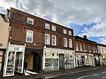
Nos 61, 61a, 61b, and 63, High St including Doorway to No 59 (not included)
Ware
Jettied House
Late C14-Early 15th century
8 May 1950 TL3575814314 51°48′40″N 0°01′56″W / 51.810982°N 0.032131°W / 51.810982; -0.032131 (Nos 61, 61a, 61b, and 63, High St including Doorway to No 59 (not included) ) 1237718 Upload Photo
The French Horn Inn
Ware
Jettied House
16th century
8 May 1950 TL3584814337 51°48′40″N 0°01′51″W / 51.811167°N 0.030817°W / 51.811167; -0.030817 (The French Horn Inn ) 1237669 Upload Photo
The Manor House
Ware
House
Earlier
8 May 1950 TL3571014485 51°48′45″N 0°01′58″W / 51.81253°N 0.03276°W / 51.81253; -0.03276 (The Manor House ) 1221873 The Manor House
The Old Stables
Ware
House
1977
14 March 1974 TL3590414333 51°48′40″N 0°01′48″W / 51.811117°N 0.030007°W / 51.811117; -0.030007 (The Old Stables ) 1221845 Upload Photo
Ware Library
Ware
Managers House
Mid-Late 18th century
8 May 1950 TL3565214353 51°48′41″N 0°02′01″W / 51.811358°N 0.033653°W / 51.811358; -0.033653 (Ware Library ) 1237923 Upload Photo
2 West Street
Ware
Kitchen
c. 1260 14 March 1974 TL3579214344 51°48′40″N 0°01′54″W / 51.811243°N 0.031627°W / 51.811243; -0.031627 (2 West Street ) 1274208 Upload Photo
1 Bluecoat Yard
Ware
House
Late 17th century
8 May 1950 TL3589614344 51°48′40″N 0°01′48″W / 51.811218°N 0.030119°W / 51.811218; -0.030119 (1 Bluecoat Yard ) 1221555 Upload Photo
2 Bluecoat Yard
Ware
Timber Framed House
17th century
8 May 1950 TL3589614347 51°48′40″N 0°01′48″W / 51.811245°N 0.030118°W / 51.811245; -0.030118 (2 Bluecoat Yard ) 1221594 Upload Photo
3–12 Bluecoat Yard
Ware
Houses
Mid 19th century Before 1851
8 May 1950 TL3589414384 51°48′42″N 0°01′48″W / 51.811578°N 0.030132°W / 51.811578; -0.030132 (3–12 Bluecoat Yard ) 1217408 3–12 Bluecoat Yard
65, 67, 67a High Street
Ware
House
C20
8 May 1950 TL3573314309 51°48′39″N 0°01′57″W / 51.810943°N 0.032496°W / 51.810943; -0.032496 (65, 67, 67a High Street ) 1274504 65, 67, 67a High Street
35, 35a, 37a (part) High Street
Ware
Apartment
1995
8 May 1950 TL3585514275 51°48′38″N 0°01′51″W / 51.810608°N 0.03074°W / 51.810608; -0.03074 (35, 35a, 37a (part) High Street ) 1217428 Upload Photo
Fanhams Hall with Buildings on Courtyard
Wareside Country House/Hotel
Early 18th century
24 January 1967 TL3718615656 51°49′22″N 0°00′39″W / 51.822692°N 0.010899°W / 51.822692; -0.010899 (Fanhams Hall with Buildings on Courtyard ) 1281155 Fanhams Hall with Buildings on Courtyard
New Hall
Newhall Green, Wareside
House
17th century
24 January 1967 TL3899616214 51°49′38″N 0°00′56″E / 51.827259°N 0.015569°E / 51.827259; 0.015569 (New Hall ) 1077970 New Hall
Church of St Andrew and St Mary
Watton-at-Stone Parish Church
Earlier
24 November 1966 TL3024118881 51°51′12″N 0°06′37″W / 51.853333°N 0.110394°W / 51.853333; -0.110394 (Church of St Andrew and St Mary ) 1341464 Church of St Andrew and St Mary
Watton Place and attached Garden Wall
Watton at Stone Kitchen
19th century
20 October 1952 TL2999219422 51°51′30″N 0°06′50″W / 51.858252°N 0.113804°W / 51.858252; -0.113804 (Watton Place and attached Garden Wall ) 1089070 Watton Place and attached Garden Wall
Barn Range at Westmill Bury Farm (100m north of the Bury)
Westmill Village, Westmill
Barn
early C20
19 October 1951 TL3709627172 51°55′34″N 0°00′27″W / 51.926191°N 0.007635°W / 51.926191; -0.007635 (Barn Range at Westmill Bury Farm (100m north of the Bury) ) 1174004 Upload Photo
Parish Church of St Mary the Virgin (church of England)
Westmill Parish Church
Pre conquest
22 February 1967 TL3694427171 51°55′34″N 0°00′35″W / 51.926219°N 0.009845°W / 51.926219; -0.009845 (Parish Church of St Mary the Virgin (church of England) ) 1173980 Parish Church of St Mary the Virgin (church of England)
Westmill Bury
Westmill
House
c. 1710 22 February 1967 TL3709627069 51°55′31″N 0°00′28″W / 51.925266°N 0.007676°W / 51.925266; -0.007676 (Westmill Bury ) 1347548 Upload Photo
Parish Church of St John the Baptist
Widford Anglican Church
1887-8
24 January 1967 TL4132615795 51°49′22″N 0°02′57″E / 51.822911°N 0.049186°E / 51.822911; 0.049186 (Parish Church of St John the Baptist ) 1101926 Parish Church of St John the Baptist
Wall forming West Boundary of Church Yard with Classical Gateway
Widford, East Hertfordshire
Gate
Mid 16th century
24 January 1967 TL4130115788 51°49′22″N 0°02′56″E / 51.822854°N 0.048821°E / 51.822854; 0.048821 (Wall forming West Boundary of Church Yard with Classical Gateway ) 1176928 Upload Photo
Corneybury
Wyddial, East Hertfordshire
Manor House
Late 16th century
19 October 1951 TL3581130706 51°57′30″N 0°01′30″W / 51.95826°N 0.024916°W / 51.95826; -0.024916 (Corneybury ) 1101809 Upload Photo
Wyddial Hall
Wyddial Country House
Early 16th century
19 October 1951 TL3740431850 51°58′05″N 0°00′05″W / 51.968148°N 0.001291°W / 51.968148; -0.001291 (Wyddial Hall ) 1307579 Wyddial Hall