Name
Location
Type
Completed Date designated
Grid ref. Entry number Image
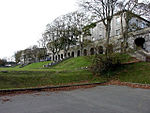
Amphitheatre in Grounds of Saltram House
Saltram Park, City of Plymouth
Garden Wall
Late 18th century
1 May 1975 SX5133355640 50°22′55″N 4°05′33″W / 50.381811°N 4.092397°W / 50.381811; -4.092397 (Amphitheatre in Grounds of Saltram House ) 1386231 Amphitheatre in Grounds of Saltram House
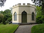
Garden Temple (known as Fannys Bower) in Grounds of Saltram House
Saltram Park, City of Plymouth
Belvedere
Late 18th century
1 May 1975 SX5194155764 50°22′59″N 4°05′02″W / 50.383079°N 4.0839°W / 50.383079; -4.0839 (Garden Temple (known as Fannys Bower) in Grounds of Saltram House ) 1386235 Garden Temple (known as Fannys Bower) in Grounds of Saltram House
Gardenhouse at Saltram House
Saltram Park, City of Plymouth
Summerhouse
c. 1772 29 March 1960 SX5158755692 50°22′56″N 4°05′20″W / 50.382343°N 4.088847°W / 50.382343; -4.088847 (Gardenhouse at Saltram House ) 1386234 Gardenhouse at Saltram House
Orangery at Saltram House
Saltram Park, City of Plymouth
Orangery
1773
29 March 1960 SX5190555723 50°22′58″N 4°05′04″W / 50.382702°N 4.08439°W / 50.382702; -4.08439 (Orangery at Saltram House ) 1386238 Orangery at Saltram House
Stable Block at Saltram House
Saltram Park, City of Plymouth
Coachmans Cottage
Mid 18th century
29 March 1960 SX5210455541 50°22′52″N 4°04′53″W / 50.381116°N 4.081521°W / 50.381116; -4.081521 (Stable Block at Saltram House ) 1386240 Stable Block at Saltram House
Gate Piers approximately 550 Metres South East of Saltram House
Saltram Park, City of Plymouth
Gate Pier
1 May 1975 SX5255855358 50°22′47″N 4°04′30″W / 50.379585°N 4.075068°W / 50.379585; -4.075068 (Gate Piers approximately 550 Metres South East of Saltram House ) 1386236 Upload Photo
Armada Memorial
Hoe , City of PlymouthCommemorative Monument
1888
1 May 1975 SX4777953903 50°21′55″N 4°08′30″W / 50.365291°N 4.141645°W / 50.365291; -4.141645 (Armada Memorial ) 1386461 Armada Memorial
Belmont House (Youth Hostel) Belmont Place
Stoke , City of PlymouthVilla
1820
1 May 1975 SX4611155569 50°22′47″N 4°09′57″W / 50.379829°N 4.165762°W / 50.379829; -4.165762 (Belmont House (Youth Hostel) Belmont Place ) 1130060 Upload Photo
Boringdon Arch (triumphal Arch) and Triumphal Arch Cottage and Outbuilding
Plympton , City of PlymouthWall
1783
1 May 1975 SX5278157796 50°24′06″N 4°04′22″W / 50.401552°N 4.072889°W / 50.401552; -4.072889 (Boringdon Arch (triumphal Arch) and Triumphal Arch Cottage and Outbuilding ) 1386330 Upload Photo
Building 13 (Receipt and Issue Magazine), RNOD, Bull Point
Royal Naval Ordnance Depot, Bull Point, City of Plymouth
Magazine
1853 to 1857
17 April 2009 SX4344657824 50°23′58″N 4°12′15″W / 50.39939°N 4.204155°W / 50.39939; -4.204155 (Building 13 (Receipt and Issue Magazine), RNOD, Bull Point ) 1393253 Upload Photo
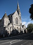
Church of St Andrew, Stoke Damarel
Stoke, City of Plymouth
Parish Church
15th century
25 January 1954 SX4633055001 50°22′29″N 4°09′45″W / 50.374782°N 4.162452°W / 50.374782; -4.162452 (Church of St Andrew, Stoke Damarel ) 1386305 Church of St Andrew, Stoke Damarel
Church of St Aubyn including attached Walls and Walls to North and South
Devonport , City of PlymouthGate Pier
1771
25 January 1954 SX4545954697 50°22′19″N 4°10′28″W / 50.371821°N 4.174566°W / 50.371821; -4.174566 (Church of St Aubyn including attached Walls and Walls to North and South ) 1130019 Upload Photo
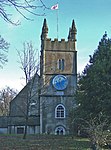
Church of St Budeaux
St Budeaux , City of PlymouthParish Church
C13/C14
25 January 1954 SX4542859285 50°24′47″N 4°10′37″W / 50.413044°N 4.17689°W / 50.413044; -4.17689 (Church of St Budeaux ) 1130049 Church of St Budeaux
Church of St Edward, King of the West Saxons
Eggbuckland , City of PlymouthParish Church
c. 1430 25 January 1954 SX4979757797 50°24′03″N 4°06′53″W / 50.400806°N 4.114848°W / 50.400806; -4.114848 (Church of St Edward, King of the West Saxons ) 1130025 Church of St Edward, King of the West Saxons
Church of St Mary
Tamerton Foliot , City of PlymouthParish Church
12th century
25 January 1954 SX4715260825 50°25′38″N 4°09′12″W / 50.427335°N 4.153272°W / 50.427335; -4.153272 (Church of St Mary ) 1386426 Church of St Mary
Church of St Mary and All Saints
Plymstock , City of PlymouthParish Church
15th century
29 March 1960 SX5172353012 50°21′30″N 4°05′09″W / 50.358291°N 4.085879°W / 50.358291; -4.085879 (Church of St Mary and All Saints ) 1330541 Church of St Mary and All Saints
Church of St Mary Blessed Virgin
Plympton, City of Plymouth
Church
14th century
29 March 1960 SX5377156319 50°23′19″N 4°03′30″W / 50.388525°N 4.058393°W / 50.388525; -4.058393 (Church of St Mary Blessed Virgin ) 1386222 Church of St Mary Blessed Virgin
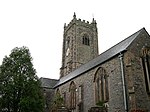
Church of St Maurice
Plympton St Maurice, City of Plymouth
Parish Church
15th century
29 March 1960 SX5458255759 50°23′01″N 4°02′48″W / 50.383694°N 4.046776°W / 50.383694; -4.046776 (Church of St Maurice ) 1130037 Church of St Maurice
Church of St Paul
Stonehouse , City of PlymouthAnglican Church
1831
25 January 1954 SX4642453757 50°21′49″N 4°09′38″W / 50.363627°N 4.160623°W / 50.363627; -4.160623 (Church of St Paul ) 1117102 Church of St Paul
Covered Slip (S 180)
Devonport Dockyard, City of Plymouth
Slip Shed
1814
13 August 1999 SX4515154007 50°21′56″N 4°10′43″W / 50.36554°N 4.17861°W / 50.36554; -4.17861 (Covered Slip (S 180) ) 1388431 Covered Slip (S 180)
Custom House
Barbican , City of PlymouthCustom House
1820
1 May 1975 SX4818754223 50°22′06″N 4°08′10″W / 50.368272°N 4.136041°W / 50.368272; -4.136041 (Custom House ) 1386460 Custom House
Devonport High School for Boys
Stoke, City of Plymouth
School
1998
9 November 1998 SX4637954932 50°22′27″N 4°09′42″W / 50.374174°N 4.161735°W / 50.374174; -4.161735 (Devonport High School for Boys ) 1386309 Devonport High School for Boys
Dockyard Museum, Former Office (SO 32)
Devonport Dockyard, City of Plymouth
Fireproof Building
c. 1780 13 August 1999 SX4497254625 50°22′16″N 4°10′53″W / 50.371046°N 4.18138°W / 50.371046; -4.18138 (Dockyard Museum, Former Office (SO 32) ) 1388408 Dockyard Museum, Former Office (SO 32)
Dockyard Wall Extending Approximately 300 Metres to South East Side Royal William Victualling Yard
Stonehouse, City of Plymouth
Wall
1830-1831
13 August 1999 SX4632353542 50°21′42″N 4°09′43″W / 50.361668°N 4.161954°W / 50.361668; -4.161954 (Dockyard Wall Extending Approximately 300 Metres to South East Side Royal William Victualling Yard ) 1378537 Upload Photo
Dovecote at Hardwick Farm
Hardwick, City of Plymouth
Dovecote
Late Medieval or 16th century
29 March 1960 SX5341055258 50°22′44″N 4°03′47″W / 50.3789°N 4.063054°W / 50.3789; -4.063054 (Dovecote at Hardwick Farm ) 1319610 Upload Photo
Drake Statue
Hoe, City of Plymouth
Statue
1884
1 May 1975 SX4770053902 50°21′55″N 4°08′34″W / 50.365262°N 4.142754°W / 50.365262; -4.142754 (Drake Statue ) 1386462 Drake Statue
Education Offices (former Grammar School)
Plympton St Maurice, City of Plymouth
Local Government Office
1952
23 April 1952 SX5462255726 50°23′00″N 4°02′46″W / 50.383407°N 4.046201°W / 50.383407; -4.046201 (Education Offices (former Grammar School) ) 1322035 Education Offices (former Grammar School)
Eggbuckland Keep
City of Plymouth
Keep
Late 1860s to 1872
16 July 2004 SX5000858107 50°24′13″N 4°06′43″W / 50.403646°N 4.112005°W / 50.403646; -4.112005 (Eggbuckland Keep ) 1390897 Upload Photo
Elizabethan House Museum
Barbican, City of Plymouth
House
1926
25 January 1954 SX4825154057 50°22′00″N 4°08′06″W / 50.366797°N 4.135075°W / 50.366797; -4.135075 (Elizabethan House Museum ) 1386279 Elizabethan House Museum
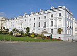
Elliot Terrace, Numbers 1 to 8 including 6a and Walls and Gate Piers
Hoe, City of Plymouth
Terrace
Mid 19th century
1 May 1975 SX4751353953 50°21′56″N 4°08′43″W / 50.365672°N 4.145402°W / 50.365672; -4.145402 (Elliot Terrace, Numbers 1 to 8 including 6a and Walls and Gate Piers ) 1386463 Elliot Terrace, Numbers 1 to 8 including 6a and Walls and Gate Piers
Former Palace Theatre and Great Western Hotel
Stonehouse, City of Plymouth
Hotel
1898
24 October 1974 SX4694554396 50°22′10″N 4°09′13″W / 50.369505°N 4.153563°W / 50.369505; -4.153563 (Former Palace Theatre and Great Western Hotel ) 1386483 Former Palace Theatre and Great Western Hotel
Former Royal Naval Hospital: the Quadrangle Centre, High St., the Quadrangle Centre Creykes, Gordon, Fellowes, Lyster and Sandon, Evans, Hornby, Dudding, Pryn and Norbury Court, Craigie Drive.
Stonehouse, City of Plymouth
House
Mid 1990s
1 May 1975 SX4659354661 50°22′18″N 4°09′31″W / 50.371795°N 4.158617°W / 50.371795; -4.158617 (Former Royal Naval Hospital: the Quadrangle Centre, High St., the Quadrangle Centre Creykes, Gordon, Fellowes, Lyster and Sandon, Evans, Hornby, Dudding, Pryn and Norbury Court, Craigie Drive. ) 1113296 Upload Photo
Former Royal Naval Hospital Water Tower
Stonehouse, City of Plymouth
Cistern
1758-1780
1 May 1975 SX4676154819 50°22′24″N 4°09′23″W / 50.373259°N 4.156321°W / 50.373259; -4.156321 (Former Royal Naval Hospital Water Tower ) 1113325 Upload Photo
HMS Drake Wardroom, Officers Quarters and Mess
Devonport, City of Plymouth
Officers Mess
1898-1902
1 May 1975 SX4499756685 50°23′22″N 4°10′55″W / 50.389565°N 4.181878°W / 50.389565; -4.181878 (HMS Drake Wardroom, Officers Quarters and Mess ) 1386376 Upload Photo
Hooe Manor
Plymstock, City of Plymouth
Apartment
1960
29 March 1960 SX5016352207 50°21′02″N 4°06′27″W / 50.350661°N 4.107474°W / 50.350661; -4.107474 (Hooe Manor ) 1330563 Upload Photo
Kings Hill Gazebo (S 186)
Devonport Dockyard, City of Plymouth
Gazebo
1822
13 August 1999 SX4516454042 50°21′57″N 4°10′42″W / 50.365858°N 4.178442°W / 50.365858; -4.178442 (Kings Hill Gazebo (S 186) ) 1388430 Upload Photo
Manadon House
Crownhill , City of PlymouthHouse
16th century
1 May 1975 SX4799358366 50°24′20″N 4°08′26″W / 50.405455°N 4.140444°W / 50.405455; -4.140444 (Manadon House ) 1386217 Upload Photo
Morice Gate, Two Gatehouses (MO 39 and 65) and attached Dockyard Walls
Devonport Dockyard, City of Plymouth
Gate
1720-1724
13 August 1999 SX4496654893 50°22′24″N 4°10′54″W / 50.373453°N 4.181575°W / 50.373453; -4.181575 (Morice Gate, Two Gatehouses (MO 39 and 65) and attached Dockyard Walls ) 1378549 Upload Photo
Mountbatten Tower
Plymstock, City of Plymouth
Coastal Battery
1660s
1 May 1975 SX4864453251 50°21′35″N 4°07′45″W / 50.359655°N 4.129229°W / 50.359655; -4.129229 (Mountbatten Tower ) 1386253 Mountbatten Tower
Mutley Baptist Church Including Spurgeon Hall and Caretakers Cottage
Mutley , City of PlymouthHouse
1907
4 June 1996 SX4837955626 50°22′51″N 4°08′02″W / 50.380931°N 4.133909°W / 50.380931; -4.133909 (Mutley Baptist Church Including Spurgeon Hall and Caretakers Cottage ) 1386261 Mutley Baptist Church Including Spurgeon Hall and Caretakers Cottage
North Smithery (SO 23)
Devonport Dockyard, City of Plymouth
Blacksmiths Workshop
1808
13 August 1999 SX4486254618 50°22′15″N 4°10′59″W / 50.370954°N 4.182922°W / 50.370954; -4.182922 (North Smithery (SO 23) ) 1388402 Upload Photo
Number 1, The Crescent and attached Forecourt Wall and Railings
Hoe, City of Plymouth
Terraced House
c. 1833 25 January 1954 SX4748054236 50°22′06″N 4°08′46″W / 50.368206°N 4.145981°W / 50.368206; -4.145981 (Number 1, The Crescent and attached Forecourt Wall and Railings ) 1386444 Upload Photo
No 1 Basin and No 1 Dock, including associated bollards and capstans
Devonport Dockyard, City of Plymouth
Capstan
1897
13 August 1999 SX4472354485 50°22′09″N 4°11′01″W / 50.36914134548291°N 4.183700559396869°W / 50.36914134548291; -4.183700559396869 (No 1 Basin and No 1 Dock, including associated bollards and capstans ) 1388409 Upload Photo
No 2 Dock, including bollards and capstans
Devonport Dockyard, City of Plymouth
Capstan
1897
15 January 2016 SX4471854563 50°22′11″N 4°11′02″W / 50.36983935375521°N 4.183813212170632°W / 50.36983935375521; -4.183813212170632 (No 2 Dock, including bollards and capstans ) 1432153 Upload Photo
No 3 Dock, including bollards and capstans
Devonport Dockyard, City of Plymouth
Capstan
1897
15 January 2016 SX4470054621 50°22′13″N 4°11′03″W / 50.37035601014251°N 4.184092161899382°W / 50.37035601014251; -4.184092161899382 (No 3 Dock, including bollards and capstans ) 1432208 Upload Photo
No 4 Dock, including bollards and capstans
Devonport Dockyard, City of Plymouth
Capstan
1897
15 January 2016 SX4470054676 50°22′15″N 4°11′03″W / 50.37084871031729°N 4.1841028907349775°W / 50.37084871031729; -4.1841028907349775 (No 4 Dock, including bollards and capstans ) 1432211 Upload Photo
Number 12 the Painted Canvas Store (MO 46)
Devonport Dockyard, City of Plymouth
House
1777
13 August 1999 SX4487054880 50°22′24″N 4°10′59″W / 50.373311°N 4.182918°W / 50.373311; -4.182918 (Number 12 the Painted Canvas Store (MO 46) ) 1378552 Upload Photo
Number 16 Store the Powder House (MO 42)
Devonport Dockyard, City of Plymouth
Powder Magazine
1744
13 August 1999 SX4490554958 50°22′26″N 4°10′57″W / 50.374021°N 4.182459°W / 50.374021; -4.182459 (Number 16 Store the Powder House (MO 42) ) 1378553 Upload Photo
Number 2 Store and Former Furbishers Shop (MO 68)
Devonport Dockyard, City of Plymouth
Carriage House
c. 1776 13 August 1999 SX4485054781 50°22′21″N 4°10′59″W / 50.372416°N 4.183158°W / 50.372416; -4.183158 (Number 2 Store and Former Furbishers Shop (MO 68) ) 1378550 Upload Photo
Number 4 Store (MO 70)
Devonport Dockyard, City of Plymouth
Ordnance Store
1722-1723
13 August 1999 SX4481654792 50°22′21″N 4°11′01″W / 50.372506°N 4.183641°W / 50.372506; -4.183641 (Number 4 Store (MO 70) ) 1378551 Upload Photo
Officers House Number 1 and attached Walls and Railings, Royal William Victualling Yard
Cremyll St, Stonehouse, City of Plymouth
Naval Officers House
1830-1832
13 August 1999 SX4628153548 50°21′42″N 4°09′45″W / 50.361711°N 4.162546°W / 50.361711; -4.162546 (Officers House Number 1 and attached Walls and Railings, Royal William Victualling Yard ) 1378538 Upload Photo
Officers House Number 2 and attached Walls and Railings, Royal William Victualling Yard
Cremyll St, Stonehouse, City of Plymouth7
Naval Officers House
1830-1832
13 August 1999 SX4626453575 50°21′43″N 4°09′46″W / 50.361949°N 4.162796°W / 50.361949; -4.162796 (Officers House Number 2 and attached Walls and Railings, Royal William Victualling Yard ) 1378539 Upload Photo
Officers Terrace (SO 59) and attached Basement Area Railings
Devonport Dockyard, City of Plymouth
House
Early 19th century
1 May 1975 SX4495754540 50°22′13″N 4°10′54″W / 50.370278°N 4.181555°W / 50.370278; -4.181555 (Officers Terrace (SO 59) and attached Basement Area Railings ) 1378525 Upload Photo
Old Custom House
Barbican, City of Plymouth
Merchants House
1586
25 January 1954 SX4814654174 50°22′04″N 4°08′12″W / 50.367821°N 4.136598°W / 50.367821; -4.136598 (Old Custom House ) 1386456 Old Custom House
Pair of Gate Piers at Entrance to Boringdon Hall
Boringdon, City of Plymouth
Gate Pier
Late 17th century
1 May 1975 SX5394057744 50°24′05″N 4°03′24″W / 50.401374°N 4.056572°W / 50.401374; -4.056572 (Pair of Gate Piers at Entrance to Boringdon Hall ) 1330577 Upload Photo
Plym Bridge (that Part in South Hams District)
City of Plymouth
Road Bridge
Earlier
23 April 1952 SX5236458714 50°24′35″N 4°04′45″W / 50.409698°N 4.079114°W / 50.409698; -4.079114 (Plym Bridge (that Part in South Hams District) ) 1162902 Plym Bridge (that Part in South Hams District)
Railings, Piers and Gateway to Kings Hill Gazebo
Devonport Dockyard, City of Plymouth
Gate
1822
13 August 1999 SX4517654045 50°21′57″N 4°10′42″W / 50.365888°N 4.178274°W / 50.365888; -4.178274 (Railings, Piers and Gateway to Kings Hill Gazebo ) 1388429 Upload Photo
Rear Retaining Wall Extending approximately 400 Metres, Royal William Victualling Yard
Stonehouse, City of Plymouth
Stonemasons Yard
1827-1831
13 August 1999 SX4618353491 50°21′40″N 4°09′50″W / 50.361173°N 4.1639°W / 50.361173; -4.1639 (Rear Retaining Wall Extending approximately 400 Metres, Royal William Victualling Yard ) 1378541 Upload Photo
Remains of Castle
City of Plymouth
Keep
12th century or early 13th century
29 March 1960 SX5448055755 50°23′01″N 4°02′54″W / 50.383632°N 4.048208°W / 50.383632; -4.048208 (Remains of Castle ) 1129995 Upload Photo
Royal Citadel Governors House and Steps to Doorways
The Barbican, City of Plymouth
Steps
Mid to Late C20
8 July 1998 SX4800853878 50°21′54″N 4°08′18″W / 50.365126°N 4.138417°W / 50.365126; -4.138417 (Royal Citadel Governors House and Steps to Doorways ) 1067143 Upload Photo
Royal Citadel Great Store
The Barbican, City of Plymouth
Barracks
1844
8 July 1998 SX4811453763 50°21′51″N 4°08′13″W / 50.36412°N 4.136881°W / 50.36412; -4.136881 (Royal Citadel Great Store ) 1067144 Upload Photo
Royal Marine Barracks Archway Block
Stonehouse, City of Plymouth
Guardhouse
1867-1871
1 May 1975 SX4636454053 50°21′59″N 4°09′42″W / 50.366271°N 4.161586°W / 50.366271; -4.161586 (Royal Marine Barracks Archway Block ) 1117103 Upload Photo
Royal Marine Barracks East Barrack Block and Forecourt Railings
Stonehouse, City of Plymouth
Barracks
1781-1783
1 May 1975 SX4645054068 50°21′59″N 4°09′37″W / 50.366428°N 4.160384°W / 50.366428; -4.160384 (Royal Marine Barracks East Barrack Block and Forecourt Railings ) 1117106 Upload Photo
Royal Marine Barracks North Barrack Block and Attached Basement Railings
Stonehouse, City of Plymouth
Barracks
c. 1860 1 May 1975 SX4639154128 50°22′01″N 4°09′40″W / 50.366952°N 4.161238°W / 50.366952; -4.161238 (Royal Marine Barracks North Barrack Block and Attached Basement Railings ) 1244639 Upload Photo
Royal Marine Barracks Officers Mess
Stonehouse, City of Plymouth
Courtyard
1779-1785
1 May 1975 SX4643853969 50°21′56″N 4°09′38″W / 50.365536°N 4.160512°W / 50.365536; -4.160512 (Royal Marine Barracks Officers Mess ) 1244640 Upload Photo
Royal Marine Barracks South Block and Attached Basement Railings
Stonehouse, City of Plymouth
Railings
Late 19th century
1 May 1975 SX4640553976 50°21′56″N 4°09′40″W / 50.36559°N 4.160979°W / 50.36559; -4.160979 (Royal Marine Barracks South Block and Attached Basement Railings ) 1244644 Upload Photo
Royal Marine Barracks South West Block and Attached Front Basement Railings
Stonehouse, City of Plymouth
Apartment
1907
1 May 1975 SX4637453978 50°21′56″N 4°09′41″W / 50.3656°N 4.161415°W / 50.3656; -4.161415 (Royal Marine Barracks South West Block and Attached Front Basement Railings ) 1244642 Upload Photo
Royal Marine Barracks the Longroom
Stonehouse, City of Plymouth
Assembly Rooms
1760
1 May 1975 SX4651653804 50°21′51″N 4°09′34″W / 50.364073°N 4.159349°W / 50.364073; -4.159349 (Royal Marine Barracks the Longroom ) 1244646 Upload Photo
Sherwell Church and associated Buildings Including Shelly Hall
City of Plymouth
Church Hall
1864
18 November 1991 SX4811355044 50°22′32″N 4°08′15″W / 50.375632°N 4.137413°W / 50.375632; -4.137413 (Sherwell Church and associated Buildings Including Shelly Hall ) 1386295 Sherwell Church and associated Buildings Including Shelly Hall
South Saw Mills (S 128, 148, 149, 150)
Devonport Dockyard, City of Plymouth
Fireproof Building
1856-1859
13 August 1999 SX4498654180 50°22′01″N 4°10′52″W / 50.367051°N 4.181°W / 50.367051; -4.181 (South Saw Mills (S 128, 148, 149, 150) ) 1388413 Upload Photo
South Smithery (building S 126)
Royal Naval Dockyard, City of Plymouth
Blacksmiths Workshop
1771
4 March 2008 SX4493554234 50°22′03″N 4°10′54″W / 50.367523°N 4.181738°W / 50.367523; -4.181738 (South Smithery (building S 126) ) 1392692 Upload Photo
St Dunstans Abbey and attached Road Frontage Walls
Stonehouse, City of Plymouth
Abbey
1850
1 May 1975 SX4693954980 50°22′29″N 4°09′14″W / 50.374752°N 4.153885°W / 50.374752; -4.153885 (St Dunstans Abbey and attached Road Frontage Walls ) 1386299 Upload Photo
St Dunstans Abbey School and Attached Road Frontage Walls
Stonehouse, City of Plymouth
Abbey
1850
1 May 1975 SX4687954927 50°22′27″N 4°09′17″W / 50.37426°N 4.154706°W / 50.37426; -4.154706 (St Dunstans Abbey School and Attached Road Frontage Walls ) 1386300 Upload Photo
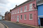
St Michaels Lodge and Rear Basement Court Railings
Stoke, City of Plymouth
Villa
1827
1 May 1975 SX4588655129 50°22′33″N 4°10′07″W / 50.375816°N 4.168743°W / 50.375816; -4.168743 (St Michaels Lodge and Rear Basement Court Railings ) 1130059 Upload Photo
Steps Dwarf Walls Lamps and Retaining Wall to Gardens Fronting Officers Terrace
Devonport Dockyard, City of Plymouth
Wall
1722
13 August 1999 SX4488254834 50°22′22″N 4°10′58″W / 50.372901°N 4.182731°W / 50.372901; -4.182731 (Steps Dwarf Walls Lamps and Retaining Wall to Gardens Fronting Officers Terrace ) 1378554 Upload Photo
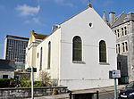
Plymouth Synagogue
City of Plymouth
Synagogue
1762
25 January 1954 SX4786954354 50°22′10″N 4°08′26″W / 50.369368°N 4.140563°W / 50.369368; -4.140563 (Plymouth Synagogue ) 1130015 Plymouth Synagogue
Tarred Yarn Store
Devonport Dockyard, City of Plymouth
Storehouse
1769
13 August 1999 SX4521754200 50°22′02″N 4°10′40″W / 50.367291°N 4.177762°W / 50.367291; -4.177762 (Tarred Yarn Store ) 1378504 Upload Photo
Tarring and Wheel House (S 136) and Tarred Yarn House (S 137)
Devonport Dockyard, City of Plymouth
Tar House
1763
13 August 1999 SX4520554238 50°22′03″N 4°10′41″W / 50.36763°N 4.177946°W / 50.36763; -4.177946 (Tarring and Wheel House (S 136) and Tarred Yarn House (S 137) ) 1378505 Upload Photo
The Distillery Public House, former Coates Gin Distillery
Barbican, City of Plymouth
First Floor Hall House
c. 1500 25 January 1954 SX4805354159 50°22′04″N 4°08′16″W / 50.367663°N 4.137898°W / 50.367663; -4.137898 (The Distillery Public House, former Coates Gin Distillery ) 1386410 The Distillery Public House, former Coates Gin Distillery
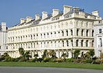
The Esplanade Numbers 1 to 8 and Forecourt Walls and Railings
Hoe, City of Plymouth
Villa
1836
25 January 1954 SX4759853947 50°21′56″N 4°08′39″W / 50.36564°N 4.144205°W / 50.36564; -4.144205 (The Esplanade Numbers 1 to 8 and Forecourt Walls and Railings ) 1386468 The Esplanade Numbers 1 to 8 and Forecourt Walls and Railings
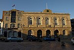
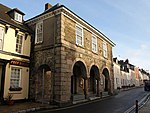
The Guildhall
Plympton
Guildhall
1696
23 April 1952 SX5439555697 50°22′59″N 4°02′58″W / 50.38309°N 4.04938°W / 50.38309; -4.04938 (The Guildhall ) 1244435 The Guildhall
The Officers Terrace (MO 63) and attached Railings, Rear Walls and Outbuildings
Devonport Dockyard, City of Plymouth
House
1975
1 May 1975 SX4491254833 50°22′22″N 4°10′56″W / 50.3729°N 4.182309°W / 50.3729; -4.182309 (The Officers Terrace (MO 63) and attached Railings, Rear Walls and Outbuildings ) 1378564 Upload Photo
The Rectory
City of Plymouth
House
Late 19th century
23 April 1952 SX5454355671 50°22′58″N 4°02′50″W / 50.382893°N 4.04729°W / 50.382893; -4.04729 (The Rectory ) 1244424 The Rectory
The Retreat
Plymstock, City of Plymouth
Detached House
Late 18th century
29 March 1960 SX5022452245 50°21′04″N 4°06′24″W / 50.351018°N 4.106632°W / 50.351018; -4.106632 (The Retreat ) 1330566 Upload Photo
Devonport Dockyard: The Scrieve Board (S 162)
Devonport Dockyard, City of Plymouth
Mould Loft
1814-1821
13 August 1999 SX4485954124 50°21′59″N 4°10′58″W / 50.366514°N 4.182761°W / 50.366514; -4.182761 (Devonport Dockyard: The Scrieve Board (S 162) ) 1388417 Upload Photo
Tudor Lodge
City of Plymouth
Merchants House
17th century
29 March 1960 SX5443855672 50°22′58″N 4°02′56″W / 50.382876°N 4.048766°W / 50.382876; -4.048766 (Tudor Lodge ) 1244395 Upload Photo
Walls and Bollards to Number 3 Basin
Devonport Dockyard, City of Plymouth
Wall
1844-1848
13 August 1999 SX4487455635 50°22′48″N 4°10′59″W / 50.380097°N 4.183173°W / 50.380097; -4.183173 (Walls and Bollards to Number 3 Basin ) 1378569 Upload Photo
White Yarn House (S 135)
Devonport Dockyard, City of Plymouth
Yarn House
1763
13 August 1999 SX4518554296 50°22′05″N 4°10′42″W / 50.368146°N 4.178251°W / 50.368146; -4.178251 (White Yarn House (S 135) ) 1378503 Upload Photo
33 St Andrews Street
City of Plymouth
House
Late 16th century
25 January 1954 SX4794354301 50°22′08″N 4°08′22″W / 50.36891°N 4.139501°W / 50.36891; -4.139501 (33 St Andrews Street ) 1386362 33 St Andrews Street
36 New Street
Barbican, City of Plymouth
House
Early 17th century
1 May 1975 SX4821854066 50°22′01″N 4°08′08″W / 50.366869°N 4.135542°W / 50.366869; -4.135542 (36 New Street ) 1386283 Upload Photo
Nos. 17 and 18 New Street
Barbican, City of Plymouth
Jettied House
1599
25 January 1954 SX4825954074 50°22′01″N 4°08′06″W / 50.366952°N 4.13497°W / 50.366952; -4.13497 (Nos. 17 and 18 New Street ) 1386272 Upload Photo
34 New Street
Barbican, City of Plymouth
Merchants House
17th century
25 January 1954 SX4823554063 50°22′01″N 4°08′07″W / 50.366847°N 4.135302°W / 50.366847; -4.135302 (34 New Street ) 1386281 Upload Photo
36 Looe Street
Barbican, City of Plymouth
House
C20
25 January 1954 SX4812954369 50°22′10″N 4°08′13″W / 50.36957°N 4.136915°W / 50.36957; -4.136915 (36 Looe Street ) 1386208 Upload Photo
Western Morning News
Derriford, City of Plymouth
Office and production facilities
1992
22 July 2015 SX4955659261 50°24′50″N 4°07′08″W / 50.413901°N 4.118823°W / 50.413901; -4.118823 (Western Morning News ) 1425964 Western Morning News
Swing Bridge, Royal William Victualling Yard
Cremyll St, Stonehouse, City of Plymouth
Swing bridge
c1833-5
13 August 1999 SX4608853631 50°21′45″N 4°09′55″W / 50.362407°N 4.165292°W / 50.362407; -4.165292 (Swing Bridge, Royal William Victualling Yard ) 1378540 Upload Photo