Name
Location
Type
Completed Date designated
Grid ref. Entry number Image
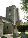
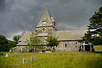
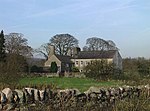
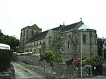
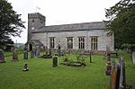
Church of Cuthbert
Aldingham , South LakelandChurch
c. 1190 25 March 1970 SD2834571034 54°07′49″N 3°05′53″W / 54.13014°N 3.098049°W / 54.13014; -3.098049 (Church of Cuthbert ) 1335944 Church of Cuthbert
Arnside Tower
Arnside , South LakelandTower House
Ruin
12 February 1962 SD4587876837 54°11′04″N 2°49′51″W / 54.184437°N 2.830818°W / 54.184437; -2.830818 (Arnside Tower ) 1312275 Arnside Tower
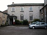
Beckside House
Barbon , South LakelandHouse
1767
12 February 1962 SD6270082715 54°14′20″N 2°34′26″W / 54.238765°N 2.573801°W / 54.238765; -2.573801 (Beckside House ) 1312337 Upload Photo
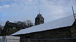
Church of St Bartholomew
Barbon, South Lakeland
Church
1893
21 February 1989 SD6305082462 54°14′11″N 2°34′06″W / 54.236517°N 2.5684°W / 54.236517; -2.5684 (Church of St Bartholomew ) 1086928 Church of St Bartholomew
Ashton House
Beetham , South LakelandHouse
Mid 18th century
21 November 1952 SD4959579467 54°12′30″N 2°46′28″W / 54.208451°N 2.774309°W / 54.208451; -2.774309 (Ashton House ) 1087330 Ashton House
Beetham Hall and attached Outbuildings
Beetham, South Lakeland
House
later alterations
21 November 1952 SD4992079055 54°12′17″N 2°46′09″W / 54.204781°N 2.769258°W / 54.204781; -2.769258 (Beetham Hall and attached Outbuildings ) 1312254 Beetham Hall and attached Outbuildings
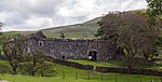
Curtain wall about 30m north of Beetham Hall
Beetham, South Lakeland
Curtain Wall
Medieval
21 November 1952 SD4993479114 54°12′19″N 2°46′09″W / 54.205312°N 2.769053°W / 54.205312; -2.769053 (Curtain wall about 30m north of Beetham Hall ) 1137542 Curtain wall about 30m north of Beetham Hall
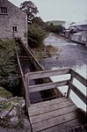
Heron Corn Mill and attached Mill Race
Beetham, South Lakeland
Corn Mill
Late 18th century or earlier
1 July 1974 SD4962179969 54°12′47″N 2°46′26″W / 54.212965°N 2.773995°W / 54.212965; -2.773995 (Heron Corn Mill and attached Mill Race ) 1087334 Heron Corn Mill and attached Mill Race
Church of St Peter
Field Broughton , Broughton East , South LakelandChurch
1892-4
25 March 1970 SD3870581776 54°13′41″N 2°56′30″W / 54.228011°N 2.941725°W / 54.228011; -2.941725 (Church of St Peter ) 1349025 Church of St Peter
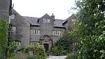
Broughton Tower special school
Broughton in Furness , Broughton West , South LakelandHouse
14th century
18 May 1953 SD2139787917 54°16′51″N 3°12′32″W / 54.280823°N 3.208773°W / 54.280823; -3.208773 (Broughton Tower special school ) 1335949 Broughton Tower special school
Obelisk and Stocks
Broughton-in-Furness , Broughton West, South LakelandObelisk
1810
25 March 1970 SD2122387580 54°16′40″N 3°12′41″W / 54.277768°N 3.211356°W / 54.277768; -3.211356 (Obelisk and Stocks ) 1086822 Obelisk and Stocks
Burton House, North Wing; Burton House, South Wing; Burton House and Rear Garden Wall attached to South Wing and Forming Rear Wa
Burton-in-Kendal , South LakelandHouse
Late 18th century
12 February 1962 SD5303276215 54°10′46″N 2°43′16″W / 54.179554°N 2.721109°W / 54.179554; -2.721109 (Burton House, North Wing; Burton House, South Wing; Burton House and Rear Garden Wall attached to South Wing and Forming Rear Wa ) 1087316 Burton House, North Wing; Burton House, South Wing; Burton House and Rear Garden Wall attached to South Wing and Forming Rear Wa
Entrance Lodge to south of Broadleys
Cartmel Fell , South LakelandLodge
1898-1900
13 May 1972 SD3931393262 54°19′53″N 2°56′05″W / 54.331298°N 2.934734°W / 54.331298; -2.934734 (Entrance Lodge to south of Broadleys ) 1266564 Upload Photo
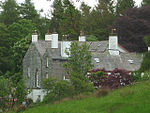
Hodge Hill
Cartmel Fell, South Lakeland
House
1560
18 May 1953 SD4184888162 54°17′09″N 2°53′41″W / 54.285764°N 2.894762°W / 54.285764; -2.894762 (Hodge Hill ) 1289621 Hodge Hill
Casterton Hall, East Wing, the Mews (includes the Orangery)
Casterton , South LakelandHouse
Early 19th century
21 November 1952 SD6195379398 54°12′32″N 2°35′05″W / 54.2089°N 2.58484°W / 54.2089; -2.58484 (Casterton Hall, East Wing, the Mews (includes the Orangery) ) 1335933 Casterton Hall, East Wing, the Mews (includes the Orangery)
Friends' Meeting House
Colthouse, Claife , South Lakeland
Schoolroom
1688
25 March 1970 SD3588798174 54°22′30″N 2°59′18″W / 54.375016°N 2.988469°W / 54.375016; -2.988469 (Friends' Meeting House ) 1087266 Friends' Meeting House
Hill Top
Near Sawrey , Claife, South LakelandFarmhouse
17th century or early 18th century
25 March 1970 SD3700995563 54°21′06″N 2°58′14″W / 54.351694°N 2.970646°W / 54.351694; -2.970646 (Hill Top ) 1087304 Hill Top
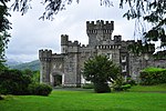
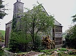
Wray Castle
Wray, Claife, South Lakeland
House
1840-47
25 March 1970 NY3749701014 54°24′03″N 2°57′51″W / 54.400736°N 2.964286°W / 54.400736; -2.964286 (Wray Castle ) 1106324 Wray Castle
The Cragg, Cragg Cottage and Barn
Colthouse, Claife, South Lakeland
House
1695
25 March 1970 SD3594198535 54°22′42″N 2°59′16″W / 54.378267°N 2.987715°W / 54.378267; -2.987715 (The Cragg, Cragg Cottage and Barn ) 1087263 The Cragg, Cragg Cottage and Barn
Church of St Peter
Finsthwaite , Colton , South LakelandChurch
1973-9
23 July 1987 SD3688387826 54°16′56″N 2°58′15″W / 54.282155°N 2.970945°W / 54.282155; -2.970945 (Church of St Peter ) 1225177 Church of St Peter
Nibthwaite Mill
Nibthwaite, Colton, South Lakeland
House
1987
23 July 1987 SD2946488292 54°17′07″N 3°05′06″W / 54.285371°N 3.084986°W / 54.285371; -3.084986 (Nibthwaite Mill ) 1225382 Upload Photo
Rook How Friends' Meeting House and Cottage
Rusland , Colton, South LakelandHouse
1725
25 March 1970 SD3322389542 54°17′50″N 3°01′39″W / 54.297109°N 3.027535°W / 54.297109; -3.027535 (Rook How Friends' Meeting House and Cottage ) 1225464 Rook How Friends' Meeting House and Cottage
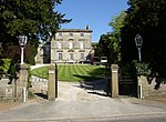
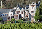
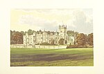
Brantwood
Coniston , South LakelandHouse
c. 1797 25 March 1970 SD3125895854 54°21′13″N 3°03′33″W / 54.353565°N 3.059178°W / 54.353565; -3.059178 (Brantwood ) 1335727 Brantwood
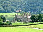
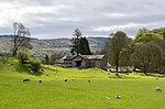
Coniston Hall
Haws Bank, Coniston, South Lakeland
Farmhouse
1953
18 May 1953 SD3048396364 54°21′29″N 3°04′16″W / 54.358042°N 3.07122°W / 54.358042; -3.07122 (Coniston Hall ) 1119652 Coniston Hall
Lodge and former Stable approx 70m to south of Brantwood
Coniston, South Lakeland
Stable
18th century
22 September 1987 SD3123495798 54°21′11″N 3°03′34″W / 54.353059°N 3.059535°W / 54.353059; -3.059535 (Lodge and former Stable approx 70m to south of Brantwood ) 1087283 Lodge and former Stable approx 70m to south of Brantwood
Cowmire Hall and Wall running Approx 20m to East, with Gate Piers
Crosthwaite and Lyth , South LakelandHouse
17th century
21 November 1952 SD4275188713 54°17′27″N 2°52′52″W / 54.290818°N 2.880998°W / 54.290818; -2.880998 (Cowmire Hall and Wall running Approx 20m to East, with Gate Piers ) 1087118 Cowmire Hall and Wall running Approx 20m to East, with Gate Piers
Biggerside Farmhouse
Dentdale , Dent , South LakelandFarmhouse
1690
14 June 1984 SD7001487733 54°17′04″N 2°27′44″W / 54.284344°N 2.46209°W / 54.284344; -2.46209 (Biggerside Farmhouse ) 1383820 Upload Photo
Burton Hill Farmhouse including adjoining Outbuilding
Dentdale, Dent, South Lakeland
Farmhouse
Probably mid to later 17th century
14 June 1984 SD6724989851 54°18′12″N 2°30′17″W / 54.303207°N 2.504792°W / 54.303207; -2.504792 (Burton Hill Farmhouse including adjoining Outbuilding ) 1383829 Upload Photo
High Hall Farmhouse including Cartshed
Dentdale, Dent, South Lakeland
Farmhouse
1625
16 March 1954 SD7037587610 54°17′00″N 2°27′24″W / 54.283259°N 2.456533°W / 54.283259; -2.456533 (High Hall Farmhouse including Cartshed ) 1383893 High Hall Farmhouse including Cartshed
High House
Gawthrop , Dent, South LakelandFarmhouse
1687
16 March 1954 SD6926186858 54°16′35″N 2°28′25″W / 54.276435°N 2.473565°W / 54.276435; -2.473565 (High House ) 1383968 Upload Photo
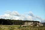
Newland Blast Furnace and attached ancillary Buildings
Newland, Egton with Newland , South Lakeland
Blast furnace
Late 18th century or earlier
14 April 1993 SD2999879709 54°12′30″N 3°04′29″W / 54.20832°N 3.074777°W / 54.20832; -3.074777 (Newland Blast Furnace and attached ancillary Buildings ) 1096782 Newland Blast Furnace and attached ancillary Buildings
Plumpton Hall
Egton with Newland, South Lakeland
House
Mid to late 16th century
18 May 1953 SD3128778718 54°11′59″N 3°03′17″W / 54.19959°N 3.054791°W / 54.19959; -3.054791 (Plumpton Hall ) 1158458 Plumpton Hall
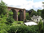
Lune Viaduct (that Part in Firbank CP)
Marthwaite, Firbank , South Lakeland
Railway Viaduct
1857-61
14 June 1984 SD6306493054 54°19′54″N 2°34′10″W / 54.331706°N 2.569497°W / 54.331706; -2.569497 (Lune Viaduct (that Part in Firbank CP) ) 1086911 Lune Viaduct (that Part in Firbank CP)
Badger Dub and Stable or Shippon attached to South West
Garsdale, South Lakeland
Farmhouse
Probably early 18th century
14 June 1984 SD7231290629 54°18′38″N 2°25′37″W / 54.3105°N 2.427063°W / 54.3105; -2.427063 (Badger Dub and Stable or Shippon attached to South West ) 1384006 Upload Photo
Dandra Garth
Garsdale , South LakelandFarmhouse
Probably late 17th century
16 March 1954 SD7532989705 54°18′08″N 2°22′50″W / 54.302351°N 2.380616°W / 54.302351; -2.380616 (Dandra Garth ) 1384014 Dandra Garth
East Rackenthwaite and adjoining Barn
Garsdale, South Lakeland
Farmhouse
Probably 16th century or early 17th century
11 August 1978 SD7323190326 54°18′28″N 2°24′46″W / 54.307826°N 2.412911°W / 54.307826; -2.412911 (East Rackenthwaite and adjoining Barn ) 1384019 East Rackenthwaite and adjoining Barn
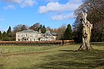
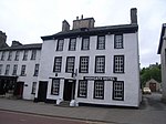
Netherwood Hotel
Grange-over-Sands , South LakelandHotel
1893
2 May 1975 SD4142678401 54°11′53″N 2°53′58″W / 54.198002°N 2.899333°W / 54.198002; -2.899333 (Netherwood Hotel ) 1269682 Netherwood Hotel
Clock Tower Works
Low Wood, Haverthwaite , South Lakeland
Gunpowder Works
1849
2 September 1985 SD3466583679 54°14′41″N 3°00′15″W / 54.244611°N 3.004101°W / 54.244611; -3.004101 (Clock Tower Works ) 1266371 Clock Tower Works
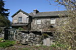
Anne Tyson's Cottage
Hawkshead , South LakelandHouse
17th century
18 May 1953 SD3516998175 54°22′30″N 2°59′58″W / 54.374934°N 2.99952°W / 54.374934; -2.99952 (Anne Tyson's Cottage ) 1338191 Anne Tyson's Cottage
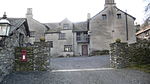
Hawkshead Courthouse
Hawkshead, South Lakeland
Court House
13th century
25 March 1970 SD3504298813 54°22′50″N 3°00′06″W / 54.380651°N 3.001614°W / 54.380651; -3.001614 (Hawkshead Courthouse ) 1335777 Hawkshead Courthouse
Hawkshead Grammar School
Hawkshead, South Lakeland
School
1675
18 May 1953 SD3523698038 54°22′25″N 2°59′54″W / 54.373712°N 2.998459°W / 54.373712; -2.998459 (Hawkshead Grammar School ) 1087232 Hawkshead Grammar School
Hawkshead Old Hall
Hawkshead, South Lakeland
House
17th century
18 May 1953 SD3492798781 54°22′49″N 3°00′12″W / 54.380348°N 3.003378°W / 54.380348; -3.003378 (Hawkshead Old Hall ) 1087223 Upload Photo
Stables and attached Barn to South West of Sizergh Castle
Helsington , South LakelandHouse
1983
22 November 1983 SD4979387838 54°17′01″N 2°46′22″W / 54.283697°N 2.772679°W / 54.283697; -2.772679 (Stables and attached Barn to South West of Sizergh Castle ) 1136853 Stables and attached Barn to South West of Sizergh Castle
Barn to East of Park House Farmhouse with Attached Shippons to North and East
Heversham , South LakelandHorse Engine House
19th century
21 November 1952 SD4951982640 54°14′13″N 2°46′34″W / 54.236958°N 2.776009°W / 54.236958; -2.776009 (Barn to East of Park House Farmhouse with Attached Shippons to North and East ) 1086563 Upload Photo
Church of St Peter
Heversham, South Lakeland
Cross
Celtic
12 February 1962 SD4960083390 54°14′37″N 2°46′30″W / 54.243706°N 2.774893°W / 54.243706; -2.774893 (Church of St Peter ) 1086557 Church of St Peter
Heversham Hall
Heversham, South Lakeland
House
14th century
21 November 1952 SD4938283241 54°14′32″N 2°46′42″W / 54.242345°N 2.778213°W / 54.242345; -2.778213 (Heversham Hall ) 1137245 Upload Photo
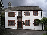
Hincaster Hall
Hincaster , South LakelandFarmhouse
Late 16th century
21 November 1952 SD5063684838 54°15′25″N 2°45′33″W / 54.256819°N 2.759236°W / 54.256819; -2.759236 (Hincaster Hall ) 1086572 Hincaster Hall
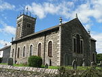
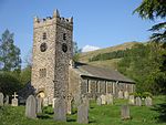
Church of St Anne
Hugill , South LakelandParish Church
1743
12 February 1962 SD4460898633 54°22′49″N 2°51′16″W / 54.380165°N 2.85432°W / 54.380165; -2.85432 (Church of St Anne ) 1281325 Church of St Anne
Reston Hall
Reston, Hugill, South Lakeland
House
1743
12 February 1962 SD4575898573 54°22′47″N 2°50′12″W / 54.37975°N 2.836606°W / 54.37975; -2.836606 (Reston Hall ) 1204237 Upload Photo
Bridge carrying Drive to North East of Helsington Laithes Farmhouse
Kendal , South LakelandRoad Bridge
18th century
30 January 1985 SD5067190736 54°18′35″N 2°45′35″W / 54.309825°N 2.759674°W / 54.309825; -2.759674 (Bridge carrying Drive to North East of Helsington Laithes Farmhouse ) 1137459 Upload Photo
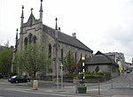
Church of Holy Trinity and St George
Kendal, South Lakeland
Roman Catholic Church
1835
30 January 1985 SD5173592761 54°19′41″N 2°44′37″W / 54.328124°N 2.74365°W / 54.328124; -2.74365 (Church of Holy Trinity and St George ) 1318999 Church of Holy Trinity and St George
Collinfield Farmhouse
Kendal, South Lakeland
Farmhouse
Mid/Late 16th century
24 April 1951 SD5108591401 54°18′57″N 2°45′12″W / 54.315841°N 2.75342°W / 54.315841; -2.75342 (Collinfield Farmhouse ) 1312242 Upload Photo
Entrance to Yard 41
Kendal, South Lakeland
Gate
C20
14 April 1969 SD5160392780 54°19′42″N 2°44′44″W / 54.328282°N 2.745683°W / 54.328282; -2.745683 (Entrance to Yard 41 ) 1318997 Upload Photo
Friends Meeting House
Kendal, South Lakeland
Classroom
1934
24 April 1951 SD5177892808 54°19′43″N 2°44′35″W / 54.328551°N 2.742997°W / 54.328551; -2.742997 (Friends Meeting House ) 1319001 Friends Meeting House
Gilthwaiterigg
Kendal, South Lakeland
House
Later
30 January 1985 SD5208395323 54°21′04″N 2°44′19″W / 54.35118°N 2.738712°W / 54.35118; -2.738712 (Gilthwaiterigg ) 1145706 Upload Photo
Helsington Laithes Farmhouse
Kendal, South Lakeland
Manor House
Late C15/Early 16th century
24 April 1951 SD5062290700 54°18′34″N 2°45′38″W / 54.309497°N 2.760421°W / 54.309497; -2.760421 (Helsington Laithes Farmhouse ) 1145728 Upload Photo
Highgate Hotel
Kendal, South Lakeland
House
1769
24 April 1951 SD5147492327 54°19′27″N 2°44′51″W / 54.324199°N 2.747592°W / 54.324199; -2.747592 (Highgate Hotel ) 1319004 Highgate Hotel
No.7 (includes 9 and 11)
Kendal, South Lakeland
Town House
16th century
14 April 1969 SD5166592756 54°19′41″N 2°44′41″W / 54.328073°N 2.744726°W / 54.328073; -2.744726 (No.7 (includes 9 and 11) ) 1145672 Upload Photo
Nos 13, 15, 17 17a and 19
Kendal, South Lakeland
House
1688
24 April 1951 SD5151292754 54°19′41″N 2°44′49″W / 54.32804°N 2.747078°W / 54.32804; -2.747078 (Nos 13, 15, 17 17a and 19 ) 1145674 Upload Photo
Numbers 26 and 28 with Entrance to Yard 24
Kendal, South Lakeland
Shop
c. 1828 14 April 1969 SD5147092671 54°19′38″N 2°44′52″W / 54.32729°N 2.74771°W / 54.32729; -2.74771 (Numbers 26 and 28 with Entrance to Yard 24 ) 1145715 Numbers 26 and 28 with Entrance to Yard 24
Shop and adjoining Public Convenience
Kendal, South Lakeland
Town House
Late 17th century
18 February 1992 SD5158792765 54°19′41″N 2°44′45″W / 54.328146°N 2.745926°W / 54.328146; -2.745926 (Shop and adjoining Public Convenience ) 1254250 Upload Photo
Wattsfield Farmhouse and Cottage
Kendal, South Lakeland
House
17th century
24 April 1951 SD5168691291 54°18′54″N 2°44′39″W / 54.31491°N 2.744165°W / 54.31491; -2.744165 (Wattsfield Farmhouse and Cottage ) 1145641 Upload Photo
Kentmere Hall and attached Barn
Hodgson Brow, Kentmere , South Lakeland
Farmhouse
Late 14th century or early 15th century
21 November 1952 NY4510004236 54°25′50″N 2°50′52″W / 54.430568°N 2.847784°W / 54.430568; -2.847784 (Kentmere Hall and attached Barn ) 1086547 Kentmere Hall and attached Barn
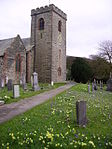
Church of All Saints
Killington , South LakelandChurch
14th century
12 February 1962 SD6132288992 54°17′42″N 2°35′45″W / 54.295072°N 2.595756°W / 54.295072; -2.595756 (Church of All Saints ) 1335928 Church of All Saints
Hallbeck
Hallbeck, Killington, South Lakeland
House
1684
12 February 1962 SD6210288411 54°17′24″N 2°35′01″W / 54.289909°N 2.583699°W / 54.289909; -2.583699 (Hallbeck ) 1086885 Upload Photo
Ashlack Hall and Outbuildings
Kirkby Ireleth, South Lakeland
House
16th century
18 May 1953 SD2467785516 54°15′35″N 3°09′28″W / 54.259743°N 3.157802°W / 54.259743; -3.157802 (Ashlack Hall and Outbuildings ) 1086791 Ashlack Hall and Outbuildings
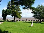
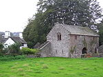
Church of St Cuthbert
Beck Side, Kirkby Ireleth , South Lakeland
Church
12th century
25 March 1970 SD2336982234 54°13′48″N 3°10′37″W / 54.230059°N 3.177037°W / 54.230059; -3.177037 (Church of St Cuthbert ) 1086792 Church of St Cuthbert
Church Brow Cottage
Kirkby Lonsdale, South Lakeland
House
Early 19th century
22 March 1983 SD6115978892 54°12′15″N 2°35′49″W / 54.204293°N 2.596948°W / 54.204293; -2.596948 (Church Brow Cottage ) 1311544 Upload Photo
High Biggins Old Hall
Kirkby Lonsdale , South LakelandManor House
15th century
12 February 1962 SD6012078244 54°11′54″N 2°36′46″W / 54.19839°N 2.612789°W / 54.19839; -2.612789 (High Biggins Old Hall ) 1145801 Upload Photo
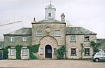
Tearnside Hall and attached Stable and Barn
Kirkby Lonsdale, South Lakeland
Farmhouse
1686
21 November 1952 SD5882779397 54°12′31″N 2°37′58″W / 54.208649°N 2.632765°W / 54.208649; -2.632765 (Tearnside Hall and attached Stable and Barn ) 1145782 Upload Photo
Underley Hall School
Kirkby Lonsdale, South Lakeland
House
1825-8
5 March 1982 SD6150480135 54°12′56″N 2°35′31″W / 54.21549°N 2.591819°W / 54.21549; -2.591819 (Underley Hall School ) 1311597 Underley Hall School
Barn adjacent to the Bield
Langdales, Lakes , South Lakeland
House
17th century
12 January 1967 NY3115803655 54°25′25″N 3°03′45″W / 54.423648°N 3.062527°W / 54.423648; -3.062527 (Barn adjacent to the Bield ) 1271944 Upload Photo
Barn at Town End
Troutbeck Village, Lakes, South LakelandBarn
1666
12 January 1967 NY4072802234 54°24′44″N 2°54′53″W / 54.412086°N 2.914768°W / 54.412086; -2.914768 (Barn at Town End ) 1245541 Barn at Town End
Barns, Stables etc to North and East of Rydal Hall
Rydal , Lakes, South LakelandBarn
15 March 1974 NY3662606377 54°26′56″N 2°58′44″W / 54.448819°N 2.978849°W / 54.448819; -2.978849 (Barns, Stables etc to North and East of Rydal Hall ) 1245500 Barns, Stables etc to North and East of Rydal Hall
Bridge over Rydal Beck in Grounds of Rydal Hall
Rydal, Lakes, South Lakeland
Arch Bridge
Late 17th century
15 March 1974 NY3665706319 54°26′54″N 2°58′42″W / 54.448301°N 2.978359°W / 54.448301; -2.978359 (Bridge over Rydal Beck in Grounds of Rydal Hall ) 1245408 Bridge over Rydal Beck in Grounds of Rydal Hall
Buildings attached to Walthwaite
Langdales, Lakes, South Lakeland
House
17th century
12 January 1967 NY3238205568 54°26′28″N 3°02′39″W / 54.441001°N 3.044102°W / 54.441001; -3.044102 (Buildings attached to Walthwaite ) 1245269 Upload Photo
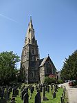
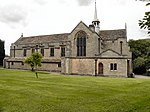
Church of St Mary
Ambleside , Lakes, South LakelandChurch
1850-1854
12 January 1967 NY3739604360 54°25′51″N 2°58′00″W / 54.43079°N 2.966549°W / 54.43079; -2.966549 (Church of St Mary ) 1244784 Church of St Mary
Church of St Mary
Rydal , Lakes, South LakelandChurch
1842
12 January 1967 NY3643606214 54°26′50″N 2°58′54″W / 54.44733°N 2.981744°W / 54.44733; -2.981744 (Church of St Mary ) 1245403 Church of St Mary
Fox How
Lakes, South Lakeland
House
1834
15 March 1974 NY3652104950 54°26′10″N 2°58′49″W / 54.435983°N 2.980162°W / 54.435983; -2.980162 (Fox How ) 1271870 Upload Photo
Game Larder in Grounds of Rydal Hall
Rydal, Lakes, South Lakeland
Game Larder
15 March 1974 NY3658506422 54°26′57″N 2°58′46″W / 54.449218°N 2.979491°W / 54.449218; -2.979491 (Game Larder in Grounds of Rydal Hall ) 1245409 Game Larder in Grounds of Rydal Hall
Gatehouse at Croft Hotel
Clappersgate , Lakes, South LakelandGarage
16th century
12 January 1967 NY3671603581 54°25′25″N 2°58′37″W / 54.423706°N 2.976863°W / 54.423706; -2.976863 (Gatehouse at Croft Hotel ) 1245480 Gatehouse at Croft Hotel
Goodybridge House and attached Barn to North East
Lakes, South Lakeland
House
17th century
15 March 1974 NY3329608167 54°27′52″N 3°01′50″W / 54.464476°N 3.030599°W / 54.464476; -3.030599 (Goodybridge House and attached Barn to North East ) 1272006 Goodybridge House and attached Barn to North East
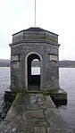
Ice House in Grounds of Rydal Hall
Rydal, Lakes, South Lakeland
Icehouse
15 March 1974 NY3662806573 54°27′02″N 2°58′44″W / 54.45058°N 2.97886°W / 54.45058; -2.97886 (Ice House in Grounds of Rydal Hall ) 1245501 Upload Photo
Jesus Church
Troutbeck , Lakes, South LakelandBell Tower
1736
12 January 1967 NY4130802796 54°25′02″N 2°54′21″W / 54.417204°N 2.905944°W / 54.417204; -2.905944 (Jesus Church ) 1271827 Jesus Church
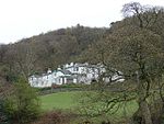
Rydal Hall
Lakes, South Lakeland
House
16th century
12 January 1967 NY3655306354 54°26′55″N 2°58′48″W / 54.448603°N 2.97997°W / 54.448603; -2.97997 (Rydal Hall ) 1245499 Rydal Hall
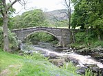
Slater's Bridge (that Part in the Lakes Urban District)
Langdales, Lakes, South Lakeland
Packhorse Bridge
17th century
12 January 1967 NY3120903010 54°25′04″N 3°03′42″W / 54.417859°N 3.061591°W / 54.417859; -3.061591 (Slater's Bridge (that Part in the Lakes Urban District) ) 1245295 Slater's Bridge (that Part in the Lakes Urban District)
Slater's Bridge (that Part in the Parish of Coniston)
Little Langdale, Lakes, South Lakeland
Packhorse Bridge
17th century
22 September 1987 NY3120903007 54°25′04″N 3°03′42″W / 54.417832°N 3.06159°W / 54.417832; -3.06159 (Slater's Bridge (that Part in the Parish of Coniston) ) 1119623 Slater's Bridge (that Part in the Parish of Coniston)
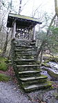
Summer House in Grounds of Rydal Hall
Rydal, Lakes, South Lakeland
Summerhouse
Late 17th century
15 March 1974 NY3664206334 54°26′54″N 2°58′43″W / 54.448434°N 2.978593°W / 54.448434; -2.978593 (Summer House in Grounds of Rydal Hall ) 1271834 Summer House in Grounds of Rydal Hall
Terraces to South of Rydal Hall
Rydal, Lakes, South Lakeland
Stepped Terrace
15 March 1974 NY3656106317 54°26′54″N 2°58′47″W / 54.448271°N 2.979838°W / 54.448271; -2.979838 (Terraces to South of Rydal Hall ) 1245407 Terraces to South of Rydal Hall
The Nab
Rydal, Lakes, South Lakeland
House
1702
12 January 1967 NY3549206399 54°26′56″N 2°59′47″W / 54.448873°N 2.996339°W / 54.448873; -2.996339 (The Nab ) 1271876 The Nab
Wood Farmhouse
Troutbeck, Lakes, South Lakeland
Farmhouse
17th century
15 March 1974 NY3941601559 54°24′21″N 2°56′05″W / 54.405866°N 2.934843°W / 54.405866; -2.934843 (Wood Farmhouse ) 1245538 Upload Photo
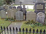
Wordsworth Group of Graves in Churchyard of Church of St Oswald
Grasmere , Lakes, South LakelandGravestone
15 March 1974 NY3377107398 54°27′27″N 3°01′23″W / 54.457628°N 3.023099°W / 54.457628; -3.023099 (Wordsworth Group of Graves in Churchyard of Church of St Oswald ) 1272008 Wordsworth Group of Graves in Churchyard of Church of St Oswald
Nether Levens Farmhouse and attached Store to North
Levens , South LakelandFarmhouse
Early 16th century
21 November 1952 SD4882785119 54°15′33″N 2°47′13″W / 54.259167°N 2.787049°W / 54.259167; -2.787049 (Nether Levens Farmhouse and attached Store to North ) 1319030 Upload Photo
Old Stables about 50m North East of Levens Hall, Cottages attached to North West and South; and Gate Piers Attache
Levens, South Lakeland
House
Mid C20
21 November 1952 SD4958785150 54°15′34″N 2°46′31″W / 54.259521°N 2.775389°W / 54.259521; -2.775389 (Old Stables about 50m North East of Levens Hall, Cottages attached to North West and South; and Gate Piers Attache ) 1318992 Upload Photo
Priory Close House
Cartmel , Lower Allithwaite , South LakelandHouse
Possibly Medieval
25 March 1970 SD3792678796 54°12′04″N 2°57′11″W / 54.201139°N 2.953055°W / 54.201139; -2.953055 (Priory Close House ) 1348727 Priory Close House
Priory Gatehouse , Including East Bay of Gatehouse
Cartmel, Lower Allithwaite, South Lakeland
School
1624
25 March 1970 SD3782278787 54°12′04″N 2°57′17″W / 54.201045°N 2.954647°W / 54.201045; -2.954647 (Priory Gatehouse, Including East Bay of Gatehouse ) 1348693 Priory Gatehouse , Including East Bay of Gatehouse
Wraysholme Tower
Flookburgh , Lower Allithwaite, South LakelandFarmhouse
17th century
25 March 1970 SD3831875420 54°10′15″N 2°56′47″W / 54.170849°N 2.946354°W / 54.170849; -2.946354 (Wraysholme Tower ) 1100320 Wraysholme Tower
Canon Winder Hall
Flookburgh, Lower Holker, South Lakeland
Farmhouse
16th century
18 May 1953 SD3514774718 54°09′51″N 2°59′41″W / 54.164149°N 2.994768°W / 54.164149; -2.994768 (Canon Winder Hall ) 1335840 Canon Winder Hall
Cark Hall, North Cottage, South Cottage
Cark in Cartmel, Lower Holker, South LakelandHouse
1580
18 May 1953 SD3651676741 54°10′57″N 2°58′27″W / 54.1825°N 2.974232°W / 54.1825; -2.974232 (Cark Hall, North Cottage, South Cottage ) 1087146 Cark Hall, North Cottage, South Cottage
Church of St John Baptist
Flookburgh, Lower Holker, South Lakeland
Church
1777
25 March 1970 SD3654976019 54°10′34″N 2°58′25″W / 54.176016°N 2.973574°W / 54.176016; -2.973574 (Church of St John Baptist ) 1087115 Church of St John Baptist
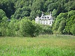
Holker Hall and Terrace Wall Approximately 70 Metres to Garden to South East
Holker, Lower Holker, South Lakeland
Apartment
1970
25 March 1970 SD3590977383 54°11′17″N 2°59′01″W / 54.188193°N 2.983668°W / 54.188193; -2.983668 (Holker Hall and Terrace Wall Approximately 70 Metres to Garden to South East ) 1335814 Holker Hall and Terrace Wall Approximately 70 Metres to Garden to South East
Manor House and Adjoining Outbuilding
Flookburgh, Lower Holker, South Lakeland
House
1686
25 March 1970 SD3679575837 54°10′28″N 2°58′11″W / 54.174411°N 2.969767°W / 54.174411; -2.969767 (Manor House and Adjoining Outbuilding ) 1335820 Upload Photo
Lowick Hall
Lowick , South LakelandHouse
Mid 18th century
25 March 1970 SD2858685956 54°15′51″N 3°05′52″W / 54.264258°N 3.097911°W / 54.264258; -3.097911 (Lowick Hall ) 1086795 Lowick Hall
Curtain Wall to South-west of Middleton Hall
Middleton , South LakelandPrivy House
Mid 15th century
12 February 1962 SD6268287426 54°16′52″N 2°34′29″W / 54.2811°N 2.574666°W / 54.2811; -2.574666 (Curtain Wall to South-west of Middleton Hall ) 1146448 Upload Photo
Curtain Wall to West and North West and Barn to North West of Middleton Hall
Middleton, South Lakeland
Curtain Wall
Mid 15th century
12 February 1962 SD6267687458 54°16′53″N 2°34′29″W / 54.281387°N 2.574762°W / 54.281387; -2.574762 (Curtain Wall to West and North West and Barn to North West of Middleton Hall ) 1086862 Upload Photo
Middleton Hall
Middleton, South Lakeland
Farmhouse
Late 14th century
21 November 1952 SD6269687441 54°16′52″N 2°34′28″W / 54.281236°N 2.574453°W / 54.281236; -2.574453 (Middleton Hall ) 1086861 Middleton Hall
Outbuilding adjoining North East angle of Middleton Hall and adjoining Wall
Middleton, South Lakeland
Farmhouse
Early to Mid 15th century
21 November 1952 SD6269787455 54°16′53″N 2°34′28″W / 54.281362°N 2.574439°W / 54.281362; -2.574439 (Outbuilding adjoining North East angle of Middleton Hall and adjoining Wall ) 1146424 Upload Photo
Roman Milestone approx. 74m to West of Road
Middleton, South Lakeland
Milestone
Roman
12 February 1962 SD6226385883 54°16′02″N 2°34′51″W / 54.267203°N 2.580906°W / 54.267203; -2.580906 (Roman Milestone approx. 74m to West of Road ) 1086866 Roman Milestone approx. 74m to West of Road
Church of St Mark
Natland , Natland, South LakelandParish Church
1909-1910
19 July 1984 SD5210789200 54°17′46″N 2°44′14″W / 54.296159°N 2.737358°W / 54.296159; -2.737358 (Church of St Mark ) 1137760 Church of St Mark
Blease Hall
Old Hutton and Holmescales , South LakelandHouse
c. 1600 21 November 1952 SD5492589167 54°17′46″N 2°41′39″W / 54.296119°N 2.694059°W / 54.296119; -2.694059 (Blease Hall ) 1312207 Blease Hall
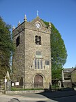
Tower of Chapel of St Margaret
Over Staveley , South LakelandTower
1388
12 February 1962 SD4713698176 54°22′35″N 2°48′55″W / 54.376328°N 2.815322°W / 54.376328; -2.815322 (Tower of Chapel of St Margaret ) 1086550 Tower of Chapel of St Margaret
Preston Patrick Hall
Preston Patrick , South LakelandHouse
15th century or early 16th century
21 November 1952 SD5443083748 54°14′51″N 2°42′03″W / 54.247377°N 2.700837°W / 54.247377; -2.700837 (Preston Patrick Hall ) 1312117 Preston Patrick Hall
Graythwaite Old Hall
Graythwaite, Satterthwaite , South Lakeland
House
16th century or 17th century
18 May 1953 SD3720290891 54°18′35″N 2°58′00″W / 54.309736°N 2.966691°W / 54.309736; -2.966691 (Graythwaite Old Hall ) 1087200 Graythwaite Old Hall
Abbot Holme Bridge
Dentdale, Sedbergh , South Lakeland
Road Bridge
Probably 17th century
14 June 1984 SD6488890827 54°18′43″N 2°32′28″W / 54.311821°N 2.541187°W / 54.311821; -2.541187 (Abbot Holme Bridge ) 1384064 Abbot Holme Bridge
Archer's Hall
Millthrop, Sedbergh, South Lakeland
Farmhouse
1681
16 March 1954 SD6585791111 54°18′52″N 2°31′35″W / 54.314439°N 2.526326°W / 54.314439; -2.526326 (Archer's Hall ) 1384200 Upload Photo
Chapel at Sedbergh School
Sedbergh Town, Sedbergh, South Lakeland
School
1897
14 June 1984 SD6579691770 54°19′13″N 2°31′38″W / 54.320358°N 2.527339°W / 54.320358; -2.527339 (Chapel at Sedbergh School ) 1384171 Chapel at Sedbergh School
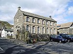
The Old Grammar School (now the School Library)
Sedbergh, South Lakeland
School
1954
16 March 1954 SD6577592030 54°19′22″N 2°31′40″W / 54.322693°N 2.527692°W / 54.322693; -2.527692 (The Old Grammar School (now the School Library) ) 1384071 The Old Grammar School (now the School Library)
Crook of Lune Bridge (that part in Grayrigg CP)
Sedbergh, South Lakeland
Bridge
17th century or 18th century
16 February 1963 SD6203396311 54°21′39″N 2°35′09″W / 54.360899°N 2.585767°W / 54.360899; -2.585767 (Crook of Lune Bridge (that part in Grayrigg CP) ) 1137785 Crook of Lune Bridge (that part in Grayrigg CP)
Crook of Lune Bridge (that Part in Sedbergh CP)
Howgill, Sedbergh, South Lakeland
Bridge
16th century or earlier
16 March 1954 SD6203396312 54°21′39″N 2°35′09″W / 54.360908°N 2.585767°W / 54.360908; -2.585767 (Crook of Lune Bridge (that Part in Sedbergh CP) ) 1384145 Crook of Lune Bridge (that Part in Sedbergh CP)
High Oaks
Marthwaite, Sedbergh, South Lakeland
Kitchen
19th century
16 March 1954 SD6270791076 54°18′50″N 2°34′29″W / 54.313904°N 2.574739°W / 54.313904; -2.574739 (High Oaks ) 1384164 Upload Photo
Hollin Hill Farmhouse
Soolbank, Sedbergh, South Lakeland
Farmhouse
1712
14 June 1984 SD6745192880 54°19′50″N 2°30′07″W / 54.330441°N 2.502019°W / 54.330441; -2.502019 (Hollin Hill Farmhouse ) 1384082 Upload Photo
Mire House
Sedbergh, South Lakeland
Farmhouse
17th century
14 June 1984 SD6915194276 54°20′35″N 2°28′34″W / 54.343093°N 2.476024°W / 54.343093; -2.476024 (Mire House ) 1384111 Upload Photo
Stone Hall
Soolbank, Sedbergh, South Lakeland
Farmhouse
1695
16 March 1954 SD6717292786 54°19′46″N 2°30′23″W / 54.329579°N 2.506299°W / 54.329579; -2.506299 (Stone Hall ) 1384219 Upload Photo
The Hill
Marthwaite, Sedbergh, South Lakeland
House
Altered post 1712
16 March 1954 SD6258690550 54°18′33″N 2°34′36″W / 54.309168°N 2.576533°W / 54.309168; -2.576533 (The Hill ) 1384166 Upload Photo
Thorns Hall and attached Stable Wing to Rear
Soolbank, Sedbergh, South Lakeland
House
Probably early to mid 17th century
16 March 1954 SD6636892158 54°19′26″N 2°31′07″W / 54.323883°N 2.51859°W / 54.323883; -2.51859 (Thorns Hall and attached Stable Wing to Rear ) 1384176 Upload Photo
War Memorial Cloister at Sedbergh School
Sedbergh , South LakelandWar Memorial
1924
14 June 1984 SD6552891912 54°19′18″N 2°31′53″W / 54.321616°N 2.531476°W / 54.321616; -2.531476 (War Memorial Cloister at Sedbergh School ) 1384218 War Memorial Cloister at Sedbergh School
Barn End, Bull Close, Bull Close Cottage
Skelwith Fold, Skelwith, South Lakeland
House
Late 17th century
25 March 1970 NY3473402469 54°24′48″N 3°00′26″W / 54.413463°N 3.00716°W / 54.413463; -3.00716 (Barn End, Bull Close, Bull Close Cottage ) 1121997 Upload Photo
Newby Bridge
Newby Bridge, Staveley-in-Cartmel , South Lakeland
Bridge
Before 17th century
25 March 1970 SD3690186359 54°16′08″N 2°58′13″W / 54.268975°N 2.970359°W / 54.268975; -2.970359 (Newby Bridge ) 1225523 Newby Bridge
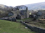
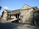
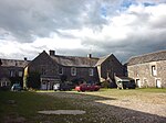
Burneside Hall
Strickland Roger , South LakelandHouse
Later than 14th century
21 November 1952 SD5099195934 54°21′24″N 2°45′20″W / 54.356567°N 2.755612°W / 54.356567; -2.755612 (Burneside Hall ) 1289216 Burneside Hall
Hoathwaite Farmhouse and Outbuildings
Torver , South LakelandFarmhouse
Late 17th century
22 September 1987 SD2959694927 54°20′42″N 3°05′04″W / 54.345008°N 3.084526°W / 54.345008; -3.084526 (Hoathwaite Farmhouse and Outbuildings ) 1087210 Upload Photo
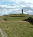
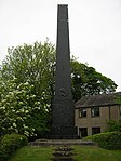
Barrow Monument
Ulverston , South LakelandCommemorative Monument
1850
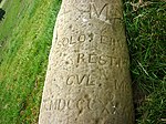
2 March 1950 SD2946079072 54°12′09″N 3°04′58″W / 54.202522°N 3.082875°W / 54.202522; -3.082875 (Barrow Monument ) 1375003 Barrow Monument
Church of St Mary
Ulverston, South Lakeland
Parish Church
16th century
2 March 1950 SD2889978685 54°11′56″N 3°05′29″W / 54.198967°N 3.091381°W / 54.198967; -3.091381 (Church of St Mary ) 1374977 Church of St Mary
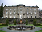
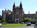
Conishead Priory
Ulverston, South Lakeland
House
Earlier
2 March 1950 SD3040375826 54°10′25″N 3°04′04″W / 54.173484°N 3.067669°W / 54.173484; -3.067669 (Conishead Priory ) 1270176 Conishead Priory
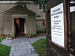
Friends Meeting House
Ulverston, South Lakeland
Meeting Hall
1996
2 March 1950 SD2837876875 54°10′57″N 3°05′56″W / 54.182631°N 3.098934°W / 54.182631; -3.098934 (Friends Meeting House ) 1270207 Friends Meeting House
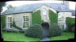
Swarthmoor Hall
Ulverston, South Lakeland
House
Early 17th century
2 March 1950 SD2818677293 54°11′11″N 3°06′07″W / 54.18636°N 3.101976°W / 54.18636; -3.101976 (Swarthmoor Hall ) 1270174 Swarthmoor Hall
Barrow Wife
Upper Allithwaite, South Lakeland
House
1987
25 March 1970 SD4068284824 54°15′20″N 2°54′43″W / 54.255634°N 2.912007°W / 54.255634; -2.912007 (Barrow Wife ) 1225720 Barrow Wife
Monument to John Wilkinson approx. 17m north of Junction with Dixon Wood Close
Lindale , Upper Allithwaite, South LakelandCommemorative Monument
1808
25 March 1970 SD4184280331 54°12′55″N 2°53′36″W / 54.215393°N 2.893331°W / 54.215393; -2.893331 (Monument to John Wilkinson approx. 17m north of Junction with Dixon Wood Close ) 1266208 Monument to John Wilkinson approx. 17m north of Junction with Dixon Wood Close
Selside Hall and attached Outbuilding
Whitwell and Selside, South Lakeland
House
Late 14th century
21 November 1952 SD5345999043 54°23′05″N 2°43′05″W / 54.384737°N 2.718128°W / 54.384737; -2.718128 (Selside Hall and attached Outbuilding ) 1311671 Upload Photo
Causeway Farmhouse
Windermere, South Lakeland
Farmhouse
Mid 17th century
8 May 1950 NY4154600045 54°23′33″N 2°54′06″W / 54.392511°N 2.901735°W / 54.392511; -2.901735 (Causeway Farmhouse ) 1124676 Upload Photo
Far Orest Old Farm Cottage
Troutbeck, Windermere, South Lakeland
House
17th century
20 February 1982 NY4128900786 54°23′57″N 2°54′21″W / 54.39914°N 2.905839°W / 54.39914; -2.905839 (Far Orest Old Farm Cottage ) 1124758 Upload Photo
Far Orrest Old Farm Cottage
Troutbeck, Windermere, South Lakeland
House
17th century porch / open store
20 February 1982 NY4128000785 54°23′57″N 2°54′22″W / 54.39913°N 2.905977°W / 54.39913; -2.905977 (Far Orrest Old Farm Cottage ) 1255499 Upload Photo
Ferry Cottage, Low Miller Ground
Windermere , South LakelandHouse
17th century
8 May 1950 SD4026098841 54°22′54″N 2°55′17″W / 54.381542°N 2.921294°W / 54.381542; -2.921294 (Ferry Cottage, Low Miller Ground ) 1124747 Upload Photo
Helm Farmhouse, and Helm Farm Cottage, with attached Barn
Bowness on Windermere , Windermere, South LakelandFarmhouse
1692
8 May 1950 SD4128796987 54°21′54″N 2°54′18″W / 54.365002°N 2.905118°W / 54.365002; -2.905118 (Helm Farmhouse, and Helm Farm Cottage, with attached Barn ) 1124691 Upload Photo
High Miller Ground
Windermere, South Lakeland
House
18th century
8 May 1950 SD4038998858 54°22′54″N 2°55′10″W / 54.38171°N 2.919312°W / 54.38171; -2.919312 (High Miller Ground ) 1203436 Upload Photo
Longmire
Troutbeck, Windermere, South Lakeland
House
17th century
8 May 1950 NY4140401935 54°24′34″N 2°54′15″W / 54.409478°N 2.904295°W / 54.409478; -2.904295 (Longmire ) 1124753 Upload Photo
Near Orrest Farmhouse
Windermere, South Lakeland
Farmhouse
16th century
8 May 1950 NY4187500202 54°23′38″N 2°53′48″W / 54.393959°N 2.896699°W / 54.393959; -2.896699 (Near Orrest Farmhouse ) 1124677 Upload Photo
Rayrigg Hall Farmhouse
Windermere, South Lakeland
Farmhouse
Early 18th century
8 May 1950 SD4027498095 54°22′29″N 2°55′15″W / 54.37484°N 2.920929°W / 54.37484; -2.920929 (Rayrigg Hall Farmhouse ) 1332567 Upload Photo
Rayrigg Hall
Windermere, South Lakeland
House
Early 18th century
8 May 1950 SD4028898088 54°22′29″N 2°55′15″W / 54.374779°N 2.920712°W / 54.374779; -2.920712 (Rayrigg Hall ) 1124746 Upload Photo
Rectory (St Martin's)
Bowness-on-Windermere , Windermere, South LakelandVicarage
16th century
8 May 1950 SD3990896210 54°21′28″N 2°55′34″W / 54.357859°N 2.926181°W / 54.357859; -2.926181 (Rectory (St Martin's) ) 1124688 Rectory (St Martin's)
Storrs Hall
Bowness on Windermere, Windermere, South Lakeland
Country House
18th century
8 May 1950 SD3926294135 54°20′21″N 2°56′09″W / 54.339136°N 2.935696°W / 54.339136; -2.935696 (Storrs Hall ) 1332564 Storrs Hall
Storrs Temple
Storrs Hall, Windermere, South Lakeland
Garden House
1804
8 May 1950 SD3904594103 54°20′20″N 2°56′20″W / 54.338823°N 2.939027°W / 54.338823; -2.939027 (Storrs Temple ) 1124742 Storrs Temple
Church of St Paul
Witherslack, South Lakeland
Church
1664-1671
12 February 1962 SD4317484191 54°15′01″N 2°52′25″W / 54.250229°N 2.873641°W / 54.250229; -2.873641 (Church of St Paul ) 1087094 Church of St Paul