50:. It covers an area of 4,300 km (1,660 sq mi), making it one of the largest banks of the world, has general depths of 60 to 80 metres (197–262 ft), and a largely sandy bottom. Two reefs mark the shallowest spots of the bank, but they are still submerged at low tide.
20:
203:
had been proved by French missions in the 1970s, and the information passed to hydrographic services around the world, but it had remained in the World Vector
Shoreline Database. In 2012 Australian scientists again proved the island does not exist.
60:, is a submarine feature shown on some maps in that area. The Lansdowne Bank area marked is far larger than Fairway Plateau, but there are smaller, unnamed plateaus nearby. The Lansdowne Bank area, shown at the northeastern end of
112:
is doubtful. Nereus Reef has the least depth of the bank, with 3.7 metres (12 ft). A shoal with a depth of 16 metres (52 ft) is 14 miles (23 km) west-northwest of Nereus Reef.
392:
417:
221:
147:
407:
75:
277:
382:
372:
377:
296:
196:
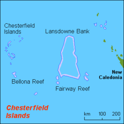
136:(south of the Chesterfield Islands) and New Caledonia. Fairway Reef is 3.2 kilometres (2.0 mi) long, about 4 to 5
343:
264:
412:
43:
285:(8 ed.). Bethesda, Maryland: National Geospatial Intelligence Agency (NGA). 2004. p. 135.
121:
120:
The southeastern end of
Lansdowne Bank is marked by Fairway Reef, thus named from its lying in the
19:
386:
199:
in northern
Lansdowne Bank, but did not show an image for it. The non-existence of this
200:
61:
35:
279:
Publication 127: Sailing
Directions (Enroute): East Coast of Australia and New Zealand
401:
213:
133:
129:
39:
317:
192:
236:
223:
163:
149:
91:
77:
125:
72:
Nereus Reef is at the northern end of
Lansdowne Bank. Its given position of
64:, is separated from New Caledonia by New Caledonia Basin and Fairway Basin.
47:
137:
141:
18:
184:. According to some sources, Fairway Reef dries at low tide.
297:"Reefbase: A Global Information System for Coral Reefs"
195:
and other internet maps showed a large landmass named
318:"South Pacific Sandy Island 'proven not to exist'"
8:
257:
7:
418:Undersea banks of the Pacific Ocean
344:"The Pacific island that never was"
265:Le parc naturel de la mer de Corail
38:located between the main island of
14:
389: (archived December 23, 2010)
46:, in the easternmost part of the
16:Submerged bank near New Caledonia
393:Part of Nautical Chart n° 6670
1:
140:(7.3 to 9.1 metres) deep, of
23:Lansdowne Bank, centre of map
434:
408:Landforms of New Caledonia
299:. WorldFish. April 2013
144:bottom, and located at
164:21.00417°S 161.75250°E
24:
132:, midway between the
22:
188:Sandy Island Mystery
169:-21.00417; 161.75250
44:Chesterfield Islands
233: /
159: /
87: /
30:, sometimes called
350:. 22 November 2012
324:. 22 November 2012
237:20.583°S 160.500°E
92:20.117°S 160.467°E
34:, is an extensive
25:
425:
360:
359:
357:
355:
340:
334:
333:
331:
329:
314:
308:
307:
305:
304:
293:
287:
286:
284:
274:
268:
262:
248:
247:
245:
244:
243:
242:-20.583; 160.500
238:
234:
231:
230:
229:
226:
183:
182:
180:
179:
178:
176:
171:
170:
165:
160:
157:
156:
155:
152:
111:
110:
108:
107:
106:
104:
99:
98:
97:-20.117; 160.467
93:
88:
85:
84:
83:
80:
433:
432:
428:
427:
426:
424:
423:
422:
398:
397:
387:Wayback Machine
369:
364:
363:
353:
351:
342:
341:
337:
327:
325:
316:
315:
311:
302:
300:
295:
294:
290:
282:
276:
275:
271:
263:
259:
254:
241:
239:
235:
232:
227:
224:
222:
220:
219:
210:
190:
174:
172:
168:
166:
162:
161:
158:
153:
150:
148:
146:
145:
118:
102:
100:
96:
94:
90:
89:
86:
81:
78:
76:
74:
73:
70:
58:Fairway Plateau
32:Landsdowne Bank
17:
12:
11:
5:
431:
429:
421:
420:
415:
410:
400:
399:
396:
395:
390:
380:
375:
368:
367:External links
365:
362:
361:
335:
309:
288:
269:
256:
255:
253:
250:
217:
216:
209:
206:
201:phantom island
189:
186:
117:
114:
69:
66:
62:Lord Howe Rise
56:, also called
36:submerged bank
28:Lansdowne Bank
15:
13:
10:
9:
6:
4:
3:
2:
430:
419:
416:
414:
411:
409:
406:
405:
403:
394:
391:
388:
384:
381:
379:
376:
374:
371:
370:
366:
349:
345:
339:
336:
323:
319:
313:
310:
298:
292:
289:
281:
280:
273:
270:
266:
261:
258:
251:
249:
246:
215:
214:List of reefs
212:
211:
207:
205:
202:
198:
194:
187:
185:
181:
143:
139:
135:
134:Bellona Reefs
131:
130:New Caledonia
127:
123:
115:
113:
109:
67:
65:
63:
59:
55:
54:Fairway Ridge
51:
49:
45:
41:
40:New Caledonia
37:
33:
29:
21:
383:Fairway Reef
352:. Retrieved
348:The Guardian
347:
338:
326:. Retrieved
321:
312:
301:. Retrieved
291:
278:
272:
260:
218:
197:Sandy Island
191:
175:Fairway Reef
119:
116:Fairway Reef
71:
57:
53:
52:
31:
27:
26:
413:Coral reefs
354:22 November
328:22 November
240: /
193:Google Maps
167: /
154:161°45′09″E
103:Nereus Reef
95: /
68:Nereus Reef
402:Categories
303:2013-04-19
252:References
173: (
151:21°00′15″S
101: (
126:Australia
48:Coral Sea
322:BBC News
228:160°30′E
208:See also
124:between
82:160°28′E
42:and the
385:at the
378:Geology
373:Geology
267:, p. 26
225:20°35′S
138:fathoms
122:fairway
79:20°07′S
283:(PDF)
142:coral
356:2012
330:2012
128:and
404::
346:.
320:.
358:.
332:.
306:.
177:)
105:)
Text is available under the Creative Commons Attribution-ShareAlike License. Additional terms may apply.