524:
44:
228:
31:
239:
51:
223:
In 2002/03, the dam crest was raised 9.8 feet (3 m) as the original height would have been overtopped during the
Probable Maximum Flood (PMF). This was part of a £6.5 million scheme to make Swinsty, Fewston and Lindley Wood reservoirs meet improved flood standards. The reservoir keeper's
209:
at the site and within a year she resolved to move to the camp. She was joined in her work by the
Reverend Lewis Moule Evans and together they founded was known as the "Navvies Mission".
405:
699:
235:
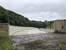
During 2019/20, the spillway was relined, and the side walls were raised in a £5 million project to ensure the embankment dam was protected from erosion.
224:
house at the dam was originally planned to be demolished during this work, but was built into the new, higher crest as bats were found to be living there.
86:
43:
523:
704:
398:
623:
302:
261:
364:
220:. While the three higher reservoirs provide water to the city of Leeds, Lindley Wood provides compensation flows to the Washburn.
391:
267:
205:
was moved by the living conditions of the workers and their families who were camped here building this reservoir. She opened a
349:
498:
673:
653:
508:
433:
216:
10 L; 900,000,000 US gal). It was the first of a chain of four reservoirs built along the
678:
483:
144:
668:
618:
513:
503:
488:
458:
297:
Lesser
Railways of the Yorkshire Dales and the Dam Builders in the Age of Steam by Harold D Bowtell,
375:
575:
570:
550:
545:
478:
227:
648:
628:
613:
565:
555:
468:
463:
443:
130:
595:
585:
493:
453:
438:
298:
202:
663:
658:
633:
560:
448:
428:
272:
638:
590:
540:
532:
420:
353:
318:
605:
217:
174:
158:
151:
137:
30:
238:
693:
262:"Garnett [née Hart], Elizabeth (1839–1921), missionary to navvies and author"
206:
118:
346:
643:
580:
231:
The upgraded spillway, pictured in July 2020, following completion of safety works.
284:
276:
101:
88:
182:
123:
72:
383:
198:
186:
131:
145:
237:
226:
178:
387:
319:"The Washburn Valley Reservoirs – Spillway Improvements"
212:
The capacity is about 750,000,000 imperial gallons (3.4
604:
531:
419:
365:£5m safety works at historic Lindley Wood reservoir
157:
143:
129:
117:
78:
68:
23:
260:
312:
310:
79:
347:Washburn Valley Reservoir Safety | Water | Arup
50:
399:
8:
271:(online ed.). Oxford University Press.
242:The spillway in full flow, pictured in 2008.
406:
392:
384:
20:
376:2019 Annual Review Mott MacDonald Bentley
317:Claydon, J R; Knott, D L; Carter, I C.
268:Oxford Dictionary of National Biography
252:
201:between 1869 and 1876. In about 1872
16:Reservoir in North Yorkshire, England
7:
700:Drinking water reservoirs in England
14:
522:
49:
42:
29:
1:
705:Reservoirs in North Yorkshire
67:
285:UK public library membership
197:The reservoir was built by
721:
520:
37:
28:
414:Reservoirs in Yorkshire
277:10.1093/ref:odnb/50747
243:
232:
171:Lindley Wood Reservoir
57:Lindley Wood Reservoir
24:Lindley Wood Reservoir
241:
230:
102:53.93889°N 1.67444°W
98: /
352:2009-03-27 at the
244:
233:
173:is located in the
107:53.93889; -1.67444
687:
686:
283:(Subscription or
203:Elizabeth Garnett
168:
167:
712:
526:
499:Thornton Steward
408:
401:
394:
385:
378:
373:
367:
362:
356:
344:
338:
337:
335:
333:
323:
314:
305:
295:
289:
288:
280:
264:
257:
215:
177:valley north of
147:
146:Primary outflows
133:
113:
112:
110:
109:
108:
103:
99:
96:
95:
94:
91:
81:
53:
52:
46:
33:
21:
720:
719:
715:
714:
713:
711:
710:
709:
690:
689:
688:
683:
600:
533:South Yorkshire
527:
518:
421:North Yorkshire
415:
412:
382:
381:
374:
370:
363:
359:
354:Wayback Machine
345:
341:
331:
329:
326:britishdams.org
321:
316:
315:
308:
296:
292:
282:
259:
258:
254:
249:
213:
195:
161: countries
132:Primary inflows
106:
104:
100:
97:
92:
89:
87:
85:
84:
64:
63:
62:
61:
60:
59:
58:
54:
17:
12:
11:
5:
718:
716:
708:
707:
702:
692:
691:
685:
684:
682:
681:
676:
671:
666:
661:
656:
651:
646:
641:
636:
631:
626:
621:
616:
610:
608:
606:West Yorkshire
602:
601:
599:
598:
593:
588:
583:
578:
573:
568:
563:
558:
553:
548:
543:
537:
535:
529:
528:
521:
519:
517:
516:
511:
506:
501:
496:
491:
486:
481:
476:
471:
466:
461:
456:
451:
446:
441:
436:
431:
425:
423:
417:
416:
413:
411:
410:
403:
396:
388:
380:
379:
368:
357:
339:
306:
290:
251:
250:
248:
245:
218:River Washburn
194:
191:
166:
165:
164:United Kingdom
162:
155:
154:
152:River Washburn
149:
141:
140:
138:River Washburn
135:
127:
126:
121:
115:
114:
82:
76:
75:
70:
66:
65:
56:
55:
48:
47:
41:
40:
39:
38:
35:
34:
26:
25:
15:
13:
10:
9:
6:
4:
3:
2:
717:
706:
703:
701:
698:
697:
695:
680:
677:
675:
672:
670:
667:
665:
662:
660:
657:
655:
652:
650:
647:
645:
642:
640:
637:
635:
632:
630:
627:
625:
622:
620:
617:
615:
612:
611:
609:
607:
603:
597:
594:
592:
589:
587:
584:
582:
579:
577:
574:
572:
569:
567:
564:
562:
559:
557:
554:
552:
549:
547:
544:
542:
539:
538:
536:
534:
530:
525:
515:
512:
510:
507:
505:
502:
500:
497:
495:
492:
490:
487:
485:
482:
480:
477:
475:
472:
470:
467:
465:
462:
460:
457:
455:
452:
450:
447:
445:
442:
440:
437:
435:
432:
430:
427:
426:
424:
422:
418:
409:
404:
402:
397:
395:
390:
389:
386:
377:
372:
369:
366:
361:
358:
355:
351:
348:
343:
340:
327:
320:
313:
311:
307:
304:
303:1-871980-09-7
300:
294:
291:
286:
278:
274:
270:
269:
263:
256:
253:
246:
240:
236:
229:
225:
221:
219:
210:
208:
207:Sunday School
204:
200:
192:
190:
188:
184:
180:
176:
172:
163:
160:
156:
153:
150:
148:
142:
139:
136:
134:
128:
125:
122:
120:
116:
111:
83:
77:
74:
71:
45:
36:
32:
27:
22:
19:
674:Walshaw Dean
654:Lower Laithe
644:Gaddings Dam
509:Upper Barden
474:Lindley Wood
473:
371:
360:
342:
330:. Retrieved
325:
293:
266:
255:
234:
222:
211:
196:
170:
169:
18:
679:Warley Moor
484:Scaling Dam
434:Beaver Dyke
332:21 December
328:. p. 1
105: /
80:Coordinates
694:Categories
669:Scammonden
619:Booth Wood
514:Winterburn
504:Thruscross
489:Scar House
459:Gouthwaite
287:required.)
247:References
90:53°56′20″N
624:Butterley
571:More Hall
551:Dale Dike
546:Broomhead
479:Roundhill
183:Yorkshire
124:Reservoir
93:1°40′28″W
73:Yorkshire
649:Hewenden
629:Deanhead
614:Baitings
576:Redmires
566:Langsett
556:Damflask
469:Leighton
464:Grimwith
444:Cod Beck
350:Archived
175:Washburn
69:Location
596:Winscar
586:Strines
581:Rivelin
494:Swinsty
454:Fewston
439:Chelker
199:navvies
193:History
187:England
664:Ryburn
659:Ponden
634:Digley
561:Howden
449:Embsay
429:Angram
301:
281:
639:Eccup
591:Ulley
541:Agden
322:(PDF)
179:Otley
159:Basin
334:2021
299:ISBN
119:Type
273:doi
181:in
696::
324:.
309:^
265:.
189:.
185:,
407:e
400:t
393:v
336:.
279:.
275::
214:×
Text is available under the Creative Commons Attribution-ShareAlike License. Additional terms may apply.