| Place name
|
Place #
|
Street number
|
Street name
|
Suburb or town
|
Co-ordinates
|
Notes & former names
|
Photo
|
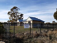
| Rockingham Infant Health Centre |
119 |
|
Corner Wanliss and Smythe Streets |
Rockingham |
|
|
|
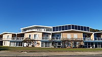
| Rockingham Hotel |
2321 |
26 |
Kent Street |
Rockingham |
32°16′32″S 115°43′53″E / 32.275674°S 115.731428°E / -32.275674; 115.731428 (Rockingham Hotel) |
Port Hotel (former) |

|
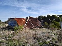
| Site of Old Chalwell House |
2322 |
|
Mandurah Road |
Rockingham |
32°16′08″S 115°46′42″E / 32.268930°S 115.778212°E / -32.268930; 115.778212 (Site of Old Chalwell House) |
Demolished |
|
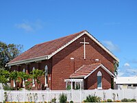
| Anglican Church (former) |
2323 |
63-65 |
Kent Street |
Rockingham |
32°16′25″S 115°44′09″E / 32.273631°S 115.735876°E / -32.273631; 115.735876 (Anglican Church (former)) |
St Nicholas Church |

|
| Second Roads Board Office (former) |
2324 |
41 |
Kent Street |
Rockingham |
32°16′31″S 115°43′58″E / 32.275298°S 115.732773°E / -32.275298; 115.732773 (Second Roads Board Office (Rockingham Museum)) |
Rockingham Museum, Rockingham Districts Historical Society |

|
| Uniting Church |
2328 |
11 |
Florence Street |
Rockingham |
32°16′45″S 115°43′33″E / 32.279246°S 115.725963°E / -32.279246; 115.725963 (Uniting Church) |
Methodist Church, Lutheran Church |
|
| Abattoir (former), East Rockingham |
3126 |
Corner |
Dixon Road & Darile Street |
Hillman |
32°16′41″S 115°46′20″E / 32.277931°S 115.772357°E / -32.277931; 115.772357 (Abattoir (former), East Rockingham) |
|

|
| Baldivis Primary School |
3127 |
342 |
Baldivis Road |
Baldivis |
32°18′27″S 115°49′01″E / 32.307365°S 115.817079°E / -32.307365; 115.817079 (Baldivis Primary School) |
Baldivis Play Group, Day Centre & Art CentreConstructed as part of the Peel Estate scheme |

|
| Bell and Churchill Parks |
3141 |
Lot 148-149 |
Rockingham Beach Road |
Rockingham |
32°16′30″S 115°43′47″E / 32.275059°S 115.729782°E / -32.275059; 115.729782 (Churchill Park) |
|

|
| Bush Reserve |
3144 |
|
Baldivis & Karnup Roads surrounds |
Baldivis |
|
|
|
| East Rockingham Cemetery |
3145 |
231 |
Mandurah Road |
East Rockingham |
32°15′11″S 115°46′57″E / 32.253069°S 115.782583°E / -32.253069; 115.782583 (East Rockingham Cemetery) |
|

|
| Cruising Yacht Club |
3146 |
2 |
Val Street |
Rockingham |
32°16′34″S 115°43′39″E / 32.276064°S 115.727516°E / -32.276064; 115.727516 (Cruising Yacht Club) |
Friday Club |

|
| Frank Churcher's Residence - site |
3147 |
163 |
Rockingham Beach Road |
Rockingham |
32°15′54″S 115°44′40″E / 32.264967°S 115.744422°E / -32.264967; 115.744422 (Frank Churcher's Residence - site) |
Demolished in 2005 |
|
| Freshwater Coral Site |
3148 |
2 |
Lodge Drive |
East Rockingham |
32°16′07″S 115°46′40″E / 32.268722°S 115.777875°E / -32.268722; 115.777875 (Freshwater Coral Site) |
|
|
| Group Settler's Home |
3149 |
118 |
Fifty Road |
Baldivis |
32°18′33″S 115°48′26″E / 32.309281°S 115.807116°E / -32.309281; 115.807116 (Group Settler's Home) |
Constructed as part of the Peel Estate scheme |
|
| Millars Cottages (former) - Site |
3150 |
196 |
Parkin Street |
Rockingham |
32°16′41″S 115°43′44″E / 32.277939°S 115.728873°E / -32.277939; 115.728873 (Millars Cottages (former) - Site) |
Demolished in 2002 |
|
| Natural Bush Reserve, Rear of Baldivis School |
3158 |
342 |
Baldivis Road |
Baldivis |
32°18′23″S 115°49′10″E / 32.306368°S 115.819404°E / -32.306368; 115.819404 (Natural Bush Reserve, Rear of Baldivis School) |
|

|
| Penguin Island and Mersey Point |
3164 |
|
Penguin Island |
Shoalwater |
32°18′16″S 115°42′02″E / 32.304310°S 115.700664°E / -32.304310; 115.700664 (Penguin Island and Mersey Point) |
|

|
| Pine Tree (site of) |
3174 |
Corner |
Rockingham Beach Road & Wanliss Street |
Rockingham |
|
Lone Pine |
|
| Monkhouse Residence - Site |
3183 |
54 |
Penguin Road |
Shoalwater |
32°18′12″S 115°42′33″E / 32.303219°S 115.709294°E / -32.303219; 115.709294 (Monkhouse Residence - Site) |
Demolished in 2005 |
|
| Turtle Factory (former) |
3203 |
|
Point Peron Road |
Peron |
32°16′32″S 115°42′14″E / 32.275525°S 115.703997°E / -32.275525; 115.703997 (Turtle Factory (former)) |
Peron House, Cruising Yacht Club, Sacred Heart ConventDemolished around 1978 |

|
| Rockingham Beach Primary School |
3205 |
30 |
Bay View Street |
Rockingham |
32°16′56″S 115°43′20″E / 32.282242°S 115.722357°E / -32.282242; 115.722357 (Rockingham Beach Primary School) |
Heritage Building |

|
| Rockingham Hotel Walls |
3217 |
32°16′32″S 115°43′54″E / 32.275576°S 115.731728°E / -32.275576; 115.731728 (Rockingham Hotel Walls) |
Kent Street |
Rockingham |
|
|

|
| Rockingham Hotel Trees |
3218 |
26-40 |
Kent Street |
Rockingham |
32°16′32″S 115°43′54″E / 32.275443°S 115.731593°E / -32.275443; 115.731593 (Rockingham Hotel Trees) |
Four pine trees |

|
| Rockingham Oval and Memorial |
3225 |
|
Kent Street, Flinders Lane, Patterson Street |
Rockingham |
32°16′34″S 115°43′58″E / 32.276235°S 115.732890°E / -32.276235; 115.732890 (Rockingham Oval and Memorial) |
Showground, Village Green, War Memorial |

|
| Rockingham Park Kindergarten (former) |
3243 |
Lot 716 |
Centaurus Street |
Rockingham |
32°17′24″S 115°44′19″E / 32.290013°S 115.738531°E / -32.290013; 115.738531 (Rockingham Park Kindergarten (former)) |
Bungaree Kindergarten and Pre-primary, designed by architect and planner Paul Ritter |

|
| Rockingham Park Underpasses |
3245 |
1 |
Council Avenue |
Rockingham |
|
designed by architect and planner Paul Ritter |

|
| Safety Bay Butcher's Shop (former) |
3250 |
44 |
Penguin Road |
Shoalwater |
32°18′13″S 115°42′29″E / 32.303637°S 115.708189°E / -32.303637; 115.708189 (Safety Bay Butcher's Shop (former)) |
|
|
| Safety Bay Yacht Club |
3252 |
|
Safety Bay Road |
Safety Bay |
32°18′17″S 115°42′42″E / 32.304636°S 115.711719°E / -32.304636; 115.711719 (Safety Bay Yacht Club) |
|

|
| Peelhurst (ruins), Golden Bay |
3256 |
178 |
Dampier Drive |
Golden Bay |
32°25′34″S 115°46′11″E / 32.426240°S 115.769718°E / -32.426240; 115.769718 (Peelhurst (ruins), Golden Bay) |
Thomas Peel Reserve, Thomas Peel Juniors Homestead |

|
| Trocadero Dance Hall - Site |
3258 |
25 |
Rockingham Beach Road |
Rockingham |
32°16′29″S 115°43′54″E / 32.274670°S 115.731578°E / -32.274670; 115.731578 (Trocadero Dance Hall - Site) |
Palais de Dance, The Hostel, Trocadero Dance HallDemolished in 2009 |
|
| Challenger Battery |
3301 |
|
Entrance Point |
Garden Island |
32°09′31″S 115°39′53″E / 32.1587°S 115.6647°E / -32.1587; 115.6647 (Challenger Battery) |
"J" Heavy Battery |

|
| Port Kennedy Scientific Park |
3361 |
|
Port Kennedy Dve |
Port Kennedy |
32°22′26″S 115°43′43″E / 32.374019°S 115.728619°E / -32.374019; 115.728619 (Port Kennedy Scientific Park) |
|

|
| Lucy Saw Home |
3370 |
65 |
Parkin Street |
Rockingham |
32°16′48″S 115°43′07″E / 32.280042°S 115.718501°E / -32.280042; 115.718501 (Lucy Saw Home) |
Saw Family Home, Lakeside, Serenity Lodge |

|
| Site of Bell Homestead and Pine Tree |
3637 |
43 |
Rockingham Beach Road |
Rockingham |
32°16′27″S 115°43′56″E / 32.274295°S 115.732184°E / -32.274295; 115.732184 (Site of Bell Homestead and Pine Tree) |
Bell House, Malibu Diving, Lone PineBuilding demolished in the 1960s, tree removed in 1997 |
|
| East Rockingham Heritage Precinct |
3841 |
|
|
Rockingham |
|
|

|
| Penguin Island Kitchen & Store Cave |
4287 |
East Side of |
Penguin Island |
Shoalwater Bay |
32°18′11″S 115°41′26″E / 32.303126°S 115.690693°E / -32.303126; 115.690693 (Penguin Island Kitchen & Store Cave) |
|

|
| Penguin Island Well |
4303 |
East Side of |
Penguin Island |
Shoalwater Bay |
32°18′15″S 115°41′26″E / 32.304182°S 115.690580°E / -32.304182; 115.690580 (Penguin Island Well) |
|

|
| Tuart Tree |
4375 |
|
Anstey Swamp |
Rockingham |
|
|
|
| Garden Island |
4501 |
|
North of |
Rockingham |
32°11′36″S 115°40′16″E / 32.193333°S 115.671111°E / -32.193333; 115.671111 (Garden Island) |
Bauche Island |

|
| Paganoni Swamp & Adjacent Areas |
4502 |
|
Mandurah Road |
Rockingham |
32°26′25″S 115°46′58″E / 32.440163°S 115.782724°E / -32.440163; 115.782724 (Paganoni Swamp & Adjacent Areas) |
|

|
| Point Peron Recreational Camp |
4646 |
|
Point Peron Road |
Rockingham |
32°16′12″S 115°41′28″E / 32.269945°S 115.691116°E / -32.269945; 115.691116 (Point Peron Recreational Camp) |
|
|
| Date Palm Tree |
4863 |
|
Civic Boulevard |
Rockingham |
|
|
|
| Linear Wetlands |
10310 |
|
Quindalup Dunes |
Port Kennedy |
|
|
|
| St Nicholas Church & Z-Force Memorial |
11613 |
Corner |
Baralda Court & Council Avenue |
Rockingham |
32°17′29″S 115°44′41″E / 32.291433°S 115.744699°E / -32.291433; 115.744699 (St Nicholas Church & Z-Force Memorial) |
|

|
| St George's Church |
11615 |
14 |
Scott Road |
Safety Bay |
32°17′55″S 115°42′43″E / 32.298530°S 115.711898°E / -32.298530; 115.711898 (St George's Church) |
|

|
| Rectory |
11636 |
28 |
Brixham Way |
Warnbro |
32°19′59″S 115°45′15″E / 32.333140°S 115.754169°E / -32.333140; 115.754169 (Rectory) |
|
|
| Rockingham Sunday Markets |
12990 |
|
Flinders Lane |
Rockingham |
|
|
|
| Flinder's Hall and Rose Garden (former) |
13053 |
1 |
Empress Corner |
Rockingham |
32°16′34″S 115°44′01″E / 32.276035°S 115.733650°E / -32.276035; 115.733650 (Flinder's Hall and Rose Garden (former)) |
Demolished in 2007 |
|
| Z-Force Memorial, Rockingham |
13166 |
|
The Esplanade |
Rockingham |
32°16′37″S 115°43′14″E / 32.276900°S 115.720445°E / -32.276900; 115.720445 (Z-Force Memorial, Rockingham) |
Catalpa Park |

|
| Iluka |
13651 |
13 |
The Esplanade |
Rockingham |
32°16′33″S 115°42′45″E / 32.275708°S 115.712372°E / -32.275708; 115.712372 (Iluka) |
|

|
| Z-Force Memorial |
13778 |
|
Garden Island North of |
Rockingham |
32°13′23″S 115°41′11″E / 32.222947°S 115.686316°E / -32.222947; 115.686316 (Z-Force Memorial) |
|
|
| Rockingham Fire Station |
14638 |
|
Dixon Road |
Rockingham |
32°16′36″S 115°46′06″E / 32.276654°S 115.768225°E / -32.276654; 115.768225 (Rockingham Fire Station, Dixon Road) |
|
|
| Rockingham Fire Station |
14639 |
|
Hefron Street |
Rockingham |
32°17′30″S 115°44′45″E / 32.291624°S 115.745955°E / -32.291624; 115.745955 (Rockingham Fire Station, Hefron Street) |
|

|
| Rockingham Police Station & Courthouse (former) |
16784 |
|
Corner of Smythe Street & Flinders Lane |
Rockingham |
32°16′37″S 115°44′04″E / 32.276878°S 115.734379°E / -32.276878; 115.734379 (Rockingham Police Station & Courthouse (former)) |
Demolished in 2003 |
|
| Palm Beach Precinct |
16809 |
|
Bounded by Hymus, Lake & Fisher Streets, & beach parallel to The Esplanade |
Rockingham |
32°16′36″S 115°43′14″E / 32.276671°S 115.720509°E / -32.276671; 115.720509 (Palm Beach Precinct) |
|
|
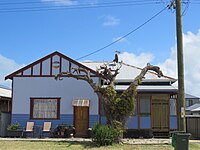
| House |
16810 |
211 |
Safety Bay Road |
Safety Bay |
32°18′08″S 115°42′38″E / 32.302239°S 115.710680°E / -32.302239; 115.710680 (House 211 Safety Bay Road) |
|

|
| Rockingham Police Station & CIB |
17316 |
|
Smyth Street |
Rockingham |
32°16′37″S 115°44′04″E / 32.276878°S 115.734379°E / -32.276878; 115.734379 (Rockingham Police Station & Courthouse (former)) |
Demolished in 2003 |
|
| Elanora - site |
17814 |
49 |
Rockingham Beach Road |
Rockingham |
32°16′26″S 115°43′59″E / 32.273981°S 115.733127°E / -32.273981; 115.733127 (Elanora - site) |
Music House, Bell HouseDemolished around 2007 |
|
| Rockingham Hotel Site |
17865 |
25 |
Rockingham Beach Road |
Rockingham |
|
|
|
| Cliff Point Historic Site |
18184 |
|
Sulphur Bay |
Garden Island |
32°11′15″S 115°40′35″E / 32.187559°S 115.676519°E / -32.187559; 115.676519 (Cliff Point Historic Site) |
Well at Sulphur Bay and Sulphur Town, Foundations of Stirling's Hut |
|
| J.F. Mills' Residence – Site and Tree |
18481 |
|
|
Garden Island |
32°13′47″S 115°41′11″E / 32.229815°S 115.686384°E / -32.229815; 115.686384 (J.F. Mills' Residence – Site and Tree) |
|
|
| Kwinana Grain Terminal, Granary Museum & Jetty |
18482 |
|
Lot 1304 & 1585 Rockingham Beach Road |
East Rockingham |
32°15′31″S 115°45′05″E / 32.258705°S 115.751428°E / -32.258705; 115.751428 (Kwinana Grain Terminal, Granary Museum & Jetty) |
|

|
| Timber Railway - site |
18484 |
|
Railway Terrace |
Rockingham |
32°16′35″S 115°43′45″E / 32.276395°S 115.729281°E / -32.276395; 115.729281 (Timber Railway - site) |
Part of the Jarrahdale to Rockingham railway line, Railway tracks removed in 1949 |
|
| Police Station - site |
18485 |
Lot 8002 |
Kent Street |
Rockingham |
32°16′35″S 115°43′52″E / 32.276306°S 115.731057°E / -32.276306; 115.731057 (Police Station - site) |
Demolished in 1976 |
|
| Rockingham Beach School - site |
18486 |
9 |
Kent Street |
Rockingham |
32°16′36″S 115°43′51″E / 32.276760°S 115.730738°E / -32.276760; 115.730738 (Rockingham Beach School - site) |
Demolished in the 1960s |
|
| Fisher's Bakery - site |
18487 |
175 |
Parkin Street |
Rockingham |
32°16′38″S 115°43′46″E / 32.277320°S 115.729569°E / -32.277320; 115.729569 (Fisher's Bakery - site) |
Demolished, date unknown |
|
| Rockingham Cairn |
18488 |
Lot 439 |
Rockingham Beach Road |
East Rockingham |
32°15′41″S 115°44′50″E / 32.261435°S 115.747139°E / -32.261435; 115.747139 (Rockingham Cairn) |
|

|
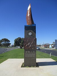
| Founders' Memorial |
18489 |
|
Railway Terrace |
Rockingham |
32°16′37″S 115°43′48″E / 32.277056°S 115.730000°E / -32.277056; 115.730000 (Founders' Memorial) |
|
|
| Rockingham Beach Post Office - site |
18490 |
|
Corner Kent Street & Railway Terrace |
Rockingham |
32°16′35″S 115°43′47″E / 32.276478°S 115.729797°E / -32.276478; 115.729797 (Rockingham Beach Post Office - site) |
Demolished around 1984 |
|
| Masonic Hall |
18491 |
13 |
Wanliss Street |
Rockingham |
32°16′33″S 115°44′12″E / 32.275838°S 115.736763°E / -32.275838; 115.736763 (Masonic Hall) |
|
|
| Alfred Hines Seaside Home |
18492 |
1 |
Hymus Street |
Peron |
32°16′34″S 115°42′38″E / 32.276047°S 115.710628°E / -32.276047; 115.710628 (Alfred Hines Seaside Home) |
Seaside Camp for Children, Crippled Children's Seaside Home |

|
| A.J.H. Watts Land Sales Office (former) |
18493 |
229 |
Safety Bay Road |
Safety Bay |
32°18′13″S 115°42′40″E / 32.303676°S 115.711197°E / -32.303676; 115.711197 (A.J.H. Watts Land Sales Office (former)) |
Glenway Realty |

|
| Palm Beach Jetty - site |
18494 |
|
End of Fisher Street, Palm Beach, Mangles Bay |
Rockingham |
32°16′34″S 115°43′14″E / 32.275988°S 115.720586°E / -32.275988; 115.720586 (Palm Beach Jetty - site) |
Naval Jetty (Site of), Fisher Street Jetty, Pine Beach JettyDemolished in 2008 and replaced with a new jetty in 2010 |

|
| Garden Island Batteries |
18495 |
|
Cockburn Sound Locations 9 & 696 |
Garden Island |
|
Beacon Battery, Scriven Hill Battery and Collie Section Battery, Challenger Battery |
|
| Sites of Three Timber Jetties |
18496 |
|
Palm Beach, west of Railway Terrace |
Rockingham |
32°16′29″S 115°43′41″E / 32.274732°S 115.728158°E / -32.274732; 115.728158 (Sites of Three Timber Jetties) |
Part of the Jarrahdale to Rockingham railway line, final structures removed in 2009 |
|
| Dato Shipwreck |
18622 |
|
Careening Bay |
Garden Island |
32°14′15″S 115°41′29″E / 32.237500°S 115.691389°E / -32.237500; 115.691389 (Dato Shipwreck) |
|
|
| Chalmers Shipwreck |
18632 |
|
|
Port Kennedy |
32°22′02″S 115°41′26″E / 32.367167°S 115.690617°E / -32.367167; 115.690617 (Chalmers Shipwreck) |
|
|
| Hero of the Nile Shipwreck |
18654 |
|
|
Port Kennedy |
32°21′52″S 115°42′21″E / 32.364450°S 115.705950°E / -32.364450; 115.705950 (Hero of the Nile Shipwreck) |
|
|
| Star Shipwreck |
18732 |
|
Murray Reefs |
3km West of Port Kennedy/Warnbro Sound |
32°22′35″S 115°41′02″E / 32.376500°S 115.683833°E / -32.376500; 115.683833 (Star Shipwreck) |
|
|
| Rockingham Jetty |
18779 |
|
Opposite Railway Road |
Rockingham |
32°16′31″S 115°43′35″E / 32.275316°S 115.726483°E / -32.275316; 115.726483 (Rockingham Jetty) |
Final structures of original jetty removed in 2009, replaced by new jetty |

|
| Secret Harbour Police Station |
19000 |
|
Oneida Road |
Secret Harbour |
|
|
|
| Carinya Court |
19932 |
153 |
Esplanade |
Rockingham |
32°16′35″S 115°43′38″E / 32.276369°S 115.727157°E / -32.276369; 115.727157 (Carinya Court) |
Esplanade Flats, designed by architect Julius Elischer |
|
| CWA Centre |
19933 |
12 |
Watts Road |
Shoalwater |
32°18′03″S 115°42′34″E / 32.300885°S 115.709554°E / -32.300885; 115.709554 (CWA Centre) |
|

|
| Arcadia House - Site |
19934 |
216 |
Arcadia Drive |
Safety Bay |
32°18′15″S 115°42′38″E / 32.304189°S 115.710479°E / -32.304189; 115.710479 (Arcadia House - Site) |
Ye Olde Safety Bay Inn, Safety Bay Guest House, Arcadia Lodge, C Side Lodge, Gregmar Lodge, Kingsview LodgeDemolished in 2007 |
|
| Golf Course - Site |
19935 |
Corner |
Patterson Road and Read Street |
Rockingham |
32°16′56″S 115°44′24″E / 32.282218°S 115.739879°E / -32.282218; 115.739879 (Golf Course - Site) |
Relocated in 1985 |
|
| Racecourse - Site |
19936 |
|
Flinders Lane |
Rockingham |
32°16′30″S 115°44′02″E / 32.274977°S 115.733841°E / -32.274977; 115.733841 (Racecourse - Site) |
|
|
| Rockingham Roads Board Site |
19937 |
90 |
Office Road |
East Rockingham |
32°15′01″S 115°46′55″E / 32.250213°S 115.781995°E / -32.250213; 115.781995 (Rockingham Roads Board Site) |
Roads Boards Office and East Rockingham School - Site |

|
| Rockingham Theatres - site |
19938 |
|
Kent Street |
Rockingham |
32°16′31″S 115°43′56″E / 32.275219°S 115.732202°E / -32.275219; 115.732202 (Rockingham Theatres - site) & 32°16′35″S 115°43′49″E / 32.276401°S 115.730193°E / -32.276401; 115.730193 (Century Gardens - Rockingham Theatres - site) |
Demolished |
|
| Aloha & Oahu |
19939 |
166 - 168 |
Arcadia Drive |
Shoalwater |
32°18′18″S 115°42′13″E / 32.305055°S 115.703652°E / -32.305055; 115.703652 (Aloha & Oahu) |
|

|
| Residence, 118 Arcadia Drive |
19940 |
118 |
Arcadia Drive |
Shoalwater |
32°18′04″S 115°42′15″E / 32.301001°S 115.704270°E / -32.301001; 115.704270 (Residence, 118 Arcadia Drive) |
Demolished in December 2023 |

|
| Residence, 250 Safety Bay Road |
19941 |
250 |
Safety Bay Road |
Safety Bay |
32°18′15″S 115°42′50″E / 32.304039°S 115.713762°E / -32.304039; 115.713762 (Residence, 250 Safety Bay Road) |
|

|
| Residence, 505 Safety Bay Road |
19942 |
505 |
Safety Bay Road |
Safety Bay |
32°18′54″S 115°44′20″E / 32.315080°S 115.738895°E / -32.315080; 115.738895 (Residence, 505 Safety Bay Road) |
|
|
| Residence, 623 Safety Bay Road |
19943 |
623 |
Safety Bay Road |
Waikiki |
32°19′28″S 115°44′49″E / 32.324381°S 115.746966°E / -32.324381; 115.746966 (Residence, 623 Safety Bay Road) |
|
|
| Residence, 72a Penguin Road |
19944 |
72a |
Penguin Road |
Safety Bay |
32°18′11″S 115°42′43″E / 32.303108°S 115.711969°E / -32.303108; 115.711969 (Residence, 72a Penguin Road) |
|
|
| Residence, 188 Safety Bay Road |
19945 |
188 |
Safety Bay Road |
Safety Bay |
32°18′00″S 115°42′38″E / 32.299873°S 115.710585°E / -32.299873; 115.710585 (Residence, 188 Safety Bay Road) |
|

|
| Residence, 218 Safety Bay Road |
19946 |
218 |
Safety Bay Road |
Safety Bay |
32°18′09″S 115°42′41″E / 32.302621°S 115.711384°E / -32.302621; 115.711384 (Residence, 218 Safety Bay Road) |
|
|
| Residence, 3 Chalwell Street |
19947 |
3 |
Chalwell Street |
Rockingham |
32°16′39″S 115°43′02″E / 32.277491°S 115.717211°E / -32.277491; 115.717211 (Residence, 3 Chalwell Street) |
|
|
| Residence, 21 Waimea Road |
19948 |
21 |
Waimea Road |
Safety Bay |
32°18′00″S 115°42′50″E / 32.299915°S 115.713818°E / -32.299915; 115.713818 (Residence, 21 Waimea Road) |
|

|
| Residence, 5 Martell Street |
19949 |
5 |
Martell Street |
Warnbro |
32°19′56″S 115°44′59″E / 32.332351°S 115.749614°E / -32.332351; 115.749614 (Residence, 5 Martell Street) |
|
|
| Residence, 274 Safety Bay Road |
19950 |
274 |
Safety Bay Road |
Safety Bay |
32°18′17″S 115°42′59″E / 32.304743°S 115.716412°E / -32.304743; 115.716412 (Residence, 274 Safety Bay Road) |
|

|
| Residence, 124 Arcadia Drive |
20047 |
124 |
Arcadia Drive |
Shoalwater |
32°18′06″S 115°42′15″E / 32.301551°S 115.704087°E / -32.301551; 115.704087 (Residence, 124 Arcadia Drive) |
|

|
| Limestone Quarry |
24537 |
|
Chesterfield Road |
East Rockingham |
32°15′52″S 115°46′27″E / 32.264363°S 115.774087°E / -32.264363; 115.774087 (Limestone Quarry) |
|
|
| AIW Centre, Peron |
25661 |
2058 |
Point Peron Road |
Peron |
32°16′35″S 115°42′32″E / 32.276512°S 115.709025°E / -32.276512; 115.709025 (AIW Centre, Peron) |
Demolished in 2017 |
|
| RSL Caravan Park, Peron |
25662 |
Lot 501 |
Point Peron Road |
Peron |
32°16′35″S 115°42′27″E / 32.276446°S 115.707536°E / -32.276446; 115.707536 (RSL Caravan Park, Peron) |
|

|
| Keralup Bridge, Keralup |
26204 |
|
Young Road |
Baldivis |
32°21′19″S 115°50′22″E / 32.355384°S 115.839509°E / -32.355384; 115.839509 (Keralup Bridge) |
|
|
| Reverend Purdy's House (former) |
26778 |
67 |
Rockingham Beach Road |
Rockingham |
32°16′22″S 115°44′08″E / 32.272785°S 115.735645°E / -32.272785; 115.735645 (Reverend Purdy's House (former)) |
|

|
| Sutton Residence (former) |
26779 |
30 |
Rae Road |
Safety Bay |
32°17′51″S 115°42′54″E / 32.297585°S 115.714961°E / -32.297585; 115.714961 (Sutton Residence (former)) |
|
|