55:
267:
339:
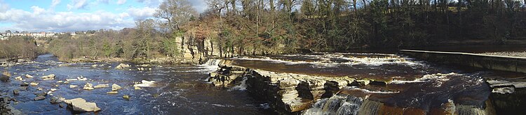
48:, their normally medial size can be affected easily, much like the rest of the Swale, by heavy rain and flooding, making for dramatic viewing. Because of the steep nature of the rocks, the falls are a barrier to fish passage upstream.
155:
380:
108:
409:
399:
300:
148:
28:
373:
404:
92:
191:
141:
61:
366:
54:
251:
181:
33:
266:
281:
88:
246:
256:
201:
45:
37:
221:
350:
241:
176:
44:
last waterfalls on the Swale before the river reaches the lower country grounds of the
393:
346:
231:
216:
186:
226:
211:
206:
196:
286:
23:
315:
302:
338:
109:"Upper Swale Sub-Catchment Evidence Pack for the Water Framework Directive"
85:
The waterfalls of
England : a practical guide for visitors and walkers
133:
137:
354:
274:
169:
374:
149:
8:
381:
367:
156:
142:
134:
87:. Wilmslow: Sigma Leisure. p. 133.
75:
26:, they are situated at grid reference
16:Waterfalls in North Yorkshire, England
22:are a series of waterfalls along the
7:
335:
333:
14:
337:
265:
53:
1:
410:Richmondshire geography stubs
400:Waterfalls of North Yorkshire
116:yorkshiredalesriverstrust.com
353:. You can help Knowledge by
32:near to the town centre of
426:
332:
64:Panorama of Richmond Falls
40:. They are one of, if not
405:Richmond, North Yorkshire
263:
83:Fellows, Griff J (2003).
164:Waterfalls of Yorkshire
349:location article is a
316:54.401025°N 1.734254°W
321:54.401025; -1.734254
312: /
362:
361:
295:
294:
417:
383:
376:
369:
341:
334:
327:
326:
324:
323:
322:
317:
313:
310:
309:
308:
305:
269:
158:
151:
144:
135:
128:
127:
125:
123:
113:
105:
99:
98:
80:
57:
31:
425:
424:
420:
419:
418:
416:
415:
414:
390:
389:
388:
387:
330:
320:
318:
314:
311:
306:
303:
301:
299:
298:
296:
291:
270:
261:
170:North Yorkshire
165:
162:
132:
131:
121:
119:
111:
107:
106:
102:
95:
82:
81:
77:
72:
67:
66:
65:
63:
58:
46:Vale of Mowbray
38:North Yorkshire
27:
17:
12:
11:
5:
423:
421:
413:
412:
407:
402:
392:
391:
386:
385:
378:
371:
363:
360:
359:
342:
293:
292:
290:
289:
284:
278:
276:
275:West Yorkshire
272:
271:
264:
262:
260:
259:
254:
249:
244:
242:Scaleber Force
239:
234:
229:
224:
219:
214:
209:
204:
199:
194:
192:Cauldron Falls
189:
184:
182:Beezeley Falls
179:
173:
171:
167:
166:
163:
161:
160:
153:
146:
138:
130:
129:
100:
93:
74:
73:
71:
68:
60:
59:
52:
51:
50:
20:Richmond Falls
15:
13:
10:
9:
6:
4:
3:
2:
422:
411:
408:
406:
403:
401:
398:
397:
395:
384:
379:
377:
372:
370:
365:
364:
358:
356:
352:
348:
347:Richmondshire
343:
340:
336:
331:
328:
325:
288:
285:
283:
280:
279:
277:
273:
268:
258:
255:
253:
250:
248:
245:
243:
240:
238:
235:
233:
232:Mallyan Spout
230:
228:
225:
223:
220:
218:
215:
213:
210:
208:
205:
203:
200:
198:
195:
193:
190:
188:
185:
183:
180:
178:
175:
174:
172:
168:
159:
154:
152:
147:
145:
140:
139:
136:
117:
110:
104:
101:
96:
94:1-85058-767-1
90:
86:
79:
76:
69:
62:
56:
49:
47:
43:
39:
35:
30:
25:
21:
355:expanding it
344:
329:
297:
236:
222:Janet's Foss
212:Gordale Scar
207:Falling Foss
120:. Retrieved
115:
103:
84:
78:
41:
19:
18:
319: /
118:. p. 1
24:River Swale
394:Categories
304:54°24′04″N
287:Goit Stock
247:Stainforth
70:References
307:1°44′03″W
257:Wain Wath
202:East Gill
252:Thornton
237:Richmond
177:Aysgarth
34:Richmond
29:NZ173006
217:Hardraw
187:Catrake
122:21 June
282:Brontë
227:Kisdon
197:Cotter
91:
345:This
112:(PDF)
351:stub
124:2019
89:ISBN
42:the
396::
114:.
36:,
382:e
375:t
368:v
357:.
157:e
150:t
143:v
126:.
97:.
Text is available under the Creative Commons Attribution-ShareAlike License. Additional terms may apply.