161:
17:
236:
202:
47:
and are located on the western half of the island. Islander Camp is located on the east side of the island, and is used primarily by the
Islander Teen Expedition, a
231:
241:
43:, which has five camping areas set up for its use. Two of the camps, Sunset Camp and Fellowship Camp, are used for overnight island trips by campers from
195:
102:
39:, United States. It has a land area of 116.42 acres (47.11 ha) and no resident population as it is a private island owned by the
125:
188:
55:. Mariner Camp is located on the east side of the island, near Islander Camp, and is used by the Mariner Teen Expedition, a
168:
36:
28:
221:
20:
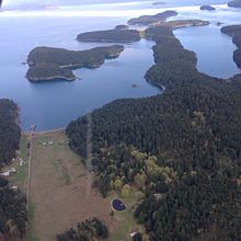
Stuart Island
Airpark (foreground) lies on the western shore of Prevost Harbour across from Satellite Island
67:
98:
172:
71:
44:
32:
226:
215:
52:
160:
92:
16:
140:
127:
117:
Satellite Island: Block 4010, Census Tract 9603, San Juan County, Washington
48:
56:
15:
40:
116:
176:
196:
8:
62:Satellite Island commemorates the ship (HMS
27:lies in Prevost Harbor on the north side of
203:
189:
237:Uninhabited islands of Washington (state)
66:) captained by the British naval officer
97:. Van Winkle Publishing Co. p. 14.
83:
232:Private islands of Washington (state)
7:
157:
155:
242:Washington (state) geography stubs
175:. You can help Knowledge (XXG) by
14:
51:trip which crosses into Canada's
159:
1:
171:state location article is a
169:San Juan County, Washington
119:United States Census Bureau
37:San Juan County, Washington
258:
154:
91:Majors, Harry M. (1975).
70:, who was stationed at
21:
68:James Charles Prevost
19:
141:48.6814°N 123.1909°W
94:Exploring Washington
59:trip for teenagers.
137: /
74:from 1857 to 1860.
146:48.6814; -123.1909
22:
184:
183:
104:978-0-918664-00-6
249:
222:San Juan Islands
205:
198:
191:
163:
156:
152:
151:
149:
148:
147:
142:
138:
135:
134:
133:
130:
109:
108:
88:
72:Vancouver Island
45:YMCA Camp Orkila
33:San Juan Islands
25:Satellite Island
257:
256:
252:
251:
250:
248:
247:
246:
212:
211:
210:
209:
145:
143:
139:
136:
131:
128:
126:
124:
123:
113:
112:
105:
90:
89:
85:
80:
12:
11:
5:
255:
253:
245:
244:
239:
234:
229:
224:
214:
213:
208:
207:
200:
193:
185:
182:
181:
164:
121:
120:
111:
110:
103:
82:
81:
79:
76:
13:
10:
9:
6:
4:
3:
2:
254:
243:
240:
238:
235:
233:
230:
228:
225:
223:
220:
219:
217:
206:
201:
199:
194:
192:
187:
186:
180:
178:
174:
170:
165:
162:
158:
153:
150:
118:
115:
114:
106:
100:
96:
95:
87:
84:
77:
75:
73:
69:
65:
60:
58:
54:
50:
46:
42:
38:
34:
30:
29:Stuart Island
26:
18:
177:expanding it
166:
122:
93:
86:
63:
61:
53:Gulf Islands
24:
23:
144: /
132:123°11′27″W
216:Categories
129:48°40′53″N
78:References
64:Satellite
49:kayaking
57:sailing
31:in the
101:
167:This
227:YMCA
173:stub
99:ISBN
41:YMCA
35:of
218::
204:e
197:t
190:v
179:.
107:.
Text is available under the Creative Commons Attribution-ShareAlike License. Additional terms may apply.