36:
43:
199:
the deposits, providing roof support and preventing spontaneous combustion would be insurmountable problems. A large part of the resource is low grade bituminous, suitable for local power generation but not for export. Other drawbacks to the
Waterberg Coalfield include its distance from industrial centers in South Africa, lack of infrastructure in the area and lack of water supplies. Large amounts of water are needed for both the mines and the power stations.
198:
in the
Grootegeluk Formation, which is around 70 metres (230 ft) thick. Although some of the resources are near the surface and readily accessible, it may not be economically viable to extract coals from the seams that lie at depths of up to 400 metres (1,300 ft). Due to the thickness of
187:. They were deposited from 260 to 190 million years ago, and are bounded by the Limpopo Mobile Belt to the north and the Eenzaamheid and Ellisras Faults to the south. The more recent Daarby Fault cuts across the coalfield. The recent covering comes from weathering of Limpopo Mobile Belt
202:
However, the reserve is very large and could potentially be mined for the next 200 years. It seems plausible that industry will move to the region, infrastructure will be developed and ways will be found to bring water from other regions. The
Waterberg Coalfield may well replace the
279:
railway would reduce load on the coal-carrying lines. Transnet was working with the mining companies to ensure that available capacity was being used, and that there was sufficient capacity. This could include long-term contracts to reduce risk on either side.
324:
which existence is already endangered. Growth of the human population, with new housing and new agricultural operations may add more stress. Mine and power station design and operation must understand these impacts and include measures to minimize the impact.
328:
On the other hand, many of the local people are unskilled and unemployed. Development of the coalfields and related chemical industries, with improvements to infrastructure, education and health services could provide large benefits if managed correctly.
259:
is also interested in exploiting the field with a planned new power station called
Project Mafutha, which may be located in the Waterberg. A joint venture between the Australian Firestone Energy and the local Sekoko coal is also active in the region.
577:
Faure, Kevin; Willis, James P.; Dreyer, J. Claris (January 1996). "The
Grootegeluk Formation in the Waterberg Coalfield, South Africa: facies, palaeoenvironment and thermal history — evidence from organic and clastic matter".
227:
bought the surface rights on six farms in 1957, and in 1973 began intensive exploration to assess the quantity and quality of coal on this property. Iscor bought the mining lease on the farms in 1979 and established the
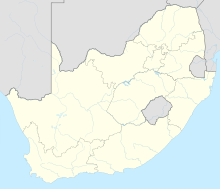
176:, to the west. It contains about 40% of South Africa's coal resources. The Waterberg Coalfield has been estimated to hold about 50 billion tons, of which about a quarter could be extracted using
152:
province. Mining is increasing, both for export and for local power production, and industry in the region is expected to expand. This may have significant impact on the dry and fragile
168:. Its dimensions are about 85 kilometres (53 mi) from east to west and about 40 kilometres (25 mi) from north to south. It is part of the same formation as the
275:
stated that they were adding enough capacity to be able to ship an additional 23 million tons of coal a year from the
Waterberg Coalfield to Richards Bay. The new
655:
New Trends in Coal
Preparation Technologies and Equipment: Proceedings of the 12th International Coal Preparation Congress, Cracow, Poland, May 23-27, 1994
727:
35:
82:
255:, which is also in the Waterberg and was due to open in 2012. Because of the shortage of water, the Medupi station will use air-cooled condensers.
710:
223:, 143 diamond-drill holes and two prospecting shafts were sunk between 1941 and 1952 to obtain a geological map of the Waterberg coalfield.
539:
746:
663:
652:
Horsfall, David W.; Eroglu, Berrin (September 1995). "Optimum
Beneficiation Routes for Waterberg Coal". In Blaschke, Wieslaw (ed.).
145:
793:
798:
224:
633:
765:
309:
616:"New airborne geophysical data from the Waterberg Coalfield – South Africa's major future energy source"
248:
229:
264:
252:
320:
released into the atmosphere will affect the
Limpopo basin ecosystem, which contains some unique
706:
700:
659:
653:
615:
587:
240:
184:
191:
and Karoo rock in the north, and from weathering of the
Waterberg sandstones in the south.
559:
233:
177:
543:
219:
in 1920, but for many years little was done to explore the resource. During and after
216:
137:
787:
591:
317:
153:
600:
164:
The Waterberg Coalfield is located in the Limpopo province of South Africa, west of
268:
220:
141:
348:
346:
674:
313:
301:
297:
293:
204:
97:
84:
289:
276:
169:
165:
675:"Challenges associated with further development of the Waterberg Coalfield"
728:"Abundant Waterberg coalfield capable of hosting many more power stations"
272:
195:
173:
766:"Technical Resource Statement, Waterberg Project as at 1 November 2009"
321:
305:
300:
are important economic activities. There are very limited resources of
149:
188:
352:
682:
The Journal of the South African Institute of Mining and Metallurgy
412:
410:
183:
The coal-bearing rocks are in the Grootegeluk Formation within the
263:
Exxaro expects to expand exports of high-quality coal through the
256:
244:
133:
308:, and this must be avoided. There is danger of self-heating or
251:. In 2007 Exxaro had obtained a contract to supply Eskom's new
702:
Climate Change and National Security: A Country-Level Analysis
288:
The Waterberg area has huge areas of natural bush, and many
478:
476:
505:
503:
439:
437:
236:
colliery was the only coal operation in the coalfield.
560:"Transnet can unlock 23Mt/y from Waterberg coalfield"
416:
207:
coalfields, which are now reaching peak production.
397:
395:
393:
391:
389:
387:
385:
271:. In February 2012, the state-owned rail company
243:was operating the Grootegeluk coal mine, supplying
118:
113:
76:
68:
60:
24:
428:
614:Fourie, CJS; Du Plessis, SJ; Henry, G (2006).
304:. Other coal mining operations have polluted
194:Thin layers of coal alternate with layers of
8:
621:. CSIR Natural Resources and the Environment
364:
19:
482:
42:
376:
18:
353:Firestone Energy, Waterberg coal project
521:
509:
494:
467:
455:
443:
342:
316:, releasing toxic gases. Deposition of
634:"Grootegeluk Coal Mine, South Africa"
580:International Journal of Coal Geology
401:
7:
558:Creamer, Martin (1 February 2012).
417:Fourie, Du Plessis & Henry 2006
14:
41:
34:
726:Ndaba, Dennis (20 March 2008).
705:. Georgetown University Press.
429:Faure, Willis & Dreyer 1996
146:Waterberg District Municipality
1:
16:Mine in Limpopo, South Africa
699:Moran, Daniel (2011-04-15).
592:10.1016/0166-5162(95)00029-1
538:CIC Energy (February 2012).
751:Limpopo River Awareness Kit
132:is an extensive deposit of
815:
745:Oberholster, Paul (2010).
673:Jeffrey, L. (July 2005).
29:
601:"Waterberg coal project"
310:spontaneous combustion
232:in 1980. In 2005 this
215:Coal was found in the
144:, lying mostly in the
747:"Waterberg Coalfield"
540:"Mmamabula Coalfield"
249:Matimba Power Station
230:Grootegeluk Coal Mine
98:23.66667°S 27.51667°E
794:Coal in South Africa
658:. pp. 527–536.
265:Port of Richards Bay
253:Medupi Power Station
130:Waterberg Coalfield
103:-23.66667; 27.51667
94: /
49:Waterberg Coalfield
21:
20:Waterberg Coalfield
799:Economy of Limpopo
771:. Firestone Energy
764:Sekoko Resources.
599:Firestone Energy.
712:978-1-58901-741-2
126:
125:
806:
779:
777:
776:
770:
760:
758:
757:
741:
739:
738:
722:
720:
719:
695:
693:
692:
679:
669:
648:
646:
645:
629:
627:
626:
620:
610:
608:
607:
595:
586:(1–3): 147–186.
573:
571:
570:
554:
552:
551:
542:. Archived from
525:
519:
513:
507:
498:
492:
486:
483:Oberholster 2010
480:
471:
465:
459:
453:
447:
441:
432:
426:
420:
414:
405:
399:
380:
374:
368:
365:Sekoko Resources
362:
356:
350:
241:Exxaro Resources
185:Karoo Supergroup
109:
108:
106:
105:
104:
99:
95:
92:
91:
90:
87:
45:
44:
38:
22:
814:
813:
809:
808:
807:
805:
804:
803:
784:
783:
782:
774:
772:
768:
763:
755:
753:
744:
736:
734:
725:
717:
715:
713:
698:
690:
688:
677:
672:
666:
651:
643:
641:
632:
624:
622:
618:
613:
605:
603:
598:
576:
568:
566:
557:
549:
547:
537:
533:
528:
520:
516:
508:
501:
493:
489:
481:
474:
466:
462:
454:
450:
442:
435:
427:
423:
415:
408:
400:
383:
377:CIC Energy 2012
375:
371:
363:
359:
351:
344:
340:
335:
286:
213:
178:opencast mining
162:
102:
100:
96:
93:
88:
85:
83:
81:
80:
56:
55:
54:
53:
52:
51:
50:
46:
17:
12:
11:
5:
812:
810:
802:
801:
796:
786:
785:
781:
780:
761:
742:
723:
711:
696:
670:
664:
649:
630:
611:
596:
574:
555:
534:
532:
529:
527:
526:
524:, p. 456.
514:
512:, p. 457.
499:
487:
472:
470:, p. 454.
460:
458:, p. 455.
448:
446:, p. 453.
433:
431:, p. 147.
421:
406:
381:
369:
357:
341:
339:
336:
334:
331:
318:waste products
312:from dumps of
285:
282:
247:'s coal-fired
217:Ellisras Basin
212:
209:
172:coalfields in
161:
158:
138:Ellisras Basin
124:
123:
120:
116:
115:
111:
110:
78:
74:
73:
70:
66:
65:
62:
58:
57:
48:
47:
40:
39:
33:
32:
31:
30:
27:
26:
15:
13:
10:
9:
6:
4:
3:
2:
811:
800:
797:
795:
792:
791:
789:
767:
762:
752:
748:
743:
733:
732:Mining Weekly
729:
724:
714:
708:
704:
703:
697:
687:
683:
676:
671:
667:
665:9782884491396
661:
657:
656:
650:
640:. 9 June 2000
639:
638:Mining Weekly
635:
631:
617:
612:
602:
597:
593:
589:
585:
581:
575:
565:
564:Mining Weekly
561:
556:
546:on 2010-11-06
545:
541:
536:
535:
530:
523:
518:
515:
511:
506:
504:
500:
496:
491:
488:
484:
479:
477:
473:
469:
464:
461:
457:
452:
449:
445:
440:
438:
434:
430:
425:
422:
418:
413:
411:
407:
403:
398:
396:
394:
392:
390:
388:
386:
382:
378:
373:
370:
366:
361:
358:
354:
349:
347:
343:
337:
332:
330:
326:
323:
319:
315:
311:
307:
303:
299:
295:
291:
283:
281:
278:
274:
270:
266:
261:
258:
254:
250:
246:
242:
237:
235:
231:
226:
222:
218:
210:
208:
206:
200:
197:
192:
190:
186:
181:
179:
175:
171:
167:
159:
157:
155:
154:Limpopo basin
151:
147:
143:
139:
135:
131:
121:
117:
112:
107:
79:
75:
71:
67:
63:
59:
37:
28:
23:
773:. Retrieved
754:. Retrieved
750:
735:. Retrieved
731:
716:. Retrieved
701:
689:. Retrieved
685:
681:
654:
642:. Retrieved
637:
623:. Retrieved
604:. Retrieved
583:
579:
567:. Retrieved
563:
548:. Retrieved
544:the original
522:Jeffrey 2005
517:
510:Jeffrey 2005
495:Creamer 2012
490:
468:Jeffrey 2005
463:
456:Jeffrey 2005
451:
444:Jeffrey 2005
424:
372:
367:, p. 3.
360:
327:
287:
269:Indian Ocean
262:
239:As of 2008,
238:
221:World War II
214:
211:Exploitation
201:
193:
182:
163:
156:ecosystems.
142:South Africa
129:
127:
72:South Africa
302:groundwater
298:agriculture
101: /
77:Coordinates
788:Categories
775:2012-12-24
756:2012-09-25
737:2012-09-25
718:2012-09-22
691:2012-09-25
644:2012-09-25
625:2012-09-25
606:2012-09-25
569:2012-09-25
550:2012-09-21
402:Ndaba 2008
333:References
314:waste coal
294:Ecotourism
290:game farms
205:Mpumalanga
114:Production
338:Citations
277:Swazilink
196:mudstones
170:Mmamabula
166:Lephalale
89:27°31′0″E
86:23°40′0″S
306:aquifers
284:Concerns
273:Transnet
234:open-pit
174:Botswana
160:Resource
119:Products
61:Province
25:Location
531:Sources
322:species
267:on the
150:Limpopo
148:of the
136:in the
69:Country
64:Limpopo
709:
662:
189:gneiss
769:(PDF)
678:(PDF)
619:(PDF)
257:Sasol
245:Eskom
225:Iscor
707:ISBN
660:ISBN
296:and
134:coal
128:The
122:Coal
686:105
588:doi
292:.
140:in
790::
749:.
730:.
684:.
680:.
636:.
584:29
582:.
562:.
502:^
475:^
436:^
409:^
384:^
345:^
180:.
778:.
759:.
740:.
721:.
694:.
668:.
647:.
628:.
609:.
594:.
590::
572:.
553:.
497:.
485:.
419:.
404:.
379:.
355:.
Text is available under the Creative Commons Attribution-ShareAlike License. Additional terms may apply.