102:
109:
29:
231:
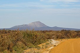
West Mount Barren rises 372 metres above sea level and forms part of the Barren Range within the national park. Mount Bland (320 metres) is the closest mountain feature and is situated approximately 5 km northeast from West Mount Barren. The Barren range is not continuous and although there are
406:
strikes are the most usual cause of fires that often devastate large areas of the park. The last large scale fire was in
December 2006 where four fires, that were started by lightning strikes, joined into one much larger blaze that burned out several thousand
243:
vehicles that runs off
Pabelup Drive. A carpark with a plaque at the base of the mountain marks the beginning of a track that is an easy two hour return walk to the summit. Visitors are encouraged to stay on the footpath so as to minimise the spread of
480:
Johnson, S.L. (1998). Hydrogeology of the
Ravensthorpe 1:250,000 Sheet: Western Australia, Hydrogeological Map Explanatory Notes Series, Report HM 4, Water and Rivers Commission, East Perth, Western Australia.
232:
three distinct Mount
Barrens (West, Mid and East) they are distinct peaks that are connected by coastal plain. Mid Mount Barren is approximately 20 km northeast of West Mount Barren and
101:
134:
558:
236:
is approximately 50 km northeast of West Mount Barren. Other peaks in the area include
Woolbernup Hill, Thumb Peak, Mt Drummond and Mt Maxwell.
521:
553:
58:
458:
162:
184:
431:
166:
51:
348:
Several species are unique to the area and can be found on and around West Mount Barren. Species include royal hakea (
170:
310:. These rock beds were once layers of sand deposited on the sea floor. They were subsequently compressed, heated and
511:
George, A.S. (1974). Five new species of
Adenanthos (Proteaceae) from Western Australia. in Nuytsia 1(4):381-386.
326:
surrounding West Mount Barren is best described as scrub-heath with many types of shrubs that thrive in the
303:
245:
525:
362:
490:
380:
178:
368:
233:
216:
174:
138:
374:
356:
220:
386:
311:
299:
350:
307:
288:
284:
264:
145:
462:. Perth, Western Australia: National Library of Australia. 5 February 1928. p. 18
547:
28:
251:
A commanding view of the national park and the coastline is seen from the summit.
276:
338:
323:
453:
199:
186:
73:
60:
403:
399:
342:
327:
291:
259:
The
Ravensthorpe region is underlain by basement rocks of the Albany-Fraser
408:
331:
295:
280:
268:
272:
260:
41:
306:. The Barrens are composed of rock beds that have been tilted and
239:
West Mount Barren is accessible by an unsealed road suitable for
334:
240:
283:
rocks. The Barren Ranges consist of metasediments, mostly
398:
The area around West Mount Barren is often burnt out by
522:"The West Australian - Massive blaze in national park"
248:
which is a threat to the native plants of the area.
337:, often in rocky situations. The shrubs are mostly
144:
130:
89:
50:
40:
35:
21:
426:
424:
432:"Park Finder - Fitzgerald River National Park"
8:
18:
108:
420:
223:in 1802 after their barren appearance.
219:and Mid-Mount Barren were all named by
7:
384:), and the broad-leaved brown pea (
314:by movements of the Earth's crust.
559:Great Southern (Western Australia)
372:), silver-leafed Barrens regelia (
14:
107:
100:
27:
554:Mountains of Western Australia
215:West Mount Barren, along with
163:Fitzgerald River National Park
1:
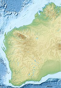
121:Location in Western Australia
16:Mountain in Western Australia
491:"Flora of Australia Online"
575:
454:"Western Australian names"
46:372 m (1,220 ft)
360:), oval-leaf adenanthos (
267:. These rocks consist of
181:of West Mount Barren are
94:
26:
378:), Barrens clawflower (
177:the coordinates of the
524:. 2006. Archived from
275:and minor enclaves of
200:34.21639°S 119.43278°E
173:on the south coast of
74:34.21639°S 119.43278°E
363:Adenanthos ellipticus
528:on 30 September 2007
205:-34.21639; 119.43278
135:Goldfields-Esperance
79:-34.21639; 119.43278
381:Calothamnus validus
196: /
70: /
366:), blue dampiera (
36:Highest point
369:Dampiera linearis
234:East Mount Barren
217:East Mount Barren
175:Western Australia
159:West Mount Barren
156:
155:
139:Western Australia
115:West Mount Barren
22:West Mount Barren
566:
538:
537:
535:
533:
518:
512:
509:
503:
502:
500:
498:
487:
481:
478:
472:
471:
469:
467:
450:
444:
443:
441:
439:
428:
375:Regelia velutina
357:Pimelea physodes
354:), Qualup bell (
221:Matthew Flinders
211:
210:
208:
207:
206:
201:
197:
194:
193:
192:
189:
165:located between
148:
111:
110:
104:
85:
84:
82:
81:
80:
75:
71:
68:
67:
66:
63:
31:
19:
574:
573:
569:
568:
567:
565:
564:
563:
544:
543:
542:
541:
531:
529:
520:
519:
515:
510:
506:
496:
494:
489:
488:
484:
479:
475:
465:
463:
452:
451:
447:
437:
435:
430:
429:
422:
417:
396:
387:Bossiaea ornata
320:
257:
229:
204:
202:
198:
195:
190:
187:
185:
183:
182:
161:is part of the
146:
126:
125:
124:
123:
122:
119:
118:
117:
116:
112:
78:
76:
72:
69:
64:
61:
59:
57:
56:
17:
12:
11:
5:
572:
570:
562:
561:
556:
546:
545:
540:
539:
513:
504:
482:
473:
445:
419:
418:
416:
413:
395:
392:
351:Hakea victoria
319:
316:
265:Yilgarn Craton
256:
253:
228:
225:
154:
153:
150:
142:
141:
132:
128:
127:
120:
114:
113:
106:
105:
99:
98:
97:
96:
95:
92:
91:
87:
86:
54:
48:
47:
44:
38:
37:
33:
32:
24:
23:
15:
13:
10:
9:
6:
4:
3:
2:
571:
560:
557:
555:
552:
551:
549:
527:
523:
517:
514:
508:
505:
492:
486:
483:
477:
474:
461:
460:
455:
449:
446:
433:
427:
425:
421:
414:
412:
411:of bushland.
410:
405:
401:
393:
391:
389:
388:
383:
382:
377:
376:
371:
370:
365:
364:
359:
358:
353:
352:
346:
344:
340:
336:
333:
329:
325:
317:
315:
313:
309:
305:
301:
297:
293:
290:
286:
282:
278:
274:
270:
266:
262:
254:
252:
249:
247:
242:
237:
235:
226:
224:
222:
218:
213:
209:
180:
176:
172:
168:
164:
160:
152:Barrens Range
151:
149:
143:
140:
136:
133:
129:
103:
93:
88:
83:
55:
53:
49:
45:
43:
39:
34:
30:
25:
20:
530:. Retrieved
526:the original
516:
507:
495:. Retrieved
485:
476:
464:. Retrieved
459:Sunday Times
457:
448:
436:. Retrieved
397:
385:
379:
373:
367:
361:
355:
349:
347:
321:
304:conglomerate
258:
250:
238:
230:
214:
158:
157:
147:Parent range
277:sedimentary
227:Description
203: /
191:119°25′58″E
77: /
65:119°25′58″E
52:Coordinates
548:Categories
466:5 December
415:References
400:bush fires
339:Proteaceae
328:quartzitic
324:vegetation
188:34°12′59″S
167:Bremer Bay
62:34°12′59″S
404:Lightning
343:Myrtaceae
332:lateritic
292:quartzite
90:Geography
42:Elevation
409:hectares
312:uplifted
300:dolomite
296:phyllite
281:volcanic
171:Hopetoun
131:Location
289:faulted
269:granite
255:Geology
246:dieback
532:13 May
497:13 May
493:. 2000
438:13 May
434:. 2007
318:Botany
308:folded
285:folded
273:gneiss
261:Orogen
179:summit
534:2007
499:2007
468:2013
440:2007
394:Fire
341:and
335:sand
322:The
302:and
287:and
279:and
263:and
169:and
390:).
330:or
241:2WD
137:of
550::
456:.
423:^
402:.
345:.
298:,
294:,
271:,
212:.
536:.
501:.
470:.
442:.
Text is available under the Creative Commons Attribution-ShareAlike License. Additional terms may apply.