40:
56:
474:
462:
429:
295:
447:
788:
303:
63:
353:
and the
Christmas flood of 1954 made clear that something had to be done. In 1958 the New Delta Law ordered a reinforcement of the dikes in the north of the Netherlands. At the Lauwers Sea there were two options: to reinforce the existing dikes around the Lauwers Sea (32 km of dikes) or to make
354:
a 13 km dam separating the
Lauwers Sea and the Wadden Sea. After a study found that the 13 km dike plan was more expensive than the 32 km plan, the government decided on the cheaper option.
399:
New flora and fauna appeared as the
Lauwerszee gradually became a freshwater lake, and to protect this new and young nature area, it was decided (12 November 2003) to designate the Lauwersmeer as a
706:
349:
The first serious plans for draining the
Lauwers Sea were from 1849. In the 1930s a commission came up with several plans but all were shelved and were never accomplished. The
473:
828:
808:
342:
flowed directly into the new bay. Many plans were made after this disaster to shut it off from the sea but none was ever put into effect. However, parts of it were
838:
396:
was built part-way along the dike. Final enclosure and separation from the Wadden Sea took place on 25 May 1969; since then it has been called the
Lauwersmeer.
55:
461:
408:
833:
823:
590:
422:
There is a lack of agreement about whether to spell the former name as "Lauwersee" or "Lauwerszee". Some older maps show it as "Lauwerzee".
757:
732:
680:
654:
628:
602:
39:
96:
818:
498:
813:
848:
365:
a large gathering was organised to show the government that local people did not agree with the decision. On 10 June 1960
556:
428:
655:"135.000 handtekeningen in 14 zandzakken. Drs. Korthals: beslissing over Lauwerszee wordt zo vlug mogelijk genomen"
280:
446:
346:
piecemeal, slowly reducing it from a large two-forked estuary to the nearly square inlet seen on recent maps.
350:
792:
276:
843:
155:
370:
323:
249:
335:
140:
339:
272:
187:
586:
533:
331:
294:
199:
503:
133:
330:. During the flood the mouth of the river Lauwers disappeared, and its tributaries the
361:). They collected 135,000 signatures of people who wanted to close the Lauwers Sea. In
311:
240:
169:
802:
400:
369:
decided to enclose the
Lauwers Sea, agreeing to share the cost with the Provinces of
283:
128:
265:
245:
484:
480:
453:
438:
416:
412:
393:
385:
362:
261:
162:
111:
98:
560:
508:
374:
327:
253:
787:
17:
302:
389:
319:
147:
141:
156:
583:
Duizend jaar weer, wind en water in de Lage Landen (Deel 1: tot 1300)
434:
381:
343:
528:
357:
The people living in the area resisted and a committee was formed (
404:
301:
293:
257:
681:"De vlaggen kunnen uit: De Lauwerszee gaat dicht, zegt minister"
318:) was formed by a flood in 1280, and named after the river
603:"Gevaar op vele plaatsen door grote waakzaamheid bezworen"
377:, which also agreed to maintain the dike upon completion.
322:, which flows along the border between the provinces of
279:. The central and eastern parts of the lake became
214:
206:
197:
193:
183:
179:
168:
154:
139:
127:
88:
80:
32:
707:"De kleppen zijn dicht, de Lauwerszee is gesloten"
271:On the eastern shores of the Lauwersmeer is the
89:
256:. The lake was formed on 23 May 1969, when the
467:Sluice, engine room in the top of the building
8:
758:"Valk Helpt Minister Veerman in Lauwersmeer"
260:between the bay called Lauwers Sea and the
29:
829:Science and technology in the Netherlands
244:) is a man-made lake in the north of the
809:Bodies of water of Groningen (province)
520:
424:
27:Artificial lake in Groningen, Friesland
839:Birdwatching sites in the Netherlands
239:
213:
205:
196:
7:
248:, on the border of the provinces of
62:
25:
786:
499:Flood control in the Netherlands
472:
460:
445:
427:
61:
54:
38:
834:Ramsar sites in the Netherlands
380:The 13-kilometer-long dike has
824:Natura 2000 in the Netherlands
487:, with view on the Lauwersmeer
411:that had previously left from
1:
264:was closed. It is noted for
79:
306:Overview of the Lauwersmeer
298:Lauwersmeer lake, June 2015
865:
275:, an exercise area of the
536:Sites Information Service
226:
222:
49:
37:
819:Lakes of the Netherlands
359:actiecomité "Lauwerszee"
241:[ˌlʌu.ərsˈmeːr]
814:Landforms of Friesland
629:"Deltawet afgekondigd"
351:flood disaster of 1953
307:
299:
277:Royal Netherlands Army
305:
297:
286:on 12 November 2003.
795:at Wikimedia Commons
310:The Lauwers Sea (in
237:Dutch pronunciation:
84:Groningen, Friesland
733:"Lauwerszee R.I.P."
661:. 29 September 1959
108: /
764:. 13 November 2003
762:Leeuwarder Courant
736:Leeuwarder Courant
711:Leeuwarder Courant
685:Leeuwarder Courant
659:Leeuwarder Courant
633:Leeuwarder Courant
609:. 24 December 1954
607:Leeuwarder Courant
308:
300:
215:Reference no.
849:Noardeast-Fryslân
791:Media related to
591:978-90-5194-075-6
230:
229:
16:(Redirected from
856:
790:
774:
773:
771:
769:
754:
748:
747:
745:
743:
729:
723:
722:
720:
718:
703:
697:
696:
694:
692:
677:
671:
670:
668:
666:
651:
645:
644:
642:
640:
625:
619:
618:
616:
614:
599:
593:
579:
573:
572:
570:
568:
559:. Archived from
553:
547:
546:
544:
542:
525:
476:
464:
449:
431:
415:now leaves from
243:
238:
158:
157:Primary outflows
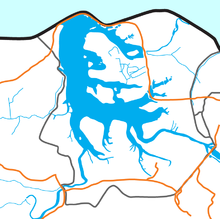
143:
123:
122:
120:
119:
118:
113:
112:53.383°N 6.183°E
109:
106:
105:
104:
101:
91:
65:
64:
58:
42:
30:
21:
864:
863:
859:
858:
857:
855:
854:
853:
799:
798:
783:
778:
777:
767:
765:
756:
755:
751:
741:
739:
731:
730:
726:
716:
714:
705:
704:
700:
690:
688:
679:
678:
674:
664:
662:
653:
652:
648:
638:
636:
627:
626:
622:
612:
610:
601:
600:
596:
580:
576:
566:
564:
563:on July 9, 2012
555:
554:
550:
540:
538:
527:
526:
522:
517:
504:Zuiderzee Works
495:
488:
477:
468:
465:
456:
450:
441:
432:
409:Schiermonnikoog
367:Kabinet-De Quay
292:
236:
202:
172: countries
142:Primary inflows
134:artificial lake
116:
114:
110:
107:
102:
99:
97:
95:
94:
76:
75:
74:
73:
72:
71:
70:
66:
45:
44:Satellite image
28:
23:
22:
15:
12:
11:
5:
862:
860:
852:
851:
846:
841:
836:
831:
826:
821:
816:
811:
801:
800:
797:
796:
782:
781:External links
779:
776:
775:
749:
724:
698:
687:. 11 June 1960
672:
646:
620:
594:
581:Buisman, Jan,
574:
548:
519:
518:
516:
513:
512:
511:
506:
501:
494:
491:
490:
489:
478:
471:
469:
466:
459:
457:
451:
444:
442:
433:
426:
291:
288:
228:
227:
224:
223:
220:
219:
216:
212:
211:
210:29 August 2000
208:
204:
203:
200:Ramsar Wetland
198:
195:
194:
191:
190:
185:
181:
180:
177:
176:
173:
166:
165:
160:
152:
151:
145:
137:
136:
131:
125:
124:
92:
86:
85:
82:
78:
77:
68:
67:
60:
59:
53:
52:
51:
50:
47:
46:
43:
35:
34:
26:
24:
14:
13:
10:
9:
6:
4:
3:
2:
861:
850:
847:
845:
842:
840:
837:
835:
832:
830:
827:
825:
822:
820:
817:
815:
812:
810:
807:
806:
804:
794:
789:
785:
784:
780:
763:
759:
753:
750:
738:. 27 May 1969
737:
734:
728:
725:
713:. 27 May 1969
712:
708:
702:
699:
686:
682:
676:
673:
660:
656:
650:
647:
635:. 4 June 1958
634:
630:
624:
621:
608:
604:
598:
595:
592:
588:
584:
578:
575:
562:
558:
557:"Lauwersmeer"
552:
549:
537:
535:
530:
529:"Lauwersmeer"
524:
521:
514:
510:
507:
505:
502:
500:
497:
496:
492:
486:
482:
475:
470:
463:
458:
455:
448:
443:
440:
436:
430:
425:
423:
420:
418:
414:
410:
406:
402:
401:national park
397:
395:
391:
387:
383:
378:
376:
372:
368:
364:
360:
355:
352:
347:
345:
341:
337:
333:
329:
325:
321:
317:
313:
304:
296:
289:
287:
285:
284:National Park
282:
278:
274:
269:
267:
263:
259:
255:
251:
247:
242:
234:
225:
221:
217:
209:
201:
192:
189:
186:
182:
178:
174:
171:
167:
164:
161:
159:
153:
149:
146:
144:
138:
135:
132:
130:
126:
121:
117:53.383; 6.183
93:
87:
83:
57:
48:
41:
36:
31:
19:
844:Het Hogeland
768:28 September
766:. Retrieved
761:
752:
742:28 September
740:. Retrieved
735:
727:
717:28 September
715:. Retrieved
710:
701:
691:28 September
689:. Retrieved
684:
675:
665:28 September
663:. Retrieved
658:
649:
639:28 September
637:. Retrieved
632:
623:
613:28 September
611:. Retrieved
606:
597:
582:
577:
565:. Retrieved
561:the original
551:
539:. Retrieved
532:
523:
421:
398:
379:
366:
358:
356:
348:
336:Dokkumerdiep
315:
309:
270:
266:birdwatching
232:
231:
793:Lauwersmeer
281:Lauwersmeer
246:Netherlands
233:Lauwersmeer
184:Settlements
175:Netherlands
115: /
90:Coordinates
69:Lauwersmeer
33:Lauwersmeer
803:Categories
515:References
485:Oostmahorn
481:lighthouse
454:Lauwersoog
452:Sluice at
439:Lauwersoog
417:Lauwersoog
413:Oostmahorn
394:Lauwersoog
386:canal lock
363:Leeuwarden
344:empoldered
338:, and the
316:Lauwerszee
273:Marnewaard
262:Wadden Sea
207:Designated
188:Marnewaard
163:Wadden Sea
18:Lauwerszee
567:August 2,
509:Zuider Ee
375:Friesland
371:Groningen
328:Friesland
324:Groningen
254:Friesland
250:Groningen
541:25 April
493:See also
388:. A new
332:Reitdiep
81:Location
392:called
390:harbour
382:sluices
320:Lauwers
290:History
148:Lauwers
100:53°23′N
589:
534:Ramsar
435:Sluice
403:. The
384:and a
334:, the
103:6°11′E
405:ferry
312:Dutch
170:Basin
150:River
770:2009
744:2009
719:2009
693:2009
667:2009
641:2009
615:2009
587:ISBN
569:2012
543:2018
479:The
373:and
326:and
258:dike
252:and
218:1247
129:Type
483:of
437:at
407:to
805::
760:.
709:.
683:.
657:.
631:.
605:.
585:,
531:.
419:.
340:Ee
314::
268:.
772:.
746:.
721:.
695:.
669:.
643:.
617:.
571:.
545:.
235:(
20:)
Text is available under the Creative Commons Attribution-ShareAlike License. Additional terms may apply.