271:
237:
517:
471:
190:
586:
35:
305:
397:
It was also during these times that townspeople within the
Hodgkinson goldfields fearful of Aborigines first experimented with a policy of 'pacification'. Local shop owner, John Byrnes, in 1882 brought a small group of Djungan peoples into town, feeding them meat and potatoes, and, soon, there were
444:
Queensland
Tourist and Travel Corporation (QTTC) had prepared and costed the feasibility of developing the tourism potential of Ngarrabullgan, and, by this time there was some genuine commercial interest in purchasing Kondoparinga property and Ngarrabullgan to enable a corporation operating out of
435:
Queensland
Tourist and Travel Corporation (QTTC) staff, followed by Sir Frank Moore (QTTC Chairman) and the Queensland Minister for Tourism, visited Ngarrabullgan and Kondoparinga Station (the pastoral property within which Ngarrabullgan sits)to see if a small tourist resort should be built, and
461:
expressing a strong wish to see
Ngarrabullgan sold to the Djungan peoples who had enjoyed free access to his property for many years. The other owner of the property, Skyfleet, wished to see the property sold to the Japanese owned consortium who were interested in developing the property's
323:(b) large diversity of well-preserved (intact) archaeological sites and features, some of which are directly associated with locally known initiation sites and places still sacred to the local Aboriginal peoples (both on top of the mountain and around the mountain's base);
394:. The Djungan peoples tell of how their grandparents had to flee from police and settlers, and by climbing Ngarrabullgan's escarpments they could sometimes escape the horses (some Djungan remember a cave on the south of the mountain where many were massacred and hidden).
326:(c) strong potential to yield new and important information about Aboriginal occupation, use, beliefs and lifestyles from the Pleistocene down to the present (especially as new archaeological techniques are developed and combined with further, ongoing research and study);
151:
The tabletop mountain is a monolith bounded by high cliffs (or escarpments) that fall 200 to 400 m to the surrounding
Hodgkinson Basin, making it an impressive natural monument which is regarded by the local Djungan Aboriginal peoples to be a sacred 'Dreaming' place (see
410:
had burrowed its way into the side of
Ngarrabullgan, much to the fear of the Djungan Aboriginal peoples. On 19 September 1921 there was a huge explosion killing 75 people in what turned out to be Queensland's worst mining disaster (see also
329:(d) excellent examples of the rock art and resource use of those Aboriginal peoples who have occupied and used the area for many generations and still, to this day, view the mountain as a major spiritual site at the heart of their country;
524:
of
Environment had sought to excise Ngarrabullgan from the property at the time of purchase, but, at the last moment, a binding agreement was negotiated and agreed to see Ngrrabullgan remain part of the property and later declared a
287:
8 frog species, 55 reptile species, 99 bird species and 20 mammal species; 22 of which are species of special conservation significance under either the
Queensland or Australian biodiversity conservation statutory regimes.
332:(e) considerable aesthetic impact combining an impressive physical presence as a large natural monument, together with natural and cultural features valuable to the Djungan peoples, other Aboriginal peoples, the people of
756:"New optical and radiocarbon dates from Ngarrabullgan Cave, a Pleistocene archaeological site in Australia : implications for the comparability of time clocks and for human colonization of Australia"
380:
lands an outstanding landmark on the
Hodgkinson is a massive wall of rock overlooking 'Mulligan's goldfield'. A meeting-place of the aborigines from time immemorial, it has seen the passing of a thousand
418:
By 1990 the coal mine had long been closed (since 1957); the mining towns had all broken down and been deserted; and the cattle-properties were profitless, run down with rubber-vine, feral pigs and
174:, and, together, the many 'archaeological' caves and rockshelters found in and around Ngarrabullgan constitutes Queensland's greatest density of known sites dating back more than 4,000 years BP.
365:
Prior to gold rushes and the associated occupation of the
Hodgkinson River area, Ngarrabullgin was a place of some spiritual and ceremonial significance to the Djungan Aboriginal peoples.
799:
Sediment Mixing at Nonda Rock: Investigations of Stratigraphic Integrity at an Early Archaeological Site in Northern Australia and Implications for the Human Colonisation of the Continent
348:
For similar reasons the Queensland Government formally registered Ngarrabullgan as "The Mount Mulligan Aboriginal Cultural Heritage Area" under its Aboriginal heritage legislation (
386:
During and following the Hodgkinson River gold rush of 1876, the local Djungan population was decimated and the survivors were drawn to the fringes of mining settlements formed at
1049:
507:
the Australian Government (i.e. Aboriginal and Torres Strait Islander Commission) approved the purchase of Kondoparinga property, and Ngarrabullgan, for the Djungan people.
177:
The combination of impressive natural feature, Aboriginal beliefs and mythologies, and archaeological sites of such antiquity make Ngarrabullgan the oldest known and dated
780:
698:
159:
On the tabletop itself are found the two oldest-known Aboriginal sites in Queensland: Nonda Rock and Ngarrabullgan Cave. Here Aboriginal cultural deposits have been
784:
501:, to re-unite and form the Kuku Djungan Aboriginal Corporation; to raise the pan-Australian Aboriginal flag; and to resolve to regain ownership of Ngarrabullgan.
1039:
1054:
301:
The Australian Heritage Commission included Ngarrabullgan on its register of the National Estate on 24 June 1997, describing it as a place that holds:
1044:
678:
1059:
436:
tourist enterprise developed within the vicinity of Ngarrabullgan, offering tourists an 'experience' of the mountain and surrounding heritage.
990:
739:
556:
are still seeking to see Ngarrabullgin declared a National Park with a majority Djungan board of management, as agreed back in December 1991.
513:
Kondoparinga had been purchased, and the Djungan peoples had regained ownership of Ngarrabullgan. Queensland Government's Department
415:). To the Djungan people this was retribution for disturbing the sacred mountain in which dwelt a 'white horse' and the spirit Eekoo.
888:
Report to A.N.P.W.S and the Kuku Djungan Aboriginal Corporation on the Ngarrabullgan Heritage Survey Project: 21 May - 31 August 1993
224:
uplift the original arenite surrounding the deposits eroded away leaving Ngarrabullgan as a free-standing conglomerate and sandstone
457:
The person occupying Kondoparinga pastoral property and joint owner of the property (Mr Reg Adams) approached people then living in
164:
964:
WHITE, M & HELBER, L (1988) Mount Mulligan Tourist Project. Report to the Queensland Travel and Tourist Corporation. Brisbane.
1029:
550:
have nominated the mountain to be declared an Indigenous Protected Area under the Australian Government's protected area program
266:
Studies of both Ngarrabullgan's eucalypt forests and its surrounding woodlands identified 13 distinct land units supporting:
156:), and features in the mythological legends and beliefs of other Aboriginal groups for hundreds of kilometres around.
1034:
822:
797:
DAVID, B.; ROBERTS, R.G.; MAGEE, J.; MIALANES, J.; TURNEY, C.; BIRD, M.; WHITE, C.; FIFIELD, L.K. & TIBBY, J. (2007)
827:
412:
281:
10 plant species that are considered either rare or threatened, including 8 plant species that are found nowhere else.
422:. Ngarrabullgan, however, still stood to become the focus of a Djungan Aboriginal people's 'cultural renaissance'.
17:
547:
have registered the mountain with the Australian Heritage Commission to form part of Australia's 'National Estate'
446:
387:
209:) of the Hodgkinson Basin. Successive layers of sediment were deposited into this rift filling it first with
565:
Published archaeological sites (listed in rough geographical order, generally running from north to south).:
259:, with a well-developed understory. These tabletop forests contrast, noticeably, with the open sclerophyll
101:
832:
706:
486:
544:
have ownership of the mountain and developed management plans for its future protection and management;
181:
in Queensland, and a place of state, national and international interest and scientific significance.
936:
553:
have seen the mountain declared an 'Aboriginal cultural heritage area' under Queensland legislation.
312:(a) important evidence enhancing the Australian communities' knowledge of Aboriginal occupation of
171:
754:
David, Bruno; Roberts, Richard G; Tuniz, C. (Claudio); Jones, Rhys, 1941-2001; Head, John (1997),
178:
774:
735:
170:
Other ancient Aboriginal rockshelter sites on the mountain have been dated to the end of the
337:
202:
371:
in his far north Queensland gold prospecting story, wrote about Ngarrabullgan as follows:
270:
236:
449:
to offer tourists and visitors an exciting, authentic 'outback Queensland' experience. .
201:(running in a general south-east to north-west direction) within the deformed and folded
906:. Unpublished report to the Aboriginal and Torres Strait Islander Commission, Canberra.
666:
407:
391:
84:
1023:
526:
516:
470:
189:
924:. Report to the Commonwealth Department of Heritage and Water, Canberra. Page 31.
244:
The vegetation on the Ngarrabullgan tabletop (plateau) has been described as wet
899:
883:
732:
Landscapes, rock-art, and the dreaming : an archaeology of preunderstanding
368:
313:
245:
160:
585:
34:
490:
256:
144:
73:
1005:
992:
494:
377:
252:
217:
153:
77:
937:
PDF of Queensland Government Map of 'Mount Mulligan Cultural Heritage Area'
304:
854:
Geology of the Hodgkinson Formation in the Mount Mulligan 1:100 Sheet Area
755:
106:
18 km long, 6.5 km wide sandstone conglomerate tabletop mountain
975:
Hand Shelter (Ngarrabullgan), Cape York Peninsula, Australia: site report
482:
317:
260:
221:
214:
136:
520:
Kuku Djungan raise flag and resolve to regain ownership of Ngarrabullgan
498:
458:
333:
210:
206:
419:
248:
225:
140:
69:
50:
406:
By 1921 the Hodgkinson gold fields had declined, and a coal mine at
398:
150 Aborigines living in a camp just 8 km from Ngarrabullgan.
679:
Map of Mount Mulligan Registered Aboriginal Cultural Heritage Area
584:
515:
469:
303:
269:
235:
188:
198:
139:(18 km by 6.5 km) located 100 kilometres west of
55:
400 m (1,300 ft)above surrounding hills and plains
922:
The Indigenous Protected Area's Programme 2006 Evalutation
852:
HALFPENNY, R.W; DONCHAK, P.J.T; & HEGARTY, R.A (1987)
529:
to be managed by a majority Djungan board of management
197:
The mountain was originally formed in a narrow faulted
91:
Featherbed Ranges, between Mitchell & Walsh Rivers
904:
Archaeology of Mount Mulligan: A Quick Reconnaissance
213:
coal (at its base), then Permian conglomerates, with
481:over 150 Djungan people had travelled from Cairns,
100:
95:
83:
64:
59:
49:
44:
27:
340:region more generally, and Australia as a whole.
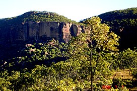
39:View of Ngarrabullgan escarpment from the east
8:
1050:Cultural landscapes of North-East Queensland
779:: CS1 maint: multiple names: authors list (
960:
958:
263:of the surrounding hills and plains below.
932:
930:
879:
877:
875:
873:
871:
869:
867:
865:
863:
861:
783:) CS1 maint: numeric names: authors list (
725:
723:
344:Queensland Register of Aboriginal Heritage
24:
699:"Mount Mulligan – mountain (entry 39750)"
589:Ngarrabullgan Rockshelter Excavation Site
916:
914:
912:
817:
815:
813:
811:
690:
474:Kuku Djungan people gather 27 July 1991
772:
68:Hodgkinson River, 100 km west of
7:
952:. Angus and Robertsson. Sydney: 105.
1040:Archaeological sites in Queensland
167:(OSL), back to 40,000+ years ago.
135:by the State, is a large tabletop
14:
1055:Australian National Heritage List
165:optically stimulated luminescence
762:, vol. 71, pp. 183–188
350:Aboriginal Cultural Heritage Act
33:
16:For the former mining town, see
1045:Australian Aboriginal mythology
462:identified tourism potential.:
297:Register of the National Estate
240:Ngarrabullgan vegetation on top
734:, Leicester University Press,
308:Rock art site on Ngarrabullgan
274:Ngarrabullgan vegetation below
28:Ngarrabullgan (Mount Mulligan)
1:
1060:Sacred mountains of Australia
803:Journal of Quaternary Science
828:Australian Heritage Database
413:Mount Mulligan mine disaster
193:Ngarrabullgan from the north
1076:
402:Mount Mulligan coal mining
361:Hodgkinson River gold-rush
18:Mount Mulligan, Queensland
15:
32:
1030:Mountains of Queensland
948:IDRIESS, Ion L. (1958)
920:GILLIGAN, Brian (2007)
805:Volume 22. pp. 449–479.
1006:16.86667°S 144.75000°E
981:. Volume 25. Number 1.
703:Queensland Place Names
590:
521:
475:
384:
376:"Farther out in those
309:
275:
241:
194:
833:Australian Government
730:David, Bruno (2002),
707:Queensland Government
588:
519:
473:
373:
352:2006 (Qld)) in 2006.
307:
273:
239:
192:
1035:Far North Queensland
1011:-16.86667; 144.75000
973:DAVID, Bruno (2002)
605:Quinine Bush Shelter
561:Archaeological sites
540:The Djungan people:
426:Cultural Renaissance
163:dated, and dated by
131:), officially named
1002: /
575:Gorge Creek Shelter
635:Grass Tree Shelter
595:Ngarrabullgan Cave
591:
522:
476:
310:
276:
242:
195:
179:cultural landscape
45:Highest point
823:"Place ID 100267"
741:978-0-7185-0243-0
110:
109:
1067:
1017:
1016:
1014:
1013:
1012:
1007:
1003:
1000:
999:
998:
995:
982:
971:
965:
962:
953:
946:
940:
934:
925:
918:
907:
897:
891:
881:
856:
850:
844:
843:
841:
839:
819:
806:
795:
789:
788:
778:
770:
769:
767:
751:
745:
744:
727:
718:
717:
715:
713:
695:
655:Bush Peg Shelter
625:Fig Tree Shelter
620:Dragonfly Hollow
338:North Queensland
203:metamorphic rock
143:in the north of
87:
37:
25:
1075:
1074:
1070:
1069:
1068:
1066:
1065:
1064:
1020:
1019:
1010:
1008:
1004:
1001:
996:
993:
991:
989:
988:
986:
985:
972:
968:
963:
956:
947:
943:
935:
928:
919:
910:
898:
894:
882:
859:
851:
847:
837:
835:
821:
820:
809:
796:
792:
771:
765:
763:
753:
752:
748:
742:
729:
728:
721:
711:
709:
697:
696:
692:
687:
675:
663:
650:Tunnell Shelter
640:Lookout Shelter
610:Kookaburra Rock
570:Initiation Cave
563:
535:
468:
455:
442:
433:
428:
404:
363:
358:
346:
299:
294:
292:Heritage status
267:
234:
232:Flora and fauna
187:
148:
85:
40:
21:
12:
11:
5:
1073:
1071:
1063:
1062:
1057:
1052:
1047:
1042:
1037:
1032:
1022:
1021:
984:
983:
966:
954:
950:Back O' Cairns
941:
926:
908:
892:
857:
845:
807:
790:
746:
740:
719:
689:
688:
686:
683:
682:
681:
674:
673:External links
671:
670:
669:
667:Mount Mulligan
662:
659:
658:
657:
652:
647:
642:
637:
632:
627:
622:
617:
615:Courtyard Rock
612:
607:
602:
597:
583:
582:
580:Waterhole Cave
577:
572:
562:
559:
558:
557:
554:
551:
548:
545:
534:
531:
467:
464:
454:
451:
441:
438:
432:
429:
427:
424:
408:Mount Mulligan
403:
400:
392:Mount Mulligan
362:
359:
357:
354:
345:
342:
298:
295:
293:
290:
251:, mainly of a
233:
230:
186:
183:
133:Mount Mulligan
108:
107:
104:
98:
97:
93:
92:
89:
81:
80:
66:
62:
61:
57:
56:
53:
47:
46:
42:
41:
38:
30:
29:
13:
10:
9:
6:
4:
3:
2:
1072:
1061:
1058:
1056:
1053:
1051:
1048:
1046:
1043:
1041:
1038:
1036:
1033:
1031:
1028:
1027:
1025:
1018:
1015:
980:
976:
970:
967:
961:
959:
955:
951:
945:
942:
938:
933:
931:
927:
923:
917:
915:
913:
909:
905:
901:
896:
893:
889:
885:
880:
878:
876:
874:
872:
870:
868:
866:
864:
862:
858:
855:
849:
846:
834:
830:
829:
824:
818:
816:
814:
812:
808:
804:
800:
794:
791:
786:
782:
776:
761:
757:
750:
747:
743:
737:
733:
726:
724:
720:
708:
704:
700:
694:
691:
684:
680:
677:
676:
672:
668:
665:
664:
660:
656:
653:
651:
648:
646:
643:
641:
638:
636:
633:
631:
630:Hand Shelter:
628:
626:
623:
621:
618:
616:
613:
611:
608:
606:
603:
601:
598:
596:
593:
592:
587:
581:
578:
576:
573:
571:
568:
567:
566:
560:
555:
552:
549:
546:
543:
542:
541:
539:
532:
530:
528:
527:National Park
518:
514:
512:
508:
506:
502:
500:
496:
492:
488:
484:
480:
472:
465:
463:
460:
452:
450:
448:
439:
437:
430:
425:
423:
421:
416:
414:
409:
401:
399:
395:
393:
389:
383:
382:
379:
372:
370:
366:
360:
355:
353:
351:
343:
341:
339:
335:
330:
327:
324:
321:
319:
315:
306:
302:
296:
291:
289:
286:
282:
280:
272:
268:
264:
262:
258:
254:
250:
247:
238:
231:
229:
227:
223:
219:
216:
212:
208:
204:
200:
191:
185:Geomorphology
184:
182:
180:
175:
173:
168:
166:
162:
157:
155:
149:
146:
142:
138:
134:
130:
129:Nguddaboolgan
126:
125:Ngarrabullgin
122:
118:
114:
113:Ngarrabullgan
105:
103:
102:Mountain type
99:
94:
90:
88:
82:
79:
75:
71:
67:
63:
58:
54:
52:
48:
43:
36:
31:
26:
23:
19:
987:
979:The Artefact
978:
974:
969:
949:
944:
921:
903:
895:
887:
853:
848:
836:. Retrieved
826:
802:
798:
793:
764:, retrieved
759:
749:
731:
710:. Retrieved
702:
693:
654:
649:
644:
639:
634:
629:
624:
619:
614:
609:
604:
599:
594:
579:
574:
569:
564:
537:
536:
523:
510:
509:
504:
503:
478:
477:
456:
447:Port Douglas
443:
434:
417:
405:
396:
388:Thornborough
385:
375:
374:
367:
364:
349:
347:
331:
328:
325:
322:
311:
300:
284:
283:
278:
277:
265:
243:
220:above. With
196:
176:
172:last ice age
169:
158:
150:
147:(Australia).
132:
128:
124:
121:Nurrabullgan
120:
116:
112:
111:
86:Parent range
22:
1009: /
997:144°45′00″E
645:Painted Ell
369:Ion Idriess
336:Shire, the
314:Pleistocene
255:species of
246:sclerophyll
161:radiocarbon
117:Njrrabulgan
1024:Categories
994:16°52′00″S
838:29 October
766:17 October
685:References
600:Nonda Rock
491:Townsville
257:Eucalyptus
218:sandstones
145:Queensland
74:Queensland
760:Antiquity
538:November:
511:December:
495:Chillagoe
487:Innisfail
378:Chillagoe
316:into the
253:bloodwood
154:Dreamtime
78:Australia
60:Geography
51:Elevation
900:CRIBB, R
775:citation
661:See also
483:Yarrabah
479:27 July:
420:brumbies
381:tribes."
318:Holocene
261:woodland
222:tectonic
215:Triassic
137:mountain
65:Location
902:(1990)
886:(1993)
884:CRIBB,R
712:22 June
505:August:
499:Mareeba
459:Mareeba
356:History
334:Mareeba
249:forests
211:Permian
207:arenite
96:Geology
738:
285:Fauna:
279:Flora:
226:massif
141:Cairns
115:(also
70:Cairns
127:, or
840:2007
785:link
781:link
768:2019
736:ISBN
714:2017
533:2007
497:and
466:1991
453:1990
440:1988
431:1986
390:and
199:rift
1026::
977:.
957:^
929:^
911:^
860:^
831:.
825:.
810:^
801:.
777:}}
773:{{
758:,
722:^
705:.
701:.
493:,
489:,
485:,
320:;
228:.
123:,
119:,
76:,
72:,
939:.
890:.
842:.
787:)
716:.
205:(
20:.
Text is available under the Creative Commons Attribution-ShareAlike License. Additional terms may apply.