50:
1017:
34:
57:
197:
352:
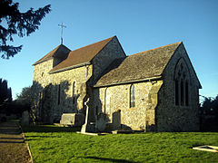
St Mary's Parish Church nave dates back to Saxon times: the chancel and tower are from the 13th century and the church was restored in 1873. The patronage of the parish rested with the lord of the manor of
Sullington until 1938, when Evelyn Palmer
452:"Sullington: Church Pages 27-29 A History of the County of Sussex: Volume 6 Part 2, Bramber Rape (North-Western Part) Including Horsham. Originally published by Victoria County History, London, 1986"
237:
133:
221:
1082:
1058:
88:
471:"Sullington: Manors and other estates Pages 20-24 A History of the County of Sussex: Volume 6 Part 2, Bramber Rape (North-Western Part) Including Horsham"
996:
1092:
377:
49:
214:
209:
226:
281:
1051:
530:
1077:
408:
263:
169:
980:
273:
81:
1044:
322:
105:
1087:
268:
810:
775:
770:
338:
183:
955:
940:
790:
720:
615:
245:
361:. The Victorian rectory (built c1845) was sold off as a private residence and later occupied by the writer
915:
590:
730:
690:
580:
523:
358:
345:. In 1961 the parish had a population of 1354. On 1 April 2003 the parish was abolished and merged with
372:
Sullington Manor, on
Sullington Lane, is a Grade II listed former farmhouse. The manor was held by the
880:
845:
660:
595:
366:
115:
1016:
975:
830:
815:
326:
159:
151:
123:
920:
470:
451:
850:
700:
630:
384:
950:
635:
540:
516:
404:
373:
354:
835:
498:
1028:
960:
800:
785:
429:
376:
family from the dissolution of the monasteries (1546) until 1789, when it was sold to
1071:
925:
780:
755:
605:
202:
930:
825:
750:
740:
650:
640:
318:
97:
508:
33:
1024:
945:
900:
875:
805:
765:
655:
610:
600:
346:
330:
141:
70:
965:
895:
890:
840:
665:
362:
296:
283:
760:
725:
715:
695:
575:
334:
910:
885:
865:
820:
795:
745:
705:
620:
585:
559:
970:
935:
860:
735:
710:
685:
680:
675:
670:
645:
625:
554:
342:
175:
870:
855:
503:
387:, which is a woodland area popular among visitors to Sullington.
512:
499:
Official
Storrington & Sullington Parish Council Website
1032:
405:"Population statistics Sullington CP/AP through time"
989:
568:
547:
236:
220:
208:
196:
182:
168:
150:
132:
114:
96:
80:
26:
1052:
524:
8:
369:. The modern rectory is on Washington Road.
1059:
1045:
997:List of civil parishes in Horsham district
531:
517:
509:
23:
349:to form "Storrington & Sullington".
396:
235:
191:
167:
79:
30:
341:road, 20 miles (32 km) south of
219:
207:
195:
181:
149:
131:
113:
7:
1083:Former civil parishes in West Sussex
1013:
1011:
378:George Wyndham, 3rd Earl of Egremont
333:, England. The village lies on the
56:
14:
1015:
430:"Worthing Registration District"
409:A Vision of Britain through Time
55:
48:
32:
16:Village in West Sussex, England
1:
1031:. You can help Knowledge by
1093:West Sussex geography stubs
82:OS grid reference
21:Human settlement in England
1109:
1010:
323:Storrington and Sullington
106:Storrington and Sullington
254:
232:
192:
43:
31:
317:is a village and former
1078:Villages in West Sussex
956:West Chiltington Common
321:, now in the parish of
246:Arundel and South Downs
1027:location article is a
475:British History Online
456:British History Online
359:Diocese of Chichester
569:Villages and hamlets
367:Lady Cynthia Asquith
297:50.90685°N 0.43882°W
184:Sovereign state
365:and the politician
357:) passed it to the
293: /
302:50.90685; -0.43882
238:UK Parliament
1040:
1039:
1005:
1004:
631:Broadbridge Heath
504:Community website
385:Sullington Warren
312:
311:
134:Shire county
38:Church of St Mary
1100:
1088:Horsham District
1061:
1054:
1047:
1019:
1012:
951:West Chiltington
636:Broadford Bridge
541:Horsham District
539:Settlements in
533:
526:
519:
510:
486:
485:
483:
481:
466:
460:
459:
448:
442:
441:
439:
437:
426:
420:
419:
417:
415:
401:
308:
307:
305:
304:
303:
298:
294:
291:
290:
289:
286:
260:
227:South East Coast
178:
92:
91:
69:Location within
59:
58:
52:
36:
24:
1108:
1107:
1103:
1102:
1101:
1099:
1098:
1097:
1068:
1067:
1066:
1065:
1008:
1006:
1001:
985:
921:Tisman's Common
836:Partridge Green
564:
543:
537:
495:
490:
489:
479:
477:
468:
467:
463:
450:
449:
445:
435:
433:
428:
427:
423:
413:
411:
403:
402:
398:
393:
301:
299:
295:
292:
287:
284:
282:
280:
279:
278:
258:
250:
174:
164:
146:
128:
110:
87:
86:
76:
75:
74:
73:
67:
66:
65:
64:
60:
39:
22:
17:
12:
11:
5:
1106:
1104:
1096:
1095:
1090:
1085:
1080:
1070:
1069:
1064:
1063:
1056:
1049:
1041:
1038:
1037:
1020:
1003:
1002:
1000:
999:
993:
991:
990:Civil parishes
987:
986:
984:
983:
978:
973:
968:
963:
961:West Grinstead
958:
953:
948:
943:
938:
933:
928:
923:
918:
913:
908:
903:
898:
893:
888:
883:
878:
873:
868:
863:
858:
853:
848:
843:
838:
833:
828:
823:
818:
813:
808:
803:
798:
793:
788:
786:Mannings Heath
783:
778:
773:
768:
763:
758:
753:
748:
743:
738:
733:
728:
723:
718:
713:
708:
703:
701:Dragon's Green
698:
693:
688:
683:
678:
673:
668:
663:
658:
653:
648:
643:
638:
633:
628:
623:
618:
613:
608:
603:
598:
593:
588:
583:
578:
572:
570:
566:
565:
563:
562:
557:
551:
549:
545:
544:
538:
536:
535:
528:
521:
513:
507:
506:
501:
494:
493:External links
491:
488:
487:
461:
443:
421:
395:
394:
392:
389:
355:Lady Caldecott
310:
309:
277:
276:
271:
266:
261:
259:List of places
255:
252:
251:
249:
248:
242:
240:
234:
233:
230:
229:
224:
218:
217:
212:
206:
205:
200:
194:
193:
190:
189:
188:United Kingdom
186:
180:
179:
172:
166:
165:
163:
162:
156:
154:
148:
147:
145:
144:
138:
136:
130:
129:
127:
126:
120:
118:
112:
111:
109:
108:
102:
100:
94:
93:
84:
78:
77:
68:
62:
61:
54:
53:
47:
46:
45:
44:
41:
40:
37:
29:
28:
20:
15:
13:
10:
9:
6:
4:
3:
2:
1105:
1094:
1091:
1089:
1086:
1084:
1081:
1079:
1076:
1075:
1073:
1062:
1057:
1055:
1050:
1048:
1043:
1042:
1036:
1034:
1030:
1026:
1021:
1018:
1014:
1009:
998:
995:
994:
992:
988:
982:
979:
977:
974:
972:
969:
967:
964:
962:
959:
957:
954:
952:
949:
947:
944:
942:
939:
937:
934:
932:
929:
927:
926:Upper Beeding
924:
922:
919:
917:
914:
912:
909:
907:
904:
902:
899:
897:
894:
892:
889:
887:
884:
882:
879:
877:
874:
872:
869:
867:
864:
862:
859:
857:
854:
852:
849:
847:
844:
842:
839:
837:
834:
832:
829:
827:
824:
822:
819:
817:
814:
812:
809:
807:
804:
802:
799:
797:
794:
792:
789:
787:
784:
782:
781:Lower Beeding
779:
777:
774:
772:
769:
767:
764:
762:
759:
757:
756:Kilnwood Vale
754:
752:
749:
747:
744:
742:
739:
737:
734:
732:
729:
727:
724:
722:
719:
717:
714:
712:
709:
707:
704:
702:
699:
697:
694:
692:
689:
687:
684:
682:
679:
677:
674:
672:
669:
667:
664:
662:
659:
657:
654:
652:
649:
647:
644:
642:
639:
637:
634:
632:
629:
627:
624:
622:
619:
617:
614:
612:
609:
607:
606:Billingshurst
604:
602:
599:
597:
594:
592:
589:
587:
584:
582:
579:
577:
574:
573:
571:
567:
561:
558:
556:
553:
552:
550:
546:
542:
534:
529:
527:
522:
520:
515:
514:
511:
505:
502:
500:
497:
496:
492:
476:
472:
465:
462:
457:
453:
447:
444:
431:
425:
422:
410:
406:
400:
397:
390:
388:
386:
383:A feature is
381:
379:
375:
370:
368:
364:
360:
356:
350:
348:
344:
340:
336:
332:
328:
324:
320:
316:
306:
275:
272:
270:
267:
265:
262:
257:
256:
253:
247:
244:
243:
241:
239:
231:
228:
225:
223:
216:
213:
211:
204:
201:
199:
187:
185:
177:
173:
171:
161:
158:
157:
155:
153:
143:
140:
139:
137:
135:
125:
122:
121:
119:
117:
107:
104:
103:
101:
99:
95:
90:
85:
83:
72:
51:
42:
35:
25:
19:
1033:expanding it
1022:
1007:
931:Warminghurst
905:
826:Old Holbrook
751:Itchingfield
741:Heath Common
651:Codmore Hill
641:Brooks Green
480:22 September
478:. Retrieved
474:
469:Baggs, A P.
464:
455:
446:
434:. Retrieved
424:
412:. Retrieved
399:
382:
371:
351:
337:west of the
329:district of
319:civil parish
314:
313:
98:Civil parish
18:
1025:West Sussex
981:Woodmancote
946:Watersfield
901:Storrington
876:Shermanbury
811:North Stoke
806:North Heath
801:Monk's Gate
776:Littleworth
771:Littlehaven
766:Lambs Green
656:Coldwaltham
611:Bines Green
601:Barns Green
347:Storrington
331:West Sussex
300: /
274:West Sussex
215:West Sussex
142:West Sussex
71:West Sussex
1072:Categories
966:Wiggonholt
941:Washington
906:Sullington
896:Southwater
891:Small Dole
841:Pulborough
791:Maplehurst
721:Gay Street
666:Coneyhurst
616:Blackstone
391:References
363:A J Cronin
315:Sullington
285:50°54′25″N
160:South East
63:Sullington
27:Sullington
916:The Haven
816:Nutbourne
761:Kingsfold
726:Graylands
716:Five Oaks
696:Dial Post
591:Ashington
586:Annington
576:Adversane
335:A283 road
325:, in the
288:0°26′20″W
222:Ambulance
911:Thakeham
886:Slinfold
866:Rudgwick
821:Nuthurst
796:Marehill
746:Henfield
731:Greatham
706:Edburton
691:Crabtree
621:Botolphs
581:Amberley
560:Steyning
116:District
89:TQ099131
971:Wineham
936:Warnham
881:Shipley
861:Rowhook
846:Rackham
736:Hardham
711:Faygate
686:Cowfold
681:Copsale
676:Cootham
671:Coolham
661:Colgate
646:Buncton
626:Bramber
596:Ashurst
555:Horsham
432:. UKBMD
374:Shelley
343:Horsham
327:Horsham
269:England
176:England
170:Country
124:Horsham
976:Wiston
871:Rusper
856:Roffey
831:Parham
436:12 May
414:12 May
203:Sussex
198:Police
152:Region
1023:This
548:Towns
1029:stub
851:Rock
482:2021
438:2023
416:2023
210:Fire
380:.
339:A24
1074::
473:.
454:.
407:.
264:UK
1060:e
1053:t
1046:v
1035:.
532:e
525:t
518:v
484:.
458:.
440:.
418:.
353:(
Text is available under the Creative Commons Attribution-ShareAlike License. Additional terms may apply.