581:
505:
164:
1141:
42:
729:, which has become a popular wedding venue and also offers a range of sports and facilities including badminton and a state of the art 3G football pitch. The facility was built in 1996, and is home to Thurmaston Parish Council Offices. Elizabeth Park is also host to many of the local communities sports teams, such as Thurmaston DPC FC, Thurmaston Magpies FC and Thurmaston Bowls club.
777:
887:
151:
904:
879:
862:
171:
675:
951:
349:
716:, whose members help promote an interest in different aspects of both past and present village life. One particular activity being pursued by a member of the group is the creation of an online virtual war memorial. The
1026:
1094:
550:, which by-passes the main village. To the east of the road is the mostly residential, newer part of Thurmaston. To the west is the main village on Melton Road, which stands on the old
389:
253:
693:
superstore out of business. The
Thurmaston Shopping Centre, featuring a number of retail outlets and restaurants, was built on the site of the old Co-op superstore in 2005.
696:
The main village stretch, along Melton Road, has several pubs, takeaway food outlets, convenience stores and various other small retail establishments. The head offices of
366:
373:
821:
1087:
210:
700:
are also located in the village, along with Arriva's
Thurmaston depot where the majority of their buses and drivers that operate in Leicester are based.
540:
703:
As well as many other industrial sites along Melton Road, Thurmaston also contains the Earls Way
Industrial Estate in the eastern half of the village.
1373:
580:
1080:
722:
are being compiled to provide a listing of all those from the village who served their country in the Great War of 1914-1918 and the 1939-1945 War.
335:
163:
397:
433:
1368:
361:
814:
737:
Thurmaston has numerous landmarks, the most famous of which being the Church Hill Road Bridge which is notorious for its flooding.
125:
425:
415:
378:
323:
289:
682:
Thurmaston's prominent location on the edge of
Leicester has seen much development in recent years. On 31 March 2003, a large
662:, which takes in students from all the aforementioned schools in the village, as well as schools in the neighbouring town of
63:
1378:
807:
761:. Charnwood borough council's local transport plan from 2004 proposed new railway stations to be opened at Thurmaston and
690:
203:
106:
78:
543:
in 1894. In 1935, the district was annexed to the city of
Leicester where it took its modern-day name of Rushey Mead.
59:
24:
1226:
482:
85:
52:
1311:
1001:
470:
420:
1165:
871:
841:
517:
504:
303:
1261:
92:
1155:
851:
846:
567:
513:
539:
Rushey Mead was formerly part of the
Thurmaston parish in the 19th century, before becoming a Thurmaston
1342:
1180:
659:
607:
603:
354:
74:
987:
973:
1104:
478:
243:
235:
1301:
1221:
566:
are located there, one of which is also a boat-yard, and numerous mooring sites. These lead to the
1072:
271:
591:
Aeroplanes Ltd., a subsidiary based in
Thurmaston, developed the Taylorcraft Model 'D' and the
746:
599:
574:
1160:
328:
1316:
1251:
1140:
750:
697:
618:
592:
99:
785:
474:
261:
184:
1362:
1337:
1276:
893:
529:
279:
1062:
1286:
1256:
1236:
1170:
1119:
762:
712:
555:
219:
718:
1296:
1175:
923:
918:
913:
799:
781:
655:
637:
633:
611:
588:
533:
41:
1291:
686:
595:
Mk. I through Mk. V, which became the backbone aircraft of the
British A.O.P.
559:
28:
20:
448:
435:
1347:
1321:
1281:
754:
630:
551:
547:
493:
489:
313:
150:
1271:
1231:
1125:
710:
which is published bi-monthly. The village has a local history society,
1266:
1241:
1185:
674:
295:
1306:
1211:
1190:
1130:
789:
776:
758:
663:
563:
525:
521:
1246:
1216:
1057:
673:
579:
503:
683:
1076:
803:
650:
Church Hill Infant School and Church Hill C of E Junior School
35:
1067:
745:
Thurmaston is served by a number of bus companies including
1007:. Charnwood Borough Council Local Plan. 2004. p. 135
1002:"Chapter 7: Transport and Traffic Management, Rail 7.65"
621:
1027:"Borough of Charnwood Local Plan(2004)–Saved Policies"
488:
It is situated four miles north of the city centre of
1330:
1204:
1148:
1111:
765:. This has since been removed from the local plan.
577:also runs through the eastern half of the village.
388:
372:
360:
348:
334:
322:
312:
302:
288:
270:
252:
234:
218:
202:
194:
143:
66:. Unsourced material may be challenged and removed.
689:opened on Barkby Thorpe Lane, pushing the nearby
536:and the boundaries of the Leicester urban area.
725:The village also has its own community centre,
558:. Thurmaston lies on the eastern banks of the
1088:
815:
8:
1095:
1081:
1073:
952:"Neighbourhood statistics - Thurmaston CP"
822:
808:
800:
727:Elizabeth Park Sports and Community Centre
140:
617:The Thurmaston depot and headquarters of
570:which is a purpose-built nature reserve.
126:Learn how and when to remove this message
943:
387:
343:
311:
287:
201:
147:
678:St Michael’s & All Angels’ Church
512:Thurmaston is bounded to the west by
371:
359:
347:
333:
321:
301:
269:
251:
233:
7:
1063:Thurmaston @ Leicestershire Villages
837:
757:. The nearest railway station is in
644:Bishop Ellis Catholic Primary School
64:adding citations to reliable sources
706:The village has its own newspaper,
974:"The Co-op is in for a rough ride"
546:Thurmaston is split in two by the
170:
16:Village in Leicestershire, England
14:
554:, the historic road built by the
1374:Civil parishes in Leicestershire
1139:
954:. Office for national statistics
902:
885:
877:
860:
775:
508:The Top House pub on Melton Road
485:, it had a population of 9,668.
169:
162:
149:
40:
990:. The Grocer. 15 November 2003.
496:, Leicester's outer ring road.
51:needs additional citations for
477:, England, located within the
1:
903:
861:
830:Places adjacent to Thurmaston
886:
878:
976:. The Grocer. 8 March 2003.
719:Thurmaston Military Indexes
204:OS grid reference
138:Human settlement in England
1395:
1369:Villages in Leicestershire
1103:Towns and villages of the
629:Thurmaston contains three
492:and lies just outside the
18:
1137:
1058:Thurmaston Parish Council
1034:Charnwood Borough Council
835:
713:Thurmaston Heritage Group
532:. South of Thurmaston is
406:
384:
344:
157:
148:
647:Eastfield Primary School
19:Not to be confused with
1262:Ratcliffe on the Wreake
988:"Blighted co-op closes"
584:Melton Road, Thurmaston
679:
606:, once boasted former
585:
568:Watermead Country Park
514:Watermead Country Park
509:
324:Postcode district
677:
660:The Roundhill Academy
608:England international
583:
548:A607 dual carriageway
507:
500:History and geography
1379:Borough of Charnwood
1105:Borough of Charnwood
708:The Thurmaston Times
479:Borough of Charnwood
304:Sovereign state
60:improve this article
1302:Walton on the Wolds
1222:Burton on the Wolds
654:It also contains a
524:and to the east by
520:), to the north by
445: /
680:
658:secondary school,
604:Thurmaston Magpies
586:
516:(which faces onto
510:
449:52.6752°N 1.0992°W
390:UK Parliament
336:Dialling code
1356:
1355:
934:
933:
929:
928:
640:primary schools:
610:striker/defender
575:Midland Main Line
469:is a village and
464:
463:
254:Shire county
136:
135:
128:
110:
1386:
1161:Barrow upon Soar
1143:
1097:
1090:
1083:
1074:
1045:
1044:
1042:
1040:
1031:
1023:
1017:
1016:
1014:
1012:
1006:
998:
992:
991:
984:
978:
977:
970:
964:
963:
961:
959:
948:
906:
905:
889:
888:
881:
880:
864:
863:
838:
824:
817:
810:
801:
796:Surrounding area
780:
779:
741:Public transport
460:
459:
457:
456:
455:
454:52.6752; -1.0992
450:
446:
443:
442:
441:
438:
412:
298:
214:
213:
183:Location within
173:
172:
166:
153:
141:
131:
124:
120:
117:
111:
109:
68:
44:
36:
1394:
1393:
1389:
1388:
1387:
1385:
1384:
1383:
1359:
1358:
1357:
1352:
1326:
1317:Woodhouse Eaves
1252:Newtown Linford
1200:
1144:
1135:
1107:
1101:
1054:
1049:
1048:
1038:
1036:
1029:
1025:
1024:
1020:
1010:
1008:
1004:
1000:
999:
995:
986:
985:
981:
972:
971:
967:
957:
955:
950:
949:
945:
940:
935:
930:
890:
831:
828:
798:
774:
771:
751:First Leicester
747:Arriva Midlands
743:
735:
698:Arriva Midlands
672:
627:
619:Arriva Midlands
502:
453:
451:
447:
444:
439:
436:
434:
432:
431:
430:
410:
402:
294:
284:
266:
248:
230:
209:
208:
190:
189:
188:
187:
181:
180:
179:
178:
174:
139:
132:
121:
115:
112:
69:
67:
57:
45:
32:
17:
12:
11:
5:
1392:
1390:
1382:
1381:
1376:
1371:
1361:
1360:
1354:
1353:
1351:
1350:
1345:
1340:
1334:
1332:
1328:
1327:
1325:
1324:
1319:
1314:
1309:
1304:
1299:
1294:
1289:
1284:
1279:
1274:
1269:
1264:
1259:
1254:
1249:
1244:
1239:
1234:
1229:
1224:
1219:
1214:
1208:
1206:
1205:Small villages
1202:
1201:
1199:
1198:
1193:
1188:
1183:
1178:
1173:
1168:
1163:
1158:
1152:
1150:
1149:Large villages
1146:
1145:
1138:
1136:
1134:
1133:
1128:
1123:
1115:
1113:
1109:
1108:
1102:
1100:
1099:
1092:
1085:
1077:
1071:
1070:
1068:Thurmaston.com
1065:
1060:
1053:
1052:External links
1050:
1047:
1046:
1018:
993:
979:
965:
942:
941:
939:
936:
932:
931:
927:
926:
921:
916:
910:
909:
907:
900:
897:
896:
891:
876:
874:
868:
867:
865:
858:
855:
854:
849:
844:
836:
833:
832:
829:
827:
826:
819:
812:
804:
797:
794:
793:
792:
786:Upper Normandy
770:
767:
742:
739:
734:
731:
691:Midlands Co-op
671:
668:
652:
651:
648:
645:
626:
623:
614:in its ranks.
541:Urban District
501:
498:
475:Leicestershire
462:
461:
429:
428:
426:Leicestershire
423:
418:
413:
411:List of places
407:
404:
403:
401:
400:
394:
392:
386:
385:
382:
381:
376:
370:
369:
367:Leicestershire
364:
358:
357:
355:Leicestershire
352:
346:
345:
342:
341:
338:
332:
331:
326:
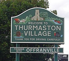
320:
319:
316:
310:
309:
308:United Kingdom
306:
300:
299:
292:
286:
285:
283:
282:
276:
274:
268:
267:
265:
264:
262:Leicestershire
258:
256:
250:
249:
247:
246:
240:
238:
232:
231:
229:
228:
224:
222:
216:
215:
206:
200:
199:
196:
192:
191:
185:Leicestershire
182:
176:
175:
168:
167:
161:
160:
159:
158:
155:
154:
146:
145:
137:
134:
133:
48:
46:
39:
15:
13:
10:
9:
6:
4:
3:
2:
1391:
1380:
1377:
1375:
1372:
1370:
1367:
1366:
1364:
1349:
1346:
1344:
1341:
1339:
1338:Barkby Thorpe
1336:
1335:
1333:
1329:
1323:
1320:
1318:
1315:
1313:
1310:
1308:
1305:
1303:
1300:
1298:
1295:
1293:
1290:
1288:
1285:
1283:
1280:
1278:
1277:South Croxton
1275:
1273:
1270:
1268:
1265:
1263:
1260:
1258:
1255:
1253:
1250:
1248:
1245:
1243:
1240:
1238:
1235:
1233:
1230:
1228:
1225:
1223:
1220:
1218:
1215:
1213:
1210:
1209:
1207:
1203:
1197:
1194:
1192:
1189:
1187:
1184:
1182:
1179:
1177:
1174:
1172:
1169:
1167:
1164:
1162:
1159:
1157:
1154:
1153:
1151:
1147:
1142:
1132:
1129:
1127:
1124:
1122:
1121:
1117:
1116:
1114:
1110:
1106:
1098:
1093:
1091:
1086:
1084:
1079:
1078:
1075:
1069:
1066:
1064:
1061:
1059:
1056:
1055:
1051:
1035:
1028:
1022:
1019:
1003:
997:
994:
989:
983:
980:
975:
969:
966:
953:
947:
944:
937:
925:
922:
920:
917:
915:
912:
911:
908:
901:
899:
898:
895:
894:Barkby Thorpe
892:
884:
875:
873:
870:
869:
866:
859:
857:
856:
853:
850:
848:
845:
843:
840:
839:
834:
825:
820:
818:
813:
811:
806:
805:
802:
795:
791:
787:
783:
778:
773:
772:
768:
766:
764:
760:
756:
752:
748:
740:
738:
732:
730:
728:
723:
721:
720:
715:
714:
709:
704:
701:
699:
694:
692:
688:
685:
676:
669:
667:
665:
661:
657:
649:
646:
643:
642:
641:
639:
635:
632:
624:
622:
620:
615:
613:
609:
605:
601:
596:
594:
590:
582:
578:
576:
571:
569:
565:
561:
557:
553:
549:
544:
542:
537:
535:
531:
530:Barkby Thorpe
527:
523:
519:
515:
506:
499:
497:
495:
491:
486:
484:
480:
476:
472:
468:
458:
427:
424:
422:
419:
417:
414:
409:
408:
405:
399:
396:
395:
393:
391:
383:
380:
379:East Midlands
377:
375:
368:
365:
363:
356:
353:
351:
339:
337:
330:
327:
325:
317:
315:
307:
305:
297:
293:
291:
281:
280:East Midlands
278:
277:
275:
273:
263:
260:
259:
257:
255:
245:
242:
241:
239:
237:
226:
225:
223:
221:
217:
212:
207:
205:
197:
193:
186:
165:
156:
152:
142:
130:
127:
119:
108:
105:
101:
98:
94:
91:
87:
84:
80:
77: –
76:
72:
71:Find sources:
65:
61:
55:
54:
49:This article
47:
43:
38:
37:
34:
30:
26:
22:
1287:Thrussington
1257:Queniborough
1237:Hamilton Lea
1195:
1171:East Goscote
1120:Loughborough
1118:
1037:. Retrieved
1033:
1021:
1009:. Retrieved
996:
982:
968:
956:. Retrieved
946:
882:
763:East Goscote
744:
736:
726:
724:
717:
711:
707:
705:
702:
695:
681:
653:
628:
616:
597:
587:
572:
545:
538:
511:
487:
471:civil parish
466:
465:
220:Civil parish
122:
113:
103:
96:
89:
82:
75:"Thurmaston"
70:
58:Please help
53:verification
50:
33:
1297:Ulverscroft
1176:Mountsorrel
924:Rushey Mead
919:Rushey Mead
914:Rushey Mead
782:Offranville
656:Key Stage 3
612:Dion Dublin
589:Taylorcraft
534:Rushey Mead
483:2011 census
452: /
198:9,668
116:August 2009
1363:Categories
1292:Thurcaston
1227:Cossington
1196:Thurmaston
938:References
883:Thurmaston
769:Twin towns
687:superstore
670:Facilities
631:Key Stages
602:team, the
598:The local
562:, and two
560:River Soar
467:Thurmaston
437:52°40′31″N
227:Thurmaston
195:Population
177:Thurmaston
144:Thurmaston
86:newspapers
29:Thurvaston
25:Thurlaston
21:Thurcaston
1348:Prestwold
1322:Wymeswold
1312:Woodhouse
1282:Swithland
755:Centrebus
733:Landmarks
625:Education
552:Fosse Way
490:Leicester
481:. At the
440:1°05′57″W
398:Charnwood
374:Ambulance
318:LEICESTER
314:Post town
244:Charnwood
1272:Seagrave
1232:Cropston
1166:Birstall
1126:Shepshed
1039:23 March
872:Birstall
842:Birstall
600:football
518:Birstall
236:District
211:SK608090
1331:Hamlets
1267:Rearsby
1242:Hathern
1186:Rothley
1011:13 June
564:marinas
421:England
296:England
290:Country
100:scholar
1307:Wanlip
1212:Barkby
1191:Sileby
1156:Anstey
1131:Syston
958:13 May
852:Syston
847:Syston
790:France
759:Syston
664:Syston
593:Auster
556:Romans
526:Barkby
522:Syston
350:Police
272:Region
102:
95:
88:
81:
73:
1343:Cotes
1247:Hoton
1217:Beeby
1181:Quorn
1112:Towns
1030:(PDF)
1005:(PDF)
107:JSTOR
93:books
27:, or
1041:2019
1013:2018
960:2013
753:and
684:Asda
636:and
573:The
528:and
494:A563
362:Fire
340:0116
79:news
473:in
329:LE4
62:by
1365::
1032:.
788:,
784:,
749:,
666:.
416:UK
23:,
1096:e
1089:t
1082:v
1043:.
1015:.
962:.
823:e
816:t
809:v
638:2
634:1
129:)
123:(
118:)
114:(
104:·
97:·
90:·
83:·
56:.
31:.
Text is available under the Creative Commons Attribution-ShareAlike License. Additional terms may apply.