20:
72:
80:
Simmental race. A spectacular event is the alpine procession in June, when 350 cattle move up the steepest cow track in
Switzerland through the rock wall. From the milk of the cows, the Alpine dairymen using old handicraft techniques produce a Bernese Alp cheese which is so searched for that it is sold in private and not available in open market. (Ernst Roth,
79:
Since the Middle Ages, the
Engstligenalp has been used as alpine pasture. Today it is owned by an alp cooperative of about 100 farmers from Frutigen and Adelboden. It offers from end of June to mid September pasture for 500 cattle (about one third cows, and one third calves) of the big brown-white
55:
which cascade in one of the most impressive waterfalls of the western Swiss alps 600 metres (2,000 ft) down to the
Engstligen Valley. Access from the north is via a mule track blasted into the 600 metres (2,000 ft) high rock beside the waterfalls. Since the 1920s, there has also been a
50:
The 7 square kilometres (2.7 sq mi) plateau, which belongs to the community of
Adelboden, has the form of an oval measuring in a north-south direction 1 kilometre (0.62 mi) an in an east-west direction 2 kilometres (1.2 mi) and is surrounded by mountains, dominated by the
51:
Wildstrubel in the southwest. It is covered by alpine pastures and crossed by numerous mountain streams springing from the slopes. At the exit of the valley, the streams join to form the
44:
149:
SR 451.11 Anhang
Landschaften und Naturdenkmäler von nationaler Bedeutung (Verordnung über das Bundesinventar der Landschaften und Naturdenkmäler
280:
118:
routes and winter hiking routes usable from
December to April on the plateau and a winter hiking path also usable for Nordic alpin hiking
265:
324:
242:
319:
203:
43:
at 1,900–2,000 metres (6,200–6,600 ft) above sea level. Since 1996, it has belonged to the Swiss culture
56:
cable car. A hiking trail leads south over three mountain passes (Chindbettipass, Rote Chumme, Gemmi) to
254:
115:
329:
174:
19:
107:
route of 5 km including the necessary infrastructure in the two guest houses, offering to
52:
269:
246:
122:
119:
313:
262:
188:
71:
129:
148:
121:
as well as several skilifts at the northern slope offering easy and difficult
108:
104:
36:
295:
282:
126:
57:
40:
239:
100:
162:
92:
32:
207:
96:
61:
70:
65:
231:
91:
111:
people the chance to enjoy an unspoilt alpine landscape.
263:Documentary: Alpine procession to Engstligenalp
189:Rundwanderweg (Kinderwagen und Rollstuhlgängig)
8:
95:with two guest houses. In summer, it offers
255:Engstligenalp, official data on alp economy
165:Engstligenalp in the upper left quadrant
18:
141:
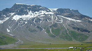
23:Engstligenalp and Wildstrubel mountain
7:
14:
175:Fotogalerie - Hickory-Wedeln 2007
45:landscapes of national importance
16:Plateau of the western Swiss Alps
125:passages and a special area for
103:routes and, as a specialty, a
1:
64:, another leads west to the
346:
204:"Intermaps.com/abelboden"
114:In winter, there are two
76:
24:
74:
22:
296:46.44917°N 7.56500°E
116:cross-country skiing
82:z'Bärg im Frutigland
292: /
39:. It lies south of
325:Plateaus of Europe
268:2009-09-07 at the
245:2017-01-11 at the
84:, volume three of
77:
25:
301:46.44917; 7.56500
240:Adelboden tourism
337:
320:Bernese Oberland
307:
306:
304:
303:
302:
297:
293:
290:
289:
288:
285:
274:
259:
251:
236:
232:engstligenalp.ch
219:
218:
216:
215:
206:. Archived from
200:
194:
193:
186:
180:
179:
172:
166:
160:
154:
153:
146:
86:Wege zum Alpkäse
53:Engstligen Falls
345:
344:
340:
339:
338:
336:
335:
334:
310:
309:
300:
298:
294:
291:
286:
283:
281:
279:
278:
272:
270:Wayback Machine
257:
249:
247:Wayback Machine
234:
228:
223:
222:
213:
211:
202:
201:
197:
191:
187:
183:
177:
173:
169:
161:
157:
151:
147:
143:
138:
35:of the western
17:
12:
11:
5:
343:
341:
333:
332:
327:
322:
312:
311:
276:
275:
260:
252:
237:
227:
226:External links
224:
221:
220:
195:
181:
167:
155:
140:
139:
137:
134:
15:
13:
10:
9:
6:
4:
3:
2:
342:
331:
328:
326:
323:
321:
318:
317:
315:
308:
305:
271:
267:
264:
261:
256:
253:
248:
244:
241:
238:
233:
230:
229:
225:
210:on 2006-01-17
209:
205:
199:
196:
190:
185:
182:
176:
171:
168:
164:
159:
156:
150:
145:
142:
135:
133:
131:
128:
124:
120:
117:
112:
110:
106:
102:
98:
94:
89:
87:
83:
75:Engstligenalp
73:
69:
67:
63:
59:
54:
48:
46:
42:
38:
34:
30:
29:Engstligenalp
21:
277:
250:(in English)
212:. Retrieved
208:the original
198:
184:
170:
163:Panorama map
158:
144:
130:snowboarding
113:
90:
85:
81:
78:
49:
28:
26:
299: /
273:(in German)
258:(in German)
235:(in German)
192:(in German)
178:(in German)
152:(in German)
109:handicapped
314:Categories
284:46°26′57″N
214:2006-02-11
136:References
105:wheelchair
37:Swiss Alps
330:Adelboden
287:7°33′54″E
127:off-piste
58:Leukerbad
41:Adelboden
266:Archived
243:Archived
123:downhill
101:climbing
68:valley.
93:tourism
60:in the
33:plateau
62:Valais
97:hikes
31:is a
99:and
66:Lenk
27:The
316::
132:.
88:)
47:.
217:.
Text is available under the Creative Commons Attribution-ShareAlike License. Additional terms may apply.
