| Name
|
Location
|
Date Listed
|
Grid Ref.
|
Geo-coordinates
|
Notes
|
LB Number
|
Image
|
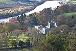
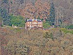
| Canal Street and Tay Street, Greyfriars Burial Ground including Gates and Boundary Walls
|
Perth
|
|
NO1199623263
|
56°23′37″N 3°25′38″W / 56.39367°N 3.42718°W / 56.39367; -3.42718 (Canal Street and Tay Street, Greyfriars Burial Ground including Gates and Boundary Walls)
|
|
39338
|
 Upload another image
|
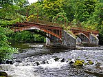
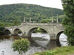
| Bridge of Ruim
|
Over Quiech Burn east of Alyth
|
|
NO2695349304
|
56°37′47″N 3°11′32″W / 56.629857°N 3.192274°W / 56.629857; -3.192274 (Bridge of Ruim)
|
Early-18th-century packhorse bridge
|
53
|

Upload Photo
|
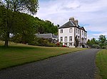
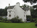
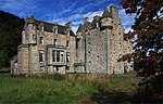
| Old Fincastle House
|
Glen Fincastle, south of Blair Atholl
|
|
NN8678462175
|
56°44′15″N 3°51′09″W / 56.737433°N 3.852377°W / 56.737433; -3.852377 (Old Fincastle House)
|
17th-century house
|
69
|
Upload Photo
|
| Stobhall, Sundial No. 2
|
North-east of Stanley
|
|
NO1325234477
|
56°29′40″N 3°24′38″W / 56.494354°N 3.410564°W / 56.494354; -3.410564 (Stobhall, Sundial No. 2)
|
17th-century faceted sundial
|
79
|
Upload Photo
|
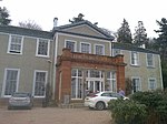
| Drummonie House
|
South-west of Bridge of Earn
|
|
NO1171117088
|
56°20′16″N 3°25′47″W / 56.337892°N 3.429713°W / 56.337892; -3.429713 (Drummonie House)
|
Late-17th- or early-18th-century house
|
163
|
 Upload another image
|
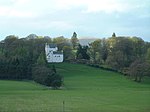
| Balhary House
|
South of Alyth
|
|
NO2643446602
|
56°36′20″N 3°12′00″W / 56.605507°N 3.199961°W / 56.605507; -3.199961 (Balhary House)
|
Late Georgian country house
|
4379
|
Upload Photo
|
| Bridge of Isla
|
Over River Isla near Meikleour
|
|
NO1637238142
|
56°31′40″N 3°21′40″W / 56.527836°N 3.361085°W / 56.527836; -3.361085 (Bridge of Isla)
|
Late-18th-century five-arch bridge
|
4424
|
 Upload another image
|
| Gourdie House
|
Craigie
|
|
NO1225642314
|
56°33′52″N 3°25′46″W / 56.564555°N 3.429384°W / 56.564555; -3.429384 (Gourdie House)
|
18th-century house
|
4440
|
 Upload another image
See more images
|
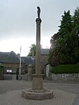
| Meikleour Mercat Cross
|
Meikleour
|
|
NO1575039530
|
56°32′25″N 3°22′18″W / 56.540191°N 3.371644°W / 56.540191; -3.371644 (Meikleour Mercat Cross)
|
mercat cross dated 1698
|
4446
|
 Upload another image
|
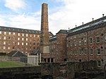
| Stanley Mills, Bell Mill (or West Mill)
|
Stanley
|
|
NO1134532833
|
56°28′45″N 3°26′27″W / 56.479234°N 3.440967°W / 56.479234; -3.440967 (Stanley Mills, Bell Mill (or West Mill))
|
Cotton mill of 1787, brick with iron columns, "perhaps the finest and best-preserved cotton mill with which Sir Richard Arkwright was concerned"
|
4486
|
 Upload another image
See more images
|
| Stanley Mills, Mid Mill
|
Stanley
|
|
NO1137432809
|
56°28′44″N 3°26′26″W / 56.479024°N 3.440488°W / 56.479024; -3.440488 (Stanley Mills, Mid Mill)
|
Cotton mill of c. 1823, contains "probably the oldest cotton-spinning machinery in Scotland"
|
4489
|
Upload another image
|
| Kilgraston House
|
Bridge of Earn
|
|
NO1254717502
|
56°20′30″N 3°24′59″W / 56.341766°N 3.416333°W / 56.341766; -3.416333 (Kilgraston House)
|
Georgian house of c. 1793
|
4527
|
 Upload another image
See more images
|
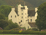
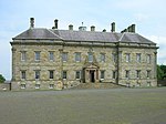
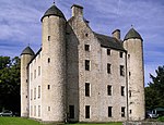
| Aberuchill Castle
|
Strathearn, west of Comrie
|
|
NN7449221162
|
56°21′58″N 4°02′00″W / 56.366065°N 4.03333°W / 56.366065; -4.03333 (Aberuchill Castle)
|
17th-century tower house with later additions
|
5296
|
 Upload another image
See more images
|
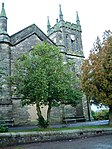
| Comrie Old Parish Church
|
Comrie
|
|
NN7728621954
|
56°22′26″N 3°59′19″W / 56.37391°N 3.988502°W / 56.37391; -3.988502 (Comrie Old Parish Church)
|
Gothic church of 1805
|
5385
|
 Upload another image
|
| 1 Dunira Street
|
Comrie
|
|
NN7731221995
|
56°22′27″N 3°59′17″W / 56.374284°N 3.988101°W / 56.374284; -3.988101 (1 Dunira Street)
|
Shop and offices, 1904 by Charles Rennie Mackintosh
|
5393
|
 Upload another image
See more images
|
| Balmanno Castle
|
Aberargie
|
|
NO1435715575
|
56°19′29″N 3°23′11″W / 56.32479°N 3.386434°W / 56.32479; -3.386434 (Balmanno Castle)
|
16th-century tower house
|
5422
|
 Upload another image
See more images
|
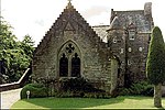
| Ecclesiamagirdle House
|
South-west of Bridge of Earn
|
|
NO1075616398
|
56°19′53″N 3°26′42″W / 56.331516°N 3.444921°W / 56.331516; -3.444921 (Ecclesiamagirdle House)
|
17th-century T-plan house
|
5427
|
Upload Photo
|
| Ecclesiamagirdle House: Dovecot
|
South-west of Bridge of Earn
|
|
NO1077416398
|
56°19′53″N 3°26′41″W / 56.33152°N 3.44463°W / 56.33152; -3.44463 (Ecclesiamagirdle House: Dovecot)
|
17th-century circular dovecote
|
5430
|
Upload Photo
|
| Balvaird Castle
|
Ochil Hills, east of Glenfarg
|
|
NO1698211536
|
56°17′20″N 3°20′34″W / 56.28898°N 3.342728°W / 56.28898; -3.342728 (Balvaird Castle)
|
Late-15th-century tower house
|
5466
|
 Upload another image
See more images
|
| Stobhall Chapel Block
|
North-east of Stanley
|
|
NO1319734351
|
56°29′36″N 3°24′41″W / 56.493213°N 3.411415°W / 56.493213; -3.411415 (Stobhall Chapel Block)
|
16th-century chapel and tower house
|
5473
|
 Upload another image
|
| Stobhall Laundry, Brewhouse and Bakehouse
|
North-east of Stanley
|
|
NO1319234364
|
56°29′36″N 3°24′41″W / 56.493328°N 3.411501°W / 56.493328; -3.411501 (Stobhall Laundry, Brewhouse and Bakehouse)
|
16th- 17th-century vernacular buildings
|
5474
|
Upload Photo
|
| Stobhall Dowery House
|
North-east of Stanley
|
|
NO1320834371
|
56°29′36″N 3°24′40″W / 56.493394°N 3.411243°W / 56.493394; -3.411243 (Stobhall Dowery House)
|
17th-century house
|
5475
|
Upload another image
|
| Stobhall New Library
|
North-east of Stanley
|
|
NO1318734339
|
56°29′35″N 3°24′42″W / 56.493103°N 3.411573°W / 56.493103; -3.411573 (Stobhall New Library)
|
1965 replica of earlier building
|
5477
|
Upload Photo
|
| Stobhall, Sundial No. 1
|
North-east of Stanley
|
|
NO1321234399
|
56°29′37″N 3°24′40″W / 56.493646°N 3.411187°W / 56.493646; -3.411187 (Stobhall, Sundial No. 1)
|
Possibly 17th-century
|
5479
|
Upload Photo
|
| Dunkeld Bridge
|
Over River Tay at Dunkeld
|
|
NO0267542453
|
56°33′50″N 3°35′07″W / 56.563913°N 3.585275°W / 56.563913; -3.585275 (Dunkeld Bridge)
|
Seven-arch bridge of 1809, by Thomas Telford
|
5620
|
 Upload another image
See more images
|
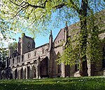
| Dunkeld Cathedral
|
Dunkeld
|
|
NO0239342595
|
56°33′54″N 3°35′24″W / 56.56513°N 3.589916°W / 56.56513; -3.589916 (Dunkeld Cathedral)
|
Oldest parts are 13th-century, with additions of the 14th, 15th, 17 and 19th centuries
|
5631
|
 Upload another image
See more images
|
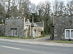
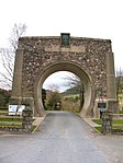
| Blackcraig Bridge
|
Over River Ardle on Blackcraig Castle drive
|
|
NO1083453607
|
56°39′57″N 3°27′23″W / 56.665707°N 3.456415°W / 56.665707; -3.456415 (Blackcraig Bridge)
|
19th-century bridge with picturesque gatehouses
|
5674
|
 Upload another image
|
| Ardblair Castle
|
Blairgowrie
|
|
NO1635844530
|
56°35′07″N 3°21′48″W / 56.585206°N 3.363374°W / 56.585206; -3.363374 (Ardblair Castle)
|
17th- 18th-century tower house and courtyard
|
5677
|
 Upload another image
See more images
|
| Cleish Castle
|
Cleish Hills, south of Kinross
|
|
NT0824097974
|
56°09′56″N 3°28′45″W / 56.165563°N 3.4792°W / 56.165563; -3.4792 (Cleish Castle)
|
16th-century tower house
|
5711
|
 Upload another image
See more images
|
| Blair Adam
|
Kelty
|
|
NT1292995700
|
56°08′46″N 3°24′11″W / 56.146019°N 3.402974°W / 56.146019; -3.402974 (Blair Adam)
|
House of 1733 by William Adam
|
5715
|
Upload Photo
|
| Tummel Bridge
|
Over River Tummel west of Loch Tummel
|
|
NN7624559180
|
56°42′28″N 4°01′23″W / 56.707866°N 4.023099°W / 56.707866; -4.023099 (Tummel Bridge)
|
Single-arch bridge by George Wade, c. 1734
|
5742
|
 Upload another image
See more images
|
| Monzie Castle
|
Crieff
|
|
NN8737924502
|
56°23′57″N 3°49′35″W / 56.399302°N 3.826276°W / 56.399302; -3.826276 (Monzie Castle)
|
17th-century tower house with 18th-century range
|
5779
|
 Upload another image
See more images
|
| Innerpeffray Library
|
Innerpeffray, by Crieff
|
|
NN9018418347
|
56°20′41″N 3°46′42″W / 56.344692°N 3.778278°W / 56.344692; -3.778278 (Innerpeffray Library)
|
Purpose-built library completed 1762
|
5792
|
 Upload another image
See more images
|
| Montrose Mausoleum
|
Aberuthven, St Kattan's Churchyard
|
|
NN9735015103
|
56°19′02″N 3°39′40″W / 56.317169°N 3.661132°W / 56.317169; -3.661132 (Montrose Mausoleum)
|
Mausoleum of the Dukes of Montrose, designed by John Adam in 1736
|
5819
|
 Upload another image
See more images
|
| Clunie Castle
|
Loch of Clunie, Clunie
|
|
NO1132044015
|
56°34′47″N 3°26′43″W / 56.579655°N 3.445192°W / 56.579655; -3.445192 (Clunie Castle)
|
Ruined 16th-century tower house
|
5843
|
 Upload another image
See more images
|
| Keltie Castle
|
Dunning
|
|
NO0075813274
|
56°18′05″N 3°36′19″W / 56.30147°N 3.60537°W / 56.30147; -3.60537 (Keltie Castle)
|
17th-century tower house with later alterations
|
5912
|
Upload Photo
|
| Duncrub House: Dovecot
|
Dunning
|
|
NO0148714967
|
56°19′01″N 3°35′39″W / 56.316826°N 3.594228°W / 56.316826; -3.594228 (Duncrub House: Dovecot)
|
18th-century dovecote
|
5915
|
 Upload another image
|
| Parish Church of St. Serf
|
Dunning
|
|
NO0190514490
|
56°18′45″N 3°35′14″W / 56.312629°N 3.587295°W / 56.312629; -3.587295 (Parish Church of St. Serf)
|
Medieval church
|
52454
|
 Upload another image
See more images
|
| Auchleeks House
|
Trinafour
|
|
NN7412664634
|
56°45′23″N 4°03′37″W / 56.756264°N 4.060365°W / 56.756264; -4.060365 (Auchleeks House)
|
Late Georgian house
|
6054
|
Upload Photo
|
| Blair Castle, Front Lodge
|
Blair Atholl
|
|
NN8727665451
|
56°46′01″N 3°50′45″W / 56.766967°N 3.845782°W / 56.766967; -3.845782 (Blair Castle, Front Lodge)
|
1869 lodge by David Bryce
|
6064
|
 Upload another image
|
| Blair Castle, River Tilt Grotto
|
On River Tilt, Blair Atholl
|
|
NN8756566305
|
56°46′29″N 3°50′29″W / 56.774705°N 3.841432°W / 56.774705; -3.841432 (Blair Castle, River Tilt Grotto)
|
18th-century Gothic viewpoint at York Cascade
|
6065
|
Upload Photo
|
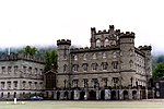
| Blair Castle
|
Blair Atholl
|
|
NN8657766186
|
56°46′24″N 3°51′27″W / 56.773397°N 3.857537°W / 56.773397; -3.857537 (Blair Castle)
|
15th-century tower house with 16th- and 17th-century additions, remodelled by David Bryce in the 19th century
|
6074
|
 Upload another image
See more images
|
| Blair Castle, Walled Garden, Sundial
|
Blair Atholl
|
|
NN8648866182
|
56°46′24″N 3°51′32″W / 56.773339°N 3.85899°W / 56.773339; -3.85899 (Blair Castle, Walled Garden, Sundial)
|
Brass sundial of 1743
|
6076
|
 Upload another image
|
| Keithick House
|
Burrelton
|
|
NO2031438539
|
56°31′56″N 3°17′50″W / 56.532087°N 3.297144°W / 56.532087; -3.297144 (Keithick House)
|
Early-19th-century Neoclassical house
|
6170
|
Upload Photo
|
| Stanley Mills, East Mill
|
Stanley
|
|
NO1142432825
|
56°28′45″N 3°26′23″W / 56.479177°N 3.439682°W / 56.479177; -3.439682 (Stanley Mills, East Mill)
|
19th-century cotton mill
|
6690
|
 Upload another image
See more images
|
| Megginch Castle
|
Errol
|
|
NO2419524605
|
56°24′27″N 3°13′48″W / 56.407576°N 3.230009°W / 56.407576; -3.230009 (Megginch Castle)
|
15th-century tower house with later additions, including a wing by Robert Adam
|
10963
|
 Upload another image
See more images
|
| Megginch Castle, Stables
|
Errol
|
|
NO2414224670
|
56°24′29″N 3°13′51″W / 56.408151°N 3.230886°W / 56.408151; -3.230886 (Megginch Castle, Stables)
|
Early-19th-century Gothic stable courtyard
|
10964
|
Upload Photo
|
| Megginch Castle, North Lodges
|
Errol
|
|
NO2348124936
|
56°24′38″N 3°14′30″W / 56.410434°N 3.241673°W / 56.410434; -3.241673 (Megginch Castle, North Lodges)
|
Late-18th-century gatehouse lodges
|
10969
|
 Upload another image
|
| Balthayock House, Bridge over Hail Pool
|
North-west of Glencarse
|
|
NO1779223096
|
56°23′35″N 3°20′00″W / 56.39295°N 3.333264°W / 56.39295; -3.333264 (Balthayock House, Bridge over Hail Pool)
|
Cast-iron bridge c. 1870, on north-east drive of Balthayock House
|
10986
|
Upload Photo
|
| Forteviot Square
|
Forteviot
|
|
NO0514817523
|
56°20′26″N 3°32′10″W / 56.340529°N 3.535988°W / 56.340529; -3.535988 (Forteviot Square)
|
U-plan group of single-storey houses by James Miller, 1925
|
11057
|
 Upload another image
|
| Forteviot Hall
|
Forteviot
|
|
NO0518317488
|
56°20′25″N 3°32′07″W / 56.340222°N 3.535409°W / 56.340222; -3.535409 (Forteviot Hall)
|
Village hall by James Miller, 1925
|
11058
|
 Upload another image
|
| Invermay House
|
South of Forteviot
|
|
NO0606816095
|
56°19′40″N 3°31′14″W / 56.327888°N 3.520601°W / 56.327888; -3.520601 (Invermay House)
|
Mid 18th-century Georgian house
|
11071
|
Upload Photo
|
| Old House of Invermay
|
South of Forteviot
|
|
NO0608716206
|
56°19′44″N 3°31′13″W / 56.328888°N 3.520334°W / 56.328888; -3.520334 (Old House of Invermay)
|
Late-16th-century tower house
|
11074
|
Upload Photo
|
| Hermitage Bridge
|
Over River Braan at The Hermitage, Dunkeld
|
|
NO0087541753
|
56°33′26″N 3°36′51″W / 56.55725°N 3.614284°W / 56.55725; -3.614284 (Hermitage Bridge)
|
Rustic stone arch bridge, c. 1785
|
11104
|
 Upload another image
See more images
|
| Dalguise Viaduct
|
Over River Tay at Dalguise
|
|
NN9949747943
|
56°36′45″N 3°38′21″W / 56.612544°N 3.639097°W / 56.612544; -3.639097 (Dalguise Viaduct)
|
Lattice-girder railway viaduct of 1863, by Joseph Mitchell
|
11117
|
 Upload another image
See more images
|
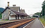
| Dunkeld & Birnam railway station
|
Dunkeld and Birnam
|
|
NO0308441676
|
56°33′25″N 3°34′42″W / 56.55702°N 3.578332°W / 56.55702; -3.578332 (Dunkeld & Birnam railway station)
|
Gothic station building of 1856, by Andrew Heiton Jr.
|
11139
|
 Upload another image
See more images
|
| Murthly Castle, Roman Bridge
|
Over Birnam Burn, Murthly
|
|
NO0570339536
|
56°32′18″N 3°32′06″W / 56.538335°N 3.534963°W / 56.538335; -3.534963 (Murthly Castle, Roman Bridge)
|
Mid 19th-century six-arch bridge in the style of a Roman aqueduct
|
11145
|
Upload Photo
|
| Murthly Castle
|
Murthly
|
|
NO0705039560
|
56°32′20″N 3°30′47″W / 56.538819°N 3.513077°W / 56.538819; -3.513077 (Murthly Castle)
|
16th-century tower house with later additions
|
11146
|
 Upload another image
See more images
|
| Murthly Castle, Walled Garden
|
Murthly
|
|
NO0721439811
|
56°32′28″N 3°30′38″W / 56.541106°N 3.510501°W / 56.541106; -3.510501 (Murthly Castle, Walled Garden)
|
Walled garden dating to the 17th century
|
11147
|
Upload Photo
|
| Kinross House
|
Kinross
|
|
NO1263702044
|
56°12′11″N 3°24′35″W / 56.202946°N 3.40976°W / 56.202946; -3.40976 (Kinross House)
|
Begun in 1686, by Sir William Bruce
|
11200
|
 Upload another image
See more images
|
| Dalreoch Bridge
|
Over River Earn north of Dunning
|
|
NO0038417896
|
56°20′34″N 3°36′47″W / 56.3429°N 3.613161°W / 56.3429; -3.613161 (Dalreoch Bridge)
|
18th-century four-arch bridge
|
11211
|
Upload Photo
|
| Kinnaird Castle
|
Kinnaird, Gowrie
|
|
NO2412228904
|
56°26′46″N 3°13′57″W / 56.446178°N 3.23244°W / 56.446178; -3.23244 (Kinnaird Castle)
|
Tower house of c. 1500
|
11218
|
 Upload another image
See more images
|
| Kirk O' The Muir
|
Murthly
|
|
NO1122137044
|
56°31′01″N 3°26′40″W / 56.51703°N 3.444416°W / 56.51703; -3.444416 (Kirk O' The Muir)
|
Disused United Presbyterian Church
|
11233
|
Upload Photo
|
| Hilton House
|
Bridge of Earn
|
|
NO1163320067
|
56°21′53″N 3°25′55″W / 56.364633°N 3.431977°W / 56.364633; -3.431977 (Hilton House)
|
Little-altered house of 1732
|
11329
|
Upload Photo
|
| Tulliebole Castle
|
Crook of Devon
|
|
NO0526800575
|
56°11′18″N 3°31′41″W / 56.188342°N 3.527967°W / 56.188342; -3.527967 (Tulliebole Castle)
|
16th-century tower house
|
11459
|
 Upload another image
See more images
|
| Aldie Castle
|
Crook of Devon
|
|
NT0500597789
|
56°09′48″N 3°31′52″W / 56.163268°N 3.531207°W / 56.163268; -3.531207 (Aldie Castle)
|
16th-century tower house
|
11469
|
 Upload another image
See more images
|
| Errol Parish Church
|
Errol
|
|
NO2526922959
|
56°23′35″N 3°12′44″W / 56.392963°N 3.212139°W / 56.392963; -3.212139 (Errol Parish Church)
|
18th-century Gothic church by James Gillespie Graham
|
11589
|
 Upload another image
See more images
|
| Errol Park House
|
Errol
|
|
NO2476122611
|
56°23′23″N 3°13′13″W / 56.389756°N 3.220266°W / 56.389756; -3.220266 (Errol Park House)
|
19th-century Renaissance-style house by Alexander Johnston
|
11598
|
 Upload another image
|
| Errol Park Stables
|
Errol
|
|
NO2472722659
|
56°23′25″N 3°13′15″W / 56.390182°N 3.22083°W / 56.390182; -3.22083 (Errol Park Stables)
|
Early-19th-century circular-plan stable courtyard
|
11599
|
 Upload another image
|
| Seasyde House
|
Errol
|
|
NO2836424383
|
56°24′22″N 3°09′45″W / 56.406233°N 3.162406°W / 56.406233; -3.162406 (Seasyde House)
|
Country house of c. 1800
|
11605
|
Upload Photo
|
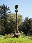
| Fingask Castle sundial
|
Rait
|
|
NO2283327442
|
56°25′58″N 3°15′10″W / 56.432837°N 3.252911°W / 56.432837; -3.252911 (Fingask Castle sundial)
|
Polyhedral Baroque sundial, possibly 17th-century
|
11635
|
Upload Photo
|
| Ballindean House
|
Inchture
|
|
NO2685929929
|
56°27′21″N 3°11′18″W / 56.455817°N 3.188341°W / 56.455817; -3.188341 (Ballindean House)
|
Classical country house of 1832
|
11760
|
 Upload another image
|
| Rossie Church
|
Rossie Priory, Longforgan
|
|
NO2916130807
|
56°27′51″N 3°09′04″W / 56.464056°N 3.151237°W / 56.464056; -3.151237 (Rossie Church)
|
Medieval church, rebuilt in the 19th century
|
11786
|
Upload Photo
|
| Old Rossie Market Cross
|
Rossie Priory, Longforgan
|
|
NO2921130728
|
56°27′48″N 3°09′01″W / 56.463353°N 3.150404°W / 56.463353; -3.150404 (Old Rossie Market Cross)
|
Mercat cross dated 1746
|
11787
|
Upload Photo
|
| Grandtully Castle
|
Grandtully
|
|
NN8911751342
|
56°38′27″N 3°48′35″W / 56.640722°N 3.809587°W / 56.640722; -3.809587 (Grandtully Castle)
|
Late-16th-century Z-plan tower house
|
11830
|
 Upload another image
See more images
|
| Grandtully Chapel
|
Grandtully
|
|
NN8869250638
|
56°38′03″N 3°48′58″W / 56.6343°N 3.816209°W / 56.6343; -3.816209 (Grandtully Chapel)
|
16th-century chapel
|
11831
|
 Upload another image
See more images
|
| Logierait Viaduct
|
Over River Tay at Logierait
|
|
NN9686351816
|
56°38′48″N 3°41′01″W / 56.64675°N 3.683541°W / 56.64675; -3.683541 (Logierait Viaduct)
|
Iron railway viaduct, now used as a road bridge
|
11851
|
 Upload another image
See more images
|
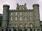
| Kinfauns Castle
|
East of Perth
|
|
NO1504622647
|
56°23′18″N 3°22′39″W / 56.388432°N 3.377586°W / 56.388432; -3.377586 (Kinfauns Castle)
|
Castellated mansion of 1825, by Sir Robert Smirke
|
11955
|
 Upload another image
See more images
|
| Glendoick House
|
St Madoes
|
|
NO2075023605
|
56°23′53″N 3°17′08″W / 56.398028°N 3.285516°W / 56.398028; -3.285516 (Glendoick House)
|
Mid 18th-century Georgian house
|
11966
|
 Upload another image
|
| Taymouth Castle Dairy
|
Kenmore
|
|
NN7797845915
|
56°35′21″N 3°59′19″W / 56.589225°N 3.98853°W / 56.589225; -3.98853 (Taymouth Castle Dairy)
|
Rustic Italianate ornamental building in white quartz
|
12091
|
 Upload another image
See more images
|
| Taymouth Castle
|
Kenmore
|
|
NN7844046523
|
56°35′41″N 3°58′53″W / 56.594804°N 3.981298°W / 56.594804; -3.981298 (Taymouth Castle)
|
Castellated mansion, mainly 19th-century, including work by Archibald Elliot, William Atkinson and James Gillespie Graham
|
12093
|
 Upload another image
See more images
|
| Taymouth Castle, Fort Lodge
|
Kenmore
|
|
NN7902246094
|
56°35′28″N 3°58′18″W / 56.591102°N 3.971625°W / 56.591102; -3.971625 (Taymouth Castle, Fort Lodge)
|
Rustic cottage of late 1830s
|
12096
|
Upload Photo
|
| Taymouth Castle, Chinese Bridge
|
Kenmore
|
|
NN7824346734
|
56°35′48″N 3°59′05″W / 56.596647°N 3.984603°W / 56.596647; -3.984603 (Taymouth Castle, Chinese Bridge)
|
Early-19th-century cast-iron three-arch bridge
|
12097
|
 Upload another image
See more images
|
| Taymouth Castle, Rustic Lodge
|
Kenmore
|
|
NN7893347870
|
56°36′25″N 3°58′26″W / 56.607025°N 3.973905°W / 56.607025; -3.973905 (Taymouth Castle, Rustic Lodge)
|
Rustic cottage of c. 1840
|
12100
|
Upload Photo
|
| Kenmore Bridge
|
Over River Tay at Kenmore
|
|
NN7715045554
|
56°35′09″N 4°00′07″W / 56.585767°N 4.001831°W / 56.585767; -4.001831 (Kenmore Bridge)
|
Seven-arch stone bridge, c. 1774, by John Baxter, possibly working with John Smeaton
|
12138
|
 Upload another image
See more images
|
| Connachan Lodge
|
North of Crieff
|
|
NN8958527582
|
56°25′39″N 3°47′31″W / 56.427481°N 3.791854°W / 56.427481; -3.791854 (Connachan Lodge)
|
Early-19th-century Cottage ornée
|
12213
|
Upload Photo
|
| Abercairny sundial
|
Crieff
|
|
NN9111122393
|
56°22′52″N 3°45′54″W / 56.381239°N 3.764967°W / 56.381239; -3.764967 (Abercairny sundial)
|
17th-century lectern sundial
|
12257
|
Upload Photo
|
| All Souls Episcopal Church
|
Invergowrie Main Street
|
|
NO3460330359
|
56°27′39″N 3°03′46″W / 56.460819°N 3.062825°W / 56.460819; -3.062825 (All Souls Episcopal Church)
|
Late-19th-century Gothic church by Hippolyte Blanc
|
12849
|
 Upload another image
See more images
|
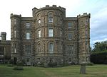
| HMP Castle Huntly
|
Longforgan
|
|
NO3019429105
|
56°26′56″N 3°08′02″W / 56.448922°N 3.134021°W / 56.448922; -3.134021 (HMP Castle Huntly)
|
Mid 15th-century tower house with 18th-century wings, now an open prison
|
12868
|
 Upload another image
See more images
|
| Castle Huntly, North Gates
|
Longforgan
|
|
NO3043629580
|
56°27′12″N 3°07′49″W / 56.453224°N 3.130222°W / 56.453224; -3.130222 (Castle Huntly, North Gates)
|
Late-17th-century Renaissance-style gateway
|
12871
|
 Upload another image
See more images
|
| Longforgan Market Cross
|
Longforgan Main Street
|
|
NO3107630010
|
56°27′26″N 3°07′12″W / 56.457181°N 3.119955°W / 56.457181; -3.119955 (Longforgan Market Cross)
|
Later 17th-century mercat cross
|
13283
|
 Upload another image
See more images
|
| Chapel of St Anthony The Eremite
|
Murthly
|
|
NO0713440061
|
56°32′36″N 3°30′43″W / 56.543335°N 3.511891°W / 56.543335; -3.511891 (Chapel of St Anthony The Eremite)
|
Pre-reformation mortuary chapel, extended by James Gillespie Graham and A W N Pugin in 1846
|
13460
|
 Upload another image
|
| Marlee House (formerly Kinloch House)
|
Kinloch, Blairgowrie
|
|
NO1489544505
|
56°35′05″N 3°23′14″W / 56.584719°N 3.387177°W / 56.584719; -3.387177 (Marlee House (formerly Kinloch House))
|
17th-century house, remodelled c. 1746
|
13742
|
 Upload another image
|
| Inchmartine House
|
Inchture
|
|
NO2624128076
|
56°26′21″N 3°11′52″W / 56.439077°N 3.197841°W / 56.439077; -3.197841 (Inchmartine House)
|
House of c. 1800, incorporating earlier fabric
|
13773
|
 Upload another image
|
| Taymouth Castle, Maxwell's Temple
|
Kenmore
|
|
NN7756145974
|
56°35′23″N 3°59′43″W / 56.589646°N 3.995343°W / 56.589646; -3.995343 (Taymouth Castle, Maxwell's Temple)
|
Monument of 1831 by William Atkinson
|
13804
|
Upload Photo
|
| Meggernie Castle
|
Glenlyon
|
|
NN5538246033
|
56°35′02″N 4°21′22″W / 56.58386°N 4.356209°W / 56.58386; -4.356209 (Meggernie Castle)
|
17th-century tower house
|
13812
|
 Upload another image
See more images
|
| Inchyra House
|
St Madoes
|
|
NO1903621311
|
56°22′38″N 3°18′45″W / 56.377133°N 3.312567°W / 56.377133; -3.312567 (Inchyra House)
|
Classical country house of c. 1800
|
17624
|
 Upload another image
|
| Pitfour Castle
|
St Madoes
|
|
NO1994820880
|
56°22′24″N 3°17′52″W / 56.373417°N 3.297672°W / 56.373417; -3.297672 (Pitfour Castle)
|
Castellated house of 1784 by Robert Adam
|
17628
|
 Upload another image
See more images
|
| Elcho Castle, Dovecot
|
Rhynd
|
|
NO1632720918
|
56°22′23″N 3°21′23″W / 56.373131°N 3.356292°W / 56.373131; -3.356292 (Elcho Castle, Dovecot)
|
Late-16th-century circular dovecote
|
17714
|
 Upload another image
|
| Telephone Call Box
|
Rhynd
|
|
NO1581520055
|
56°21′55″N 3°21′51″W / 56.365289°N 3.364302°W / 56.365289; -3.364302 (Telephone Call Box)
|
"K3" telephone box, the only one surviving in its original location
|
17718
|
 Upload another image
|
| Colquhalzie House
|
East of Muthill
|
|
NN9137317466
|
56°20′13″N 3°45′31″W / 56.337055°N 3.758687°W / 56.337055; -3.758687 (Colquhalzie House)
|
18th-century country house
|
17771
|
Upload Photo
|
| Weem Old Parish Kirk
|
Weem
|
|
NN8429649797
|
56°37′32″N 3°53′15″W / 56.625683°N 3.887455°W / 56.625683; -3.887455 (Weem Old Parish Kirk)
|
17th-century former church, including the funerary monuments of the Menzies family
|
17815
|
 Upload another image
See more images
|
| Williamston House
|
South-west of Methven
|
|
NN9722322056
|
56°22′46″N 3°39′57″W / 56.379582°N 3.665904°W / 56.379582; -3.665904 (Williamston House)
|
Early-17th-century country house
|
17836
|
Upload Photo
|
| Glenalmond College Main Building
|
Glenalmond
|
|
NN9775328984
|
56°26′31″N 3°39′36″W / 56.441913°N 3.660034°W / 56.441913; -3.660034 (Glenalmond College Main Building)
|
Gothic revival college building, begun in 1846 with later additions
|
17869
|
 Upload another image
See more images
|
| Methven Castle
|
Methven
|
|
NO0416626040
|
56°25′01″N 3°33′18″W / 56.416821°N 3.554981°W / 56.416821; -3.554981 (Methven Castle)
|
Country house of 1664 by John Mylne
|
17895
|
 Upload another image
See more images
|
| Dalcrue House
|
Methven
|
|
NO0430327922
|
56°26′02″N 3°33′12″W / 56.43375°N 3.55345°W / 56.43375; -3.55345 (Dalcrue House)
|
Italianate house of 1832 by William Henry Playfair
|
17897
|
Upload Photo
|
| Dry Bridge
|
Methven
|
|
NO0532328346
|
56°26′16″N 3°32′13″W / 56.437764°N 3.53707°W / 56.437764; -3.53707 (Dry Bridge)
|
Part of Lynedoch estate drive, designed by William Henry Playfair in 1832
|
17921
|
 Upload another image
|
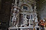
| Methven Aisle, Methven Parish Church
|
Methven
|
|
NO0256826045
|
56°25′00″N 3°34′51″W / 56.416538°N 3.580874°W / 56.416538; -3.580874 (Methven Aisle, Methven Parish Church)
|
15th-century transept of former collegiate church
|
17928
|
Upload Photo
|
| Lochlane House
|
Crieff
|
|
NN8341921358
|
56°22′12″N 3°53′20″W / 56.37011°N 3.888999°W / 56.37011; -3.888999 (Lochlane House)
|
Small mansion of 1710
|
18149
|
Upload Photo
|
| Lawers House
|
Comrie
|
|
NN7992023029
|
56°23′03″N 3°56′47″W / 56.384238°N 3.946375°W / 56.384238; -3.946375 (Lawers House)
|
Country house of 1738 by William Adam
|
18152
|
 Upload another image
|
| Ochtertyre House
|
Ochtertyre
|
|
NN8387523626
|
56°23′26″N 3°52′57″W / 56.390588°N 3.882625°W / 56.390588; -3.882625 (Ochtertyre House)
|
Georgian country house of 1790
|
18170
|
 Upload another image
|
| Belmont Castle
|
Meigle
|
|
NO2861443926
|
56°34′55″N 3°09′49″W / 56.581809°N 3.16372°W / 56.581809; -3.16372 (Belmont Castle)
|
15th-century tower extended in the 18th century, 19th-century alterations
|
18332
|
Upload Photo
|
| Scone Palace
|
Scone
|
|
NO1138726527
|
56°25′21″N 3°26′17″W / 56.422606°N 3.438143°W / 56.422606; -3.438143 (Scone Palace)
|
Early-19th-century rebuilding of earlier house, by William Atkinson
|
18370
|
 Upload another image
See more images
|
| Scone Palace Mortuary Chapel or Mausoleum
|
Scone Palace
|
|
NO1141826636
|
56°25′25″N 3°26′16″W / 56.423591°N 3.437678°W / 56.423591; -3.437678 (Scone Palace Mortuary Chapel or Mausoleum)
|
Remodelling of earlier church aisle by William Atkinson, monument to Viscount Stormont inside
|
18371
|
 Upload another image
|
| Cottown School House
|
Cottown
|
|
NO2057521023
|
56°22′29″N 3°17′15″W / 56.374807°N 3.287567°W / 56.374807; -3.287567 (Cottown School House)
|
18th-century thatched building, formerly a school
|
19809
|
Upload Photo
|
| Haugh of Drimmie Suspension Bridge
|
Over River Ericht at Glenericht Lodge Drive
|
|
NO1700050214
|
56°38′11″N 3°21′17″W / 56.63637°N 3.354752°W / 56.63637; -3.354752 (Haugh of Drimmie Suspension Bridge)
|
Wrought iron bridge built before 1837
|
19830
|
Upload Photo
|
| Old Scone Market Cross
|
Scone Palace
|
|
NO1158026652
|
56°25′26″N 3°26′06″W / 56.423765°N 3.435058°W / 56.423765; -3.435058 (Old Scone Market Cross)
|
Medieval town cross
|
19876
|
 Upload another image
See more images
|
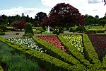
| Drummond Castle Formal Garden
|
Muthill
|
|
NN8444917930
|
56°20′22″N 3°52′15″W / 56.339582°N 3.870825°W / 56.339582; -3.870825 (Drummond Castle Formal Garden)
|
Walled gardens laid out in 1832, with pavilions and 17th-century sundial
|
19883
|
 Upload another image
|
| Aberfeldy Water Mill
|
Aberfeldy
|
|
NN8551949067
|
56°37′10″N 3°52′02″W / 56.619429°N 3.86721°W / 56.619429; -3.86721 (Aberfeldy Water Mill)
|
19th-century water mill, restored in 1988
|
20859
|
 Upload another image
See more images
|
| Tay Bridge
|
Aberfeldy
|
|
NN8513449298
|
56°37′17″N 3°52′25″W / 56.621409°N 3.873583°W / 56.621409; -3.873583 (Tay Bridge)
|
Classically detailed bridge, designed by William Adam and built by General Wade in 1733
|
20861
|
 Upload another image
See more images
|
| Newton Castle
|
Blairgowrie
|
|
NO1716945273
|
56°35′31″N 3°21′01″W / 56.592024°N 3.350413°W / 56.592024; -3.350413 (Newton Castle)
|
Mid 16th-century Z-plan tower house with later additions
|
22314
|
 Upload another image
See more images
|
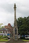
| War Memorial
|
Wellmeadow, Blairgowrie
|
|
NO1799145220
|
56°35′30″N 3°20′13″W / 56.591692°N 3.337015°W / 56.591692; -3.337015 (War Memorial)
|
World War I memorial, designed by Reginald Fairlie and sculpted by Alexander Carrick
|
22321
|
 Upload another image
|
| Keathbank Mill
|
Rattray
|
|
NO1777646153
|
56°36′00″N 3°20′27″W / 56.600034°N 3.340812°W / 56.600034; -3.340812 (Keathbank Mill)
|
19th-century textile mill
|
22332
|
 Upload another image
See more images
|
| Inchglas
|
Crieff
|
|
NN8653021277
|
56°22′13″N 3°50′19″W / 56.37014°N 3.838627°W / 56.37014; -3.838627 (Inchglas)
|
Gothic villa of 1854 by Frederick Thomas Pilkington
|
23488
|
Upload Photo
|
| The Avanti Restaurant (former British Linen Bank)
|
Crieff, 32-34, Crieff High Street
|
|
NN8649021578
|
56°22′22″N 3°50′22″W / 56.372833°N 3.839405°W / 56.372833; -3.839405 (The Avanti Restaurant (former British Linen Bank))
|
Offices of 1900 by George Washington Browne
|
23489
|
 Upload another image
See more images
|
| South United Free Church
|
Crieff
|
|
NN8625721782
|
56°22′29″N 3°50′36″W / 56.374609°N 3.843263°W / 56.374609; -3.843263 (South United Free Church)
|
Later 19th-century Scots Gothic church by J. J. Stevenson
|
23509
|
 Upload another image
|
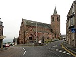
| St John's Kirk
|
Perth
|
|
NO1194223546
|
56°23′45″N 3°25′41″W / 56.395937°N 3.428146°W / 56.395937; -3.428146 (St John's Kirk)
|
15th-century church
|
39300
|
 Upload another image
See more images
|
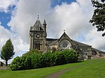
| St Leonard's-in-the-Fields Church
|
Perth
|
|
NO1162723166
|
56°23′33″N 3°25′59″W / 56.392465°N 3.433119°W / 56.392465; -3.433119 (St Leonard's-in-the-Fields Church)
|
Scots Gothic church of 1885 by J. J. Stevenson
|
39310
|
 Upload another image
See more images
|
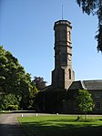
| St Ninian's Cathedral
|
Perth
|
|
NO1147123915
|
56°23′57″N 3°26′09″W / 56.399163°N 3.435898°W / 56.399163; -3.435898 (St Ninian's Cathedral)
|
Mid 19th-century Episcopal cathedral by William Butterfield
|
39314
|
 Upload another image
See more images
|
| King James VI Hospital
|
Perth
|
|
NO1151023427
|
56°23′41″N 3°26′06″W / 56.394788°N 3.435101°W / 56.394788; -3.435101 (King James VI Hospital)
|
Former infirmary and school built 1750, one of the finest 18th-century examples of its type in Scotland
|
39319
|
 Upload another image
See more images
|
| Old Perth Academy
|
Perth
|
|
NO1167824027
|
56°24′01″N 3°25′57″W / 56.400208°N 3.432583°W / 56.400208; -3.432583 (Old Perth Academy)
|
Former school built 1804, by Robert Reid
|
39322
|
 Upload another image
See more images
|
| York Place, A K Bell Library including Boundary Wall to York Place
|
Perth
|
|
NO1135423454
|
56°23′42″N 3°26′15″W / 56.395001°N 3.437637°W / 56.395001; -3.437637 (York Place, A K Bell Library including Boundary Wall to York Place)
|
Neo-classical infirmary by W M Mackenzie, built 1836 and later converted to offices
|
39323
|
 Upload another image
See more images
|
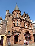
| Perth Sheriff Court
|
Perth
|
|
NO1206223391
|
56°23′40″N 3°25′34″W / 56.394567°N 3.42615°W / 56.394567; -3.42615 (Perth Sheriff Court)
|
Greek Revival court house by Robert Smirke, 1819
|
39325
|
 Upload another image
See more images
|
| Perth Prison, Main Block
|
Perth
|
|
NO1178622395
|
56°23′08″N 3°25′49″W / 56.38557°N 3.430284°W / 56.38557; -3.430284 (Perth Prison, Main Block)
|
Central building of 1812 by Robert Reid, radial buildings added in the 1840s and 1850s by Thomas Brown and Robert Matheson
|
39331
|
 Upload another image
|
| Perth Bridge
|
Over River Tay at Perth
|
|
NO1211823883
|
56°23′56″N 3°25′31″W / 56.398997°N 3.425408°W / 56.398997; -3.425408 (Perth Bridge)
|
Seven-arch bridge by John Smeaton, completed 1771
|
39339
|
 Upload another image
See more images
|
| Perth Water Works
|
Perth
|
|
NO1203823137
|
56°23′32″N 3°25′35″W / 56.392282°N 3.426454°W / 56.392282; -3.426454 (Perth Water Works)
|
Neo-Classical former waterworks, 1832 by Adam Anderson, one of Scotland's most significant industrial buildings, now an art gallery
|
39341
|
 Upload another image
See more images
|
| Pitheavlis Castle
|
Perth
|
|
NO1051822805
|
56°23′20″N 3°27′03″W / 56.389014°N 3.450953°W / 56.389014; -3.450953 (Pitheavlis Castle)
|
Late-16th-century L-plan tower house
|
39346
|
 Upload another image
See more images
|
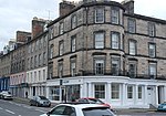
| 2–8 Atholl Crescent
|
Perth
|
|
NO1175323910
|
56°23′57″N 3°25′53″W / 56.399171°N 3.431329°W / 56.399171; -3.431329 (2–8 Atholl Crescent)
|
Crescent of houses, begun in 1797
|
39354
|
 Upload another image
|
| 2–4 Charlotte Place and 20 Charlotte Street
|
Perth
|
|
NO1190723846
|
56°23′55″N 3°25′44″W / 56.398625°N 3.428813°W / 56.398625; -3.428813 (2–4 Charlotte Place and 20 Charlotte Street)
|
Neo-Greek houses of circa 1830
|
39392
|
 Upload another image
|
| Barnhill Tollhouse
|
Perth, Dundee Road
|
|
NO1247022754
|
56°23′20″N 3°25′10″W / 56.388922°N 3.41933°W / 56.388922; -3.41933 (Barnhill Tollhouse)
|
Early-19th-century toll house
|
39422
|
 Upload another image
See more images
|
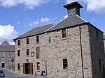
| Upper City Mills (now City Mills Hotel)
|
Perth
|
|
NO1141723731
|
56°23′51″N 3°26′12″W / 56.3975°N 3.43671°W / 56.3975; -3.43671 (Upper City Mills (now City Mills Hotel))
|
18th-century water mill
|
39577
|
Upload Photo
|
| Lower City Mills
|
Perth
|
|
NO1148523722
|
56°23′51″N 3°26′08″W / 56.397432°N 3.435606°W / 56.397432; -3.435606 (Lower City Mills)
|
Early-19th-century water mill
|
39578
|
 Upload another image
See more images
|
| Bank of Scotland
|
St John Street, Perth
|
|
NO1200223519
|
56°23′45″N 3°25′38″W / 56.395706°N 3.427165°W / 56.395706; -3.427165 (Bank of Scotland)
|
Italian Renaissance bank offices of 1846 by David Rhind
|
39618
|
 Upload another image
See more images
|
| Pitlochry Parish Church
|
Pitlochry
|
|
NN9400558286
|
56°42′15″N 3°43′58″W / 56.704209°N 3.73279°W / 56.704209; -3.73279 (Pitlochry Parish Church)
|
Romanesque church of 1884 by Charles & Leslie Ower
|
39850
|
 Upload another image
See more images
|
| Sunnybrae Cottage
|
Pitlochry
|
|
NN9364658315
|
56°42′16″N 3°44′19″W / 56.704388°N 3.738663°W / 56.704388; -3.738663 (Sunnybrae Cottage)
|
Cruck-framed vernacular cottage of late 18th or early 19th century
|
39866
|
 Upload another image
See more images
|
| Pitlochry railway station
|
Pitlochry
|
|
NN9382458103
|
56°42′09″N 3°44′08″W / 56.702525°N 3.735669°W / 56.702525; -3.735669 (Pitlochry railway station)
|
Station buildings built 1890
|
39867
|
 Upload another image
See more images
|
| Castle Menzies
|
Weem
|
|
NN8370149613
|
56°37′26″N 3°53′49″W / 56.623883°N 3.897064°W / 56.623883; -3.897064 (Castle Menzies)
|
16th-century Z-plan tower house
|
43568
|
 Upload another image
See more images
|
| Stobhall, Folly
|
North-east of Stanley
|
|
NO1324734511
|
56°29′41″N 3°24′38″W / 56.494659°N 3.410657°W / 56.494659; -3.410657 (Stobhall, Folly)
|
Summer house built in 1989 to incorporate earlier 18th-century panelling
|
43856
|
Upload Photo
|
| Pitlochry Power Station, dam and fish ladder
|
Loch Faskally, Pitlochry
|
|
NN9354257719
|
56°41′56″N 3°44′24″W / 56.699013°N 3.740113°W / 56.699013; -3.740113 (Pitlochry Power Station, dam and fish ladder)
|
Mid 20th-century hydro-electric power station
|
47534
|
 Upload another image
See more images
|
| Clunie Power Station
|
Loch Faskally
|
|
NN9126759775
|
56°43′01″N 3°46′41″W / 56.71695°N 3.778116°W / 56.71695; -3.778116 (Clunie Power Station)
|
Mid 20th-century hydro-electric power station
|
47621
|
 Upload another image
|
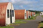
| Cultybraggan Former Cadet Camp, Huts 19 and 20 (Guard's Block) and 44, 45, 46
|
Comrie
|
|
NN7687719948
|
56°21′21″N 3°59′39″W / 56.355792°N 3.994179°W / 56.355792; -3.994179 (Cultybraggan Former Cadet Camp, Huts 19 and 20 (Guard's Block) and 44, 45, 46)
|
Purpose-built World War II Prisoner of War camp, one of the best-preserved in Britain
|
50471
|
 Upload another image
|