86:
Depending on location, the fault has an estimated slip rate between 1.3–9 millimeters (0.051–0.354 in). The recurrence rate between events is uncertain, but if the fault is associated with the 1812 event, it may be able to produce earthquakes approaching 6.5 – 7.3 in magnitude.
100:"Paleoseismologic Evidence for a Very Large (Mw >7), Post-A.D. 1660 Surface Rupture on the Eastern San Cayetano Fault, Ventura County, California: Was This the Elusive Source of the Damaging 21 December 1812 Earthquake?"
138:
Hughes, A.; Rood, D.H.; Whittaker, A.C.; Bell, R.E.; Rockwell, T.K.; Levy, Y.; Wilcken, K.M.; Corbett, L.B.; Bierman, P.R.; DeVecchio, D.E.; Marshall, S.T.; Gurrola, L.D.; Nicholson, C. (2018).
140:"Geomorphic evidence for the geometry and slip rate of a young, low-angle thrust fault: Implications for hazard assessment and fault interaction in complex tectonic environments"
662:
220:
583:
20:
657:
621:
193:
445:
677:
636:
598:
213:
189:
667:
327:
626:
322:
682:
631:
362:
79:
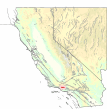
was less than 5,000 years ago. Recent research indicates that the San
Cayetano fault may have been the source of the
573:
206:
198:
36:
672:
480:
475:
687:
558:
588:
553:
470:
435:
397:
382:
80:
60:
377:
578:
563:
367:
490:
500:
277:
111:
56:
593:
427:
317:
312:
287:
269:
44:
40:
525:
505:
455:
337:
292:
48:
568:
485:
417:
372:
347:
332:
254:
171:
603:
495:
460:
407:
387:
161:
151:
119:
64:
52:
19:
535:
515:
510:
440:
392:
302:
232:
76:
115:
99:
412:
259:
651:
545:
465:
450:
402:
352:
342:
297:
307:
32:
608:
530:
520:
282:
156:
139:
240:
229:
175:
236:
166:
123:
43:. It stretches for 45 kilometers (28 mi), north of the city of
18:
202:
23:
The San
Cayetano Fault in Southern California, United States
544:
426:
268:
247:
104:Bulletin of the Seismological Society of America
214:
8:
584:Rescue Lineament-Bear Mountains fault zone
221:
207:
199:
165:
155:
98:Dolan, J. F.; Rockwell, T. K. (2001),
663:Geology of Ventura County, California
194:Southern California Earthquake Center
7:
446:Clayton-Marsh Creek-Greenville Fault
144:Earth and Planetary Science Letters
14:
599:Sierra Nevada-Great Valley Block
1:
328:Northridge Blind Thrust Fault
658:Seismic faults of California
627:California Geological Survey
81:December 21, 1812 earthquake
632:Seismic Hazards Mapping Act
363:San Diego Trough Fault Zone
16:Seismic fault in California
704:
574:Maria fold and thrust belt
157:10.1016/j.epsl.2018.10.003
617:
481:Mount Diablo Thrust Fault
476:Mendocino Triple Junction
31:is an east-west trending
559:Furnace Creek Fault Zone
678:Santa Paula, California
589:Sierra Nevada Batholith
554:Death Valley Fault Zone
471:Mendocino Fracture Zone
398:Sierra Madre Fault Zone
383:Santa Maria River Fault
323:Newport–Inglewood Fault
63:, Sulphur Springs, and
436:Bartlett Springs Fault
378:San Jacinto Fault Zone
24:
564:Honey Lake Fault Zone
368:San Felipe Fault Zone
22:
668:Fillmore, California
278:Brawley Seismic Zone
594:Sierra Nevada Fault
428:Northern California
318:Laguna Salada Fault
313:Imperial Fault Zone
288:Elsinore Fault Zone
270:Southern California
116:2001BuSSA..91.1417D
41:Southern California
683:Topatopa Mountains
579:Owens Valley Fault
526:Silver Creek Fault
506:San Gregorio Fault
456:Hayward Fault Zone
358:San Cayetano Fault
338:Puente Hills Fault
293:Elysian Park Fault
230:Seismically active
190:San Cayetano Fault
124:10.1785/0120000602
49:Topatopa Mountains
29:San Cayetano Fault
25:
645:
644:
569:Kern Canyon Fault
486:Monta Vista Fault
418:Yorba Linda Fault
373:San Gabriel Fault
348:Rose Canyon Fault
333:Peninsular Ranges
255:San Andreas Fault
695:
673:Ojai, California
604:Smartville Block
496:Pleasanton Fault
491:Nacimiento Fault
461:Healdsburg Fault
408:White Wolf Fault
388:Santa Ynez Fault
248:Statewide Faults
223:
216:
209:
200:
179:
169:
159:
126:
110:(6): 1417–1432,
703:
702:
698:
697:
696:
694:
693:
692:
688:Plate tectonics
648:
647:
646:
641:
613:
540:
536:West Napa Fault
516:Seal Cove Fault
511:San Pablo Fault
501:Rinconada Fault
441:Calaveras Fault
422:
393:Shoreline Fault
303:Hollywood fault
264:
243:
237:tectonic blocks
227:
186:
137:
134:
132:Further reading
129:
97:
93:
77:surface rupture
75:The last known
73:
17:
12:
11:
5:
701:
699:
691:
690:
685:
680:
675:
670:
665:
660:
650:
649:
643:
642:
640:
639:
634:
629:
624:
618:
615:
614:
612:
611:
606:
601:
596:
591:
586:
581:
576:
571:
566:
561:
556:
550:
548:
542:
541:
539:
538:
533:
528:
523:
518:
513:
508:
503:
498:
493:
488:
483:
478:
473:
468:
463:
458:
453:
448:
443:
438:
432:
430:
424:
423:
421:
420:
415:
413:Whittier Fault
410:
405:
400:
395:
390:
385:
380:
375:
370:
365:
360:
355:
350:
345:
340:
335:
330:
325:
320:
315:
310:
305:
300:
295:
290:
285:
280:
274:
272:
266:
265:
263:
262:
260:Salinian Block
257:
251:
249:
245:
244:
228:
226:
225:
218:
211:
203:
197:
196:
185:
184:External links
182:
181:
180:
133:
130:
128:
127:
94:
92:
89:
72:
69:
37:Ventura County
15:
13:
10:
9:
6:
4:
3:
2:
700:
689:
686:
684:
681:
679:
676:
674:
671:
669:
666:
664:
661:
659:
656:
655:
653:
638:
637:Mexico (list)
635:
633:
630:
628:
625:
623:
620:
619:
616:
610:
607:
605:
602:
600:
597:
595:
592:
590:
587:
585:
582:
580:
577:
575:
572:
570:
567:
565:
562:
560:
557:
555:
552:
551:
549:
547:
546:Sierra Nevada
543:
537:
534:
532:
529:
527:
524:
522:
519:
517:
514:
512:
509:
507:
504:
502:
499:
497:
494:
492:
489:
487:
484:
482:
479:
477:
474:
472:
469:
467:
466:Maacama Fault
464:
462:
459:
457:
454:
452:
451:Concord Fault
449:
447:
444:
442:
439:
437:
434:
433:
431:
429:
425:
419:
416:
414:
411:
409:
406:
404:
403:Ventura Fault
401:
399:
396:
394:
391:
389:
386:
384:
381:
379:
376:
374:
371:
369:
366:
364:
361:
359:
356:
354:
353:Salton Trough
351:
349:
346:
344:
343:Raymond Fault
341:
339:
336:
334:
331:
329:
326:
324:
321:
319:
316:
314:
311:
309:
306:
304:
301:
299:
298:Garlock Fault
296:
294:
291:
289:
286:
284:
281:
279:
276:
275:
273:
271:
267:
261:
258:
256:
253:
252:
250:
246:
242:
238:
234:
231:
224:
219:
217:
212:
210:
205:
204:
201:
195:
191:
188:
187:
183:
177:
173:
168:
167:10044/1/64539
163:
158:
153:
149:
145:
141:
136:
135:
131:
125:
121:
117:
113:
109:
105:
101:
96:
95:
90:
88:
84:
82:
78:
70:
68:
66:
62:
58:
54:
50:
46:
42:
38:
34:
30:
21:
357:
308:Hosgri Fault
147:
143:
107:
103:
85:
74:
33:thrust fault
28:
26:
609:Walker Lane
531:Tesla Fault
521:Serra Fault
283:Chino Fault
233:fault zones
150:: 198–210.
61:Santa Paula
47:, near the
652:Categories
241:California
91:References
176:0012-821X
622:Category
57:Fillmore
112:Bibcode
71:Geology
45:Ventura
174:
235:and
172:ISSN
65:Ojai
53:Piru
27:The
239:of
162:hdl
152:doi
148:504
120:doi
83:.
35:in
654::
192:–
170:.
160:.
146:.
142:.
118:,
108:91
106:,
102:,
67:.
59:,
55:,
51:,
39:,
222:e
215:t
208:v
178:.
164::
154::
122::
114::
Text is available under the Creative Commons Attribution-ShareAlike License. Additional terms may apply.