Portal maintenance status: (March 2022)
|
ကြိုဆိုပါတယ်။ / Welcome to the Myanmar Portal 

Myanmar, officially the Republic of the Union of Myanmar and also known as Burma (the official name until 1989), is a country in Southeast Asia. It is the largest country by area in Mainland Southeast Asia and has a population of about 55 million. It is bordered by India to its west, Bangladesh to its southwest, China to its northeast, Laos and Thailand to its east and southeast, and the Andaman Sea and the Bay of Bengal to its south and southwest. The country's capital city is Naypyidaw, and its largest city is Yangon (formerly Rangoon).
Myanmar is a member of the East Asia Summit, Non-Aligned Movement, ASEAN, and BIMSTEC, but it is not a member of the Commonwealth of Nations despite once being part of the British Empire. Myanmar is a Dialogue Partner of the Shanghai Cooperation Organization. The country is very rich in natural resources, such as jade, gems, oil, natural gas, teak and other minerals, as well as also endowed with renewable energy, having the highest solar power potential compared to other countries of the Great Mekong Subregion. However, Myanmar has long suffered from instability, factional violence, corruption, poor infrastructure, as well as a long history of colonial exploitation with little regard to human development. In 2013, its GDP (nominal) stood at US$56.7 billion and its GDP (PPP) at US$221.5 billion. The income gap in Myanmar is among the widest in the world, as a large proportion of the economy is controlled by cronies of the military junta. Myanmar is one of the least developed countries; as of 2020, according to the Human Development Index, it ranks 147 out of 189 countries in terms of human development, the lowest in Southeast Asia. Since 2021, more than 600,000 people were displaced across Myanmar due to the surge in violence post-coup, with more than 3 million people in dire need of humanitarian assistance. (Full article...)
Selected articles - load new batch
-
 Image 1
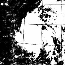 Satellite image of the cyclone on May 9
The 1968 Burma cyclone was regarded as the worst to strike the country during the 20th century before it was surpassed by another unnamed cyclone in 2004 and further, Cyclone Nargis in 2008, respectively. The first tropical cyclone of the 1968 North Indian Ocean cyclone season, it started as a depression on May 7 on the northern Andaman Sea. With low wind shear and warm sea surface temperatures, the storm intensified in the waters near Burma before heading northwestwards. It then started to rapidly intensify, with an eye becoming apparent on satellite imagery on May 9. Also that day, it reached its peak intensity, with 3-minute maximum sustained winds of 220 km/h (140 mph) by the Indian Meteorological Department, which is equivalent to a super cyclonic storm; however, the agency treated the system as a severe cyclonic storm. Little to no changes happened on the cyclone as it turned northeastwards, making landfall near Akyab (now Sittwe) between 18:00 and 21:00 UTC on that day. Land interaction rapidly weakened the storm, dissipating on May 10 as an area of low-pressure in south Chin State.
The predecessor to the cyclone caused light to moderate downpour to the Andaman Islands; however, no deaths were reported. Winds reported from the cyclone inland Burma reached an estimate of 60–100 mph, altogether with heavy rainfall and large storm surges. The former flooded the crops, submerging them in floodwaters in the process while the latter washed out villages near the path of the storm. Schools and hospitals throughout Akyab were destroyed by high winds and large waves, while the port suffered major damages. The town was almost destroyed due to the storm. In addition, some ships in the said harbor, including the Greek freighter Geros Michalos were reportedly sunk in the Bay of Bengal. Houses were destroyed during the storm and many livestock died, mainly due to drowning. The death toll from the cyclone was finalized in May 1968 at 1,037 individuals, while 2,000 more were reportedly missing. The property damages were estimated at Ks.15 million ($3.248 million USD). (Full article...) -
Image 2
 Map of Bay of Bengal
The Bay of Bengal is the northeastern part of the Indian Ocean. The world's largest bay, geographically it is positioned between the Indian subcontinent and the Indochinese peninsula, located below the Bengal region.
Many South Asian and Southeast Asian countries are dependent on the Bay of Bengal. Geopolitically, the bay is bounded on the west and northwest by India, on the north by Bangladesh, and on the east by Myanmar and the Andaman and Nicobar Islands of India. Its southern limit is a line between Sangaman Kanda, Sri Lanka, and the northwesternmost point of Sumatra, Indonesia. Cox's Bazar, the longest sea beach in the world and Sundarbans, the largest mangrove forest and the natural habitat of the Bengal tiger, are located along the bay. (Full article...) -
Image 3
 A KNLA medic treats IDPs in Hpapun District, Kayin State.
The Karen conflict is an armed conflict in Kayin State, Myanmar (formerly known as Karen State, Burma). It is part of the wider internal conflict in Myanmar between the military government and various minority groups. Karen nationalists have been fighting for an independent state, known as Kawthoolei, since 1949. The Karen National Union (KNU) and its Karen National Liberation Army (KNLA) are the most prominent Karen rebel groups. Hundreds of thousands of civilians have been displaced by the conflict, many of whom fled to neighbouring Thailand and survive in refugee camps.
Tensions between the Karen people and the Bamar ethnic majority in Myanmar have existed since colonial-era based on the British 'direct and indirect rule' policy and Karen soldiers' roles in putting down Burmese rebellions in the late 19th century. Around the time of Burmese independence, the Karen National Defence Organisation (KNDO) was formed as an armed wing of the Karen National Union (KNU) to put down a communist rebellion. After the Burmese government settled for peace and allowed communist back into national politics, a series of tensions, escalations and battles led to the KNU declaring formally war on the Burmese government on 31 January 1949. (Full article...) -
Image 4
 Confluence of Ruak River and Mekong Rivers, view from Wat Phra That Doi Pu Khao [th] in Ban Sop Ruak
The Golden Triangle is a large, mountainous region of approximately 200,000 km (77,000 sq mi) in northeastern Myanmar, northwestern Thailand and northern Laos, centered on the confluence of the Ruak and Mekong rivers. The name "Golden Triangle" was coined by Marshall Green, a U.S. State Department official, in 1971 in a press conference on the opium trade. Today, the Thai side of the river confluence, Sop Ruak, has become a tourist attraction, with the House of Opium Museum, a Hall of Opium, and a Golden Triangle Park, and no opium cultivation.
The Golden Triangle has been one of the largest opium-producing areas of the world since the 1950s. Most of the world's heroin came from the Golden Triangle until the early 21st century when opium production in Afghanistan increased. Myanmar was the world's second-largest source of opium after Afghanistan up to 2022, producing some 25% of the world's opium, forming part of the Golden Triangle. While opium poppy cultivation in Myanmar had declined year-on-year since 2015, cultivation area increased by 33% totalling 40,100 ha (99,000 acres) alongside an 88% increase in yield potential to 790 t (780 long tons; 870 short tons) in 2022 according to latest data from the United Nations Office on Drugs and Crime (UNODC) Myanmar Opium Survey 2022. The United Nations Office on Drugs and Crime has also warned that opium production in Myanmar may rise again if the economic crunch brought on by COVID-19 and the country's 2021 Myanmar coup d'état persists, with significant public health and security consequences for much of Asia. (Full article...) -
Image 5Nga Tet Pya (Burmese: ငတက်ပြား, [ŋətɛʔpjá], also [ŋədɛʔbjá]; also spelled Ngatetpya or Nga Tat Pya) was a 14th-century Burmese outlaw who later became a commander in the royal army during the reign of King Thado Minbya of Ava. A well-known folkloric figure in Burmese culture, he is remembered as a Robin Hood-like character, who robbed the rich, and shared his loot with the poor. He is also known as the husband of Chantha, who is venerated by believers as the Amay Gyan nat spirit. (Full article...)
-
Image 6On 2 July 2020, a major landslide at the Wai Khar jade mining site in the Hpakant area of Kachin State, Myanmar, killed between 175 and 200 miners in the country's deadliest-ever mining accident. At 06:30 local time (MMT) heavy rains triggered the collapse of a heap of mining waste, which came tumbling down into a lake. This generated a 6.1-meter (20 ft) wave of mud and water that buried those working at the Wai Khar mine. The miners killed or injured by the landslide were independent "jade pickers", who scavenge tailings from larger operators and who live in ramshackle quarters at the base of large mounds of rubble.
Myanmar's jade industry supplies 70% to 90% of the world jade supply. The industry had become known for its fatal accidents in the preceding years, with the previous deadliest accident in 2015 killing 116 people. While the government responded with promises of reforms in the jade mining industry, activists claim that little has been done in practice since then. (Full article...) -
Image 7

The 1912 Maymyo earthquake or Burma earthquake struck Burma on the morning of May 23, with an epicentre near Taunggyi and Pyin Oo Lwin in Shan State. The earthquake was initially calculated at 8.0 on the surface wave magnitude scale (Ms ) by Beno Gutenberg and Charles Francis Richter, and described by them as being one of the most remarkable seismic events in the early 1900s. Recent re-evaluation of the earthquake, however, have revised the magnitude to 7.6–7.9. It was preceded by two foreshocks on May 18 and 21 with respective intensities V and VII on the Rossi–Forel scale, while the mainshock was assigned IX. Shaking was felt throughout most of Burma, parts of Siam and Yunnan; an area covering approximately 375,000 square miles. It was one of the largest earthquakes in the country. (Full article...) -
Image 8

The Burma Railway, also known as the Siam–Burma Railway, Thai–Burma Railway and similar names, or as the Death Railway, is a 415 km (258 mi) railway between Ban Pong, Thailand, and Thanbyuzayat, Burma (now called Myanmar). It was built from 1940 to 1943 by South East Asian civilians abducted and forced to work by the Japanese and a smaller group of captured Allied soldiers, to supply troops and weapons in the Burma campaign of World War II. It completed the rail link between Bangkok, Thailand, and Rangoon, Burma. The name used by the Japanese Government was Tai–Men Rensetsu Tetsudō (泰緬連接鉄道), which means Thailand-Burma-Link-Railway.
At least 250,000 Southeast Asian civilians were subjected to forced labour to ensure the construction of the Death Railway and more than 90,000 civilians died building it, as did around 12,000 Allied soldiers. The workers on the Thai side of the railway were Tamils, Malays, and fewer Chinese civilians from Malaya. (Full article...) -
Image 9
 The Buddha giving a discourse on Māgha Pūjā
Myanmar (also written as Makha Bucha Day) is a Buddhist festival celebrated on the full moon day of the third lunar month in Cambodia, Laos, Thailand, Sri Lanka and on the full moon day of Tabaung in Myanmar. It is the second most important Buddhist festival after Vesak; it celebrates a gathering that was held between the Buddha and 1,250 of his first disciples, which, according to tradition, preceded the custom of periodic recitation of discipline by monks. On the day, Buddhists celebrate the creation of an ideal and exemplary community, which is why it is sometimes called Saṅgha Day, the Saṅgha referring to the Buddhist community, and for some Buddhist schools this is specifically the monastic community. In Thailand, the Pāli term Māgha-pūraṇamī is also used for the celebration, meaning 'to honor on the full moon of the third lunar month'. Finally, some authors referred to the day as the Buddhist All Saints Day.
In pre-modern times, Māgha Pūjā has been celebrated by some Southeast Asian communities. But it became widely popular in the modern period, when it was instituted in Thailand by King Rama IV in the mid-19th century. From Thailand, it spread to other South and Southeast Asian countries. Presently, it is a public holiday in some of these countries. It is an occasion when Buddhists go to the temple to perform merit-making activities, such as alms giving, meditation and listening to teachings. It has been proposed in Thailand as a more spiritual alternative to the celebration of Valentine's Day. (Full article...) -
Image 10
 Location in Myanmar
Indawgyi Lake Wildlife Sanctuary is a biosphere reserve in Myanmar, covering 814.99 km (314.67 sq mi). It ranges in elevation from 105–1,400 m (344–4,593 ft) encompassing the surroundings of Indawgyi Lake in Mohnyin Township, Kachin State. It was gazetted in 2004, is recognized as an Important Bird Area and as one of the ASEAN Heritage Parks.
An area of 478.84 km (184.88 sq mi) comprising the lake and the surrounding lowland is a Ramsar site since February 2016.
During a survey in the winter of 2004, both resident and migratory birds were sighted on the lake and along Indawgyi River, including white-rumped vulture (Gyps bengalensis), slender-billed vulture (G. tenuirostris), Himalayan vulture (G. himalayensis), lesser whistling duck (Dendrocygna javanica), tufted duck (Aythya fuligula), ferruginous pochard (A. nyroca), gadwall (Mareca strepera), ruddy shelduck (Tadorna ferruginea), Eurasian teal (Anas crecca), northern pintail (A. acuta), greylag goose (Anser anser), Eurasian coot (Fulica atra), little grebe (Tachybaptus ruficollis), great crested grebe (Podiceps cristatus), little cormorant (Microcarbo niger), purple heron (Ardea purpurea), brown-headed gull (Chroicocephalus brunnicephalus), black-headed gull (C. ridibundus), wood sandpiper (Tringa glareola), Temminck's stint (Calidris temminckii), black-winged stilt (Himantopus himantopus), grey-headed lapwing (Vanellus cinereus) and glossy ibis (Plegadis falcinellus). (Full article...)
Did you know (auto-generated) - load new batch

- ... that Rangoon kept its own time for more than two decades after Burma Standard Time first came into effect?
- ... that while defending Zaw Myint Maung following his arrest by the Myanmar junta, lawyer Ywet Nu Aung was herself arrested and charged?
- ... that former Burmese actress Honey Nway Oo turned rebel and took up arms against the military junta following the 2021 Myanmar coup d'état?
- ... that the Myanmar Photo Archive (example photograph shown) revealed "a side of modern Myanmar that, until very recently, remained hidden in dusty attics"?
- ... that clashes between the Myanmar military and local armed groups broke out in Lay Kay Kaw six years after it was established as a "town of peace" between the parties?
- ... that the talabaw soup, which consists primarily of bamboo shoots, is the essential dish of Myanmar's Karen people, who use it to supplement rice?
- ... that the Burmese and South Korean first ladies held their first informal conversation 44 years after the establishment of bilateral relations between the two countries?
- ... that the mission of the United Nations special envoy on Myanmar has been called a "diplomatic graveyard"?
Related portals and projects
Southeast Asia
Other Countries
General images - load new batch
-
 Image 1Recorder's Court on Sule Pagoda Road, with the Sule Pagoda at the far end, Rangoon, 1868. Photographer: J. Jackson. (from History of Myanmar)
 -
 Image 2Protesters in Yangon carrying signs reading "Free Daw Aung San Suu Kyi" on 8 February 2021. (from History of Myanmar)
 -

-
 Image 4Portuguese ruler and soldiers mounting an Elephant. Philips, Jan Caspar (draughtsman and engraver) (from History of Myanmar)
 -
 Image 5Political Map of Burma (Myanmar) c. 1450 CE. (from History of Myanmar)
 -
 Image 6British soldiers remove their shoes at the entrance of Shwedagon Pagoda. To the left, a sign reads "Foot wearing is strictly prohibited" in Burmese, English, Tamil, and Urdu. (from Culture of Myanmar)
 -
 Image 7Aerial view of a burned Rohingya village in Rakhine state, September 2017 (from History of Myanmar)
 -

-
 Image 9British soldiers dismantling cannons belonging to King Thibaw's forces, Third Anglo-Burmese War, Ava, 27 November 1885. Photographer: Hooper, Willoughby Wallace (1837–1912). (from History of Myanmar)
 -
 Image 10Pagan Kingdom during Narapatisithu's reign. Burmese chronicles also claim Kengtung and Chiang Mai. Core areas shown in darker yellow. Peripheral areas in light yellow. Pagan incorporated key ports of Lower Burma into its core administration by the 13th century. (from History of Myanmar)
 -
 Image 11Former US President Barack Obama poses barefoot on the grounds of Shwedagon Pagoda, one of Myanmar's major Buddhist pilgrimage sites. (from Culture of Myanmar)
 -
 Image 12Boxing match, 19th-century watercolour (from Culture of Myanmar)
 -
 Image 13British soldiers on patrol in the ruins of the Burmese town of Bahe during the advance on Mandalay, January 1945. (from History of Myanmar)
 -
 Image 14A group of Buddhist worshipers at Shwedagon Pagoda, an important religious site for Burmese Buddhists (from Culture of Myanmar)
 -
 Image 15Grandfather Island, Dawei (from Geography of Myanmar)
 -

-
 Image 17Temples at Mrauk U, was the capital of the Mrauk U Kingdom, which ruled over what is now Rakhine State. (from History of Myanmar)
 -
 Image 18The shores of Irrawaddy River at Nyaung-U, Bagan (from Geography of Myanmar)
 -
 Image 19Myinhkin thabin - equestrian sport (from Culture of Myanmar)
 -
 Image 20Two female musicians play the saung at a performance in Mandalay. (from Culture of Myanmar)
 -
 Image 21A large fracture on the Mingun Pahtodawgyi caused by the 1839 Ava earthquake. (from Geography of Myanmar)
 -
 Image 22A bull fight, 19th-century watercolour (from Culture of Myanmar)
 -
 Image 23Vegetable stall on the roadside at the Madras Lancer Lines, Mandalay, January 1886. Photographer: Hooper, Willoughby Wallace (1837–1912). (from History of Myanmar)
 -

-
 Image 25Salween river at Mae Sam Laep on the Thai-Myanmar border (from Geography of Myanmar)
 -

-
 Image 27Protesters in Yangon with a banner that reads non-violence: national movement in Burmese, in the background is Shwedagon Pagoda. (from History of Myanmar)
 -

-
 Image 29The restored Taungoo or Nyaungyan dynasty c. 1650 CE. (from History of Myanmar)
 -
 Image 3019th-century funeral cart and spire, which would form part of the procession from the home to the place of cremation (from Culture of Myanmar)
 -
 Image 31The paddle steamer Ramapoora (right) of the British India Steam Navigation Company on the Rangoon river having just arrived from Moulmein. 1895. Photographers: Watts and Skeen (from History of Myanmar)
 -
 Image 32A theatrical performance of the Mon dance (from Culture of Myanmar)
 -
 Image 33Myanmar (Burma) map of Köppen climate classification (from Geography of Myanmar)
 -

-
 Image 35Hlei pyaingbwè - a Burmese regatta (from Culture of Myanmar)
 -
 Image 36Saint Mary's Cathedral in Downtown Yangon is the largest Roman Catholic cathedral in Burma. (from Culture of Myanmar)
 -
 Image 37Aung San Suu Kyi addresses crowds at the NLD headquarters shortly after her release. (from History of Myanmar)
 -
 Image 38A wedding procession, with the groom and bride dressed in traditional Burmese wedding clothes, reminiscent of royal attire (from Culture of Myanmar)
 -

-
 Image 40Sculpture of Myanmar mythical lion (from Culture of Myanmar)
Major topics
Categories

More topics

Associated Wikimedia
The following Wikimedia Foundation sister projects provide more on this subject:
-
 Commons
Free media repository -
 Wikibooks
Free textbooks and manuals -
 Wikidata
Free knowledge base -
 Wikinews
Free-content news -
 Wikiquote
Collection of quotations -
 Wikisource
Free-content library -
 Wikiversity
Free learning tools -
 Wikivoyage
Free travel guide -
 Wiktionary
Dictionary and thesaurus


