Portal maintenance status: (June 2018)
|
The Earth Sciences Portal

Earth science or geoscience includes all fields of natural science related to the planet Earth. This is a branch of science dealing with the physical, chemical, and biological complex constitutions and synergistic linkages of Earth's four spheres: the biosphere, hydrosphere/cryosphere, atmosphere, and geosphere (or lithosphere). Earth science can be considered to be a branch of planetary science but with a much older history. (Full article...)
Selected articles
-
 Image 1
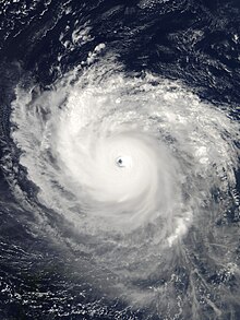 Isabel at peak intensity, northeast of the Leeward Islands, on September 11
Hurricane Isabel was the strongest Atlantic hurricane since Mitch, and the deadliest, costliest, and most intense hurricane in the 2003 Atlantic hurricane season. Hurricane Isabel was also the strongest hurricane in the open waters of the Atlantic, both by wind speed and central pressure, before being surpassed by hurricanes Irma and Dorian in 2017 and 2019, respectively. The ninth named storm, fifth hurricane, and second major hurricane of the season, Isabel formed near the Cape Verde Islands from a tropical wave on September 6, in the tropical Atlantic Ocean. It moved northwestward, and within an environment of light wind shear and warm waters, it steadily strengthened to reach peak winds of 165 mph (266 km/h) on September 11. After fluctuating in intensity for four days, during which it displayed annular characteristics, Isabel gradually weakened and made landfall on the Outer Banks of North Carolina, with winds of 105 mph (169 km/h) on September 18. Isabel quickly weakened over land and became extratropical over western Pennsylvania on the next day. On September 20, the extratropical remnants of Isabel were absorbed into another system over Eastern Canada.
In North Carolina, the storm surge from Isabel washed out a portion of Hatteras Island to form what was unofficially known as Isabel Inlet. Damage was greatest along the Outer Banks, where thousands of homes were damaged or even destroyed. The worst of the effects of Isabel occurred in Virginia, especially in the Hampton Roads area and along the shores of rivers as far west and north as Richmond and Baltimore. Virginia reported the most deaths and damage from the hurricane. About 64% of the damage and 69% of the deaths occurred in North Carolina and Virginia. Electric service was disrupted in areas of Virginia for several days, some more rural areas were without electricity for weeks, and local flooding caused thousands of dollars in damage. (Full article...) -
Image 2
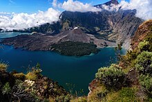 View of Mount Samalas along with Mount Rinjani
In 1257, a catastrophic eruption occurred at Samalas, a volcano on the Indonesian island of Lombok. The event had a probable Volcanic Explosivity Index of 7, making it one of the largest volcanic eruptions during the Holocene epoch. It left behind a large caldera that contains Lake Segara Anak. Later volcanic activity created more volcanic centres in the caldera, including the Barujari cone, which remains active.
The event created eruption columns reaching tens of kilometres into the atmosphere and pyroclastic flows that buried much of Lombok and crossed the sea to reach the neighbouring island of Sumbawa. The flows destroyed human habitations, including the city of Pamatan, which was the capital of a kingdom on Lombok. Ash from the eruption fell as far as 340 kilometres (210 mi) away in Java; the volcano deposited more than 10 cubic kilometres (2.4 cu mi) of rocks and ash. (Full article...) -
Image 3
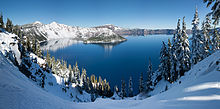 Panoramic winter view of Crater Lake from Rim Village
Crater Lake (Klamath: Giiwas) is a volcanic crater lake in south-central Oregon in the Western United States. It is the main feature of Crater Lake National Park and is famous for its deep blue color and water clarity. The lake partly fills a 2,148-foot-deep (655 m) caldera that was formed around 7,700 (± 150) years ago
by the collapse of the volcano Mount Mazama. No rivers flow into or out of the lake; the evaporation is compensated for by rain and snowfall at a rate such that the total amount of water is replaced every 150 years. With a depth of 1,949 feet (594 m), the lake is the deepest in the United States. In the world, it ranks tenth for maximum depth, as well as third for mean (average) depth.
Crater Lake features two small islands. Wizard Island, located near the western shore of the lake, is a cinder cone about 316 acres (128 hectares) in size. Phantom Ship, a natural rock pillar, is located near the southern shore. (Full article...) -
Image 4
 Rain-obscured shot of the F3 tornado in Gallatin, Tennessee that killed seven people.
The tornado outbreak of April 6–8, 2006, was a major tornado outbreak in the central and parts of the southern United States that began on April 6, 2006, in the Great Plains and continued until April 8 in South Carolina, with most of the activity on April 7. The hardest-hit region was Middle Tennessee, where several strong tornadoes devastated entire neighborhoods and left ten people dead. Some of the worst damage took place in Gallatin, Tennessee, and other communities north of Nashville also sustained significant damage.
There were 73 tornadoes confirmed across 13 states, with the bulk of them coming on the afternoon and evening of April 7 across the South, particularly in Tennessee. In total, 10 deaths were reported as a result of the tornadoes, and over $650 million in damage was reported, of which over $630 million was in Middle Tennessee. It was the third major outbreak of 2006, occurring just days after another major outbreak on April 2. It was also considered by some to be the worst disaster event in Middle Tennessee since the 1998 tornado outbreak. (Full article...) -
Image 5
 The Berlin Archaeopteryx specimen (A. siemensii)
Archaeopteryx (/ˌɑːrkiːˈɒptərɪks/; lit. 'old-wing'), sometimes referred to by its German name, "Urvogel" (lit. Primeval Bird) is a genus of bird-like dinosaurs. The name derives from the ancient Greek ἀρχαῖος (archaīos), meaning "ancient", and πτέρυξ (ptéryx), meaning "feather" or "wing". Between the late 19th century and the early 21st century, Archaeopteryx was generally accepted by palaeontologists and popular reference books as the oldest known bird (member of the group Avialae). Older potential avialans have since been identified, including Anchiornis, Xiaotingia, and Aurornis.
Archaeopteryx lived in the Late Jurassic around 150 million years ago, in what is now southern Germany, during a time when Europe was an archipelago of islands in a shallow warm tropical sea, much closer to the equator than it is now. Similar in size to a Eurasian magpie, with the largest individuals possibly attaining the size of a raven, the largest species of Archaeopteryx could grow to about 0.5 m (1 ft 8 in) in length. Despite their small size, broad wings, and inferred ability to fly or glide, Archaeopteryx had more in common with other small Mesozoic dinosaurs than with modern birds. In particular, they shared the following features with the dromaeosaurids and troodontids: jaws with sharp teeth, three fingers with claws, a long bony tail, hyperextensible second toes ("killing claw"), feathers (which also suggest warm-bloodedness), and various features of the skeleton. (Full article...) -
Image 6

The inner planets. From left to right: Mercury, Venus, Earth, Mars and terrestrial dwarf planet, Ceres (sizes to scale)
The geology of solar terrestrial planets mainly deals with the geological aspects of the four terrestrial planets of the Solar System – Mercury, Venus, Earth, and Mars – and one terrestrial dwarf planet: Ceres. Earth is the only terrestrial planet known to have an active hydrosphere.
Terrestrial planets are substantially different from the giant planets, which might not have solid surfaces and are composed mostly of some combination of hydrogen, helium, and water existing in various physical states. Terrestrial planets have a compact, rocky surfaces, and Venus, Earth, and Mars each also has an atmosphere. Their size, radius, and density are all similar. (Full article...) -
Image 7
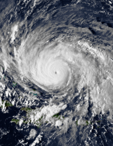 Gloria near peak intensity north of Hispaniola on September 24
Hurricane Gloria was a powerful hurricane that caused significant damage along the east coast of the United States and in Atlantic Canada during the 1985 Atlantic hurricane season. It was the first significant tropical cyclone to strike the northeastern United States since Hurricane Agnes in 1972 and the first major storm to affect New York City and Long Island directly since Hurricane Donna in 1960. Gloria was a Cape Verde hurricane originating from a tropical wave on September 16 in the eastern Atlantic Ocean. After remaining a weak tropical cyclone for several days, Gloria intensified into a hurricane on September 22 north of the Lesser Antilles. During that time, the storm had moved generally westward, although it turned to the northwest due to a weakening of the ridge. Gloria quickly intensified on September 24, and the next day reached peak winds of 145 mph (233 km/h). The hurricane weakened before striking the Outer Banks of North Carolina on September 27. Later that day, Gloria made two subsequent landfalls on Long Island and across the coastline of western Connecticut, before becoming extratropical on September 28 over New England. The remnants moved through Atlantic Canada and went on to impact Western Europe, eventually dissipating on October 4.
Before Gloria made landfall, the National Hurricane Center issued hurricane warnings at some point for the East Coast of the United States from South Carolina to Maine. Hundreds of thousands of people evacuated, and the hurricane was described as the "storm of the century." In general, Gloria's strongest winds remained east of the center, which largely spared locations from North Carolina to New Jersey, and the passage at low tide reduced storm surge. Hurricane-force winds and gusts affected much of the path, which knocked down trees and power lines. This left over 4 million people without power, causing the worst power outage in Connecticut history related to a natural disaster. Fallen trees caused six of the storm's fourteen deaths. (Full article...) -
Image 8
 Cannikin warhead being lowered into test shaft
Amchitka (/æmˈtʃɪtkə/; Aleut: Amchixtax̂;) is a volcanic, tectonically unstable and uninhabited
island in the Rat Islands group of the Aleutian Islands in southwest Alaska. It is part of the Alaska Maritime National Wildlife Refuge. The island, with a land area of roughly 116 square miles (300 km), is about 42 miles (68 km) long and 1 to 4 miles (1.6 to 6.4 km) wide. The area has a maritime climate, with many storms, and mostly overcast skies.
Amchitka was populated for more than 2,500 years by the Aleut people, but has had no permanent population since 1832. The island has been part of the United States since the Alaska Purchase of 1867. During World War II, it was used as an airfield by US forces in the Aleutian Islands Campaign. (Full article...) -
Image 9
 The Blue Marble, Apollo 17, December 1972
Earth is the third planet from the Sun and the only astronomical object known to harbor life. This is enabled by Earth being an ocean world, the only one in the Solar System sustaining liquid surface water. Almost all of Earth's water is contained in its global ocean, covering 70.8% of Earth's crust. The remaining 29.2% of Earth's crust is land, most of which is located in the form of continental landmasses within Earth's land hemisphere. Most of Earth's land is somewhat humid and covered by vegetation, while large sheets of ice at Earth's polar deserts retain more water than Earth's groundwater, lakes, rivers and atmospheric water combined. Earth's crust consists of slowly moving tectonic plates, which interact to produce mountain ranges, volcanoes, and earthquakes. Earth has a liquid outer core that generates a magnetosphere capable of deflecting most of the destructive solar winds and cosmic radiation.
Earth has a dynamic atmosphere, which sustains Earth's surface conditions and protects it from most meteoroids and UV-light at entry. It has a composition of primarily nitrogen and oxygen. Water vapor is widely present in the atmosphere, forming clouds that cover most of the planet. The water vapor acts as a greenhouse gas and, together with other greenhouse gases in the atmosphere, particularly carbon dioxide (CO2), creates the conditions for both liquid surface water and water vapor to persist via the capturing of energy from the Sun's light. This process maintains the current average surface temperature of 14.76 °C (58.57 °F), at which water is liquid under normal atmospheric pressure. Differences in the amount of captured energy between geographic regions (as with the equatorial region receiving more sunlight than the polar regions) drive atmospheric and ocean currents, producing a global climate system with different climate regions, and a range of weather phenomena such as precipitation, allowing components such as nitrogen to cycle. (Full article...) -
Image 10

Mahameru (Semeru) above Mount Bromo, East Java.
The geography of Indonesia is dominated by volcanoes that are formed due to subduction zones between the Eurasian Plate and the Indo-Australian Plate. Some of the volcanoes are notable for their eruptions, for instance, Krakatoa for its global effects in 1883, the Lake Toba Caldera for its supervolcanic eruption estimated to have occurred 74,000 years before present which was responsible for six years of volcanic winter, and Mount Tambora for the most violent eruption in recorded history in 1815. (Full article...) -
Image 11

Map of Earth's 16 principal tectonic plates
Divergent:Extension zoneConvergent:Collision zoneTransform:Sinistral transform
Plate tectonics (from Latin tectonicus, from Ancient Greek τεκτονικός (tektonikós) 'pertaining to building') is the scientific theory that Earth's lithosphere comprises a number of large tectonic plates, which have been slowly moving since 3–4 billion years ago. The model builds on the concept of continental drift, an idea developed during the first decades of the 20th century. Plate tectonics came to be accepted by geoscientists after seafloor spreading was validated in the mid-to-late 1960s.
Earth's lithosphere, the rigid outer shell of the planet including the crust and upper mantle, is fractured into seven or eight major plates (depending on how they are defined) and many minor plates or "platelets". Where the plates meet, their relative motion determines the type of plate boundary (or fault): convergent, divergent, or transform. The relative movement of the plates typically ranges from zero to 10 cm annually. Faults tend to be geologically active, experiencing earthquakes, volcanic activity, mountain-building, and oceanic trench formation. (Full article...) -
Image 12
A geyser (/ˈɡaɪzər/, UK: /ˈɡiːzər/) is a spring with an intermittent discharge of water ejected turbulently and accompanied by steam. The formation of geysers is fairly rare, and is caused by particular hydrogeological conditions that exist only in a few places on Earth.
Generally, geyser field sites are located near active volcanic areas, and the geyser effect is due to the proximity of magma. Surface water works its way down to an average depth of around 2,000 metres (6,600 ft) where it contacts hot rocks. The pressurized water boils, and this causes the geyser effect of hot water and steam spraying out of the geyser's surface vent. (Full article...) -
Image 13

Geologic time shown in a diagram called a geological clock, showing the relative lengths of the eons of Earth's history and noting major events
The geological history of the Earth follows the major geological events in Earth's past based on the geological time scale, a system of chronological measurement based on the study of the planet's rock layers (stratigraphy). Earth formed about 4.54 billion years ago by accretion from the solar nebula, a disk-shaped mass of dust and gas left over from the formation of the Sun, which also created the rest of the Solar System.
Initially, Earth was molten due to extreme volcanism and frequent collisions with other bodies. Eventually, the outer layer of the planet cooled to form a solid crust when water began accumulating in the atmosphere. The Moon formed soon afterwards, possibly as a result of the impact of a planetoid with the Earth. Outgassing and volcanic activity produced the primordial atmosphere. Condensing water vapor, augmented by ice delivered from comets, produced the oceans. However, in 2020, researchers reported that sufficient water to fill the oceans may have always been on the Earth since the beginning of the planet's formation. (Full article...) -
Image 14
The Chicxulub crater (IPA: [t͡ʃikʃuˈluɓ] cheek-shoo-LOOB) is an impact crater buried underneath the Yucatán Peninsula in Mexico. Its center is offshore, but the crater is named after the onshore community of Chicxulub Pueblo (not the larger coastal town of Chicxulub Puerto). It was formed slightly over 66 million years ago when an asteroid, about ten kilometers (six miles) in diameter, struck Earth. The crater is estimated to be 200 kilometers (120 miles) in diameter and 1 kilometer (0.62 miles) in depth. It is believed to be the second largest impact structure on Earth, and the only one whose peak ring is intact and directly accessible for scientific research.
The crater was discovered by Antonio Camargo and Glen Penfield, geophysicists who had been looking for petroleum in the Yucatán Peninsula during the late 1970s. Penfield was initially unable to obtain evidence that the geological feature was a crater and gave up his search. Later, through contact with Alan R. Hildebrand in 1990, Penfield obtained samples that suggested it was an impact feature. Evidence for the crater's impact origin includes shocked quartz, a gravity anomaly, and tektites in surrounding areas. (Full article...) -
Image 15

The ACFEL ice auger showing an ice core pushed up into the core remover barrel.
Ice drilling allows scientists studying glaciers and ice sheets to gain access to what is beneath the ice, to take measurements along the interior of the ice, and to retrieve samples. Instruments can be placed in the drilled holes to record temperature, pressure, speed, direction of movement, and for other scientific research, such as neutrino detection.
Many different methods have been used since 1840, when the first scientific ice drilling expedition attempted to drill through the Unteraargletscher in the Alps. Two early methods were percussion, in which the ice is fractured and pulverized, and rotary drilling, a method often used in mineral exploration for rock drilling. In the 1940s, thermal drills began to be used; these drills melt the ice by heating the drill. Drills that use jets of hot water or steam to bore through ice soon followed. A growing interest in ice cores, used for palaeoclimatological research, led to ice coring drills being developed in the 1950s and 1960s, and there are now many different coring drills in use. For obtaining ice cores from deep holes, most investigators use cable-suspended electromechanical drills, which use an armoured cable to carry electrical power to a mechanical drill at the bottom of the borehole. (Full article...) -
Image 16

A scene in Uttarakhand's Valley of Flowers National Park. In contrast to the rain shadow region of Tirunelveli, the park receives ample orographic precipitation due to its location in a mountainous windward-facing region wedged between the Zanskars and the Greater Himalayas.
The climate of India consists of a wide range of weather conditions across a vast geographic scale and varied topography. Based on the Köppen system, India encompasses a diverse array of climatic subtypes. These range from arid and semi-arid regions in the west to highland, sub-arctic, tundra, and ice cap climates in the northern Himalayan regions, varying with elevation. The northern lowlands experience subtropical conditions, with some areas at higher altitudes, like Srinagar, touching continental climates. In contrast, much of the south and the east exhibit tropical climate conditions, which support lush rainforests in these territories. Many regions have starkly different microclimates, making it one of the most climatically diverse countries in the world. The country's meteorological department follows the international standard of four seasons with some local adjustments: winter (December to February), summer (March to May), monsoon or rainy season (June to September), and a post-monsoon period (October and November).
India's geography and geology are climatically pivotal: the Thar Desert in the northwest and the Himalayas in the north work in tandem to create a culturally and economically important monsoonal regime. As Earth's highest and most massive mountain range, the Himalayas bar the influx of frigid katabatic winds from the icy Tibetan Plateau and northerly Central Asia. Most of North India is thus kept warm or is only mildly chilly or cold during winter; the same thermal dam keeps most regions in India hot in summer. The climate in South India is generally warmer, and more humid due to its coastlines. However some hill stations in South India such as Ooty are well known for their cold climate. (Full article...) -
Image 17

The 1867 Manhattan earthquake struck Riley County, Kansas, in the United States on April 24, 1867, at 20:22 UTC, or about 14:30 local time. The strongest earthquake to originate in the state, it measured 5.1 on a seismic scale that is based on an isoseismal map or the event's felt area. The earthquake's epicenter was near the town of Manhattan.
The earthquake had a maximum perceived intensity of VII (Very strong) on the Mercalli intensity scale. It caused minor damage, reports of which were confined to Kansas, Iowa, and Missouri, according to the United States Geological Survey. Felt over an area of 200,000 square miles (520,000 km), the earthquake reached the states of Indiana, Illinois, and possibly Ohio, though the latter reports have been questioned. (Full article...) -
Image 18
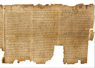
Radiocarbon dating helped verify the authenticity of the Dead Sea scrolls.
Radiocarbon dating (also referred to as carbon dating or carbon-14 dating) is a method for determining the age of an object containing organic material by using the properties of radiocarbon, a radioactive isotope of carbon.
The method was developed in the late 1940s at the University of Chicago by Willard Libby, based on the constant creation of radiocarbon (
C) in the Earth's atmosphere by the interaction of cosmic rays with atmospheric nitrogen. The resulting
C combines with atmospheric oxygen to form radioactive carbon dioxide, which is incorporated into plants by photosynthesis; animals then acquire
C by eating the plants. When the animal or plant dies, it stops exchanging carbon with its environment, and thereafter the amount of
C it contains begins to decrease as the
C undergoes radioactive decay. Measuring the proportion of
C in a sample from a dead plant or animal, such as a piece of wood or a fragment of bone, provides information that can be used to calculate when the animal or plant died. The older a sample is, the less
C there is to be detected, and because the half-life of
C (the period of time after which half of a given sample will have decayed) is about 5,730 years, the oldest dates that can be reliably measured by this process date to approximately 50,000 years ago (in this interval about 99.8% of the
C will have decayed), although special preparation methods occasionally make an accurate analysis of older samples possible. In 1960, Libby received the Nobel Prize in Chemistry for his work. (Full article...) -
Image 19

Life in the Ediacaran Period as imagined by researchers in 1980.
The Ediacaran (/ˌiːdiˈækərən/; formerly Vendian) biota is a taxonomic period classification that consists of all life forms that were present on Earth during the Ediacaran Period (c. 635–538.8 Mya). These were enigmatic tubular and frond-shaped, mostly sessile, organisms. Trace fossils of these organisms have been found worldwide, and represent the earliest known complex multicellular organisms. The term "Ediacara biota" has received criticism from some scientists due to its alleged inconsistency, arbitrary exclusion of certain fossils, and inability to be precisely defined.
The Ediacaran biota may have undergone evolutionary radiation in a proposed event called the Avalon explosion, 575 million years ago. This was after the Earth had thawed from the Cryogenian period's extensive glaciation. This biota largely disappeared with the rapid increase in biodiversity known as the Cambrian explosion. Most of the currently existing body plans of animals first appeared in the fossil record of the Cambrian rather than the Ediacaran. For macroorganisms, the Cambrian biota appears to have almost completely replaced the organisms that dominated the Ediacaran fossil record, although relationships are still a matter of debate. (Full article...) -
Image 20Calabozos is a Holocene caldera in central Chile's Maule Region (7th Region). Part of the Chilean Andes' volcanic segment, it is considered a member of the Southern Volcanic Zone (SVZ), one of the three distinct volcanic belts of South America. This most active section of the Andes runs along central Chile's western edge, and includes more than 70 of Chile's stratovolcanoes and volcanic fields. Calabozos lies in an extremely remote area of poorly glaciated mountains.
Calabozos and the majority of the Andean volcanoes formed from the subduction of the oceanic Nazca Plate under the continental South American continental lithosphere. The caldera is in a transitional region between thick and thin lithosphere, and is probably supplied by a pool of andesitic and rhyolitic magma. It sits on a historic bed of volcanic and plutonic sedimentary rock (rock formed within the Earth) that in turn sits on top of a layer of merged sedimentary and metamorphic rock. (Full article...) -
Image 21
 White Chuck Glacier in the United States in 1973
The retreat of glaciers since 1850 is well documented and is one of the effects of climate change. The retreat of mountain glaciers provide evidence for the rise in global temperatures since the late 19th century. Examples include mountain glaciers in western North America, Asia, the Alps in central Europe and tropical and subtropical regions of South America and Africa. Since glacial mass is affected by long-term climatic changes, e.g., precipitation, mean temperature, and cloud cover, glacial mass changes are one of the most sensitive indicators of climate change. Retreat of glaciers is also a major reason for sea level rise. Excluding peripheral glaciers of ice sheets, the total cumulated global glacial losses over the 26-year period from 1993 to 2018 were likely 5500 gigatons, or 210 gigatons per yr.
On Earth, 99% of glacial ice is contained within vast ice sheets (also known as "continental glaciers") in the polar regions. Glaciers also exist in mountain ranges on every continent other than the Australian mainland, including Oceania's high-latitude oceanic island countries such as New Zealand. Glacial bodies larger than 50,000 km (19,000 sq mi) are called ice sheets. They are several kilometers deep and obscure the underlying topography. (Full article...) -
Image 22
The 2002 Bou'in-Zahra earthquake (also known as the 2002 Avaj earthquake or the 2002 Changureh earthquake) occurred on 22 June 2002. The epicenter was near the city of Bou'in-Zahra in Qazvin Province, a region of northwestern Iran which is crossed by several major faults that is known for destructive earthquakes. The shock measured 6.5 on the Mwc scale, had a maximum Mercalli intensity of VIII (Severe), and was followed by more than 20 aftershocks. At least 230 people were killed and 1,500 more were injured.
According to the International Institute of Earthquake Engineering and Seismology (IIEES), the earthquake was felt as far away as the capital city of Tehran, approximately 290 kilometres (180 mi) east of the epicenter, although no damage was reported there. Most houses in the region were single-story masonry buildings, and virtually all of these collapsed. The public became angry due to the slow official response to victims who needed supplies. Residents of the town of Avaj resorted to throwing stones at the car of a government minister. (Full article...) -
Image 23
The 1949 Ambato earthquake was the deadliest earthquake in the Western Hemisphere in five years. On August 5, 1949, it struck Ecuador's Tungurahua Province southeast of its capital Ambato and killed 5,050 people. Measuring 6.4 on the Ms scale, it originated from a hypocenter 15 km beneath the surface. The nearby villages of Guano, Patate, Pelileo, and Pillaro were destroyed, and the city of Ambato suffered heavy damage. The earthquake flattened buildings and subsequent landslides caused damage throughout the Tungurahua, Chimborazo, and Cotopaxi Provinces. It disrupted water mains and communication lines and opened a fissure into which the small town of Libertad sank. Moderate shaking from the event extended as far away as Quito and Guayaquil.
Earthquakes in Ecuador stem from two major interrelated tectonic areas: the subduction of the Nazca Plate under the South American Plate and the Andean Volcanic Belt. The 1949 Ambato earthquake initially followed an intersection of several northwest-southeast-trending faults in the Inter-Andean Valley which were created by the subduction of the Carnegie Ridge. Strata of rock cracked as the earthquake ruptured the faults, sending out powerful shock waves. Today threats exist throughout the country from both interplate and intraplate seismicity. (Full article...) -
Image 24
 A map of the world as it appeared during the mid-Ediacaran, c. 600 Ma
The Ediacaran (/ˌiːdiˈækərən,ˌɛdi-/ EE-dee-AK-ər-ən, ED-ee-) is a geological period of the Neoproterozoic Era that spans 96 million years from the end of the Cryogenian Period at 635 Mya to the beginning of the Cambrian Period at 538.8 Mya. It is the last period of the Proterozoic Eon as well as the last of the so-called "Precambrian supereon", before the beginning of the subsequent Cambrian Period marks the start of the Phanerozoic Eon, where recognizable fossil evidence of life becomes common.
The Ediacaran Period is named after the Ediacara Hills of South Australia, where trace fossils of a diverse community of previously unrecognized lifeforms (later named the Ediacaran biota) were first discovered by geologist Reg Sprigg in 1946. Its status as an official geological period was ratified in 2004 by the International Union of Geological Sciences (IUGS), making it the first new geological period declared in 120 years. Although the period took namesake from the Ediacara Hills in the Nilpena Ediacara National Park, the type section is actually located in the bed of the Enorama Creek within the Brachina Gorge in the Ikara-Flinders Ranges National Park, at , approximately 55 km (34 mi) southeast of the Ediacara Hills fossil site. (Full article...) -
Image 25
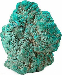
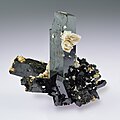
Turquoise is an opaque, blue-to-green mineral that is a hydrous phosphate of copper and aluminium, with the chemical formula CuAl6(PO4)4(OH)8·4H2O. It is rare and valuable in finer grades and has been prized as a gemstone for millennia due to its hue.
Like most other opaque gems, turquoise has been devalued by the introduction of treatments, imitations, and synthetics into the market. The robin egg blue or sky blue color of the Persian turquoise mined near the modern city of Nishapur, Iran, has been used as a guiding reference for evaluating turquoise quality. (Full article...)


Did you know (auto-generated)

- ... that the most significant rock from New Caledonia is peridotite, which comes from the Earth's mantle?
- ... that Frederick Murray Trotter had a distinguished career as a field geologist despite losing a part of his skull and an eye to shrapnel during World War I?
- ... that the Apollo 12 Solar Wind Spectrometer detected a gas-ion shockwave produced by the impact of the Apollo 13 S-IVB stage on the lunar surface?
- ... that life exists in every part of the biosphere, from the deepest parts of the ocean to altitudes of up to 64 km (40 miles) in the atmosphere?
- ... that the Danish geologist Tove Birkelund received a gold medal for her early work on fossils of Scaphites in Greenland?
- ... that the geology of the Ellsworth Mountains was explored by geologists using motor toboggans in 1961?
- ... that the Iowa Colored Cowboys played softball for audiences of over a thousand people, in an atmosphere similar to a Harlem Globetrotters show?
More did you know? - show different entries

- ...that nearly 10 years before the 2008 Atlanta Tornado, the Dunwoody Tornado (pictured) caused significant damage just outside the city limits?
- ...that the Lorain-Sandusky tornado was both the deadliest tornado and part of the deadliest tornado outbreak in Ohio history?
- ...that Cyclone Gamede in February 2007 was among the wettest tropical cyclones on record, dropping more than 5.5 m (18 ft) in a nine day period on Réunion island?
- ...that in Madagascar and Mozambique, Cyclone Jokwe killed 16 people, left at least 55400 homeless, and destroyed nearly 10000 houses?
- ...that following the Cambrian explosion, about 535 mya, there have been five mass extinctions?
- ... that geophysical methods have been used to look for the palace of Cleopatra?
Related portals
Selected images
-
 Image 1Tsunami in Thailand at 2004 Indian Ocean earthquake and tsunami, by David Rydevik (from Knowledge (XXG):Featured pictures/Sciences/Geology)
 -

-
-
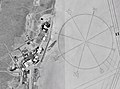 Image 4The world's largest compass rose, drawn on the desert floor at Edwards Air Force Base in California, United States. Painted on the playa near Dryden Flight Research Center, it is inclined to magnetic north and is used by pilots for calibrating heading indicators. (Credit: NASA.) (from Portal:Earth sciences/Selected pictures)
 -

-

-

-
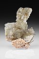
 Image 8Specimen from a palaeontological site of Lebanon at Paleontology in Lebanon, by Mila Zinkova (from Knowledge (XXG):Featured pictures/Sciences/Geology)
 -
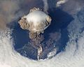 Image 9Sarychev Peak at Explosive eruption, by NASA (from Knowledge (XXG):Featured pictures/Sciences/Geology)
 -
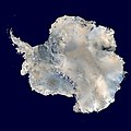 Image 10Antarctica, the continent surrounding the Earth's South Pole, is the coldest place on earth and is almost entirely covered by ice. Antarctica was discovered in late January 1820. Too cold and dry to support virtually any vascular plants, Antarctica's flora presently consists of around 250 lichens, 100 mosses, 25-30 liverworts, and around 700 terrestrial and aquatic algal species. (Credit: NASA.) (from Portal:Earth sciences/Selected pictures)
 -

-
 Image 12A 2002 eruption of Mount Etna, a volcano on the Italian island of Sicily, viewed from the International Space Station. (Credit: NASA, with image edits by User:Darkone.) (from Portal:Earth sciences/Selected pictures)
 -
-

-
 Image 15Diatomaceous earth, by Richard Wheeler (from Knowledge (XXG):Featured pictures/Sciences/Geology)
 -
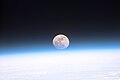 Image 16Astronauts aboard the Space Shuttle Discovery recorded this rarely seen phenomenon of the full Moon partially obscured by the atmosphere of Earth. The image was recorded with an electronic still camera at 15:15:15 GMT, Dec. 21, 1999. (Credit: NASA.) (from Portal:Earth sciences/Selected pictures)
 -
 Image 17Blairmorite, by Paul Glombick (edited by Bammesk) (from Knowledge (XXG):Featured pictures/Sciences/Geology)
 -
 Image 18A true-color picture of Ireland, as seen from space, with the Atlantic Ocean to the west and the Irish Sea to the east. (from Portal:Earth sciences/Selected pictures)
 -

-
 Image 20Oceans cover almost three quarters (71%) of the surface of the Earth, and nearly half of the world's marine waters are over 3000 m deep. This global, interconnected body of salt water, called the World Ocean, is divided by the continents and archipelagos into the following five bodies, from the largest to the smallest: the Pacific Ocean, the Atlantic Ocean, the Indian Ocean, the Southern Ocean, and the Arctic Ocean. Official boundaries are defined by the International Hydrographic Organization. (Credit: Alexandre Van de Sande.) (from Portal:Earth sciences/Selected pictures)
 -
-

-

-
 Image 24Winter is one of the four seasons of temperate zones. Meteorological winter is the season having the shortest days (which vary greatly according to latitude) and the lowest temperatures. (Credit: Richard Fabi.) (from Portal:Earth sciences/Selected pictures)
 -
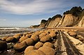
 Image 25Erosion of the bluff in Pacifica, by mbz1 (from Knowledge (XXG):Featured pictures/Sciences/Geology)
 -
-

-
 Image 28An October 2002 eruption of Mount Etna, a volcano on the Italian island of Sicily, as seen from the International Space Station. Etna is the largest of Italy's three active volcanoes and one of the most active in the whole entire world. This eruption, one of Etna's most vigorous in years, was triggered by a series of earthquakes. Ashfall was reported as far away as Libya, 600 km (373 mi) to the south. (Credit: Expedition 5 crew.) (from Portal:Earth sciences/Selected pictures)
 -
 Image 29Satellite image of Cyclone Gafilo, a powerful Category 5 tropical cyclone which struck Madagascar in March 2004, causing devastating damage. This was taken just before landfall, when the system was at its peak intensity about 333 km (207 mi) east of Madagascar, with sustained windspeed of 260 km/h (160 mph). At least 250 people were listed dead, with more missing, and 300,000 people were left homeless due to Gafilo. (Credit: Terra satellite, NASA.) (from Portal:Earth sciences/Selected pictures)
 -
 Image 30Hurricane Katrina was the third most powerful storm of the 2005 Atlantic hurricane season. It first made landfall as a Category 1 hurricane just north of Miami, Florida on August 25, 2005, then again on August 29 along the Central Gulf Coast near Buras-Triumph, Louisiana as a Category 4 storm. This photograph of the eye of the hurricane was taken from a NOAA Hurricane Hunter aircraft on August 28, 2005. (Credit: NOAA.) (from Portal:Earth sciences/Selected pictures)
 -
 Image 31A thunderstorm is a form of severe weather involving lightning and thunder. Thunderstorms have had a lasting and powerful influence on mankind. Romans thought them to be battles waged by Jupiter. Thunderstorms were associated with the Thunderbird, held by Native Americans to be a servant of the Great Spirit. (Credit: John Kerstholt.) (from Portal:Earth sciences/Selected pictures)
 -

-
 Image 33Glacier retreat is a type of glacial motion in which more material ablates from its terminus of the glacier than is replenished by flow into that region. In this region of the Bhutan-Himalaya, glacial lakes have been rapidly forming on the surface of the debris-covered glaciers and researchers have found a strong correlation between increasing temperatures and glacial retreat. (Credit: NASA & USGS.) (from Portal:Earth sciences/Selected pictures)
 -
 Image 34The Richat Structure is a depression in the country of Mauritania, almost 50 km (30 mi) across. It was originally thought to be the impact of a meteorite. Now it is thought to be a symmetrical uplift (circular anticline or dome) that has been exposed to erosion. In this false-color photo, bedrock is brown, sand is yellow and white, vegetation is green, and salty sediments are blue. (Credit: Landsat 7.) (from Portal:Earth sciences/Selected pictures)
 -

-

-
-

-
-

-
-

-

-
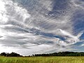 Image 44Cirrus clouds are composed of ice crystals and shaped like hairlike filaments. They are formed at an altitudes above 5000 metres (16,500 feet). The streaks are made of snowflakes that are falling from the cloud and being caught by the high level winds. The streaks point in the direction of the wind and may appear straight giving the clouds the appearance of a comma (cirrus uncinus), or may by seem tangled, an indication of high level turbulence. (Credit: Piccolo Namek.) (from Portal:Earth sciences/Selected pictures)
 -
-
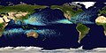 Image 46This map shows the tracks of all tropical cyclones that formed worldwide from 1985 to 2005. The points show the locations of the storms at six-hourly intervals and use the color scheme shown on the right from the Saffir-Simpson Hurricane Scale. (Credit: Nilfanion.) (from Portal:Earth sciences/Selected pictures)
 -

-
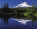 Image 48Mount Hood reflected in Mirror Lake, Oregon. (Credit: Oregon's Mt. Hood Territory.) (from Portal:Earth sciences/Selected pictures)
 -

-
 Image 50Ant trapped in Baltic amber, by Baltic-amber-beetle (edited by AmericanXplorer13) (from Knowledge (XXG):Featured pictures/Sciences/Geology)
 -

-

-

-
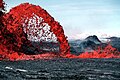 Image 54Incandescent Pahoeoe Fountain at Shield volcano, by J.D. Griggs, USGS (from Knowledge (XXG):Featured pictures/Sciences/Geology)
 -

-
-

-
 Image 58Erg Chebbi (Arabic: عرج شبّي) is the sole Saharan erg in Morocco. It is 22 km long (North-South) and 5 km wide. Its dunes reach a maximum height of 150 meters. It is located roughly 40 kilometers south-east of Erfoud. The local center for tourists is the village of Merzouga. (Credit: Rosa Cabecinhas and Alcino Cunha.) (from Portal:Earth sciences/Selected pictures)
 -

-

-
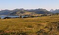 Image 61Northern shore meadows of Sihlsee, an artificial lake near Einsiedeln in the Canton of Schwyz, Switzerland. (Credit: Markus Bernet.) (from Portal:Earth sciences/Selected pictures)
 -
 Image 62Weathered rocks at Joshua Tree National Park, by Mila Zinkova (from Knowledge (XXG):Featured pictures/Sciences/Geology)
 -
 Image 63Pressure release of granite in the Enchanted Rock State Natural Area of Texas, United States. The photo shows the geological exfoliation of granite dome rock. (Taken by Wing-Chi Poon on 2nd April 2005.) (from Portal:Earth sciences/Selected pictures)
 -
 Image 64Petrified log at Petrified Forest National Park, by Moondigger (from Knowledge (XXG):Featured pictures/Sciences/Geology)
 -
 Image 652004 Indian Ocean Earthquake tsunami at 2004 Indian Ocean earthquake and tsunami, by Vasily V. Titov, NOAA (edited by Veledan) (from Knowledge (XXG):Featured pictures/Sciences/Geology)
 -

-

-
-
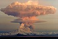 Image 69Mount Redoubt eruption, by R. Clucas (USGS) (edited by Janke) (from Knowledge (XXG):Featured pictures/Sciences/Geology)
 -

-
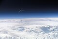 Image 71Atmospheric gases scatter blue wavelengths of visible light more than other wavelengths, giving the Earth’s visible edge a blue halo. At higher and higher altitudes, the atmosphere becomes so thin that it essentially ceases to exist. Gradually, the atmospheric halo fades into the blackness of space. (Credit: NASA's Earth Observatory.) (from Portal:Earth sciences/Selected pictures)
 -

-
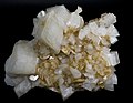 Image 73Crystalline dolomite and magnesite, by Didier Descouens (from Knowledge (XXG):Featured pictures/Sciences/Geology)
 -

-

In the news
- 24 September 2024 –
- A Monash University-led study on the Ordovician meteor event provides evidence that rings may have existed around Earth approximately 446 million years ago. (Forbes)
- 18 September 2024 – Russian invasion of Ukraine
- A Ukrainian drone attack on a Russian weapons depot in Toropets, Tver Oblast, causes an explosion large enough to be detected as an earthquake by monitoring stations. Local residents are told to evacuate and schools in the region are closed. (The Guardian)
- 15 September 2024 – Polaris program
- The spacecraft of the Polaris Dawn private spaceflight mission operated by SpaceX returns to Earth after five days in orbit. (BBC News)
- 7 September 2024 –
- The Boeing Crew Flight Test capsule returns to Earth uncrewed, landing at the White Sands Space Harbor in New Mexico, United States, after being docked for three months at the International Space Station. (CNN)
- 5 September 2024 –
- American rock band Linkin Park emerges from a seven-year hiatus with the announcement of an upcoming studio album, a worldwide concert tour, and introduces Emily Armstrong as the band's new co-vocalist. The band went on hiatus in 2017 following the death of then-lead vocalist Chester Bennington. (Rolling Stone)
- 4 September 2024 –
- A small 1.5-metre (4.9 ft) asteroid, 2024 RW1, is predicted to fall harmlessly as a fireball over the island of Luzon in the Philippines at approximately 16:40 UTC (00:40 local time), the ninth asteroid to be successfully discovered before impacting Earth. (New Scientist)
Subcategories

- Select to view subcategories
Related topics
| Atmosphere | Hydrosphere | Lithosphere |
|---|---|---|
| Biosphere | Systems | Others |
| Categories |
|---|
Quality content

- Climate change (More...)
Global warming · Rachel Carson · Retreat of glaciers since 1850
- Earthquakes (More...)
1949 Ambato earthquake · 1968 Illinois earthquake · 1980 eruption of Mount St. Helens · 1997 Qayen earthquake · 2002 Bou'in-Zahra earthquake · 2005 Qeshm earthquake · 2007–2008 Nazko earthquakes
- Volcanoes (More...)
1980 eruption of Mount St. Helens · 2007–2008 Nazko earthquakes · Amchitka · Armero tragedy · Calabozos · Cerro Azul (Chile volcano) · Craters of the Moon National Monument and Preserve · David A. Johnston · Geology of the Lassen volcanic area · Loihi Seamount · Mauna Kea · Mauna Loa · Metacomet Ridge · Mono–Inyo Craters · Mount Cayley volcanic field · Mount St. Helens · Mount Tambora · Nevado del Ruiz · Surtsey · The Volcano (British Columbia) · Upper and Lower Table Rock · Volcano (South Park) · Yellowstone National Park
- Other geology (More...)
Mary Anning · Archaea · Archaeopteryx · Cerro Azul (Chile volcano) · Bryce Canyon National Park · Calabozos · Chicxulub crater · Cretaceous–Paleogene extinction event · Charles Darwin · Earth · Ediacara biota · Geology of the Bryce Canyon area · Geology of the Capitol Reef area · Geology of the Death Valley area · Geology of the Grand Canyon area · Geology of the Lassen volcanic area · Geology of the Zion and Kolob canyons area · Global warming · Iridium · Oil shale · The Volcano (British Columbia) · Toronto Magnetic and Meteorological Observatory · Volcanology of Io · Yellowstone National Park
- Geography (More...)
Antarctica · Australia · Bryce Canyon National Park · Carlsbad Caverns National Park · Craters of the Moon National Monument and Preserve · Death Valley National Park · Geography of India · Geography of Ireland · National parks of England and Wales · Niagara Falls · Rondane National Park · Shoshone National Forest · Yellowstone National Park · Yosemite National Park · Zion National Park
1941 Atlantic hurricane season · 1991 Atlantic hurricane season · 1995 Pacific hurricane season · 1998 Pacific hurricane season · 2002 Atlantic hurricane season · 2003 Atlantic hurricane season · Category 5 Pacific hurricanes · Hurricane Isabel · Lists of Florida hurricanes · Lists of North Carolina hurricanes
· Retired Pacific hurricanes- Baja California Peninsula hurricanes
- California hurricanes
- Category 5 Atlantic hurricanes
- Category 5 Pacific hurricanes
- Delaware hurricanes
- Florida hurricanes
- Florida hurricanes (pre-1900)
- Florida hurricanes (1900–1949)
- Florida hurricanes (1950–1974)
- Florida hurricanes (1975–1999)
- Florida hurricanes (2000–present)
- Largest volcanic eruptions
- New Jersey hurricanes
- New York hurricanes
- North Carolina hurricanes
- North Carolina hurricanes (pre-1900)
- North Carolina hurricanes (1900–1949)
- North Carolina hurricanes (1950–1979)
- North Carolina hurricanes (1980–present)
- Retired Pacific hurricane names
- Retired Pacific typhoon names (JMA)
- Sites of special scientific interest in Cornwall
- Snow events in Florida
- South America tropical cyclones
- Storms in the 2003 Atlantic hurricane season
- Storms in the 2005 Atlantic hurricane season
- Timeline of the far future
- United States hurricanes
- volcanoes in the Hawaiian – Emperor seamount chain
- Volcanoes in Indonesia
- Wettest tropical cyclones in the United States
WikiProjects


Things you can do

- Edit an Earth sciences article
- Whether you are an expert or a novice, be bold, improve an article by editing it. If you're not sure how to do it, practice in the sandbox.
- Add new articles:
- John H. Roscoe
- G.D. Blodgett
- Cross section (geology)
- Strunzite
- Koscierzyna borehole
- Versoyen unit
- Magnetic chronozone
- Fleischerite
- Mineralogical Association of Canada
- Phosphosiderite
- Menezesite
- Yuanshan Formation
- Berzeliite
- Sartorite
- Sorosite
- Colusite
- Internal Valais
- Cernyite
- David J. Siveter
- Johnbaumite
- Moûtiers unit
- Join one of the WikiProjects listed below.
- Watch its talk page for earth science-related issues on Knowledge (XXG).
- Improve this portal
- Add to the Did you know list.
- Add new Selected articles and Selected pictures to the queues.
- See Contributing to Knowledge (XXG) for more ideas.
Associated Wikimedia
The following Wikimedia Foundation sister projects provide more on this subject:
-
 Commons
Free media repository -
 Wikibooks
Free textbooks and manuals -
 Wikidata
Free knowledge base -
 Wikinews
Free-content news -
 Wikiquote
Collection of quotations -
 Wikisource
Free-content library -
 Wikiversity
Free learning tools -
 Wiktionary
Dictionary and thesaurus


